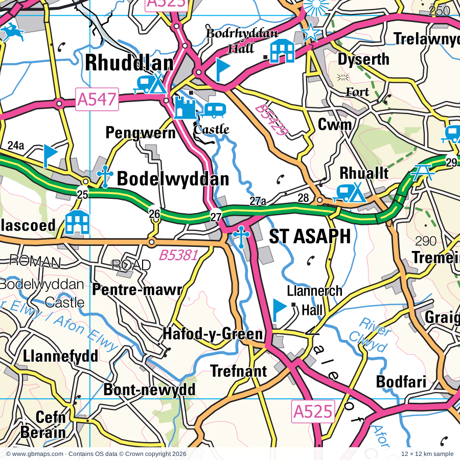
St Asaph regional road map. Full 60 × 60 km PDF, SVG and Illustrator files, with a free PDF sample.

GBMAPS.COM

St Asaph Regional Road Map

Call Us Now for Help01751 473136

GREAT BRITAIN ROAD ATLAS · 1:250,000 GB-300-0360

St Asaph & surrounding area

Explore the full 60 × 60 km St Asaph regional road map at 1:250,000, covering St Asaph, Denbigh, Rhuddlan, Abergele, Llanrwst. Compare the complete coverage below; a detailed PDF sample is available free.

ST ASAPH & SURROUNDING AREAREGIONAL ROAD MAP
60 × 60 km · Full map previewDownload the free SVG ↓

INSIDE THE FULL 60 × 60 KM MAP

Explore the St Asaph map area

1:250,000 cartography

Towns, villages & places

More mapped places (194)
  • Heswall
  • Chirk
  • Hoylake
  • Nantglyn
  • Saron
  • Bylchau
  • Peniel
  • Groes
  • Tan-y-fron
  • Prion
  • Cyffylliog
  • Henllan
  • Bryn Rhyd-yr-Arian
  • Bontuchel
  • Llanrhaeadr
  • Clocaenog
  • Llanynys
  • Llannefydd
  • Bont-newydd
  • Rhewl
  • Llanfwrog
  • Cefn-brith
  • Derwen
  • Efenechtyd
  • Melin-y-Wig
  • Cerrigydrudion
  • Trefnant
  • Waen
  • Gwytherin
  • Bryn Saith Marchog
  • Glasfryn
  • Gellifor
  • Ffordd-las
  • Pennant
  • Llangynhafal
  • Glascoed
  • Llangwyfan
  • Bodfari
  • Hirwaen
  • Rhydlydan
  • Llanelidan
  • Llangernyw
  • Graig
  • Ty-nant
  • Gwyddelwern
  • Pentrefoelas
  • Pentre Isaf
  • Tremeirchion
  • Maerdy
  • Rhyd-y-meudwy
  • Bodelwyddan
  • Llangwm
  • St George
  • Pentre-celyn
  • Gellioedd
  • Betws-yn-Rhos
  • Rhuallt
  • Nebo
  • Druid
  • Glan-yr-afon
  • Gell
  • Wenallt
  • Corwen
  • Cilcain
  • Cwm
  • Melin-y-coed
  • Dolwen
  • Dawn
  • Trofarth
  • Pen-y-cefn
  • Llanferres
  • Nannerch
  • Ysceifiog
  • Ysbyty Ifan
  • Pensarn
  • Bryneglwys
  • Towyn
  • Cynwyd
  • Carrog
  • Llanddoged
  • Dyserth
  • Llysfaen
  • Maeshafn
  • Kinmel Bay
  • Eryrys
  • Llanddulas
  • Lixwm
  • Hendre
  • Cadole
  • Sarnau
  • Babell
  • Glan-yr-afon
  • Llandegla
  • Rhydymwyn
  • Gwernymynydd
  • Cefn-ddwysarn
  • Trelawnyd
  • Meliden
  • Graianrhyd
  • Eglwysbach
  • Trefriw
  • Frongoch
  • Gorsedd
  • Gwaenysgor
  • Graig
  • Brynford
  • Glyndyfrdwy
  • Penmachno
  • Llandderfel
  • Rhosesmor
  • Llandrillo
  • Nercwys
  • Halkyn
  • Rhewl
  • Trelogan
  • Dolgarrog
  • Llanasa
  • Rhiwlas
  • Rhydtalog
  • Llanfor
  • Rhyd-uchaf
  • Pentrefelin
  • Tal-y-bont
  • Gronant
  • Caerhun
  • Sychdyn
  • Treuddyn
  • Pont-y-pant
  • Ty'n-y-groes
  • Gwespyr
  • Northop
  • Mostyn
  • Rhos-y-gwaliau
  • Ffynnongroyw
  • Berwyn
  • Mynydd Isa
  • Llong
  • Whelston
  • Walwen
  • Llanycil
  • Pont-Cyfyng
  • Bagillt
  • Pontybodkin
  • Rowen
  • Bwlchgwyn
  • Leeswood
  • Talacre
  • Henryd
  • Dolwyddelan
  • Padeswood
  • Capel Curig
  • Llanfynydd
  • Penrhyn Bay
  • Minera
  • Pentre
  • Parc
  • Ffrith
  • Llangower
  • Drury
  • Coedpoeth
  • Glyn Ceiriog
  • Brymbo
  • Capelulo
  • Garth
  • Ewloe
  • Pandy
  • Dwygyfylchi
  • Tregeiriog
  • Pen-y-cae
  • Llwynmawr
  • Pontfadog
  • Llanuwchllyn
  • Acrefair
  • Froncysyllte
  • Gogarth
  • Cefn-mawr
  • Caldy
  • Newbridge
  • Rhiwlas
  • Thurstaston
  • Pentre
  • Llangadwaladr
  • Llan Ffestiniog
  • Bronygarth
  • Craignant
  • Frankby
  • Selattyn
  • Greasby
  • Barnston
  • Rhydycroesau
  • Trawsfynydd
  • Llawnt
  • Hengoed
  • Bronaber

Roads across this sheet

M53, A470, A525, A539, A540, A541, A542, A543, A544, A546, A547, A548, A549, A550, A551, A552, A553, A4086, A4212, A5026, A5027, A5104, A5118, A5119

More road numbers

A5137, A5151, B4391, B4401, B4402, B4403, B4406, B4407, B4500, B4501, B4579, B4580, B5009, B5069, B5070, B5096, B5097, B5101, B5102, B5103, B5105, B5106, B5113, B5115, B5116, B5118, B5119, B5120, B5121, B5122, B5123, B5125, B5126, B5128, B5129, B5134, B5135, B5136, B5138, B5139, B5140, B5141, B5151, B5192, B5279, B5328, B5329, B5381, B5382, B5383, B5384, B5426, B5427, B5428, B5429, B5430, B5431, B5432, B5433, B5434, B5435, B5436, B5437, B5444, B5605

Rivers & waterways

Afon Aled, Afon Alwen, Afon Ceirw, Afon Cledwen, Afon Conwy, Afon Ddu, Afon Dulyn, Afon Eden, Afon Llafar, Afon Llugwy, Afon Machno, Afon Mawddach

More waterways

Afon Porth-llwyd, Afon Tryweryn, Afon Ystrad, Llangollen Canal, River Alyn / Afon Alun, River Ceiriog, River Clwyd / Afon Clwyd, River Dee / Afon Dyfrdwy, River Elwy / Afon Elwy, River Gele / Afon Gele

Landmarks & landscape

Aberconwy House, Afon Wen Craft and Antique Centre, Anvil Pottery, Arrowe Country Park, Basingwerk Abbey, Bodelwyddan Castle, National Portrait Gallery, Garden, Bodnant Garden, Bodrhyddan Hall, Buckley Library Gallery & Heritage Centre, Cambrian Railway & Bicycle Museum, Cambrian Railways, Capel Garmon Burial Chamber, SNOWDONIA NATIONAL PARK

More named features

Chirk Castle, Visitor Centre, Chirk Castle, Visitor Centre, Garden, Church Farm, Coed Tyddyn Halen Nature Reserve, Coed Y Glyn Nature Reserve, Conwy Castle, Conwy Castle (World Heritage Site), Conwy Falls, Penmachno Woollen Mill, Conwy Mussel Museum, Conwy Suspension Bridge, Conwy Valley Railway Museum, Dawpool Nature Reserve, Denbigh Castle, Denbigh Castle, St Hilary's Chapel, Denbigh Friary, Derwen Churchyard Cross, Dolwyddelan Castle, Dyserth Waterfall, Eliseg's Pillar, Etna Country Park, Ewe-Phoria Agri Theatre And Sheepdog Attraction, Ewloe Castle, Fairy Glen, Flint Castle, Gartheryr Arboretum, Gayton Sands Nature Reserve, Gors-maen-Llwyd, Great Orme Country Park, Great Orme Mines, Great Orme Tramway, Greenfield Valley Heritage Park, Greenfield Valley Farm, Greenfield Valley Museum, Gwydir Castle, Gwydir Uchaf Chapel, Hartsheath, Haulfre Gardens, Heswall Hall, Horseshoe Pass, Jubilee Tower, Llandegla Forest Visitor Centre, Llandudno Museum, Art Gallery (National Museum of Wales), Home Front Experience, Llangar Church, Llangollen Motor Museum, Llangollen Railway, Llannerch Hall, Llechwedd Slate Caverns, Loggerheads Country Park, Loggerheads Country Park Visitor Centre, Lys Ednowain, Mary Jones World, McWalter's Dingle Nature Reserve, Minera Lead Mines and Country Park, Moel Famau Country Park, Moen Achwyfaen, Mold Museum and Art Gallery, Nant Mill Visitor Centre, Nantclwyd Hall, Nantclwyd y Dre, National Whitewater Centre, Old Oswestry Fort, Oriel Mostyn, Major Art Gallery, Pandy Mill Studio, Pant-yr-ynn Mill, Pantasaph Franciscan Friary, Pen Y Bryn Farm, Pensychnant, Plas Mawr, Plas Newydd, Llangollen Museum, Point of Ayr Nature Reserve, Pontcysyllte Aqueduct (World Heritage Site), Prestatyn Hillside Nature Reserve, Pwll-Gwyn Wood Nature Reserve, RSPB Conwy, Rhaeadr Cynfal, Rhaeadr y Cwm, Rheilffordd Llyn Tregid (Bala Lake Railway), Rhuddlan Castle, Roman Baths, Royal International Pavilion, Royden Park, Rug Chapel Visitor Centre, Ruthin Craft Centre, SeaQuarium, Sir Henry Jones Museum, Smallest House, St Asaph's Cathedral, St Hilary's Chapel, St Margaret's Church, St Trillo's Chapel, St Winifred's Chapel, Surf Snowdonia, Tam O'Shanter Urban Farm, Bidston Hill Windmill, The Fifties Museum, The Glassblobbery, The Grey Mare's Tail, The Original Butterflyman, The Wirral Country Park, Tir Prince Raceway, Tree Top Adventure, Trefriw Wells Spa, Ty Mawr Country Park, Ty Mawr Wybrnant, Ty-hyll, Valle Crucis Abbey (remains of), Visitor Centre, Waun-y-llyn Country Park, Welsh Mountain Zoo, Wepre Park, Wepre Park Visitor Centre, Wirral Country Park & Visitor Centre
Local authority & parish coverage

Wholly or partly within the full map rectangle. These boundaries are coverage information, not additional artwork layers.

  • Cheshire West and ChesterPartly within
  • Conwy - ConwyPartly within
  • Gwynedd - GwyneddPartly within
  • Powys - PowysPartly within
  • ShropshirePartly within
  • Sir Ddinbych - DenbighshireWholly within
  • Sir y Fflint - FlintshirePartly within
  • Wirral DistrictPartly within
  • Wrecsam - WrexhamPartly within
Wards & electoral divisions 150 areas
  • Bebington Ward (part)
  • Bidston and St. James Ward (part)
  • Clatterbridge Ward (part)
  • Claughton Ward (part)
  • Greasby, Frankby and Irby Ward
  • Heswall Ward
  • Hoylake and Meols Ward (part)
  • Leasowe and Moreton East Ward (part)
  • Little Neston Ward (part)
  • Moreton West and Saughall Massie Ward (part)
  • Neston Ward (part)
  • Oxton Ward (part)
  • Parkgate Ward
  • Pensby and Thingwall Ward
  • Prenton Ward (part)
  • Upton Ward
  • West Kirby and Thurstaston Ward
  • Willaston & Thornton Ward (part)
  • Acrefair North ED
  • Alyn Valley ED
  • Argoed and New Brighton ED
  • Arllechwedd ED (part)
  • Bagillt ED
  • Banwy, Llanfihangel and Llanwddyn ED (part)
  • Betws yn Rhos ED
  • Betws-y-Coed and Trefriw ED (part)
  • Bodelwyddan ED
  • Bowydd a'r Rhiw ED (part)
  • Brymbo ED (part)
  • Bryn Cefn ED (part)
  • Bryn ED (part)
  • Brynford and Halkyn ED
  • Buckley: Bistre East ED
  • Buckley: Bistre West ED
  • Buckley: Mountain ED
  • Buckley: Pentrobin ED (part)
  • Caergwrle ED (part)
  • Caerhun ED (part)
  • Caerwys ED
  • Cefn East ED
  • Cefn West ED
  • Chirk North ED (part)
  • Chirk South ED (part)
  • Cilcain ED
  • Coedpoeth ED (part)
  • Colwyn ED
  • Connah's Quay Central ED (part)
  • Connah's Quay South ED
  • Connah's Quay: Golftyn ED (part)
  • Connah's Quay: Wepre ED (part)
  • Conwy ED
  • Craig-y-Don ED
  • Deganwy ED
  • Denbigh Caledfryn Henllan ED
  • Denbigh Lower ED
  • Diffwys a Maenofferen ED (part)
  • Dyffryn Ceiriog ED
  • Dyserth ED
  • Edeirnion ED
  • Efenechdyd ED
  • Eglwys-bach a Llangernyw ED
  • Eirias ED
  • Flint: Castle ED
  • Flint: Coleshill and Trelawny ED
  • Flint: Oakenholt ED
  • Gele and Llanddulas ED
  • Glyn ED
  • Glyn y Marl ED
  • Gogarth Mostyn ED
  • Greenfield ED
  • Gwenfro ED (part)
  • Gwernaffield and Gwernymynydd ED
  • Hawarden: Aston ED (part)
  • Hawarden: Ewloe ED (part)
  • Holywell Central ED
  • Holywell East ED
  • Holywell West ED
  • Hope ED (part)
  • Kinmel Bay ED
  • Leeswood ED
  • Llanasa and Trelawnyd ED
  • Llandderfel ED (part)
  • Llandrillo-yn-Rhos ED
  • Llandyrnog ED
  • Llanfair Dyffryn Clwyd Gwyddelwern ED
  • Llanfynydd ED (part)
  • Llangollen ED
  • Llangollen Rural ED
  • Llanrhaeadr-ym-Mochnant and Llansilin ED (part)
  • Llanrhaeadr-yng-Nghinmeirch ED
  • Llanrwst a Llanddoged ED
  • Llansanffraid ED
  • Llansannan ED
  • Llanuwchllyn ED (part)
  • Llysfaen ED
  • Minera ED
  • Mochdre ED
  • Moel Famau ED
  • Mold East ED
  • Mold South ED
  • Mold West ED
  • Mold: Broncoed ED
  • Mostyn ED
  • Northop ED
  • Oswestry North ED (part)
  • Oswestry North East ED (part)
  • Oswestry South ED (part)
  • Pandy ED (part)
  • Pant and Johnstown ED (part)
  • Pen-sarn Pentre Mawr ED
  • Pen-y-ffordd ED (part)
  • Penmaenmawr ED (part)
  • Penrhyn ED
  • Penycae ED
  • Penycae and Ruabon South ED (part)
  • Ponciau ED (part)
  • Prestatyn Central ED
  • Prestatyn East ED
  • Prestatyn Meliden ED
  • Prestatyn North ED
  • Prestatyn South West ED
  • Rhiw ED
  • Rhos ED
  • Rhuddlan ED
  • Rhyl East ED
  • Rhyl South ED
  • Rhyl South West ED
  • Rhyl Trellewelyn ED
  • Rhyl Ty Newydd ED
  • Rhyl West ED
  • Ruabon ED (part)
  • Ruthin ED
  • Selattyn & Gobowen ED (part)
  • Shotton West ED (part)
  • St. Asaph East ED
  • St. Asaph West ED
  • St. Martin's ED (part)
  • St. Oswald ED (part)
  • Teigl ED (part)
  • Towyn ED
  • Trawsfynydd ED (part)
  • Trefnant ED
  • Tremeirchion ED
  • Treuddyn ED
  • Tudno ED
  • Uwch Aled ED
  • Uwch Conwy ED
  • Whitford ED
  • Whittington ED (part)
  • Y Bala ED
Civil parishes & communities 136 areas
  • Aber Community (part)
  • Abergele Community
  • Aberwheeler Community
  • Argoed Community
  • Bagillt Community
  • Bala Community
  • Betws Gwerfil Goch Community
  • Betws Yn Rhos Community
  • Betws-y-Coed Community
  • Bodelwyddan Community
  • Bodfari Community
  • Bro Garmon Community
  • Bro Machno Community
  • Broughton Community (part)
  • Brymbo Community (part)
  • Bryneglwys Community
  • Brynford Community
  • Buckley Community (part)
  • Caerhun Community (part)
  • Caerwys Community
  • Capel Curig Community (part)
  • Cefn Community
  • Cefnmeiriadog Community
  • Ceiriog Ucha Community
  • Cerrigydrudion Community
  • Chirk Community (part)
  • Cilcain Community
  • Clocaenog Community
  • Coedpoeth Community (part)
  • Colwyn Bay Community
  • Connah's Quay Community (part)
  • Conwy Community
  • Corwen Community
  • Cwm Community
  • Cyffylliog Community
  • Cynwyd Community
  • Denbigh Community
  • Derwen Community
  • Dolgarrog Community
  • Dolwyddelan Community (part)
  • Dyserth Community
  • Efenechtyd Community
  • Eglwysbach Community
  • Esclusham Community (part)
  • Ffestiniog Community (part)
  • Flint Community
  • Glyntraian Community
  • Gwernaffield with Pantymwyn Community
  • Gwernymynydd Community
  • Gwyddelwern Community
  • Halkyn Community
  • Hawarden Community (part)
  • Henllan Community
  • Henryd Community
  • Holywell Community
  • Hope Community (part)
  • Kinmel Bay and Towyn Community
  • Leeswood and Pontblyddyn Community
  • Llanarmon-yn-Ial Community
  • Llanasa Community
  • Llanbedr Dyffryn Clwyd Community
  • Llandderfel Community
  • Llanddoged and Maenan Community
  • Llanddulas and Rhyd-y-Foel Community
  • Llandegla Community
  • Llandrillo Community
  • Llandudno Community
  • Llandyrnog Community
  • Llanelidan Community
  • Llanfair Dyffryn Clwyd Community
  • Llanfair Talhaiarn Community
  • Llanfairfechan Community (part)
  • Llanferres Community
  • Llanfihangel Glyn Myfyr Community
  • Llanfynydd Community (part)
  • Llangernyw Community
  • Llangollen Community
  • Llangollen Rural Community
  • Llangwm Community
  • Llangynhafal Community
  • Llangynog Community (part)
  • Llangywer Community (part)
  • Llannefydd Community
  • Llanrhaeadr-Yng-Nghinmeirch Community
  • Llanrhaeadr-ym-Mochnant Community (part)
  • Llanrwst Community
  • Llansanffraid Glan Conwy Community
  • Llansannan Community
  • Llansantffraid Glyn Ceiriog Community
  • Llansilin Community (part)
  • Llantysilio Community
  • Llanuwchllyn Community (part)
  • Llanycil Community
  • Llanynys Community
  • Llysfaen Community
  • Maentwrog Community (part)
  • Minera Community
  • Mochdre Community
  • Mold Community
  • Mostyn Community
  • Nannerch Community
  • Nantglyn Community
  • Nercwys Community
  • Neston CP (part)
  • Northop Community
  • Northop Hall Community
  • Old Colwyn Community
  • Oswestry CP (part)
  • Oswestry Rural CP (part)
  • Penmaenmawr Community (part)
  • Pentrefoelas Community
  • Penycae Community
  • Penyffordd Community (part)
  • Prestatyn Community
  • Rhos-on-Sea Community
  • Rhosllanerchrugog Community (part)
  • Rhuddlan Community
  • Rhyl Community
  • Ruabon Community (part)
  • Ruthin Community
  • Selattyn and Gobowen CP (part)
  • Shotton Community (part)
  • St. Asaph Community
  • St. Martin's CP (part)
  • Trawsfynydd Community (part)
  • Trefnant Community
  • Trefriw Community
  • Trelawnyd and Gwaenysgor Community
  • Tremeirchion Community
  • Treuddyn Community
  • Waen Community
  • Weston Rhyn CP
  • Whitford Community
  • Whittington CP (part)
  • Ysbyty Ifan Community
  • Ysceifiog Community

Source: the GBMaps road atlas, OS Boundary-Line and postcode mapping datasets. Source editions are being checked for publication. Unmarked boundary names are wholly within the sheet; “part” means the map edge crosses the area.

Place lists are selected from the map source, not a complete gazetteer. Named features describe the cartography; visitor facilities and opening status are not verified. The free sample covers only 12 × 12 km of this larger sheet.

INSIDE YOUR DOWNLOAD

A proper road map, in useful formats

Road classifications, towns and villages, railways, rivers, landscape detail and tourist symbols, brought together in the GBMaps regional road atlas style.

PDF filePDFSVG fileSVGAdobe Illustrator AI fileAi

PDF for the finished map. SVG and layered Illustrator artwork for adapting colours, adding your own information and preparing designs.

THE FINISHED SHEET

Designed for print and presentation

Map coverage
60 × 60 km
Sample coverage
12 × 12 km
Print layout
A3 landscape · enlarged 1:250k cartography
Sheet furniture
Border, scale bar, key & north arrow

A few useful details

What changes when I select another square?

Select a surrounding square to bring it into the centre and reveal the maps around it. Each square is a different 60 × 60 km map. The preview, free sample and selected download change together. Neighbouring sheets overlap by 30 km so you can choose the coverage that suits you.

Is the free sample a vector map?

The on-page detail is an SVG. The free download is a separate 12 × 12 km PDF with a link to the full map. Please retain its copyright credits and product link when sharing it.

Can I buy a larger combined map?

These downloads are individual ready-made sheets. Contact GBMaps if you need a larger combined area.

FREE PDF SAMPLE

Your free map sample

Your free 12 × 12 km sample includes a link back to this map, so you can return for the full area whenever you need it.

Download free PDF sample ↓

Get your St Asaph map

Map download bundle

£24.00including VATOne payment

Pay securely

One payment. Your map stays open.

Your map download

Your map files

Preparing your download…

Checking your private download link…

Your map downloads

Already bought a map?

Find the downloads from your purchases.

Enter the email address you used at checkout. We’ll email you a private link to your available map downloads.