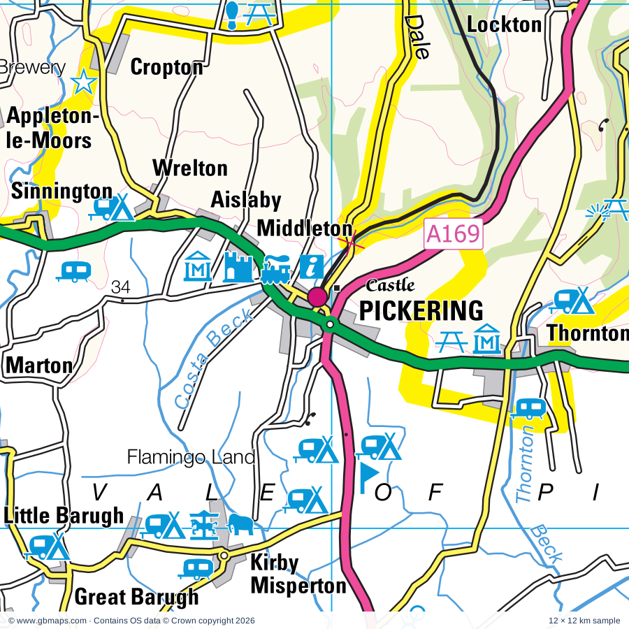
Pickering regional road map. Full 60 × 60 km PDF, SVG and Illustrator files, with a free PDF sample.

GBMAPS.COM

Pickering Regional Road Map

Call Us Now for Help01751 473136

GREAT BRITAIN ROAD ATLAS · 1:250,000 RY-44

Pickering & surrounding area

Explore the full 60 × 60 km Pickering regional road map at 1:250,000, covering Pickering, Malton, Scarborough, York, Driffield. Compare the complete coverage below; a detailed PDF sample is available free.

PICKERING & SURROUNDING AREAREGIONAL ROAD MAP
60 × 60 km · Full map previewDownload the free SVG ↓

INSIDE THE FULL 60 × 60 KM MAP

Explore the Pickering map area

1:250,000 cartography

Towns, villages & places

More mapped places (216)
  • Wilton
  • Wrelton
  • Brawby
  • Butterwick
  • Marton
  • Scampston
  • Broughton
  • Rillington
  • Swinton
  • Sinnington
  • Scagglethorpe
  • Amotherby
  • Allerston
  • Salton
  • East Knapton
  • Yedingham
  • Settrington
  • Ebberston
  • Great Edstone
  • Cropton
  • Lockton
  • Wintringham
  • Keldholme
  • Muscoates
  • Levisham
  • Slingsby
  • Snainton
  • Stape
  • Fryton
  • High Hutton
  • Coneysthorpe
  • Spaunton
  • Lastingham
  • East Heslerton
  • Langton
  • Nunnington
  • Wombleton
  • Hovingham
  • Kennythorpe
  • Stonegrave
  • Ganthorpe
  • Birdsall
  • Sawdon
  • Duggleby
  • Nawton
  • Burythorpe
  • Gillamoor
  • Beadlam
  • Harome
  • Westow
  • Kirkham
  • Fadmoor
  • Bulmer
  • Cawton
  • Terrington
  • Sherburn
  • Kirby Grindalythe
  • Crambe
  • Wykeham
  • Scackleton
  • Leavening
  • Pockley
  • Coulton
  • Oswaldkirk
  • East Lutton
  • Foston
  • Helperthorpe
  • Howsham
  • Acklam
  • Broxa
  • Sproxton
  • Thorgill
  • Ganton
  • Weaverthorpe
  • West Ayton
  • Leppington
  • Thixendale
  • Skewsby
  • Everley
  • East Ayton
  • Whenby
  • Hackness
  • Carlton
  • Sledmere
  • Harton
  • Silpho
  • Stearsby
  • Bossall
  • Willerby
  • Scrayingham
  • Butterwick
  • Flaxton
  • Suffield
  • Irton
  • Goathland
  • Fimber
  • Ampleforth
  • Seamer
  • Church Houses
  • Yearsley
  • Staxton
  • Fridaythorpe
  • Bugthorpe
  • Farlington
  • Beck Hole
  • Foxholes
  • Brandsby
  • Claxton
  • Harwood Dale
  • Rievaulx
  • Buttercrambe
  • Scalby
  • Skirpenbeck
  • Flixton
  • Wass
  • Youlthorpe
  • Wetwang
  • Burniston
  • Stillington
  • Langtoft
  • Fordon
  • Scawton
  • Strensall
  • Grosmont
  • Glaisdale
  • Crayke
  • Street
  • Cloughton
  • Old Byland
  • Folkton
  • Cockayne
  • Oulston
  • Huggate
  • Littlebeck
  • Egton
  • Staintondale
  • Coxwold
  • Thwing
  • Oldstead
  • Fangfoss
  • Huby
  • Towthorpe
  • Meltonby
  • Warthill
  • Ravenscar
  • Bolton
  • Lealholm
  • Lebberston
  • Yapham
  • Sneaton Thorpe
  • Sleights
  • Millington
  • Ugglebarnby
  • Kilburn
  • Fylingthorpe
  • Houlsyke
  • Holtby
  • Raw
  • Husthwaite
  • Earswick
  • Gristhorpe
  • Aislaby
  • Elmswell
  • Sneaton
  • Tibthorpe
  • Westerdale
  • Robin Hood's Bay
  • Wigginton
  • Muston
  • Ainthorpe
  • Hunmanby
  • Wilberfoss
  • Castleton
  • Danby
  • Huntington
  • Dunnington
  • Hawsker
  • Warter
  • Little Driffield
  • Stainsacre
  • Kilham
  • Kirkburn
  • Kexby
  • Eastburn
  • North Dalton
  • New Earswick
  • Chop Gate
  • Murton
  • Kelleythorpe
  • Urra
  • Southburn
  • Rudston
  • Ruston Parva
  • Bainton
  • Tollerton
  • Shipton
  • Skelton
  • Nafferton
  • Harpham
  • Lowthorpe
  • Heslington
  • Battersby
  • Skerne
  • Beningbrough
  • Wansford
  • Kildale
  • Easby
  • Knapton
  • Kirkby
  • Great Busby
  • Brigham
  • Hessay
  • Rotsea
  • Rufforth
  • Stokesley
  • Hempholme

Roads across this sheet

A19, A59, A64, A164, A165, A166, A169, A170, A171, A172, A173, A614, A1036, A1039, A1079, A1237, B1224, B1227, B1228, B1246, B1248, B1249, B1251, B1252

More road numbers

B1253, B1257, B1258, B1261, B1363, B1364, B1365, B1410, B1415, B1416, B1427, B1447

Rivers & waterways

Costa Beck, Driffield Canal, Frodingham Beck, Gypsey Race, Hodge Beck, Kelk Beck, Old Howe, River Derwent, River Dove, River Esk, River Hertford, River Hull

More waterways

River Leven, River Nidd, River Ouse, River Riccal, River Rye, River Seph, River Seven, Thornton Beck

Landmarks & landscape

Ampleforth Abbey, Amplethorpe College, Beck Hole, Beck Isle Museum of Rural Life, Bedern Hall, Fairfax House, Grand Assembly Rooms, Merchant Taylors' Hall, St Anthony's Hall, Mansion House, Beningbrough Hall, Boggle Hole, Bridestones Nature Reserve, Burton Agnes Hall, Burton Agnes Hall Garden, Byland Abbey, Byland Abbey (remains of), NORTH YORK MOORS NATIONAL PARK

More named features

Castle Howard, Castle Howard Arboretum, Cawthorne Roman Camps, Centre for Early Music, The Psychic Museum, City of Troy (Turf Maze), Clarence Gardens, Clifford's Tower, Coxwold Pottery, Cropton Brewery and Visitor Centre, Dalby Forest Drive, Danelaw Dark Age Village, Deerholme Pottery, Derwent Valley Light Railway, Duggleby Howe, Duncombe Park, Ebberston Hall, Eden Camp, Esk Leisure, Falling Foss, Flamingo Land, Forge Valley Woods, Gilling Castle, Go Ape Dalby, Helmsley Castle, Helmsley Walled Garden, Hob Hole, Hunt House, Impressions Gallery, York City Art Gallery, Merchant Adventurers' Hall, York Brewery Tour, York Observatory, International Centre for Birds of Prey, Keldy Castle, Kilburn White Horse, Kilburn White Horse (Hill Figure), Kinderland, Kirkham Priory, Kirkham Priory (remains of), Langdale Quest, Levisham Moor, Lilla Cross, Lord Stones Country Park, Luna Park, Mallyan Spout, Marton Abbey, Millennium Stone, Millington Wood Nature Reserve, Moorland Wood, Mouseman Visitor Centre, Newburgh Priory, North Yorkshire Moors Railway, North Yorkshire Motor Museum, Northstead Manor Gardens, Nunnington Hall, Old Coastguard Station, Old Coastguard Station Visitor Centre, Peasholm Park, Pickering Castle, Playdale Farm Park, ROMAN CAMP, Ralph Crosses, Rawcliffe Bar Country Park, Regimental Museum, Richard 111 Museum, York Dungeon, York Story, Barley Hall, Rievaulx Abbey, Rievaulx Terrace and Temples, Robin Hood's Bay Museum, Music in Miniature Exhibition, Rotunda Museum, Old Mill Toy Museum and Tea Rooms, Wood End Museum, Rudston Monolith, Ryedale Folk Museum, Scampston Hall, Scampston Hall and Gardens, Scarborough Art Gallery, Central Tramway Cliff Lift, Scarborough Castle, Scarborough Millennium Heritage Centre, Anne Bronte's Grave, Terror Tower, Sea Life Centre, Shandy Hall, Sheriff Hutton Castle, Sledmere House, South Cliff Gardens, Holbeck Gardens, Spout House (The Original Sun Inn), St William's College, Stained Glass Centre, Staitondale Shire Horse Farm, Sutton Bank National Park Centre, Sutton Park, The Betton Farm Visitor Centre, The Grainary Wildlife Farm, The Mere, The Moors National Park Centre, Trailways Visitor Centre, Treasurer's House, Wain Stones, Wharram Percy Deserted Medieval Village, Wharram Percy Village, Wheeldale Roman Road, Whitwell-on-the-Hill Point to Point Racecourse, Willy Howe, Wykeham Lakes, York Castle, York Cold War Bunker, York Minster, St Mary's Abbey, York Minster, Treasurer's House, Yorkshire Lavender, Yorkshire Museum of Farming, Yorkshire Museum, National Railway Museum, Bar Convent Museum, Jorvick, Micklegate Bar Museum, The Arc
Local authority & parish coverage

Wholly or partly within the full map rectangle. These boundaries are coverage information, not additional artwork layers.

  • East Riding of YorkshirePartly within
  • North YorkshirePartly within
  • YorkPartly within
Wards & electoral divisions 54 areas
  • Acomb Ward
  • Beverley Rural Ward (part)
  • Clifton Ward
  • Driffield and Rural Ward
  • Dringhouses & Woodthorpe Ward (part)
  • East Wolds and Coastal Ward (part)
  • Fishergate Ward (part)
  • Fulford & Heslington Ward (part)
  • Guildhall Ward
  • Haxby & Wigginton Ward
  • Heworth Ward
  • Heworth Without Ward
  • Holgate Ward
  • Hull Road Ward (part)
  • Huntington & New Earswick Ward
  • Micklegate Ward (part)
  • Osbaldwick & Derwent Ward (part)
  • Pocklington Provincial Ward (part)
  • Rawcliffe & Clifton Without Ward
  • Rural West York Ward (part)
  • Strensall Ward
  • Westfield Ward (part)
  • Wolds Weighton Ward (part)
  • Amotherby & Ampleforth ED
  • Castle ED
  • Cayton ED (part)
  • Danby & Mulgrave ED (part)
  • Derwent Valley & Moor ED
  • Easingwold ED (part)
  • Eastfield ED
  • Esk Valley & Coast ED (part)
  • Falsgrave & Stepney ED
  • Great Ayton ED (part)
  • Helmsley & Sinnington ED (part)
  • Hillside & Raskelf ED (part)
  • Huby & Tollerton ED (part)
  • Hunmanby & Sherburn ED (part)
  • Hutton Rudby & Osmotherley ED (part)
  • Kirkbymoorside & Dales ED
  • Malton ED
  • Newby ED
  • Northstead ED
  • Norton ED
  • Ouseburn ED (part)
  • Pickering ED
  • Scalby & the Coast ED
  • Seamer ED
  • Sheriff Hutton & Derwent ED
  • Stokesley ED (part)
  • Thornton Dale & Wolds ED
  • Weaponness & Ramshill ED
  • Whitby Streonshalh ED (part)
  • Whitby West ED (part)
  • Woodlands ED
Civil parishes & communities 281 areas
  • Acklam CP
  • Aislaby CP
  • Aislaby CP
  • Allerston CP
  • Alne CP (part)
  • Amotherby CP
  • Ampleforth CP
  • Angram Grange CP
  • Appleton-le-Moors CP
  • Appleton-le-Street with Easthorpe CP
  • Askham Bryan CP (part)
  • Bainton CP
  • Barmby Moor CP (part)
  • Barton-le-Street CP
  • Barton-le-Willows CP
  • Barugh (Great and Little) CP
  • Beadlam CP
  • Beningbrough CP
  • Beswick CP (part)
  • Bilsdale Midcable CP
  • Birdsall CP
  • Bishop Wilton CP
  • Boltby CP (part)
  • Brandesburton CP (part)
  • Brandsby-cum-Stearsby CP
  • Bransdale CP
  • Brawby CP
  • Brompton CP
  • Broughton CP
  • Broxa-cum-Troutsdale CP
  • Bugthorpe CP
  • Bulmer CP
  • Burniston CP
  • Burton Agnes CP (part)
  • Burton Fleming CP (part)
  • Burythorpe CP
  • Buttercrambe with Bossall CP
  • Byland with Wass CP
  • Carlton CP (part)
  • Carlton Husthwaite CP (part)
  • Catton CP
  • Cawton CP
  • Cayton CP
  • Claxton CP
  • Clifton Without CP
  • Cloughton CP
  • Cold Kirby CP
  • Commondale CP (part)
  • Coneysthorpe CP
  • Cottam CP
  • Coulton CP
  • Coxwold CP
  • Crambe CP
  • Crayke CP
  • Cropton CP
  • Dalby-cum-Skewsby CP
  • Danby CP (part)
  • Darncombe-cum-Langdale End CP
  • Driffield CP
  • Duggleby CP
  • Dunnington CP (part)
  • Earswick CP
  • Easby CP (part)
  • Easingwold CP (part)
  • East Ayton CP
  • Eastfield CP
  • Ebberston and Yedingham CP
  • Edstone CP
  • Egton CP (part)
  • Eskdaleside cum Ugglebarnby CP
  • Faceby CP (part)
  • Fadmoor CP
  • Fangfoss CP
  • Farlington CP
  • Farndale East CP
  • Farndale West CP
  • Fimber CP
  • Flaxton CP
  • Folkton CP
  • Foston CP (part)
  • Foston CP
  • Foxholes CP
  • Fridaythorpe CP
  • Fryton CP
  • Full Sutton CP
  • Fylingdales CP
  • Fylingdales and Hawsker-cum-Stainsacre CP
  • Ganton CP
  • Garton CP
  • Gate Helmsley CP
  • Gillamoor CP
  • Gilling East CP
  • Glaisdale CP (part)
  • Goathland CP
  • Great Ayton CP (part)
  • Great Busby CP
  • Great and Little Broughton CP
  • Grimstone CP
  • Gristhorpe CP (part)
  • Grosmont CP
  • Habton CP
  • Hackness CP
  • Harome CP
  • Harpham CP (part)
  • Hartoft CP
  • Harton CP
  • Harwood Dale CP
  • Hawnby CP (part)
  • Hawsker-cum-Stainsacre CP (part)
  • Haxby CP
  • Helmsley CP
  • Henderskelfe CP
  • Heslerton CP
  • Heslington CP (part)
  • Hessay CP
  • Heworth Without CP
  • Holtby CP
  • Hood Grange CP (part)
  • Hovingham CP
  • Howsham CP
  • Huby CP
  • Huggate CP
  • Hunmanby CP (part)
  • Huntington CP
  • Husthwaite CP (part)
  • Hutton Buscel CP
  • Hutton Cranswick CP
  • Hutton Mulgrave CP (part)
  • Hutton-le-Hole CP
  • Huttons Ambo CP
  • Ingleby Greenhow CP
  • Irton CP
  • Kelk CP (part)
  • Kexby CP (part)
  • Kilburn High and Low CP (part)
  • Kildale CP (part)
  • Kilham CP
  • Kirby Grindalythe CP
  • Kirby Misperton CP
  • Kirby Underdale CP
  • Kirkburn CP
  • Kirkby CP
  • Kirkbymoorside CP
  • Langtoft CP
  • Langton CP
  • Lastingham CP
  • Leavening CP
  • Lebberston CP
  • Levisham CP
  • Lillings Ambo CP
  • Linton-on-Ouse CP (part)
  • Little Ayton CP (part)
  • Little Busby CP (part)
  • Lockton CP
  • Long Marston CP (part)
  • Luttons CP
  • Malton CP
  • Marishes CP
  • Marton CP
  • Marton-cum-Moxby CP
  • Middleton CP (part)
  • Middleton CP
  • Millington CP
  • Moor Monkton CP (part)
  • Murton CP
  • Muston CP (part)
  • Nafferton CP
  • Nawton CP
  • Nether Poppleton CP
  • New Earswick CP
  • Newburgh CP
  • Newby and Scalby CP
  • Newholm-cum-Dunsley CP (part)
  • Newton CP
  • Newton on Derwent CP (part)
  • Newton-on-Ouse CP
  • Normanby CP
  • North Dalton CP (part)
  • North Frodingham CP (part)
  • Norton-on-Derwent CP
  • Nun Monkton CP (part)
  • Nunburnholme CP (part)
  • Nunnington CP
  • Old Byland and Scawton CP
  • Oldstead CP
  • Osbaldwick CP
  • Osgodby CP
  • Oswaldkirk CP
  • Oulston CP
  • Overton CP
  • Pickering CP
  • Pockley CP
  • Pocklington CP (part)
  • Raskelf CP (part)
  • Rawcliffe CP
  • Rievaulx CP
  • Rillington CP
  • Rosedale East Side CP
  • Rosedale West Side CP
  • Rudston CP (part)
  • Rufforth with Knapton CP (part)
  • Salton CP
  • Sand Hutton CP
  • Scackleton CP
  • Scagglethorpe CP
  • Scampston CP
  • Scarborough CP
  • Scrayingham CP
  • Seamer CP
  • Seamer CP (part)
  • Settrington CP
  • Sherburn CP
  • Sheriff Hutton CP
  • Shipton CP
  • Silpho CP
  • Sinnington CP
  • Skelton CP
  • Skerne and Wansford CP
  • Skirpenbeck CP
  • Skutterskelfe CP (part)
  • Sledmere CP
  • Slingsby CP
  • Snainton CP
  • Sneaton CP
  • South Holme CP
  • Spaunton CP
  • Sproxton CP
  • Staintondale CP
  • Stamford Bridge CP
  • Stape CP
  • Stillington CP
  • Stockton-on-the-Forest CP
  • Stokesley CP (part)
  • Stonegrave CP
  • Strensall with Towthorpe CP
  • Suffield-cum-Everley CP
  • Sutton-on-the-Forest CP
  • Sutton-under-Whitestonecliffe CP (part)
  • Swinton CP
  • Terrington CP
  • Thirlby CP (part)
  • Thixendale CP
  • Thormanby CP (part)
  • Thornton-le-Clay CP
  • Thornton-le-Dale CP
  • Thornton-on-the-Hill CP
  • Thorpe Bassett CP
  • Thwing CP
  • Tibthorpe CP
  • Tollerton CP
  • Ugthorpe CP (part)
  • Upper Helmsley CP
  • Upper Poppleton CP
  • Warter CP (part)
  • Warthill CP
  • Watton CP (part)
  • Weaverthorpe CP
  • Welburn CP
  • Welburn CP
  • West Ayton CP
  • Westerdale CP
  • Westow CP
  • Wetwang CP
  • Wharram CP
  • Whenby CP
  • Whitby CP (part)
  • Whitwell-on-the-Hill CP
  • Whorlton CP (part)
  • Wigginton CP
  • Wilberfoss CP
  • Wildon Grange CP (part)
  • Willerby CP
  • Wilton CP
  • Wintringham CP
  • Wold Newton CP
  • Wombleton CP
  • Wrelton CP
  • Wykeham CP
  • Yapham CP
  • Yearsley CP
  • Youlton CP (part)

Source: the GBMaps road atlas, OS Boundary-Line and postcode mapping datasets. Source editions are being checked for publication. Unmarked boundary names are wholly within the sheet; “part” means the map edge crosses the area.

Place lists are selected from the map source, not a complete gazetteer. Named features describe the cartography; visitor facilities and opening status are not verified. The free sample covers only 12 × 12 km of this larger sheet.

INSIDE YOUR DOWNLOAD

A proper road map, in useful formats

Road classifications, towns and villages, railways, rivers, landscape detail and tourist symbols, brought together in the GBMaps regional road atlas style.

PDF filePDFSVG fileSVGAdobe Illustrator AI fileAi

PDF for the finished map. SVG and layered Illustrator artwork for adapting colours, adding your own information and preparing designs.

THE FINISHED SHEET

Designed for print and presentation

Map coverage
60 × 60 km
Sample coverage
12 × 12 km
Print layout
A3 landscape · enlarged 1:250k cartography
Sheet furniture
Border, scale bar, key & north arrow

A few useful details

What changes when I select another square?

Select a surrounding square to bring it into the centre and reveal the maps around it. Each square is a different 60 × 60 km map. The preview, free sample and selected download change together. Neighbouring sheets overlap by 30 km so you can choose the coverage that suits you.

Is the free sample a vector map?

The on-page detail is an SVG. The free download is a separate 12 × 12 km PDF with a link to the full map. Please retain its copyright credits and product link when sharing it.

Can I buy a larger combined map?

These downloads are individual ready-made sheets. Contact GBMaps if you need a larger combined area.

FREE PDF SAMPLE

Your free map sample

Your free 12 × 12 km sample includes a link back to this map, so you can return for the full area whenever you need it.

Download free PDF sample ↓

Get your Pickering map

Map download bundle

£24.00including VATOne payment

Pay securely

One payment. Your map stays open.

Your map download

Your map files

Preparing your download…

Checking your private download link…

Your map downloads

Already bought a map?

Find the downloads from your purchases.

Enter the email address you used at checkout. We’ll email you a private link to your available map downloads.