Nottingham regional road map. Full 60 × 60 km PDF, SVG and Illustrator files, with a free PDF sample.

GBMAPS.COM

Nottingham Regional Road Map

Call Us Now for Help01751 473136

GREAT BRITAIN ROAD ATLAS · 1:250,000 GB-450-0360

Nottingham & surrounding area

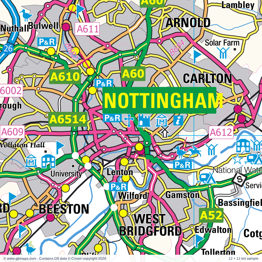
Explore the full 60 × 60 km Nottingham regional road map at 1:250,000, covering Nottingham, Sheffield, Mansfield, Shirebrook, Alfreton. Compare the complete coverage below; a detailed PDF sample is available free.

NOTTINGHAM & SURROUNDING AREAREGIONAL ROAD MAP
60 × 60 km · Full map previewDownload the free SVG ↓

INSIDE THE FULL 60 × 60 KM MAP

Explore the Nottingham map area

1:250,000 cartography

Towns, villages & places

More mapped places (355)
  • Wirksworth
  • Beeston
  • Sandiacre
  • Dronfield
  • Dinnington
  • Bingham
  • Retford
  • Bakewell
  • Skegby
  • Teversal
  • Huthwaite
  • Pleasley
  • Hilcote
  • Rowthorne
  • Tibshelf
  • Pinxton
  • Glapwell
  • Hardstoft
  • Blackwell
  • Selston
  • Newstead
  • Pilsley
  • Westhouses
  • Ravenshead
  • Stonebroom
  • Scarcliffe
  • Palterton
  • Bagthorpe
  • Morton
  • Holmewood
  • Heath
  • Clipstone
  • Rainworth
  • Langwith
  • Linby
  • Somercotes
  • Blidworth
  • Underwood
  • Papplewick
  • Shirland
  • Ironville
  • Brinsley
  • Stretton
  • Higham
  • Kings Clipstone
  • Whaley
  • Swanwick
  • Grassmoor
  • Oakerthorpe
  • Tupton
  • Cuckney
  • Wessington
  • Shuttlewood
  • Pentrich
  • Brackenfield
  • Elmton
  • Duckmanton
  • Wingerworth
  • Norton
  • Holbeck
  • Calow
  • Edwinstowe
  • Alton
  • Fallgate
  • Milltown
  • Creswell
  • Bilsthorpe
  • Farnsfield
  • Oxton
  • Clowne
  • Budby
  • Woodthorpe
  • Ashover
  • Nuthall
  • Awsworth
  • Calverton
  • Heage
  • Fritchley
  • Crich
  • Shipley
  • Bullbridge
  • Kelstedge
  • Brimington
  • Carburton
  • Whitwell
  • Ollerton
  • Hodthorpe
  • Spitewinter
  • Ambergate
  • Edingley
  • Barlborough
  • Lea
  • Eakring
  • Cossall
  • Whatstandwell
  • Kirklington
  • Tansley
  • Holloway
  • Wellow
  • Smalley
  • Woodborough
  • Mapperley
  • Horsley Woodhouse
  • Perlethorpe
  • Kilburn
  • Halam
  • Renishaw
  • Holymoorside
  • Epperstone
  • Spinkhill
  • Riber
  • Boughton
  • Alderwasley
  • Ompton
  • Lambley
  • Horsley
  • Holbrook
  • Kirton
  • Halloughton
  • Old Brampton
  • Trowell
  • Eckington
  • Harthill
  • Cutthorpe
  • Hundall
  • Matlock Bath
  • Kneesall
  • Coxbench
  • Blackbrook
  • Netherthorpe
  • Walesby
  • Milford
  • Rhodesia
  • Winkburn
  • Maplebeck
  • Barlow
  • Killamarsh
  • Bolehill
  • Shottle
  • Unstone
  • Lowdham
  • Wadshelf
  • Normanton
  • Kersall
  • Stanley
  • Apperknowle
  • Morley
  • Carlton
  • Gonalston
  • Hockerton
  • Haughton
  • Bothamsall
  • Shireoaks
  • Dale Abbey
  • Hazelwood
  • Shottlegate
  • Thurgarton
  • Common Side
  • Bonsall
  • Middleton
  • Duffield
  • Wales
  • Laxton
  • Ridgeway
  • Brightgate
  • Bevercotes
  • Wensley
  • Gunthorpe
  • Highlane
  • Hoveringham
  • Bleasby
  • Caythorpe
  • Morton
  • Wilford
  • Shelford
  • Moorhall
  • Windley
  • Woodsetts
  • Breadsall
  • Idridgehay
  • Scofton
  • Upton
  • Todwick
  • Elkesley
  • Millthorpe
  • Caunton
  • Beeley
  • Turnditch
  • Risley
  • Rowsley
  • Milton
  • Fiskerton
  • Gamston
  • Egmanton
  • Holmesfield
  • Hopton
  • Quarndon
  • Robin Hood
  • Ible
  • Kneeton
  • Kirk Ireton
  • Wigthorpe
  • Ockbrook
  • Rolleston
  • Aston
  • Bassingfield
  • Carsington
  • Markham Moor
  • Grangemill
  • Winster
  • Ranby
  • Tuxford
  • Moorhouse
  • Lydgate
  • Staythorpe
  • Gildingwells
  • Ossington
  • Clifton
  • Newton
  • Birchover
  • Gamston
  • Edwalton
  • Biggin
  • Breaston
  • Borrowash
  • Edensor
  • Aughton
  • Averham
  • Aldwark
  • Kedleston
  • Norwell
  • Syerston
  • Draycott
  • Hulland Ward
  • Flintham
  • Mugginton
  • Longcliffe
  • Baslow
  • Letwell
  • Eaton
  • Elton
  • Hodsock
  • Kelham
  • Ulley
  • Babworth
  • Ruddington
  • Brassington
  • Bathley
  • Tollerton
  • Hognaston
  • Pilsley
  • Alport
  • Screveton
  • Askham
  • Thorpe
  • Elston
  • Langold
  • Treeton
  • Elvaston
  • Weston
  • Mercaston
  • Curbar
  • Mackworth
  • Thrumpton
  • Atlow
  • Thurcroft
  • Clipston
  • Youlgreave
  • Plumtree
  • Firbeck
  • Slade Hooton
  • Calver
  • Catcliffe
  • Upton
  • Thulston
  • Blyth
  • Scarrington
  • Cromwell
  • Gotham
  • Bradbourne
  • Sibthorpe
  • Bradmore
  • Headon
  • Ballidon
  • Hawton
  • Shardlow
  • Hawksworth
  • Froggatt
  • Hassop
  • Over Haddon
  • Oldcotes
  • Tithby
  • Darlton
  • Kniveton
  • Grassthorpe
  • Brailsford
  • Torworth
  • Grove
  • Bradley
  • Grindleford
  • Rowland
  • Commonside
  • Keyworth
  • Aslockton
  • Welham
  • East Drayton
  • Ranskill
  • Ednaston
  • Great Longstone
  • Shelton
  • Owthorpe
  • Eyam
  • Lound
  • Lees
  • Stokeham
  • Woodbeck
  • Clarborough
  • Flawborough
  • Orston
  • Longlane
  • Colston Bassett
  • Hayton
  • Shirley
  • Barnstone
  • Thurvaston
  • Langar
  • Hollington
  • Kinoulton
  • Alverton
  • Granby
  • Hathersage
  • Sutton
  • Kilvington
  • Treswell
  • Trusley
  • Burnaston
  • Dalbury
  • Mattersey
  • Rampton
  • Findern
  • Rodsley
  • Longford
  • Clayworth
  • Etwall
  • Wiseton
  • Sturton le Steeple
  • Plungar
  • Bamford
  • Harby
  • Redmile
  • Hilton
  • Stathern
  • Bole
  • Saundby
  • Beckingham

Roads across this sheet

M1, M18, A1(M), A6, A38, A46, A52, A57, A60, A61, A453, A511, A514, A516, A517, A601, A606, A608, A609, A610, A611, A612, A614, A615

More road numbers

A616, A617, A618, A619, A620, A621, A623, A625, A630, A631, A632, A634, A638, A5012, A5111, A5132, A5194, A5250, A6002, A6005, A6007, A6008, A6009, A6011, A6013, A6019, A6020, A6075, A6096, A6097, A6101, A6102, A6109, A6117, A6130, A6135, A6175, A6178, A6187, A6190, A6191, A6192, A6200, A6211, A6464, A6514, A6520, B600, B679, B680, B682, B683, B684, B686, B690, B692, B1164, B1403, B5010, B5020, B5021, B5023, B5035, B5036, B5055, B5056, B5057, B6000, B6001, B6002, B6003, B6004, B6006, B6007, B6008, B6009, B6010, B6011, B6012, B6013, B6014, B6016, B6017, B6018, B6019, B6020, B6021, B6022, B6023, B6024, B6025, B6026, B6027, B6028, B6030, B6031, B6032, B6033, B6034, B6035, B6036, B6038, B6039, B6040, B6041, B6042, B6043, B6044, B6045, B6048, B6050, B6051, B6052, B6053, B6054, B6056, B6057, B6058, B6059, B6060, B6063, B6064, B6065, B6066, B6067, B6068, B6069, B6070, B6071, B6073, B6074, B6075, B6076, B6077, B6079, B6080, B6081, B6082, B6083, B6085, B6139, B6150, B6158, B6166, B6179, B6200, B6253, B6325, B6326, B6374, B6375, B6386, B6387, B6388, B6406, B6407, B6408, B6410, B6417, B6418, B6419, B6420, B6425, B6441, B6461, B6463, B6464, B6521, B6533, B6537, B6540, B6547, B6621

Rivers & waterways

Beeston Canal, Chesterfield Canal, Cromford Canal, Cromford Canal (disused), Dover Beck, Erewash Canal, Fairham Brook, Grantham Canal (disused), Nottingham Canal, Nutbrook Canal (disused), River Amber, River Derwent

More waterways

River Devon, River Don, River Erewash, River Idle, River Leen, River Loxley, River Maun, River Meden, River Noe, River Poulter, River Rother, River Ryton, River Sheaf, River Soar, River Trent, River Wye, Sheffield & Tinsley Canal, Trent & Mersey Canal

Landmarks & landscape

Abbeydale Industrial Museum, Ackwright's Mill, Allestree Park, Amen Corner (Karting), Aston Pottery, Attenborough Gravel Pits Nature Reserve, Barrow Hill Roundhouse, Bassetlaw Museum & Percy Laws Memorial Gallery, Beauchief Abbey (remains of), Belper (World Heritage Site), Bestwood Lodge Country Park, Bestwood Winding Engine House, PEAK DISTRICT NATIONAL PARK

More named features

Beth Shalom Holocaust Visitor Centre, Bishops House Museum, Bolsover Castle, Brewhouse Yard, Museum Of Costume & Textiles, Museum of Nottingham Lace, Green's Mill, Castle Museum & Art Gallery, William Booth Birthplace Museum, Brierley Forest Park, Brierley Forest Visitor Centre, Burntstump Country Park, Calverton Folk Museum, Carsington Water Visitor Centre, Castle, Cathedral of All Saints, Derby, Caudwell's Mill, Chatsworth House, Chesterfield Museum and Art Gallery, City Museum and Art Gallery, Kelham Island Industrial Museum, Sheffield Fire and Police Museum, Sheffield Traditional Heritage Museum, Clowne Linear Park, Clumber Park, Clumber Park & Visitor Centre, Colwick Country Park, Colwick Country Park Nature Reserve, Cotgrave Country Park, Creswell Crags Museum and Archaeology Park, Creswell Crags Visitor Centre, Crich Tramway Village, Cromford (World Heritage Site), Cromford Wharf, DH Lawrence Birthplace Museum, Daneshill Lakes Nature Reserve, Darley Abbey Park, Denby Pottery, Derby Industrial Museum, Derby Museum and Art Gallery, Pickford's House Museum, Derby Heritage Centre, Pickford's House Museum, Derby-Silk Mill (World Heritage Site), Derwent Valley Mills & Visitor Centre (World Heritage Site), Dukes Wood Oil Museum, Durban House Heritage Centre, Dyscarr Wood Nature Reserve, Eaton and Gamston Wood Nature Reserve, Ecclesbourne Valley Railway, Elvaston Castle, Elvaston Castle Nature Reserve, Erewash Museum, Eyam Hall, Eyam Hall Craft Centre, Eyam Moor Stone Circle, Eyam Museum, Eyan Hall, Fairham Brook Nature Reserve, Felley Priory, Ferry Farm, Gedling Country Park, Grassmoor Country Park, Graves Art Gallery, Millennium Galleries, Site Gallery, Sheffield Winter Gardens, Graves Park Animal Farm, Haddon Hall, Hardwick Hall, Hardwick Hall Country Park, Hardwick Old Hall (remains of), Hardwick Park Visitor Centre, Heeley City Farm, Heights of Abraham, Heights of Abraham, High Peak Junction Visitor Centre, Highfields Happy Hens, Hob Hurst's House, Holly Copse Nature Reserve, Holme Pierrepoint Hall, Holme Pierrepont Country Park, National Water Sports Centre & Country Park, Idle Valley Nature Reserve, Kedleston Hall, Langold Country Park, Langwith Whaley Thorns Heritage Centre, Laxton Heritage Museum, Lea Gardens, Leawood Pump House, Leen Valley Country Park, Longshaw Estate, Longshaw Estate Visitor Centre, Making It, Mansfield Museum, Matlock Bath Aquarium, Matlock Farm Park, Mattersey Priory, Matthew Kirtley Museum, Middleton Top Visitor Centre, Midland Railway Centre, Midland Railway Centre Country Park, Mr Straw's House, Museum Of Dolls & Bygone Childhood, NCCL Galleries of Justice, National Stone Centre, National Watersports Centre, Nature Reserve, Naturescape Wild Flower Farm, Newark Castle, Newstead Abbey, Newstead and Annesley Country Park, Nine Ladies (Stone Circle), North Leverton Windmill, Nottingham Castle, Nottingham Racecourse, Nottingham Transport Heritage Centre, Old Hall, Papplewick Pumping Station, Patchings Farm Art Centre, Peak District Museum of Mining, Mason Mills Working Textile Museum, Peak Railway, Poolsbrook Country Park, Portland Park Visitor Centre, Poulter Country Park, Redhouse Stables Working Carriage Museum, Reg Taylor's Swan and Wildfowl Sanctuary, Renishaw Hall, Renishaw Hall Gardens, Ridgeway Craft Centre, Roche Abbey, Rother Valley Country Park Nature Reserve, Rother Valley Country Park Visitor Centre, Royal Crown Derby Visitor Centre, Ruddington Country Park Nature Reserve, Ruddington Village Museum, Ruddington Framework Knitters Museum, Rufford Abbey, Rufford Country Park, Rufford Mill, Rushcliffe Country Park, Seller's Wood Nature Reserve, Shardlow Heritage Centre, Sheffield Botanical Gardens, Sheffield Cathedral, St Marie's Cathedral, Sheffield Manor Lodge and Turret House, Sherwood Forest Art and Craft Centre, Sherwood Forest Country Park, Sherwood Forest Farm Park & Miniature Railway, Sherwood Heath Nature Reserve, Sherwood Pines Forest Park, Sherwood Pines Go Ape, Shipley Country Park, Solar Farm, Southwell Minster, Southwell Racecourse, St Barnabas Cathedral, St Johns Chapel and Heritage Centre, Stainsby Mill, Steeple Grange Light Railway, Sundown Adventureland, Sutton Scarsdale Hall, Tapton Lock Visitor Centre, Teversal Visitor Centre, The Flintham Museum, The Hemlock Stone, The Nottingham Canal Nature Reserve, The Old House Museum, The Queen's Royal Lancers and Nott'shire Yeomanry Museum, The Revolution House Museum, The Round Building, The Walks Of Life Heritage Centre, Museum of the Horse, The Workhouse, Thoresby Gallery, Thoresby Hall, Treswell Wood Nature Reserve, Tropical Butterfly House and Wildlife Centre, Turner Museum of Glass, Tuxford Windmill, Ulley Country Park and Visitor Centre, University of Nottingham, Visitor Centre, Visitor Centre, Heage Windmill, Welbeck Abbey, Wetlands Animal Park, Wheelgate Family Adventure Park, White Post Modern Farm Centre, Winster Market House, Wirksworth Heritage Centre, Wollaton Hall, Wollaton Yard Industrial Museum, Wollaton Hall Natural History Museum, Worksop Priory
Local authority & parish coverage

Wholly or partly within the full map rectangle. These boundaries are coverage information, not additional artwork layers.

  • Amber Valley DistrictWholly within
  • Ashfield DistrictWholly within
  • Bassetlaw DistrictPartly within
  • Bolsover DistrictWholly within
  • Broxtowe DistrictWholly within
  • Chesterfield DistrictWholly within
  • City of DerbyPartly within
  • City of NottinghamWholly within
  • Derbyshire Dales DistrictPartly within
  • Erewash DistrictWholly within
  • Gedling DistrictWholly within
  • High Peak DistrictPartly within
  • Mansfield DistrictWholly within
  • Melton DistrictPartly within
  • Newark and Sherwood DistrictPartly within
  • North East Derbyshire DistrictWholly within
  • North West Leicestershire DistrictPartly within
  • Rotherham DistrictPartly within
  • Rushcliffe DistrictPartly within
  • Sheffield DistrictPartly within
  • South Derbyshire DistrictPartly within
Wards & electoral divisions 357 areas
  • Abbey Hill Ward
  • Abbey Ward
  • Abbey Ward
  • Alfreton Ward
  • Allestree Ward
  • Alport & South West Parishes Ward
  • Alvaston North Ward
  • Alvaston South Ward
  • Annesley & Kirkby Woodhouse Ward
  • Anston & Woodsetts Ward
  • Arboretum Ward
  • Ashbourne North Ward (part)
  • Ashbourne South Ward (part)
  • Ashfields Ward
  • Ashover Ward
  • Aspley Ward
  • Aston & Todwick Ward
  • Aston Ward (part)
  • Attenborough & Chilwell East Ward
  • Aughton & Swallownest Ward
  • Ault Hucknall Ward
  • Awsworth Road Ward
  • Awsworth, Cossall & Trowell Ward
  • Bakewell Ward (part)
  • Bancroft Ward
  • Barlborough Ward
  • Barlow & Holmesfield Ward
  • Basford Ward
  • Beacon Ward (part)
  • Beauchief & Greenhill Ward
  • Beckingham Ward (part)
  • Beeston Central Ward
  • Beeston North Ward
  • Beeston Rylands Ward
  • Beeston West Ward
  • Beighton Ward
  • Belper East Ward
  • Belper North Ward
  • Belper South Ward
  • Berridge Ward
  • Berry Hill Ward
  • Bestwood St. Albans Ward
  • Bestwood Ward
  • Bilborough Ward
  • Bilsthorpe Ward
  • Bingham North Ward
  • Bingham South Ward
  • Birley Ward
  • Blackwell Ward
  • Blagreaves Ward
  • Blyth Ward (part)
  • Bolsover East Ward
  • Bolsover North & Shuttlewood Ward
  • Bolsover South Ward
  • Bonsall & Winster Ward (part)
  • Boston Castle Ward (part)
  • Bottesford Ward (part)
  • Boughton Ward
  • Bradwell Ward (part)
  • Brailsford Ward (part)
  • Bramcote Ward
  • Brampton & Walton Ward
  • Brampton East & Boythorpe Ward
  • Brampton West & Loundsley Green Ward
  • Breaston Ward
  • Brick Kiln Ward
  • Bridge Ward (part)
  • Brimington North Ward
  • Brimington South Ward
  • Brinsley Ward
  • Brinsworth Ward (part)
  • Brockwell Ward
  • Broomhill & Sharrow Vale Ward
  • Bulwell Forest Ward
  • Bulwell Ward
  • Bunny Ward (part)
  • Burngreave Ward (part)
  • Calver & Longstone Ward (part)
  • Calverton Ward
  • Carlton Hill Ward
  • Carlton Ward
  • Carlton Ward
  • Carr Bank Ward
  • Carsic Ward
  • Castle Donington Central Ward (part)
  • Castle Ward
  • Castle Ward (part)
  • Cavendish Ward
  • Central Ward
  • Chaddesden East Ward
  • Chaddesden North Ward
  • Chaddesden West Ward
  • Chatsworth Ward
  • Chellaston & Shelton Lock Ward (part)
  • Chilwell West Ward
  • City Ward
  • Clay Cross North Ward
  • Clay Cross South Ward
  • Clayworth Ward (part)
  • Clifton East Ward
  • Clifton West Ward
  • Clowne East Ward
  • Clowne West Ward
  • Coal Aston Ward
  • Codnor, Langley Mill & Aldercar Ward
  • Collingham Ward (part)
  • Colwick Ward
  • Compton Acres Ward
  • Coppice Ward
  • Cotgrave Ward
  • Cotmanhay Ward
  • Cranmer Ward
  • Crich & South Wingfield Ward
  • Cromford & Matlock Bath Ward
  • Crookes & Crosspool Ward
  • Cropwell Ward
  • Croxton Kerrial Ward (part)
  • Daleacre Hill Ward (part)
  • Dales Ward
  • Darley Dale Ward
  • Darley Ward
  • Darnall Ward (part)
  • Daybrook Ward
  • Derby Road East Ward
  • Derby Road West Ward
  • Devon Ward (part)
  • Dinnington Ward (part)
  • Dore & Totley Ward
  • Dovedale, Parwich & Brassington Ward (part)
  • Dover Beck Ward
  • Draycott & Risley Ward
  • Dronfield North Ward
  • Dronfield South Ward
  • Dronfield Woodhouse Ward
  • Duffield & Quarndon Ward
  • Dumbles Ward
  • Dunston Ward
  • Eakring Ward
  • East Bridgford Ward
  • East Markham Ward
  • East Retford East Ward
  • East Retford North Ward
  • East Retford South Ward
  • East Retford West Ward
  • Eastwood Hall Ward
  • Eastwood Hilltop Ward
  • Eastwood St. Mary's Ward
  • Ecclesall Ward
  • Eckington North Ward
  • Eckington South & Renishaw Ward
  • Edwalton Ward
  • Edwinstowe & Clipstone Ward
  • Elmton-with-Creswell Ward
  • Ernehale Ward
  • Etwall Ward (part)
  • Everton Ward (part)
  • Farndon & Fernwood Ward (part)
  • Farnsfield Ward
  • Fulwood Ward
  • Gamston Ward
  • Gedling Ward
  • Gleadless Valley Ward
  • Gosforth Valley Ward
  • Gotham Ward (part)
  • Grange Farm Ward
  • Grassmoor Ward
  • Graves Park Ward
  • Greasley Ward
  • Greenwood & Summit Ward
  • Hallam Fields Ward
  • Hasland Ward
  • Hathersage Ward (part)
  • Hatton Ward (part)
  • Heage & Ambergate Ward
  • Heanor East Ward
  • Heanor West & Loscoe Ward
  • Hillsborough Ward (part)
  • Hilton Ward (part)
  • Holly Forest Town Ward
  • Holmewood & Heath Ward
  • Hope Valley Ward (part)
  • Hornby Ward
  • Hucknall Central Ward
  • Hucknall North Ward
  • Hucknall South Ward
  • Hucknall West Ward
  • Hulland Ward
  • Huthwaite & Brierley Ward
  • Hyson Green & Arboretum Ward
  • Ironville & Riddings Ward
  • Jacksdale & Westwood Ward
  • Keyworth & Wolds Ward (part)
  • Kilburn, Denby, Holbrook & Horsley Ward
  • Killamarsh East Ward
  • Killamarsh West Ward
  • Kimberley Ward
  • Kings Walk Ward
  • Kingsway Forest Town Ward
  • Kingsway Ward
  • Kirk Hallam & Stanton-by-Dale Ward
  • Kirkby Cross & Portland Ward
  • Lady Bay Ward
  • Langold Ward
  • Langwith Ward
  • Larklands Ward
  • Larwood Ward
  • Leamington Ward
  • Leen Valley Ward
  • Lenton & Wollaton East Ward
  • Linacre Ward
  • Lindhurst Ward
  • Ling Forest Ward
  • Little Eaton & Stanley Ward
  • Little Hallam Ward
  • Littleover Ward
  • Long Clawson and Stathern Ward (part)
  • Long Eaton Central Ward
  • Lowdham Ward
  • Lutterell Ward
  • Mackworth & New Zealand Ward
  • Maltby East Ward (part)
  • Manor Castle Ward
  • Manor Ward
  • Mapperley Ward
  • Market Warsop Ward
  • Matlock East & Tansley Ward
  • Matlock West Ward
  • Maun Valley Forest Town Ward
  • Meadows Ward
  • Meden Ward
  • Mickleover Ward
  • Mill Lane Ward
  • Mosborough Ward
  • Muskham Ward (part)
  • Musters Ward
  • Nether Edge & Sharrow Ward
  • Netherfield Ward
  • Netherfield Ward
  • Nevile & Langar Ward (part)
  • Newlands Forest Town Ward
  • Newstead Abbey Ward
  • Newton Ward
  • Norbury Ward (part)
  • Normanton Ward
  • North Wingfield Central Ward
  • Nottingham Road Ward
  • Nuthall East & Strelley Ward
  • Oak Tree Ward
  • Oakham Ward
  • Oakwood Ward
  • Ockbrook & Borrowash Ward
  • Ollerton Ward
  • Park & Arbourthorne Ward
  • Park Hall Ward
  • Penniment Ward
  • Phoenix Ward
  • Pilsley & Morton Ward
  • Pinxton Ward
  • Plains Ward
  • Pleasley Ward
  • Porchester Ward
  • Racecourse Ward
  • Radcliffe on Trent Ward
  • Radford Ward
  • Rainworth North & Rufford Ward
  • Rainworth South & Blidworth Ward
  • Rampton Ward (part)
  • Ranskill Ward (part)
  • Redhill Ward
  • Richmond Ward
  • Ridgeway & Marsh Lane Ward
  • Ripley & Marehay Ward
  • Ripley Ward
  • Rock Hill Ward
  • Rother Vale Ward
  • Rother Ward
  • Ruddington Ward
  • Rufford Ward
  • Sandiacre Ward
  • Sawley Ward
  • Selston Ward
  • Sherwood Ward
  • Sherwood Ward
  • Shipley View Ward
  • Shirebrook North Ward
  • Shirebrook South Ward
  • Shirland Ward
  • Sinfin & Osmaston Ward
  • Sitwell Ward (part)
  • Skegby Ward
  • Smalley, Shipley & Horsley Woodhouse Ward
  • Somercotes Ward
  • South Normanton East Ward
  • South Normanton West Ward
  • Southwell Ward
  • Southwell Ward
  • Spire Ward
  • Spondon Ward
  • St. Ann's Ward
  • Stannington Ward (part)
  • Stanton Hill & Teversal Ward
  • Stapleford North Ward
  • Stapleford South East Ward
  • Stapleford South West Ward
  • Staveley Central Ward
  • Staveley North Ward
  • Staveley South Ward
  • Stenson Ward (part)
  • Sturton Ward (part)
  • Sutton Central & New Cross Ward
  • Sutton Junction & Harlow Wood Ward
  • Sutton St. Mary's Ward
  • Sutton Ward
  • Sutton Ward
  • Sutton-on-Trent Ward (part)
  • Swanwick Ward
  • The Dales Ward
  • Thompsons Ward
  • Thurcroft & Wickersley South Ward (part)
  • Tibshelf Ward
  • Tollerton Ward
  • Toton & Chilwell Meadows Ward
  • Trent Bridge Ward
  • Trent Valley Ward
  • Trent Ward
  • Tupton Ward
  • Tuxford and Trent Ward (part)
  • Underwood Ward
  • Unstone Ward
  • Vale Ward
  • Wainwright Ward
  • Wales Ward
  • Walkley Ward
  • Walton Ward
  • Warsop Carrs Ward
  • Watnall & Nuthall West Ward
  • Welbeck Ward
  • West Bank Ward
  • West Hallam & Dale Abbey Ward
  • Whittington Moor Ward
  • Whittington Ward
  • Whitwell Ward
  • Willington and Findern Ward (part)
  • Wilsthorpe Ward
  • Wingerworth Ward
  • Wirksworth Ward
  • Wollaton West Ward
  • Woodhouse Ward
  • Woodthorpe Ward
  • Worksop East Ward
  • Worksop North East Ward
  • Worksop North Ward
  • Worksop North West Ward
  • Worksop South East Ward
  • Worksop South Ward
  • Yeoman Hill Ward
  • Youlgrave Ward (part)
Civil parishes & communities 422 areas
  • Abney and Abney Grange CP (part)
  • Aldercar and Langley Mill CP
  • Alderwasley CP
  • Aldwark CP
  • Alfreton CP
  • Alkmonton CP (part)
  • Alverton CP (part)
  • Annesley CP
  • Ash CP
  • Ashford in the Water CP (part)
  • Ashleyhay CP
  • Ashover CP
  • Askham CP
  • Aslockton CP
  • Aston cum Aughton CP
  • Aston upon Trent CP (part)
  • Atlow CP
  • Ault Hucknall CP
  • Averham CP
  • Awsworth CP
  • Babworth CP
  • Bakewell CP (part)
  • Ballidon CP (part)
  • Bamford CP (part)
  • Barlborough CP
  • Barlow CP
  • Barnby Moor CP
  • Barrow upon Trent CP (part)
  • Barton Blount CP (part)
  • Barton in Fabis CP
  • Baslow and Bubnell CP
  • Bathley CP
  • Bearwardcote CP
  • Beckingham CP (part)
  • Beeley CP
  • Belper CP
  • Bestwood Village CP
  • Bevercotes CP
  • Biggin CP
  • Bilsthorpe CP
  • Bingham CP
  • Birchover CP
  • Blackwell CP
  • Bleasby CP
  • Blidworth CP
  • Blyth CP (part)
  • Bole CP (part)
  • Bonsall CP
  • Bothamsall CP
  • Bottesford CP (part)
  • Brackenfield CP
  • Bradbourne CP (part)
  • Bradfield CP (part)
  • Bradley CP (part)
  • Bradmore CP
  • Brailsford CP
  • Brampton CP
  • Brassington CP (part)
  • Breadsall CP
  • Breaston CP
  • Brimington CP
  • Brinsley CP
  • Brinsworth CP (part)
  • Brough and Shatton CP (part)
  • Bulcote CP
  • Bunny CP (part)
  • Burnaston CP (part)
  • Burton Joyce CP
  • Callow CP
  • Calow CP
  • Calver CP
  • Calverton CP
  • Car Colston CP
  • Carburton CP
  • Carlton in Lindrick CP
  • Carlton-on-Trent CP (part)
  • Carsington CP
  • Castle Donington CP (part)
  • Catcliffe CP
  • Caunton CP
  • Caythorpe CP
  • Chatsworth CP
  • Church Broughton CP (part)
  • Clarborough and Welham CP
  • Clawson, Hose and Harby CP (part)
  • Clay Cross CP
  • Clayworth CP
  • Clipston CP
  • Clipstone CP
  • Clowne CP
  • Clumber and Hardwick CP
  • Codnor CP
  • Colston Bassett CP (part)
  • Colwick CP
  • Cossall CP
  • Cotgrave CP
  • Cotham CP (part)
  • Crich CP
  • Cromford CP
  • Cromwell CP (part)
  • Cropwell Bishop CP
  • Cropwell Butler CP
  • Croxton Kerrial CP (part)
  • Curbar CP
  • Dalbury Lees CP
  • Dale Abbey CP
  • Darley Dale CP
  • Darlton CP
  • Deer Park CP
  • Denby CP
  • Derwent CP (part)
  • Dethick, Lea and Holloway CP
  • Dinnington St. John's CP
  • Draycott and Church Wilne CP
  • Dronfield CP
  • Duffield CP
  • Dunham-on-Trent CP (part)
  • Eakring CP
  • East Bridgford CP
  • East Drayton CP
  • East Markham CP
  • East Stoke CP
  • Eastwood CP
  • Eaton CP (part)
  • Eaton CP
  • Eckington CP
  • Edensor CP
  • Edingley CP
  • Edlaston and Wyaston CP (part)
  • Edwinstowe CP
  • Egginton CP (part)
  • Egmanton CP
  • Elkesley CP
  • Elmton with Creswell CP
  • Elston CP
  • Elton CP
  • Elton-on-the-Hill CP
  • Elvaston CP
  • Epperstone CP
  • Etwall CP (part)
  • Everton CP (part)
  • Eyam CP (part)
  • Fairham CP
  • Farndon CP
  • Farnsfield CP
  • Felley CP
  • Findern CP (part)
  • Firbeck CP
  • Fiskerton cum Morton CP
  • Flawborough CP
  • Fledborough CP (part)
  • Flintham CP
  • Foolow CP (part)
  • Foston and Scropton CP (part)
  • Froggatt CP
  • Gamston CP
  • Gamston CP
  • Gildingwells CP
  • Glapwell CP
  • Gonalston CP
  • Gotham CP (part)
  • Granby CP
  • Grassmoor, Hasland and Winsick CP
  • Grassthorpe CP (part)
  • Gratton CP (part)
  • Greasley CP
  • Great Longstone CP (part)
  • Grindleford CP
  • Gringley on the Hill CP (part)
  • Grove CP
  • Gunthorpe CP
  • Halam CP
  • Halloughton CP
  • Harthill CP
  • Harthill with Woodall CP
  • Hassop CP
  • Hathersage CP
  • Hatton CP (part)
  • Haughton CP
  • Hawksworth CP
  • Hawton CP (part)
  • Hayton CP
  • Hazelwood CP
  • Headon cum Upton CP
  • Heanor and Loscoe CP
  • Heath and Holmewood CP
  • Hickling CP (part)
  • Highlow CP
  • Hilton CP (part)
  • Hockerton CP
  • Hodsock CP
  • Hodthorpe and Belph CP
  • Hognaston CP
  • Holbrook CP
  • Hollington CP
  • Holme CP (part)
  • Holme Pierrepont CP
  • Holmesfield CP
  • Holymoorside and Walton CP
  • Hoon CP (part)
  • Hopton CP
  • Hopwell CP
  • Horsley CP
  • Horsley Woodhouse CP
  • Hoveringham CP
  • Hulland CP
  • Hulland Ward CP
  • Ible CP
  • Idridgehay and Alton CP
  • Ironville CP
  • Ivonbrook Grange CP
  • Kedleston CP
  • Kelham CP
  • Kersall CP
  • Keyworth CP (part)
  • Kilburn CP
  • Killamarsh CP
  • Kilvington CP (part)
  • Kimberley CP
  • Kings Clipstone CP
  • Kinoulton CP (part)
  • Kirk Ireton CP
  • Kirk Langley CP
  • Kirklington CP
  • Kirton CP
  • Kneesall CP
  • Kneeton CP
  • Kniveton CP (part)
  • Lambley CP
  • Laneham CP (part)
  • Langar cum Barnstone CP
  • Langwith CP
  • Laughton-en-le-Morthen CP (part)
  • Laxton and Moorhouse CP
  • Letwell CP
  • Linby CP
  • Lindhurst CP
  • Little Eaton CP
  • Lockington-Hemington CP (part)
  • Longford CP (part)
  • Lound CP
  • Lowdham CP
  • Mackworth CP
  • Maltby CP (part)
  • Maplebeck CP
  • Mapperley CP
  • Marnham CP (part)
  • Marston on Dove CP (part)
  • Matlock Bath CP
  • Matlock Town CP
  • Mattersey CP (part)
  • Mercaston CP
  • Middleton CP
  • Middleton and Smerrill CP (part)
  • Morley CP
  • Morton CP
  • Nether Haddon CP
  • Nether Langwith CP
  • Newark CP (part)
  • Newstead CP
  • Newton CP
  • Normanton on Trent CP (part)
  • Normanton on the Wolds CP
  • North Leverton with Habblesthorpe CP (part)
  • North Muskham CP (part)
  • North Wingfield CP
  • North and South Anston CP
  • North and South Wheatley CP
  • Northwood and Tinkersley CP
  • Norton, Cuckney, Holbeck and Welbeck CP
  • Norwell CP
  • Nuthall CP
  • Ockbrook and Borrowash CP
  • Offcote and Underwood CP (part)
  • Offerton CP
  • Old Bolsover CP
  • Ollerton and Boughton CP
  • Ompton CP
  • Orgreave CP
  • Orston CP
  • Osleston and Thurvaston CP
  • Osmaston CP (part)
  • Ossington CP
  • Over Haddon CP (part)
  • Owthorpe CP
  • Oxton CP
  • Papplewick CP
  • Pentrich CP
  • Perlethorpe cum Budby CP
  • Pilsley CP
  • Pilsley CP
  • Pinxton CP
  • Pleasley CP
  • Plumtree CP
  • Quarndon CP
  • Radbourne CP
  • Radcliffe on Trent CP
  • Ragnall CP (part)
  • Rainworth CP
  • Rampton and Woodbeck CP (part)
  • Ranskill CP
  • Ratcliffe on Soar CP (part)
  • Ravensdale Park CP
  • Ravenshead CP
  • Redmile CP (part)
  • Rhodesia CP
  • Ripley CP
  • Risley CP
  • Rodsley CP (part)
  • Rolleston CP
  • Rowland CP
  • Rowsley CP
  • Ruddington CP
  • Rufford CP
  • Sandiacre CP
  • Saundby CP (part)
  • Sawley CP
  • Saxondale CP
  • Scarcliffe CP
  • Scarrington CP
  • Screveton CP
  • Scrooby CP (part)
  • Selston CP
  • Shardlow and Great Wilne CP (part)
  • Shelford CP
  • Shelton CP
  • Shipley CP
  • Shirebrook CP
  • Shireoaks CP
  • Shirland and Higham CP
  • Shirley CP (part)
  • Shottle and Postern CP
  • Sibthorpe CP
  • Smalley CP
  • Somercotes CP
  • South Darley CP
  • South Leverton CP (part)
  • South Muskham CP (part)
  • South Normanton CP
  • South Wingfield CP
  • Southwell CP
  • St. Albans CP
  • Stanley and Stanley Common CP
  • Stanton CP
  • Stanton by Dale CP
  • Stanton on the Wolds CP (part)
  • Stapleford CP
  • Stathern CP (part)
  • Staunton CP (part)
  • Staveley CP
  • Staythorpe CP
  • Stenson Fields CP (part)
  • Stoke Bardolph CP
  • Stokeham CP
  • Stoney Middleton CP (part)
  • Stretton CP
  • Sturton Le Steeple CP (part)
  • Styrrup with Oldcotes CP (part)
  • Sutton CP
  • Sutton cum Duckmanton CP
  • Sutton on the Hill CP
  • Sutton-on-Trent CP (part)
  • Swanwick CP
  • Swarkestone CP (part)
  • Syerston CP
  • Tansley CP
  • Temple Normanton CP
  • Thornhill CP (part)
  • Thoroton CP
  • Thorpe CP
  • Thorpe Salvin CP
  • Thrumpton CP (part)
  • Thurcroft CP (part)
  • Thurgarton CP
  • Tibshelf CP
  • Tissington and Lea Hall CP (part)
  • Tithby CP
  • Todwick CP
  • Tollerton CP
  • Torworth CP
  • Treeton CP
  • Treswell CP (part)
  • Trowell CP
  • Trusley CP
  • Tupton CP
  • Turnditch CP
  • Tuxford CP
  • Twyford and Stenson CP (part)
  • Ulley CP
  • Unstone CP
  • Upper Saxondale CP
  • Upton CP
  • Wales CP
  • Walesby CP
  • Wallingwells CP
  • Warsop CP
  • Waverley CP
  • Wellow CP
  • Wessington CP
  • West Burton CP (part)
  • West Drayton CP
  • West Hallam CP
  • West Markham CP
  • Weston CP
  • Weston Underwood CP
  • Whatton-in-the-Vale CP
  • Whiston CP (part)
  • Whitwell CP
  • Wickersley CP (part)
  • Widmerpool CP (part)
  • Willington CP (part)
  • Windley CP
  • Wingerworth CP
  • Winkburn CP
  • Winster CP
  • Wirksworth CP
  • Wiseton CP (part)
  • Wiverton Hall CP
  • Woodborough CP
  • Woodsetts CP
  • Yeldersley CP (part)
  • Youlgreave CP (part)

Source: the GBMaps road atlas, OS Boundary-Line and postcode mapping datasets. Source editions are being checked for publication. Unmarked boundary names are wholly within the sheet; “part” means the map edge crosses the area.

Place lists are selected from the map source, not a complete gazetteer. Named features describe the cartography; visitor facilities and opening status are not verified. The free sample covers only 12 × 12 km of this larger sheet.

INSIDE YOUR DOWNLOAD

A proper road map, in useful formats

Road classifications, towns and villages, railways, rivers, landscape detail and tourist symbols, brought together in the GBMaps regional road atlas style.

PDF filePDFSVG fileSVGAdobe Illustrator AI fileAi

PDF for the finished map. SVG and layered Illustrator artwork for adapting colours, adding your own information and preparing designs.

THE FINISHED SHEET

Designed for print and presentation

Map coverage
60 × 60 km
Sample coverage
12 × 12 km
Print layout
A3 landscape · enlarged 1:250k cartography
Sheet furniture
Border, scale bar, key & north arrow

A few useful details

What changes when I select another square?

Select a surrounding square to bring it into the centre and reveal the maps around it. Each square is a different 60 × 60 km map. The preview, free sample and selected download change together. Neighbouring sheets overlap by 30 km so you can choose the coverage that suits you.

Is the free sample a vector map?

The on-page detail is an SVG. The free download is a separate 12 × 12 km PDF with a link to the full map. Please retain its copyright credits and product link when sharing it.

Can I buy a larger combined map?

These downloads are individual ready-made sheets. Contact GBMaps if you need a larger combined area.

FREE PDF SAMPLE

Your free map sample

Your free 12 × 12 km sample includes a link back to this map, so you can return for the full area whenever you need it.

Download free PDF sample ↓

Get your Nottingham map

Map download bundle

£24.00including VATOne payment

Pay securely

One payment. Your map stays open.

Your map download

Your map files

Preparing your download…

Checking your private download link…

Your map downloads

Already bought a map?

Find the downloads from your purchases.

Enter the email address you used at checkout. We’ll email you a private link to your available map downloads.