North Berwick regional road map. Full 60 × 60 km PDF, SVG and Illustrator files, with a free PDF sample.

GBMAPS.COM

North Berwick Regional Road Map

Call Us Now for Help01751 473136

GREAT BRITAIN ROAD ATLAS · 1:250,000 GB-360-0690

North Berwick & surrounding area

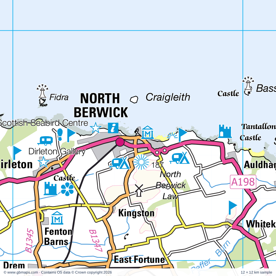
Explore the full 60 × 60 km North Berwick regional road map at 1:250,000, covering East Linton, Pittenweem, Dunbar, Crail, Haddington. Compare the complete coverage below; a detailed PDF sample is available free.

NORTH BERWICK & SURROUNDING AREAREGIONAL ROAD MAP
60 × 60 km · Full map previewDownload the free SVG ↓

INSIDE THE FULL 60 × 60 KM MAP

Explore the North Berwick map area

1:250,000 cartography

Towns, villages & places

More mapped places (101)
  • Tyninghame
  • East Fortune
  • West Barns
  • Gullane
  • Drem
  • St Monans
  • Athelstaneford
  • Traprain
  • Elie
  • Kilrenny
  • Abercrombie
  • Pitcox
  • Earlsferry
  • Broxburn
  • Stenton
  • Spott
  • Ballencrieff
  • Kilconquhar
  • Aberlady
  • Arncroach
  • Carnbee
  • Colinsburgh
  • Spittal
  • Garvald
  • Skateraw
  • Innerwick
  • Drumeldrie
  • Elvingston
  • Longniddry
  • Gladsmuir
  • Kingsbarns
  • Lower Largo
  • Largoward
  • Dunino
  • Bolton
  • Upper Largo
  • Samuelston
  • Stravithie
  • Lathones
  • Gifford
  • Penston
  • Radernie
  • Lawhead
  • Oldhamstocks
  • Macmerry
  • Boarhills
  • Peat Inn
  • New Gilston
  • Woodside
  • Cockburnspath
  • Denhead
  • Baldinnie
  • Windygates
  • Bonnybank
  • Kennoway
  • Ormiston
  • Elphinstone
  • Peaston Bank
  • Leaston
  • Ceres
  • Wallyford
  • Cranshaws
  • Pitscottie
  • Strathkinness
  • Peaston
  • Craigrothie
  • Blebocraigs
  • Humbie
  • Cousland
  • Kemback
  • Kincaple
  • Star
  • Whitecraig
  • Guardbridge
  • Grantshouse
  • Kettlehill
  • Pathhead
  • Osnaburgh
  • Pitlessie
  • Fala
  • Balmalcolm
  • Edgehead
  • Springfield
  • Dewartown
  • Millerhill
  • Kingskettle
  • Kettlebridge
  • Foodieash
  • Crichton
  • Houndwood
  • Danderhall
  • Mayfield
  • Newlandrig
  • Moonzie
  • Newtongrange
  • Letham
  • Gorebridge
  • Auchencrow
  • Reston
  • Luthrie
  • Carrington

Roads across this sheet

A1, A7, A68, A91, A198, A199, A768, A772, A911, A913, A914, A915, A916, A917, A918, A919, A955, A1087, A1107, A1140, A6093, A6094, A6095, A6106

More road numbers

A6112, A6124, A6137, B703, B704, B927, B928, B929, B930, B931, B932, B933, B938, B939, B940, B941, B942, B944, B1343, B1345, B1346, B1347, B1348, B1349, B1361, B1377, B1407, B6355, B6363, B6367, B6368, B6369, B6370, B6371, B6372, B6392, B6414, B6415, B6437, B6438, B6454, B6457, B6458, B6471, B6482, B9129, B9130, B9131, B9171

Rivers & waterways

Ale Water, Biel Water, Birns Water, Bothwell Water, Cameron Burn, Colstoun Water, Dry Burn, Dye Water, Eye Water, Faseny Water, Gifford Water, Hopes Water

More waterways

Monynut Water, Peffer Burn, River Eden, River Esk, River Leven, River North Esk, River Ore, River South Esk, River Tyne, Soonhope Burn, Tyne Water, Whiteadder Water

Landmarks & landscape

Aberlady Bay Nature Reserve, Balcarres House Gardens, Balgonie Castle, British Golf Museum, St Andrews Museum, St Andrews Preservation Trust, Museum of the University of St Andrews, Buckhaven Museum, Cambo Estate Garden, Castle, Chapel, Cheese Company, Coastal Communities Museum, Craigtoun Country Park, Crail Museum & Heritage Centre

More named features

Crail Pottery, Crichton Castle, Dalhousie Castle, Dalkeith Country Park, Dirleton Castle, Dirleton Gallery, Dirleton Garden, Dunglass Church, East Links Family Park, Eden Estuary Centre, Eden Estuary Nature Reserve, Edin's Hall (Broch), Edinburgh Bird of Prey Centre, Edinburgh Butterfly & Insect World, Edinburgh Castle, Fast Castle, Fife Folk Museum, Gladstone's Land, The Georgian House, Glenkinchie Distillery, Gosford House, Griselda Hill Pottery, Hailes Castle, Hill of Tarvit Mansionhouse, Hill of Tarvit Mansionhouse and Garden, Innerwick Castle, Inveresk Lodge Garden, Inwood Garden, John McDouall Stuart Museum, John Muir Birthplace, Dunbar Town Museum, John Muir Country Park, Kellie Castle and Garden, Kilminning Coast Nature Reserve, Kingsbarns Distillary & Visitor Centre, Kirkcaldy Museum and Art Gallery, Lennoxlove House, Levenhall Links Leisure Park, Macduff's Castle, Methil Heritage Centre, Mill, Mouse House Visitor Centre, Museum of Childhood, The Museum of Edinburgh, Dynamic Earth, The Peoples Story, John Knox House, Museum of Scotland, Museum of Fire, Regimental Museum, of The Royal Scots Dragoon Guards, National War Museum of Scotland, Writers' Museum, Musselburgh Racecourse, Myreton Motor Museum, National Flag Heritage Centre, National Museum of Flight, Nature Reserve, Newhailes House, Nunraw Abbey, Old & New Towns Edinburgh (World Heritage Site), Ormiston Cross, Palace of Holyroodhouse, Preston Grange Industrial Heritage Museum, Preston Mill, Preston Tower, Preston Market Cross, Royal Scottish Academy, City Arts Centre, Talbot Rice Gallery, The Hub, The Edinburgh Dungeon, Scotland Secret Bunker, Scotstarvit Tower, Scotstarvit Tower, Barbarafield Riding School, Scottish Archery Centre, Scottish Deer Centre, Scottish Fisheries Museum, Scottish Mining Museum, Scottish National Gallery of Modern Art, Dean Gallery, Scottish National Portrait Gallery, National Gallery of Scotland, Our Dynamic Earth, Scottish Seabird Centre, Seton Collegiate Church (Chapel), Seton House, Chapel, Silverburn House and Park, St Andrews Aquarium, St Andrews Botanic Garden, St Andrews Castle, St Andrews Cathedral, St Martin's Church - ruins, St Mary's Church, St Mary's Cathedral, St Gile's Cathedral, St Mary's Pleasance and Lady Kitty's Garden, St Monans Windmill, St Triduana's Chapel, Tantallon Castle, The Chesters, The Tron, Surgeons Hall Museum, Royal Scots Regimental Museum, Dolls Museum, Torness Power Station Visitor centre, Vogrie Country Park, West Port, Blackfriars Chapel, St Mary on the Rock, St Rule's Tower, St Andrews Precinct Wall and Pends, White Castle Fort, Winton House, Yester Castle, Yester House
Local authority & parish coverage

Wholly or partly within the full map rectangle. These boundaries are coverage information, not additional artwork layers.

  • City of EdinburghPartly within
  • East LothianPartly within
  • FifePartly within
  • MidlothianPartly within
  • Scottish BordersPartly within
Wards & electoral divisions 27 areas
  • Bonnyrigg Ward (part)
  • Buckhaven, Methil and Wemyss Villages Ward (part)
  • Craigentinny/Duddingston Ward (part)
  • Cupar Ward
  • Dalkeith Ward
  • Dunbar and East Linton Ward
  • East Berwickshire Ward (part)
  • East Neuk and Landward Ward
  • Glenrothes Central and Thornton Ward (part)
  • Glenrothes North, Leslie and Markinch Ward (part)
  • Haddington and Lammermuir Ward (part)
  • Howe of Fife and Tay Coast Ward (part)
  • Kirkcaldy East Ward (part)
  • Leaderdale and Melrose Ward (part)
  • Leven, Kennoway and Largo Ward
  • Liberton/Gilmerton Ward (part)
  • Mid Berwickshire Ward (part)
  • Midlothian East Ward (part)
  • Midlothian South Ward (part)
  • Midlothian West Ward (part)
  • Musselburgh Ward
  • North Berwick Coastal Ward
  • Portobello/Craigmillar Ward (part)
  • Preston, Seton and Gosford Ward
  • St. Andrews Ward (part)
  • Tay Bridgehead Ward (part)
  • Tranent, Wallyford and Macmerry Ward
Civil parishes & communities 0 areas

    Source: the GBMaps road atlas, OS Boundary-Line and postcode mapping datasets. Source editions are being checked for publication. Unmarked boundary names are wholly within the sheet; “part” means the map edge crosses the area.

    Place lists are selected from the map source, not a complete gazetteer. Named features describe the cartography; visitor facilities and opening status are not verified. The free sample covers only 12 × 12 km of this larger sheet.

    INSIDE YOUR DOWNLOAD

    A proper road map, in useful formats

    Road classifications, towns and villages, railways, rivers, landscape detail and tourist symbols, brought together in the GBMaps regional road atlas style.

    PDF filePDFSVG fileSVGAdobe Illustrator AI fileAi

    PDF for the finished map. SVG and layered Illustrator artwork for adapting colours, adding your own information and preparing designs.

    THE FINISHED SHEET

    Designed for print and presentation

    Map coverage
    60 × 60 km
    Sample coverage
    12 × 12 km
    Print layout
    A3 landscape · enlarged 1:250k cartography
    Sheet furniture
    Border, scale bar, key & north arrow

    A few useful details

    What changes when I select another square?

    Select a surrounding square to bring it into the centre and reveal the maps around it. Each square is a different 60 × 60 km map. The preview, free sample and selected download change together. Neighbouring sheets overlap by 30 km so you can choose the coverage that suits you.

    Is the free sample a vector map?

    The on-page detail is an SVG. The free download is a separate 12 × 12 km PDF with a link to the full map. Please retain its copyright credits and product link when sharing it.

    Can I buy a larger combined map?

    These downloads are individual ready-made sheets. Contact GBMaps if you need a larger combined area.

    FREE PDF SAMPLE

    Your free map sample

    Your free 12 × 12 km sample includes a link back to this map, so you can return for the full area whenever you need it.

    Download free PDF sample ↓

    Get your North Berwick map

    Map download bundle

    £24.00including VATOne payment

    Pay securely

    One payment. Your map stays open.

    Your map download

    Your map files

    Preparing your download…

    Checking your private download link…

    Your map downloads

    Already bought a map?

    Find the downloads from your purchases.

    Enter the email address you used at checkout. We’ll email you a private link to your available map downloads.