Newcastle upon Tyne regional road map. Full 60 × 60 km PDF, SVG and Illustrator files, with a free PDF sample.

GBMAPS.COM

Newcastle upon Tyne Regional Road Map

Call Us Now for Help01751 473136

GREAT BRITAIN ROAD ATLAS · 1:250,000 GB-420-0570

Newcastle upon Tyne & surrounding area

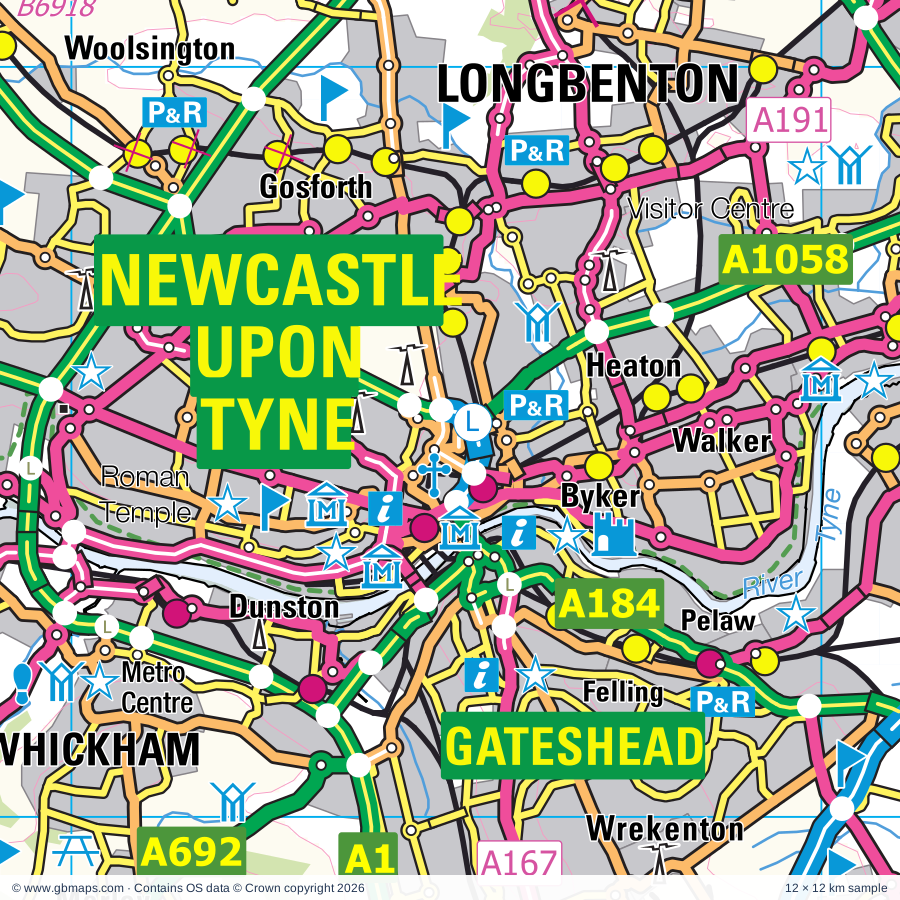
Explore the full 60 × 60 km Newcastle upon Tyne regional road map at 1:250,000, covering Durham, Ponteland, Blaydon, Ryton, Longbenton. Compare the complete coverage below; a detailed PDF sample is available free.

NEWCASTLE UPON TYNE & SURROUNDING AREAREGIONAL ROAD MAP
60 × 60 km · Full map previewDownload the free SVG ↓

INSIDE THE FULL 60 × 60 KM MAP

Explore the Newcastle upon Tyne map area

1:250,000 cartography

Towns, villages & places

More mapped places (187)

Roads across this sheet

A1(M), A68, A167, A167(M), A177, A181, A182, A183, A184, A185, A186, A187, A188, A189, A190, A191, A192, A193, A194, A194(M), A195, A196, A197, A688

More road numbers

A690, A691, A692, A693, A694, A695, A696, A697, A1018, A1052, A1056, A1058, A1061, A1068, A1086, A1108, A1114, A1147, A1148, A1149, A1171, A1172, A1231, A1290, A1300, A6076, A6079, A6085, A6115, A6125, A6127, B143, B601, B1198, B1280, B1283, B1284, B1285, B1286, B1287, B1288, B1291, B1293, B1294, B1296, B1297, B1298, B1299, B1301, B1302, B1303, B1304, B1305, B1306, B1307, B1309, B1311, B1312, B1313, B1314, B1315, B1316, B1317, B1318, B1319, B1320, B1321, B1322, B1325, B1326, B1327, B1328, B1329, B1330, B1331, B1334, B1337, B1344, B1404, B1405, B1426, B1432, B1505, B1516, B1519, B1522, B1523, B1600, B6168, B6173, B6278, B6296, B6301, B6302, B6305, B6306, B6307, B6308, B6309, B6310, B6311, B6312, B6313, B6314, B6315, B6316, B6317, B6318, B6319, B6320, B6321, B6322, B6323, B6324, B6341, B6342, B6343, B6344, B6345, B6395, B6524, B6528, B6529, B6530, B6531, B6532, B6545, B6918

Rivers & waterways

Devil's Water, Fallowlees Burn, River Blyth, River Browney, River Coquet, River Derwent, River Font, River North Tyne, River Pont, River Rede, River South Tyne, River Team

More waterways

River Tyne, River Wansbeck, River Wear

Landmarks & landscape

Abbey, Allensford Country Park, Angel of the North, Anker's House Museum, Arbeia Roman Fort Museum, South Shields Museum and Art Gallery, Aydon Castle, BALTIC The Centre for Contemporary Art, Uni Gallery & Baring Wing, St Mary's Heritage Centre, Barnes Park Nature Trail, Beamish - The North of England Open Air Museum, Bede's World, Bedlington Country Park, Belsay Castle, NORTHUMBERLAND NATIONAL PARK

More named features

Belsay Gardens, Belsay Hall, Benwell Roman Temple, Bessie Surtees House, Blackfriars Museum, Bide-a-Wee Cottage Garden, Big Waters Country Park Nature Reserve, Bill Quay Community Farm, Blue Reef Aquarium, Bolam Lake Country Park, Bowes Railway, Bowes Railway Centre, Brinkburn Priory, Broadwell House, Brockbushes Farm, Broom House Farm, Brunton Turret 26b, CILVRNVM, CORSTOPITVM, Carrycoats Hall, Castle, Castle Keep, Causey Arch, Causey Park, Cherryburn, Chesters Bridge Abutments, Chesters Bridge Abutments, Brunton Turret 26b, Chesters Roman Fort (World Heritage Site), Chesters Roman Fort Museum, Childhood Memories Toy Museum, Corbridge Roman Site, Corbridge Roman Town (World Heritage Site), Crook Hall, Dalden Castle, Denton Hall Turret, Derwent Reservoir, Derwent Walk Country Park, Derwentcote Steel Furnace, Diggerland, Down at the Farm, Druridge Bay Nature Reserve, Durham Castle (World Heritage Site), Durham Cathedral (World Heritage Site), Durham Heritage Centre, Durham Light Infantry Museum, Durham University Oriental Museum, Ebchester Roman Fort, Espley Hall, Finchale Priory, George Stephenson's Cottage, Gibside, Hall, Hancock Museum, Newcastle Discovery Museum, Blackfriars Museum, Laing Art Gallery, The International Centre For Life, Haughton Castle, Heddon-on-the-Wall, Herrington Country Park, Herterton House Gardens, Hetton Lyons Country Park, Hexham Abbey, Hexham Racecourse, Hill Hall Farm, Holy Jesus Hospital, Hylton Castle, James Steel Park, Jesmond Dene, Joe's Pond Nature Reserve, Leas and Marsden Rock, Meldon Park, Monkwearmouth Station Museum, Monument, Moorhouse Wood Nature Reserve, Morpeth Chantry Bagpipe Museum, Morpeth Clock Tower, Museum of Antiquities, National Glass Centre, Newburn Hall Motor Museum, Newburn Tyne Riverside Country Park, Newcastle Racecourse, North East Aircraft Museum, North Tyneside Steam Railway, Northern Gallery for Contemporary Art, Reg Vardy Gallery, Northumberland Cheese Farm, Northumberlandia Visitor Centre, ONNVM, Old Fulling Mill, Museum of Archaeology, Path Head Watermill, Penshaw Monument, Plantrees Roman Wall, Plessey Wood Visitor Centre, Plessey Woods Country Park, Pow Hill Country Park, Prudhoe Castle, QE2 Country Park, Rainton Meadows Visitor Centre, Rising Sun Country Park, Ryhope Engine Museum, Salwell Visitor Centre, Seaton Delaval Hall, Segedunum (World Heritage Site), Segedunum Roman Fort Centre, Shefton Museum of Greek Art & Archaeology, People's Museum of Memorabilia, Hatton Gallery, Shipley Art Gallery, Souter Lighthouse, St Mary's Abbey, St Nicholas's Cathedral, St Paul's Monastery, Stephenson Railway Museum, Sunderland Museum and Winter Gardens, Sunderland Ski Centre, Tanfield Railway, The Arts Centre, The Centre for Life, The Hall, The Highland Cattle Centre, The Old Gaol, Thornley Woodlands Centre, Tyne Green, Tyne Riverside Country Park, Tynemouth Priory, Tynemouth Voluntary Life Brigade Watch House, Tyneside Locomotive Museum, University of Durham Botanical Gardens, VINDOBALA, VINDOMORA, Visitor Centre, Waldridge Fell Country Park, Wallington, Wansbeck Riverside Park, Washington F Pit Museum, Washington Old Hall, Washington Wildfowl and Wetlands Centre, Watergate Forest Park, Whitehouse Farm Centre, Winter's Gibbet, Woodhorn Colliery Museum, Wylam Railway Museum
Local authority & parish coverage

Wholly or partly within the full map rectangle. These boundaries are coverage information, not additional artwork layers.

  • County DurhamPartly within
  • Gateshead DistrictWholly within
  • Newcastle upon Tyne DistrictWholly within
  • North Tyneside DistrictWholly within
  • NorthumberlandPartly within
  • South Tyneside DistrictWholly within
  • Sunderland DistrictWholly within
Wards & electoral divisions 205 areas
  • Arthur's Hill Ward
  • Backworth & Holystone Ward
  • Barnes & Thornhill Ward
  • Battle Hill Ward
  • Beacon & Bents Ward
  • Bede Ward
  • Benwell, Scotswood & Denton Burn Ward
  • Biddick & All Saints Ward
  • Birtley North & Lamesley Ward
  • Birtley South Ward
  • Blakelaw & Cowgate Ward
  • Blaydon Ward
  • Boldon Colliery Ward
  • Bridges Ward
  • Byker Ward
  • Camperdown Ward
  • Castle Ward
  • Chapel Ward
  • Chirton & Percy Main Ward
  • Chopwell & Rowlands Gill Ward
  • Chowdene Ward
  • Cleadon Park & Harton Moor Ward
  • Cleadon Village & East Boldon Ward
  • Crawcrook & Greenside Ward
  • Cullercoats & Whitley Bay South Ward
  • Deckham Ward
  • Dene & South Gosforth Ward
  • Denton & Westerhope Ward
  • Deptford & Hendon Ward
  • Doxford Park Ward
  • Dunston Hill & Whickham East Ward
  • Dunston, Teams & Riverside Ward
  • Elswick Ward
  • Farringdon & Silksworth Ward
  • Fawdon & West Gosforth Ward
  • Fellgate & Hedworth Ward
  • Felling Ward
  • Forest Hall Ward
  • Fulwell Ward
  • Gosforth Ward
  • Grangetown Ward
  • Grindon & Thorney Close Ward
  • Harton Ward
  • Heaton Ward
  • Hebburn North Ward
  • Hebburn South Ward
  • Herrington & Newbottle Ward
  • Hetton Ward
  • High Fell Ward
  • Horsley Hill & Westoe Crown Ward
  • Houghton North Ward
  • Houghton South & Hetton Downs Ward
  • Howdon Ward
  • Hylton Castle Ward
  • Jesmond Ward
  • Kenton Ward
  • Killingworth Ward
  • Kingston Park & Dinnington Ward
  • Lemington Ward
  • Lobley Hill & Bensham Ward
  • Longbenton & Benton Ward
  • Low Fell Ward
  • Manor Park Ward
  • Monkseaton Ward
  • Monkton Ward
  • Monument Ward
  • New York & Murton Ward
  • Newbiggin Hall & Callerton Ward
  • North Shields Ward
  • Ouseburn Ward
  • Pallion & Ford Ward
  • Parklands & North Gosforth Ward
  • Pelaw, Heworth & Bill Quay Ward
  • Pennywell & South Hylton Ward
  • Penshaw & Shiney Row Ward
  • Preston with Preston Grange Ward
  • Primrose Ward
  • Redhouse Ward
  • Roker Ward
  • Ryhope Ward
  • Ryton, Crookhill & Stella Ward
  • Saltwell Ward
  • Shiremoor Ward
  • Simonside & Rekendyke Ward
  • Southwick Ward
  • St. Mary's Ward
  • Throckley, Walbottle & Newburn Ward
  • Tunstall & Humbledon Ward
  • Tynemouth Ward
  • Walker Ward
  • Walkergate Ward
  • Wallsend Central Ward
  • Wallsend North Ward
  • Wardley & Leam Lane Ward
  • Washington Central Ward
  • Washington East Ward
  • Washington North Ward
  • Washington South Ward
  • Washington West Ward
  • Weetslade Ward
  • West Fenham Ward
  • West Park Ward
  • Westoe Ward
  • Whickham North & Swalwell Ward
  • Whickham South & Sunniside Ward
  • Whitburn & Marsden Ward
  • Whiteleas Ward
  • Whitley Bay North Ward
  • Windy Nook & Whitehills Ward
  • Wingrove Ward
  • Winlaton & High Spen Ward
  • Amble West with Warkworth ED (part)
  • Annfield Plain & Tanfield ED
  • Ashington Central ED
  • Bebside & Kitty Brewster ED
  • Bedlington Central ED
  • Bedlington East ED
  • Bedlington West ED
  • Bellingham ED (part)
  • Belmont ED
  • Benfieldside ED
  • Blackhalls & Hesledens ED (part)
  • Bothal ED
  • Bowburn & Coxhoe ED (part)
  • Brandon ED (part)
  • Castle Eden & Passfield ED (part)
  • Chester-le-Street North ED
  • Chester-le-Street South ED
  • Choppington & Hepscott ED
  • College with North Seaton ED
  • Consett North ED
  • Consett South ED
  • Corbridge ED
  • Cowpen ED
  • Craghead & South Moor ED
  • Cramlington East & Double Row ED
  • Cramlington Eastfield ED
  • Cramlington North ED
  • Cramlington North West ED
  • Cramlington South East ED
  • Cramlington South West ED
  • Cramlington Village ED
  • Croft ED
  • Crook ED (part)
  • Dalton & Dawdon ED
  • Deerness ED (part)
  • Delves Lane ED
  • Derwent & Pont Valley ED
  • Druridge Bay ED (part)
  • Easington & Shotton ED (part)
  • Elvet, Gilesgate & Shincliffe ED (part)
  • Framwellgate & Newton Hall ED
  • Hartley ED
  • Haydon & Hadrian ED (part)
  • Haydon ED
  • Hexham East ED
  • Hexham North ED (part)
  • Hexham West ED (part)
  • Hirst ED
  • Holywell ED
  • Horden & Dene House ED (part)
  • Humshaugh ED (part)
  • Isabella ED
  • Lanchester & Burnhope ED
  • Langley & Esh ED (part)
  • Longhirst ED
  • Longhorsley ED (part)
  • Lumley & West Rainton ED
  • Lynemouth ED
  • Morpeth Kirkhill ED
  • Morpeth North ED
  • Morpeth Stobhill ED
  • Murton ED
  • Neville's Cross ED (part)
  • Newbiggin-by-the-Sea ED
  • Newsham ED
  • North Lodge ED
  • Pegswood ED
  • Pelton ED
  • Peterlee ED (part)
  • Pittington & Sherburn ED
  • Plessey ED
  • Ponteland East & Stannington ED
  • Ponteland North ED
  • Ponteland South with Heddon ED
  • Ponteland West ED
  • Prudhoe North & Wylam ED
  • Prudhoe South ED
  • Prudhoe West & Mickley ED
  • Rothbury ED (part)
  • Sacriston & Witton Gilbert ED
  • Seaham ED
  • Seaton with Spital ED
  • Seghill with Seaton Delaval ED
  • Shilbottle ED (part)
  • Sleekburn ED
  • South Blyth ED
  • South Tynedale ED (part)
  • Stakeford ED
  • Stanley ED
  • Stocksfield & Bywell ED
  • Thornley & Wheatley Hill ED (part)
  • Weardale ED (part)
  • Wensleydale ED
  • Willington & Hunwick ED (part)
Civil parishes & communities 143 areas
  • Acklington CP (part)
  • Acomb CP
  • Ashington CP
  • Bavington CP
  • Bearpark CP
  • Belmont CP
  • Belsay CP
  • Birtley CP (part)
  • Blakelaw and North Fenham CP
  • Blanchland CP
  • Blyth CP
  • Bournmoor CP
  • Brancepeth CP (part)
  • Brandon and Byshottles CP (part)
  • Brinkburn CP (part)
  • Broomhaugh and Riding CP
  • Brunswick CP
  • Burdon CP
  • Burnhope CP
  • Bywell CP
  • Capheaton CP
  • Cassop-cum-Quarrington CP (part)
  • Castle Eden CP (part)
  • Chollerton CP (part)
  • Choppington CP
  • City of Durham CP (part)
  • Corbridge CP
  • Cornsay CP (part)
  • Corsenside CP (part)
  • Cramlington CP
  • Cresswell CP
  • Dalton-le-Dale CP
  • Dinnington CP
  • Easington Colliery CP
  • Easington Village CP
  • East Bedlington CP
  • East Chevington CP (part)
  • Edmondbyers CP
  • Edmondsley CP
  • Ellington and Linton CP
  • Elsdon CP (part)
  • Esh CP
  • Felton CP (part)
  • Framwellgate Moor CP
  • Great Lumley CP
  • Greencroft CP
  • Harbottle CP (part)
  • Hartburn CP
  • Haswell CP
  • Hawthorn CP
  • Haydon CP (part)
  • Hazlerigg CP
  • Healey CP
  • Healeyfield CP
  • Hebron CP
  • Heddon-on-the-Wall CP
  • Hedley CP
  • Hedleyhope CP (part)
  • Hepple CP (part)
  • Hepscott CP
  • Hesleyhurst CP
  • Hetton CP
  • Hexham CP (part)
  • Hexhamshire CP (part)
  • Hollinghill CP
  • Horden CP
  • Horsley CP
  • Humshaugh CP (part)
  • Hunstanworth CP (part)
  • Kimblesworth and Plawsworth CP
  • Kirkwhelpington CP
  • LCPs of Stanhope, Wolsingham and Tow Law (part)
  • Lamesley CP
  • Lanchester CP
  • Little Lumley CP
  • Longframlington CP (part)
  • Longhirst CP
  • Longhorsley CP
  • Lynemouth CP
  • Matfen CP
  • Meldon CP
  • Mitford CP
  • Monk Hesleden CP (part)
  • Morpeth CP
  • Muggleswick CP
  • Murton CP
  • Netherwitton CP
  • Newbiggin by the Sea CP
  • North Gosforth CP
  • North Lodge CP
  • Nunnykirk CP
  • Otterburn CP (part)
  • Ouston CP
  • Ovingham CP
  • Ovington CP
  • Pegswood CP
  • Pelton CP
  • Peterlee CP (part)
  • Pittington CP
  • Ponteland CP
  • Prudhoe CP
  • Rothbury CP (part)
  • Rothley CP
  • Sacriston CP
  • Sandhoe CP
  • Satley CP (part)
  • Seaham CP
  • Seaton Valley CP
  • Seaton with Slingley CP
  • Shadforth CP (part)
  • Sherburn Village CP
  • Shincliffe CP (part)
  • Shotley Low Quarter CP
  • Shotton CP (part)
  • Slaley CP
  • South Hetton CP
  • Stamfordham CP
  • Stanhope CP (part)
  • Stanley CP
  • Stannington CP
  • Stocksfield CP
  • Thirston CP (part)
  • Thornley CP (part)
  • Tow Law CP (part)
  • Tritlington and West Chevington CP
  • Ulgham CP
  • Urpeth CP
  • Waldridge CP
  • Wall CP
  • Wallington Demesne CP
  • Warden CP (part)
  • Warden Law CP
  • West Bedlington CP
  • West Rainton and Leamside CP
  • Whalton CP
  • Whittington CP
  • Whitton and Tosson CP (part)
  • Widdrington Station and Stobswood CP
  • Widdrington Village CP
  • Witton Gilbert CP
  • Wolsingham CP (part)
  • Woolsington CP
  • Wylam CP

Source: the GBMaps road atlas, OS Boundary-Line and postcode mapping datasets. Source editions are being checked for publication. Unmarked boundary names are wholly within the sheet; “part” means the map edge crosses the area.

Place lists are selected from the map source, not a complete gazetteer. Named features describe the cartography; visitor facilities and opening status are not verified. The free sample covers only 12 × 12 km of this larger sheet.

INSIDE YOUR DOWNLOAD

A proper road map, in useful formats

Road classifications, towns and villages, railways, rivers, landscape detail and tourist symbols, brought together in the GBMaps regional road atlas style.

PDF filePDFSVG fileSVGAdobe Illustrator AI fileAi

PDF for the finished map. SVG and layered Illustrator artwork for adapting colours, adding your own information and preparing designs.

THE FINISHED SHEET

Designed for print and presentation

Map coverage
60 × 60 km
Sample coverage
12 × 12 km
Print layout
A3 landscape · enlarged 1:250k cartography
Sheet furniture
Border, scale bar, key & north arrow

A few useful details

What changes when I select another square?

Select a surrounding square to bring it into the centre and reveal the maps around it. Each square is a different 60 × 60 km map. The preview, free sample and selected download change together. Neighbouring sheets overlap by 30 km so you can choose the coverage that suits you.

Is the free sample a vector map?

The on-page detail is an SVG. The free download is a separate 12 × 12 km PDF with a link to the full map. Please retain its copyright credits and product link when sharing it.

Can I buy a larger combined map?

These downloads are individual ready-made sheets. Contact GBMaps if you need a larger combined area.

FREE PDF SAMPLE

Your free map sample

Your free 12 × 12 km sample includes a link back to this map, so you can return for the full area whenever you need it.

Download free PDF sample ↓

Get your Newcastle upon Tyne map

Map download bundle

£24.00including VATOne payment

Pay securely

One payment. Your map stays open.

Your map download

Your map files

Preparing your download…

Checking your private download link…

Your map downloads

Already bought a map?

Find the downloads from your purchases.

Enter the email address you used at checkout. We’ll email you a private link to your available map downloads.