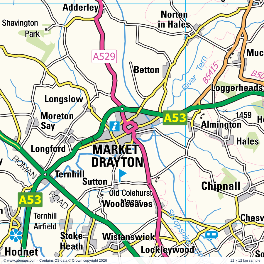
Market Drayton regional road map. Full 60 × 60 km PDF, SVG and Illustrator files, with a free PDF sample.

GBMAPS.COM

Market Drayton Regional Road Map

Call Us Now for Help01751 473136

GREAT BRITAIN ROAD ATLAS · 1:250,000 GB-360-0330

Market Drayton & surrounding area

Explore the full 60 × 60 km Market Drayton regional road map at 1:250,000, covering Wrexham, Wem, Whitchurch, Ellesmere, Madeley. Compare the complete coverage below; a detailed PDF sample is available free.

MARKET DRAYTON & SURROUNDING AREAREGIONAL ROAD MAP
60 × 60 km · Full map previewDownload the free SVG ↓

INSIDE THE FULL 60 × 60 KM MAP

Explore the Market Drayton map area

1:250,000 cartography

Towns, villages & places

More mapped places (378)
  • Booley
  • Prees
  • Peplow
  • Longford
  • Ollerton
  • Sutton
  • Aston
  • Wistanswick
  • Besford
  • Calverhall
  • Longslow
  • Edstaston
  • Edgebolton
  • Ightfield
  • Woodseaves
  • High Heath
  • Mill Green
  • Muckleton
  • Whixall
  • Shawbury
  • Paddolgreen
  • Tilstock
  • Hollinwood
  • Hinstock
  • Rowton
  • Clive
  • Ash Magna
  • Grinshill
  • Welsh End
  • Waters Upton
  • Almington
  • Howle
  • Yorton
  • Wilkesley
  • Alkington
  • Betton
  • Adderley
  • Sleap
  • Walton
  • Broughall
  • Hales
  • Cheswardine
  • Cherrington
  • Alderton
  • Noneley
  • Newtown
  • Burleydam
  • Crudgington
  • Sambrook
  • Ellerton
  • Chipnall
  • Poynton
  • Wolverley
  • Hadnall
  • Soudley
  • Loppington
  • Tibberton
  • Coxbank
  • Astley
  • Harmer Hill
  • Roden
  • Northwood
  • Kinsey Heath
  • Myddle
  • Mucklestone
  • Pickstock
  • Sleapford
  • Bronington
  • Burlton
  • Audlem
  • Newhall
  • Haughton
  • Loggerheads
  • Kynnersley
  • Wirswall
  • Bettisfield
  • Knighton
  • Adeney
  • Puleston
  • Albrighton
  • Rodington
  • Lyneal
  • Merrington
  • Buerton
  • Marbury
  • Edgmond
  • Cockshutt
  • Knighton
  • Shebdon
  • Petton
  • Adbaston
  • Fairoak
  • Aston
  • Colemere
  • Hankelow
  • Outlands
  • Dorrington
  • Longford
  • Welshampton
  • Ashley
  • Hanmer
  • Uffington
  • Norbury
  • Wetwood
  • Walcot
  • Leaton
  • Forton
  • Sound
  • Sutton
  • Woore
  • Blackbrook
  • Croxton
  • Walford
  • Aston
  • Podmore
  • Baschurch
  • Fitz
  • Lilleshall
  • Norbury
  • Lee
  • Yeaton
  • Bagley
  • Hatherton
  • Sugnall
  • Bickley
  • Grafton
  • Onneley
  • Aston
  • Woodseaves
  • Chatcull
  • Uppington
  • Penley
  • Norton
  • Malpas
  • Ravensmoor
  • Checkley
  • Maer
  • Stapeley
  • Tetchill
  • Walgherton
  • Chorley
  • Pershall
  • Bicton
  • Atcham
  • Wykey
  • Rushton
  • Wroxeter
  • Standon
  • Hordley
  • Forton
  • Woodcote
  • Wybunbury
  • Lilyhurst
  • Threapwood
  • Blakenhall
  • Donnington
  • Moreton
  • Slindon
  • Haughton
  • Wrinehill
  • Faddiley
  • Ensdon
  • Acton
  • Brindley
  • Cranberry
  • Sturbridge
  • Montford
  • Burland
  • Rednal
  • Eardiston
  • Whitmore
  • Hough
  • Knolton
  • Mill Meece
  • Chorlton
  • Perthy
  • Willaston
  • Lawnhead
  • Berrington
  • Shavington
  • Dudleston Heath
  • Worthenbury
  • Grimpo
  • Dryton
  • Betley
  • Nesscliffe
  • Bayston Hill
  • Ellenhall
  • Duckington
  • Bickerton
  • Leighton
  • Gnosall
  • Ford
  • Crackleybank
  • Shrawardine
  • Wilcott
  • Cotes
  • Shocklach
  • Shoot Hill
  • Kinton
  • Cound
  • Tilston
  • Orslow
  • Bulkeley
  • Overton
  • Weirbrook
  • Buildwas
  • Leycett
  • Keele
  • Cantlop
  • Swynnerton
  • Weston
  • Cruckton
  • Balterley
  • Chebsey
  • Hanwood
  • Haughton
  • Sheinton
  • Condover
  • Ranton
  • Pentre
  • Brineton
  • Shifnal
  • Beech
  • Cruckmeole
  • High Onn
  • Barbridge
  • Babbinswood
  • Yarnfield
  • Worleston
  • Hindford
  • Dovaston
  • Knowl Wall
  • Broxton
  • Cardeston
  • Harthill
  • Wardle
  • Annscroft
  • Nox
  • Edgerley
  • Erbistock
  • Hanchurch
  • Spurstow
  • Pitchford
  • Blymhill
  • Peckforton
  • Stretton
  • Whittington
  • Whitecross
  • Barthomley
  • Kinnerley
  • Knockin
  • Burwardsley
  • Acton Pigott
  • Street Dinas
  • Clutton
  • Bunbury
  • Haughton
  • Yockleton
  • Middleton
  • Isycoed
  • Wyke
  • Longden
  • Lea
  • Woolston
  • Homer
  • St Martins
  • Kemberton
  • Marston
  • Tittensor
  • Stapleton
  • Harley
  • Barton
  • Great Ryton
  • Audley
  • Benthall
  • Alberbury
  • Calveley
  • Little Ryton
  • Plealey
  • Hinton
  • Eyton
  • Chowley
  • Brockton
  • Edge
  • Haslington
  • Beeston
  • Ridleywood
  • Alpraham
  • Maesbury
  • Ball
  • Dorrington
  • Crosslanes
  • Melverley
  • Kenley
  • Rowton
  • Stretton Heath
  • Gobowen
  • Frodesley
  • Tong
  • Derrington
  • Marchwiel
  • Pontesford
  • Bradley
  • Barrow
  • Holt
  • Ruckley
  • Barlaston
  • Tattenhall
  • Farley
  • Grindle
  • Oaks
  • Crewgreen
  • Farndon
  • Winterley
  • Gyfelia
  • Newton
  • Pontesbury
  • Longnor
  • Halton
  • Ryton
  • Llan-y-pwll
  • Westbury
  • Shackerley
  • Mitton
  • Churton
  • Asterley
  • Norton
  • Hassall
  • Wollaston
  • Talke
  • Lapley
  • Ruabon
  • Pulverbatch
  • Wheelock
  • Beckbury
  • Levedale
  • Westley
  • Habberley
  • Vennington
  • Whiston
  • Criggion
  • Albrighton
  • Minsterley
  • Stretton
  • Rhostyllen
  • Aldford
  • Middletown
  • Bersham
  • Boningale
  • Gresford
  • Ploxgreen
  • Brewood
  • Wagbeach
  • Rossett
  • Snailbeach
  • Newchapel
  • Bradley
  • Pulford
  • Gwersyllt
  • Harriseahead
  • Burton
  • Llay
  • Worthen
  • Codsall
  • Brynteg
  • Oaken
  • Rowley
  • Leigh
  • Brockton
  • Hope
  • Bilbrook
  • Binweston
  • Gravels
  • Caergwrle
  • Hope
  • Meadowtown
  • Rorrington

Roads across this sheet

M6, M54, A5, A34, A41, A49, A50, A51, A52, A53, A442, A458, A464, A488, A495, A500, A518, A519, A525, A527, A528, A529, A530, A531

More road numbers

A532, A533, A534, A539, A541, A550, A4169, A4640, A5006, A5007, A5008, A5009, A5010, A5011, A5013, A5015, A5016, A5019, A5020, A5035, A5064, A5078, A5112, A5124, A5152, A5156, A5182, A5191, A5223, A5271, A5272, B4176, B4373, B4375, B4376, B4379, B4380, B4386, B4387, B4393, B4394, B4396, B4397, B4398, B4473, B4499, B4579, B4580, B5009, B5012, B5026, B5027, B5038, B5041, B5044, B5045, B5047, B5050, B5051, B5061, B5062, B5063, B5065, B5067, B5068, B5069, B5070, B5071, B5074, B5076, B5077, B5078, B5079, B5097, B5098, B5099, B5100, B5101, B5102, B5130, B5314, B5315, B5334, B5338, B5341, B5352, B5367, B5368, B5369, B5370, B5371, B5373, B5395, B5398, B5405, B5415, B5425, B5426, B5430, B5433, B5445, B5446, B5476, B5490, B5500, B5605

Rivers & waterways

Caldon Canal, Cound Brook, Ellesmere Canal, Head of Trent, Llangollen Canal, Macclesfield Canal, Montgomery Canal, River Alyn / Afon Alun, River Ceiriog, River Dee / Afon Dyfrdwy, River Penk, River Perry

More waterways

River Roden, River Severn, River Sow, River Tern, River Trent, River Vyrnwy / Afon Efyrnwy, River Weaver, River Wheelock, River Worfe, Shropshire Union Canal, Shropshire Union Canal (Middlewich Branch), Staffordshire & Worcestershire Canal, Trent & Mersey Canal, Trent and Mersey Canal

Landmarks & landscape

Abbey, Acton Burnell Castle, Alyn Waters Country Park, Alyn Waters Country Park Visitor Centre, Apedale Community Country Park, Apedale Heritage Centre, Aqualate Hall, Attingham, Attingham Park, Aviation Museum, Bangor-on-Dee Racecourse, Battlefield 1403 Exhibition Centre

More named features

Beeston Castle, Benthall Hall, Bersham Heritage Centre, Bersham Ironworks, Biddulph Grange Garden, Blists Hill Victorian Town, Bonc Y Hafod Country Park, Boscobel House, Bridgemere Garden World, Broseley Pipe Works, Museum of the Gorge, Police Museum, Buildwas Abbey, Bunbury Watermill, Cane Workshop, Cantlop Bridge, Castle (remains of), Ceramica The Pottery Showcase, Chatterley Whitfield Heritage Country Park, Cheshire Candle Workshops, Cheshire Farm Ice Cream, Chillington Hall, Cholmondeley Castle, Cholmondeley Castle Gardens, Coalbrookdale Museum of Iron, Enginuity, Coalport China Museum, Jackfield Tile Museum, Colemere Country Park, Craft Centre, Dagfields Craft & Antiques Centre, Darby Houses, David Austin Roses Ltd, Dorfold Hall, Dorfold Hall Gardens, Eastridge Wood Cycle Trail, Englesea-brook Heritage Centre, Erbistock Gardens, Erddig, Erddig Country Park, Etruria Industrial Museum, The Potteries Museum, The Dudson Centre, Eyton on Severn Point to Point Racecourse, Ford Green Hall Museum, Gentleshaw Wildlife Centre, Granville Country Park, Greenway Bank Country Park & Visitor Centre, Hack Green Secret Nuclear Bunker, Haughmond Abbey, Hawkstone Park and Visitor Centre, Hayford Solar Farm, Hodnet Gardens, Home Farm Attingham, Hoo Farm, Ironbridge Gorge (World Heritage Site), Ironbridge Gorge Tourist Visitor Centre, Isaak Waltons Cottage & Museum, Lakemoor Park Farm, Langley Chapel, Lilleshall Abbey, Little Moreton Hall, Lyth Hill Country Park, Mill Meece Pumping Station, Moat House, Moorcroft, Moorland Pottery, Moreton Corbet Castle, Nantwich Museum, Nature Reserve, Nesscliffe Hill Country Park, Old Colehurst Manor, Old Man of Mow, Oriel Wrecsam, Park Hall Countryside Experience, Patshull Hall, Pendeford Mill Nature Reserve, Poles Coppice Nature Reserve, Prees Branch Canal Nature Reserve, RAF Museum Cosford, Reaseheath College, Remains of Bedlam Furnaces, Rode Hall, Rode Hall Garden, Rowley's House Museum, Coleham Pumping Station, Shropshire Regimental Museum, Shrewsbury Museum & Art Gallery, Rowton Castle, Ruewood Meadow Nature Reserve, Shavington Park, Shelton Pottery, Shrewsbury Abbey, Shrewsbury Castle, Shropshire Wildlife Centre, Major Art Galleries, Silverdale Country Park, Snailbeach Mine, Snugbury's Famous Jersey Ice Cream, Solar Farm, Sontley Moor Nature Reserve, St Milburga's Priory, Stretton Watermill, Sunnycroft, Telford Steam Trust, The Borough Museum and Art Gallery, The Dorothy Clive Memorial Garden, The Mere, Visitor Centre, The Plassey Craft Centre, The Railway Age, The Trentham Estate, The Wedgewood Story, Trentham Monkey Forest, Visitor Centre, Wallerton Old Hall Garden, Wedgewood Museum, Wenlock Pottery, Westo Wood Fisheries, Weston Park, Weston Park & Deer Park, Whitchurch Heritage Centre, White Ladies Priory, Whitmore Hall, Whittington Castle, Wrexham County Borough Museum, Wrockwardine Solar Farm, Wroxeter Roman City, Wroxeter Roman City and Museum, Wroxeter Roman Vineyard
Local authority & parish coverage

Wholly or partly within the full map rectangle. These boundaries are coverage information, not additional artwork layers.

  • Cheshire EastPartly within
  • Cheshire West and ChesterPartly within
  • City of Stoke-on-TrentPartly within
  • City of Wolverhampton DistrictPartly within
  • Newcastle-under-Lyme DistrictWholly within
  • Powys - PowysPartly within
  • ShropshirePartly within
  • Sir y Fflint - FlintshirePartly within
  • South Staffordshire DistrictPartly within
  • Stafford DistrictPartly within
  • Staffordshire Moorlands DistrictPartly within
  • Telford and WrekinWholly within
  • Wrecsam - WrexhamPartly within
Wards & electoral divisions 240 areas
  • Admaston & Bratton Ward
  • Alsager Ward
  • Apley Castle Ward
  • Arleston & College Ward
  • Audlem Ward
  • Audley Ward
  • Baddeley, Milton & Norton Ward (part)
  • Barlaston Ward (part)
  • Basford & Hartshill Ward
  • Bentilee, Ubberley & Townsend Ward (part)
  • Biddulph East Ward
  • Biddulph Moor Ward (part)
  • Biddulph North Ward (part)
  • Biddulph South Ward (part)
  • Biddulph West Ward
  • Bilbrook Ward (part)
  • Birches Head & Northwood Ward (part)
  • Blurton Ward (part)
  • Boothen Ward
  • Bradeley & Chell Heath Ward
  • Bradwell Ward
  • Brereton Rural Ward (part)
  • Brewood, Coven & Blymhill Ward (part)
  • Brookside Ward
  • Brown Edge and Endon Ward (part)
  • Bucknall & Eaton Park Ward (part)
  • Bunbury Ward (part)
  • Burslem Park Ward
  • Burslem Ward
  • Christleton & Huntington Ward (part)
  • Church Aston & Lilleshall Ward
  • Clayton Ward
  • Codsall Ward
  • Congleton East Ward (part)
  • Crackley & Red Street Ward
  • Crewe Central Ward
  • Crewe East Ward
  • Crewe North Ward
  • Crewe South Ward
  • Crewe St. Barnabas Ward
  • Crewe West Ward
  • Cross Heath Ward
  • Dawley & Aqueduct Ward
  • Donnington Ward
  • Doxey & Castletown Ward (part)
  • Eccleshall Ward
  • Edgmond Ward
  • Ercall Magna Ward
  • Ercall Ward
  • Etruria & Hanley Ward
  • Farndon Ward (part)
  • Fenton East Ward (part)
  • Fenton West & Mount Pleasant Ward (part)
  • Ford Green & Smallthorne Ward
  • Gnosall & Woodseaves Ward
  • Goldenhill & Sandyford Ward
  • Great Chell & Packmoor Ward
  • Hadley & Leegomery Ward
  • Hanford, Newstead & Trentham Ward (part)
  • Hanley Park, Joiner's Square & Shelton Ward
  • Hartshill Park & Stoke Ward
  • Haslington Ward
  • Haygate & Park Ward
  • Holditch & Chesterton Ward
  • Hollybush Ward (part)
  • Holmcroft Ward (part)
  • Horsehay & Lightmoor Ward
  • Ironbridge Gorge Ward
  • Keele Ward
  • Ketley Ward
  • Kidsgrove & Ravenscliffe Ward
  • Knutton Ward
  • Lapley, Stretton & Wheaton Aston Ward (part)
  • Lawley Ward
  • Leighton Ward
  • Little Chell & Stanfield Ward
  • Loggerheads Ward
  • Madeley & Betley Ward
  • Madeley & Sutton Hill Ward
  • Maer & Whitmore Ward
  • Malinslee & Dawley Bank Ward
  • Malpas Ward
  • May Bank Ward
  • Milwich Ward (part)
  • Moorcroft & Sneyd Green Ward
  • Muxton Ward
  • Nantwich North and West Ward
  • Nantwich South and Stapeley Ward
  • Newchapel & Mow Cop Ward
  • Newport East Ward
  • Newport North Ward
  • Newport South Ward
  • Newport West Ward
  • Oakengates & Ketley Bank Ward
  • Odd Rode Ward (part)
  • Overdale & The Rock Ward
  • Oxley Ward (part)
  • Park Ward (part)
  • Pattingham, Trysull, Bobbington & Lower Penn Ward (part)
  • Penkhull & Springfields Ward
  • Penkridge North & Acton Trussell Ward (part)
  • Perton East Ward (part)
  • Perton Lakeside Ward (part)
  • Perton Wrottesley Ward (part)
  • Priorslee Ward
  • Rowley Ward (part)
  • Sandbach Ettiley Heath and Wheelock Ward (part)
  • Sandbach Heath and East Ward (part)
  • Seighford & Church Eaton Ward (part)
  • Shavington Ward
  • Shawbirch & Dothill Ward
  • Silverdale Ward
  • St. Georges Ward
  • St. Michael's & Stonefield Ward (part)
  • St. Peters Ward (part)
  • Swynnerton & Oulton Ward (part)
  • Talke & Butt Lane Ward
  • Tattenhall Ward (part)
  • Tettenhall Regis Ward (part)
  • Tettenhall Wightwick Ward (part)
  • The Nedge Ward
  • Thistleberry Ward
  • Town Ward
  • Trent Vale & Oak Hill Ward
  • Tunstall Ward
  • Walton Ward (part)
  • Westbury Park & Northwood Ward
  • Westlands Ward
  • Willaston and Rope Ward
  • Wistaston Ward
  • Wolstanton Ward
  • Woodside Ward
  • Wrenbury Ward
  • Wrockwardine Ward
  • Wrockwardine Wood & Trench Ward
  • Wybunbury Ward
  • Abbey ED
  • Acton and Maesydre ED
  • Albrighton ED
  • Bagley ED
  • Bangor Is-y-Coed ED
  • Battlefield ED
  • Bayston Hill ED
  • Belle Vue ED
  • Bicton Heath ED
  • Bishop's Castle ED (part)
  • Borras Park ED
  • Bronington and Hanmer ED
  • Broseley ED
  • Brymbo ED (part)
  • Bryn Cefn ED (part)
  • Brynyffynnon ED
  • Burnell ED (part)
  • Caergwrle ED (part)
  • Cartrefle ED
  • Castlefields & Ditherington ED
  • Cheswardine ED
  • Chirbury & Worthen ED (part)
  • Chirk North ED (part)
  • Chirk South ED (part)
  • Claverley & Worfield ED (part)
  • Coedpoeth ED (part)
  • Column & Sutton ED
  • Copthorne ED
  • Ellesmere Urban ED
  • Erddig ED
  • Esclusham ED
  • Garden Village ED
  • Gresford East and West ED
  • Grosvenor ED
  • Gwenfro ED (part)
  • Gwersyllt East ED
  • Gwersyllt North ED
  • Gwersyllt South ED
  • Gwersyllt West ED
  • Harlescott ED
  • Hermitage ED
  • Higher Kinnerton ED (part)
  • Hodnet ED
  • Holt ED
  • Hope ED (part)
  • Little Acton ED
  • Llandrinio ED (part)
  • Llandysilio ED (part)
  • Llanfynydd ED (part)
  • Llanymynech ED (part)
  • Llay ED
  • Longden ED
  • Loton ED
  • Marchwiel ED
  • Marford and Hoseley ED
  • Market Drayton East & Rural ED
  • Market Drayton North ED
  • Market Drayton South ED
  • Meole ED
  • Monkmoor ED
  • Much Wenlock ED (part)
  • New Broughton ED
  • Offa ED
  • Oswestry North ED (part)
  • Oswestry North East ED (part)
  • Oswestry South East ED (part)
  • Oteley & Reabrook ED
  • Overton and Maelor South ED
  • Pant and Johnstown ED (part)
  • Pen-y-ffordd ED (part)
  • Penycae and Ruabon South ED (part)
  • Ponciau ED (part)
  • Porthill ED
  • Prees ED
  • Quarry & Coton Hill ED
  • Queensway ED
  • Radbrook ED
  • Rea Valley ED
  • Rhosnesni ED
  • Rossett ED (part)
  • Ruabon ED (part)
  • Ruyton & Baschurch ED
  • Selattyn & Gobowen ED (part)
  • Severn Valley ED (part)
  • Shawbury ED
  • Shifnal North ED
  • Shifnal Rural ED (part)
  • Shifnal South ED
  • Smithfield ED
  • St. Martin's ED (part)
  • St. Oswald ED (part)
  • Stansty ED
  • Sundorne & Old Heath ED
  • Tern ED
  • The Meres ED
  • Trelystan and Trewern ED (part)
  • Underdale ED
  • Wem ED
  • Whitchurch North ED
  • Whitchurch South ED
  • Whitchurch West ED
  • Whitegate ED
  • Whittington ED (part)
  • Wynnstay ED
Civil parishes & communities 305 areas
  • Abenbury Community
  • Acton Burnell CP
  • Acton Community
  • Adbaston CP
  • Adderley CP
  • Agden CP
  • Alberbury with Cardeston CP
  • Albrighton and Donington CP
  • Aldersey CP
  • Aldford and Saighton CP (part)
  • Alpraham and Calveley CP (part)
  • Alsager CP
  • Astley CP
  • Aston Juxta Mondrum CP
  • Atcham CP
  • Audlem CP
  • Audley Rural CP
  • Austerson CP
  • Baddiley CP
  • Baddington CP
  • Badger CP (part)
  • Balterley CP
  • Bangor is-y-Coed Community
  • Barlaston CP (part)
  • Barrow CP (part)
  • Barthomley CP
  • Barton CP
  • Baschurch CP
  • Bausley with Criggion Community (part)
  • Bayston Hill CP
  • Beckbury CP
  • Beeston CP (part)
  • Berrington CP
  • Betchton CP (part)
  • Betley CP
  • Bickerton CP
  • Bicton CP
  • Biddulph CP (part)
  • Bilbrook CP (part)
  • Blymhill and Weston-under-Lizard CP
  • Bomere Heath and District CP
  • Boningale CP
  • Bradley CP (part)
  • Brewood and Coven CP (part)
  • Brindley CP
  • Bronington Community
  • Broomhall CP
  • Broseley CP
  • Broughton Community (part)
  • Brown Edge CP (part)
  • Broxton CP
  • Brymbo Community (part)
  • Buerton CP
  • Buildwas CP
  • Bulkeley and Ridley CP
  • Bunbury CP
  • Burland and Acton CP
  • Burwardsley CP
  • Caia Park Community
  • Carden CP
  • Chapel and Hill Chorlton CP
  • Chebsey CP
  • Cheswardine CP
  • Chetwynd Aston and Woodcote CP
  • Chetwynd CP
  • Chidlow CP
  • Child's Ercall CP
  • Chirbury with Brompton CP (part)
  • Chirk Community (part)
  • Cholmondeley CP
  • Cholmondeston CP (part)
  • Chorley CP
  • Chorlton CP
  • Chowley CP
  • Church Aston CP
  • Church Eaton CP
  • Church Lawton CP
  • Church Minshull CP (part)
  • Church Pulverbatch CP (part)
  • Churton CP
  • Clive CP
  • Clutton CP
  • Cockshutt CP
  • Coddington CP
  • Codsall CP
  • Coedpoeth Community (part)
  • Condover CP
  • Congleton CP (part)
  • Coole Pilate CP
  • Coppenhall CP (part)
  • Cound CP (part)
  • Cressage CP
  • Creswell CP (part)
  • Crewe CP
  • Cuddington CP
  • Dawley Hamlets CP
  • Dodcott cum Wilkesley CP
  • Doddington and District CP
  • Dodleston CP (part)
  • Donnington and Muxton CP
  • Doxey CP (part)
  • Duckington CP
  • Dunston CP (part)
  • Eaton and Eccleston CP (part)
  • Eccleshall CP
  • Edgmond CP
  • Egerton CP
  • Ellenhall CP
  • Ellesmere Rural CP
  • Ellesmere Urban CP
  • Erbistock Community
  • Ercall Magna CP
  • Esclusham Community (part)
  • Eyton upon the Weald Moors CP
  • Faddiley CP
  • Farndon CP
  • Ford CP
  • Forton CP
  • Frodesley CP (part)
  • Gnosall CP
  • Golborne David CP (part)
  • Great Dawley CP
  • Great Hanwood CP
  • Great Ness CP
  • Gresford Community
  • Grinshill CP
  • Gwersyllt Community
  • Hadley and Leegomery CP
  • Hadnall CP
  • Handley CP
  • Hankelow CP
  • Hanmer Community
  • Harley CP (part)
  • Harthill CP
  • Haslington CP
  • Hassall CP
  • Hatherton CP
  • Haughton CP
  • Haughton CP
  • High Offley CP
  • Higher Kinnerton Community (part)
  • Hinstock CP
  • Hodnet CP
  • Hollinswood and Randlay CP
  • Holt Community
  • Hope Community (part)
  • Hordley CP
  • Hough and Chorlton CP
  • Hyde Lea CP (part)
  • Ightfield CP
  • Isycoed Community
  • Keele CP
  • Kemberton CP
  • Kenley CP (part)
  • Ketley CP
  • Kidsgrove CP
  • Kinnerley CP (part)
  • Knockin CP
  • Kynnersley CP
  • Lapley, Stretton and Wheaton Aston CP (part)
  • Lawley and Overdale CP
  • Leebotwood CP (part)
  • Leighton CP
  • Leighton and Eaton Constantine CP
  • Lilleshall CP
  • Little Ness CP
  • Little Wenlock CP
  • Llandrinio Community (part)
  • Llandysilio Community (part)
  • Llanfynydd Community (part)
  • Llay Community
  • Loggerheads CP
  • Longden CP
  • Longnor CP (part)
  • Loppington CP
  • Madeley CP
  • Madeley CP
  • Maelor South Community
  • Maer CP
  • Malpas CP
  • Marbury and District CP
  • Marchwiel Community
  • Market Drayton CP
  • Melverley CP
  • Minshull Vernon CP (part)
  • Minsterley CP
  • Montford CP
  • Moreton Corbet and Lee Brockhurst CP
  • Moreton Say CP
  • Moreton cum Alcumlow CP (part)
  • Moston CP (part)
  • Much Wenlock CP (part)
  • Myddle, Broughton and Harmer Hill CP
  • Nantwich CP
  • Newbold Astbury CP (part)
  • Newhall CP
  • Newport CP
  • No Man's Heath and District CP
  • Norbury CP
  • Norton in Hales CP
  • Oakengates CP
  • Odd Rode CP
  • Offa Community
  • Oswestry CP (part)
  • Oswestry Rural CP (part)
  • Overton Community
  • Pattingham and Patshull CP (part)
  • Peckforton CP
  • Penkridge CP (part)
  • Penyffordd Community (part)
  • Perton CP (part)
  • Petton CP
  • Pitchford CP
  • Pontesbury CP
  • Poole CP
  • Poulton and Pulford CP (part)
  • Prees CP
  • Preston upon the Weald Moors CP
  • Ranton CP
  • Ratlinghope CP (part)
  • Rhosddu Community
  • Rhosllanerchrugog Community (part)
  • Rodington CP
  • Rope CP
  • Rossett Community (part)
  • Ruabon Community (part)
  • Ruckley and Langley CP (part)
  • Ruyton-XI-Towns CP
  • Ryton CP
  • Sandbach CP (part)
  • Seighford CP (part)
  • Selattyn and Gobowen CP (part)
  • Sesswick Community
  • Shavington cum Gresty CP
  • Shawbury CP
  • Sheinton CP
  • Sheriffhales CP
  • Shifnal CP
  • Shocklach Oviatt and District CP
  • Shrewsbury CP
  • Silverdale CP
  • Smallwood CP (part)
  • Smethcott CP (part)
  • Sound CP
  • Spurstow CP
  • St. Georges and Priorslee CP
  • St. Martin's CP (part)
  • Standon CP
  • Stanton upon Hine Heath CP
  • Stapeley and District CP
  • Stirchley and Brookside CP
  • Stockton CP (part)
  • Stoke and Hurleston CP
  • Stoke upon Tern CP
  • Stone CP (part)
  • Stone Rural CP (part)
  • Stretton CP
  • Sutton Maddock CP
  • Sutton upon Tern CP
  • Swynnerton CP
  • Tattenhall and District CP (part)
  • The Gorge CP
  • Threapwood CP
  • Tibberton and Cherrington CP
  • Tilston CP
  • Tiverton and Tilstone Fearnall CP (part)
  • Tong CP
  • Trewern Community (part)
  • Tushingham-cum-Grindley, Macefen and Bradley CP
  • Uffington CP
  • Upton Magna CP
  • Walgherton CP
  • Wardle CP
  • Warmingham CP (part)
  • Waters Upton CP
  • Wellington CP
  • Welshampton and Lyneal CP
  • Wem Rural CP
  • Wem Urban CP
  • West Felton CP
  • Westbury CP (part)
  • Weston and Crewe Green CP
  • Weston-under-Redcastle CP
  • Wettenhall CP (part)
  • Whitchurch Rural CP
  • Whitchurch Urban CP
  • Whitgreave CP (part)
  • Whitmore CP
  • Whittington CP (part)
  • Whixall CP
  • Wigland CP
  • Willaston CP
  • Willington Worthenbury Community
  • Wistaston CP
  • Withington CP
  • Woolstanwood CP
  • Woore CP
  • Worleston CP
  • Worthen with Shelve CP (part)
  • Wrenbury cum Frith CP
  • Wrockwardine CP
  • Wrockwardine Wood and Trench CP
  • Wroxeter and Uppington CP
  • Wybunbury CP
  • Yarnfield and Cold Meece CP

Source: the GBMaps road atlas, OS Boundary-Line and postcode mapping datasets. Source editions are being checked for publication. Unmarked boundary names are wholly within the sheet; “part” means the map edge crosses the area.

Place lists are selected from the map source, not a complete gazetteer. Named features describe the cartography; visitor facilities and opening status are not verified. The free sample covers only 12 × 12 km of this larger sheet.

INSIDE YOUR DOWNLOAD

A proper road map, in useful formats

Road classifications, towns and villages, railways, rivers, landscape detail and tourist symbols, brought together in the GBMaps regional road atlas style.

PDF filePDFSVG fileSVGAdobe Illustrator AI fileAi

PDF for the finished map. SVG and layered Illustrator artwork for adapting colours, adding your own information and preparing designs.

THE FINISHED SHEET

Designed for print and presentation

Map coverage
60 × 60 km
Sample coverage
12 × 12 km
Print layout
A3 landscape · enlarged 1:250k cartography
Sheet furniture
Border, scale bar, key & north arrow

A few useful details

What changes when I select another square?

Select a surrounding square to bring it into the centre and reveal the maps around it. Each square is a different 60 × 60 km map. The preview, free sample and selected download change together. Neighbouring sheets overlap by 30 km so you can choose the coverage that suits you.

Is the free sample a vector map?

The on-page detail is an SVG. The free download is a separate 12 × 12 km PDF with a link to the full map. Please retain its copyright credits and product link when sharing it.

Can I buy a larger combined map?

These downloads are individual ready-made sheets. Contact GBMaps if you need a larger combined area.

FREE PDF SAMPLE

Your free map sample

Your free 12 × 12 km sample includes a link back to this map, so you can return for the full area whenever you need it.

Download free PDF sample ↓

Get your Market Drayton map

Map download bundle

£24.00including VATOne payment

Pay securely

One payment. Your map stays open.

Your map download

Your map files

Preparing your download…

Checking your private download link…

Your map downloads

Already bought a map?

Find the downloads from your purchases.

Enter the email address you used at checkout. We’ll email you a private link to your available map downloads.