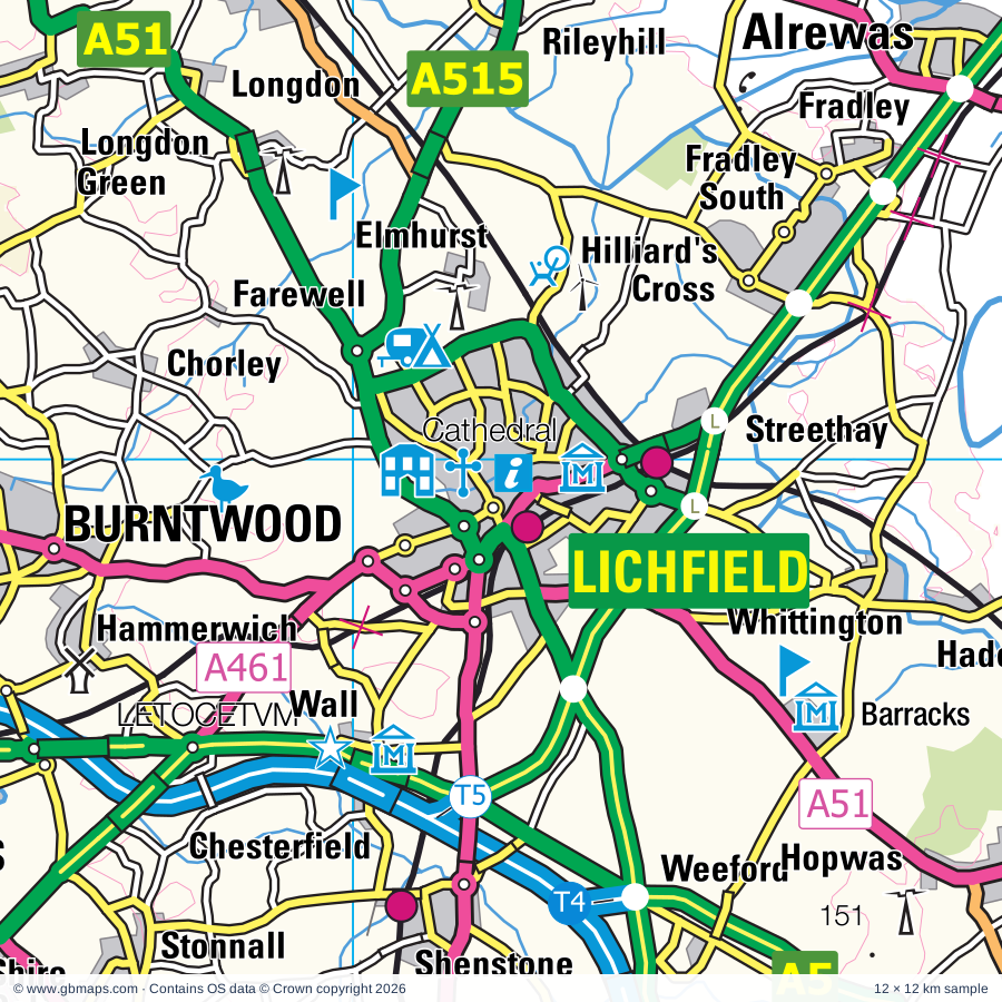
Lichfield regional road map. Full 60 × 60 km PDF, SVG and Illustrator files, with a free PDF sample.

GBMAPS.COM

Lichfield Regional Road Map

Call Us Now for Help01751 473136

GREAT BRITAIN ROAD ATLAS · 1:250,000 GB-420-0300

Lichfield & surrounding area

Explore the full 60 × 60 km Lichfield regional road map at 1:250,000, covering Lichfield, Fazeley, Tamworth, Atherstone, Coleshill. Compare the complete coverage below; a detailed PDF sample is available free.

LICHFIELD & SURROUNDING AREAREGIONAL ROAD MAP
60 × 60 km · Full map previewDownload the free SVG ↓

INSIDE THE FULL 60 × 60 KM MAP

Explore the Lichfield map area

1:250,000 cartography

Towns, villages & places

More mapped places (279)

Roads across this sheet

M1, M5, M6, M40, M42, M45, M54, M69, A5, A6, A34, A38, A38(M), A41, A45, A47, A50, A51, A58, A423, A426, A428, A429, A435

More road numbers

A441, A444, A446, A447, A448, A449, A451, A452, A453, A454, A455, A456, A457, A458, A459, A460, A461, A462, A463, A491, A511, A512, A513, A514, A515, A518, A3400, A4026, A4029, A4030, A4031, A4033, A4034, A4036, A4037, A4038, A4039, A4040, A4041, A4053, A4061, A4071, A4082, A4091, A4092, A4097, A4098, A4099, A4100, A4101, A4102, A4114, A4123, A4124, A4126, A4141, A4148, A4150, A4167, A4168, A4177, A4182, A4196, A4252, A4254, A4400, A4510, A4540, A4600, A4601, A5013, A5121, A5127, A5132, A5148, A5189, A5190, A5192, A5195, A5206, A6006, B384, B425, B460, B578, B581, B582, B585, B586, B587, B590, B591, B4025, B4029, B4043, B4065, B4076, B4082, B4091, B4096, B4098, B4100, B4101, B4102, B4103, B4104, B4106, B4107, B4109, B4110, B4111, B4112, B4113, B4114, B4115, B4116, B4117, B4118, B4119, B4120, B4121, B4122, B4124, B4125, B4126, B4127, B4128, B4129, B4132, B4133, B4135, B4136, B4137, B4138, B4139, B4140, B4142, B4144, B4145, B4146, B4147, B4148, B4149, B4151, B4152, B4153, B4154, B4155, B4156, B4161, B4162, B4163, B4166, B4167, B4169, B4170, B4171, B4172, B4173, B4174, B4175, B4176, B4177, B4179, B4180, B4182, B4183, B4184, B4185, B4186, B4187, B4188, B4200, B4210, B4217, B4284, B4428, B4429, B4438, B4439, B4453, B4455, B4464, B4483, B4484, B4514, B4515, B4516, B4517, B4531, B4532, B4544, B4551, B4563, B4583, B4587, B4588, B4590, B4642, B4666, B4667, B4668, B4669, B5000, B5006, B5008, B5010, B5011, B5012, B5013, B5014, B5016, B5017, B5018, B5066, B5080, B5234, B5324, B5353, B5404, B5416, B5440, B5493, B6540
Rivers & waterways

Ashby-de-la-Zouch Canal, Balls Hill Branch Canal, Birmingham & Fazeley Canal, Birmingham Canal (Birmingham Level), Birmingham Canal (Wolverhampton Level), Bradley Locks, Canal, Canal (disused), Cannock Extension Canal, Coventry Canal, Digbeth Branch Canal, Dudley Canal

More waterways

Dudley Canal (Netherton Tunnel Branch), Gower Branch Canal, Grand Union Canal, Grand Union Canal (Birmingham & Warwick Junction section), Lapworth Link Canal, Oxford Canal, Pensnett Canal, Ratcliffe Cut, River Anker, River Avon, River Blithe, River Blythe, River Cole, River Dove, River Mease, River Penk, River Sence, River Soar, River Sow, River Sowe, River Stour, River Tame, River Trent, Rushall Canal, Shropshire Union Canal, Staffordshire & Hatherton Branch Canal (disused), Staffordshire & Worcester Canal, Staffordshire & Worcestershire Canal, Staffordshire and Worcester Canal, Staffordshire and Worcestershire Canal, Stourbridge Canal, Stratford-upon-Avon Canal, Tame Valley Canal, Titford Canal, Titford Feeder, Trent & Mersey Canal, Walsall Canal, Walsall Canal (Anson Branch), Wide Waters, Worcester & Birmingham Canal, Wyley & Essington Canal (disused), Wyrley & Essington Canal, Wyrley & Essington Canal (disused)

Landmarks & landscape

Abbey, Aeropark, Amerton Farm & Railway, Ancient High House and Staffordshire Yeomanry Museum, Arbury, Ash End House Children's Farm, Ashby Museum, Ashby-De-La-Zouch Castle, Ashby-de-la-Zouch Castle, Aston Hall, Aston Manor Transport Museum, Baddesley Clinton

More named features

Bagworth Heath Woods, Berkswell Village Museum, Berkswell Windmill, Bilston Museum & Art Gallery, Birches Valley Forest Centre, Go Ape Cannock, Birmingham Museum & Art Gallery, The Museum of the Jewellery Quarter, Thinktank,Birmingham Science Museum, Birmingham Sports Centre, Balsall Heath City Farm, Birmingham and Midland Museum of Transport, Black Country Museum, Bluebell Arboretum, Bosworth Battlefield Country Park, Botanical Gardens, Boxtrees Farm Craft Centre, Brandon Marsh Nature Reserve, Branston Water Park, Brewhouse Arts Centre, Brockswood Animal Sanctuary, Bumble Hole & Warrens Hall Visitor Centre, Burbage Common and Woods Local Nature Reserve, Cadbury World, Calke Abbey, Cannock Chase Country Park, Cannock Chase Visitor Centre, Cannon Hill Country Park, Canon Hill Park, Canwell Hall, Castle Bromwich Hall Gardens, Castle Ring Fort, Chasewater Country Park, Chasewater Railway, Chilvers Coton Craft Centre, Christian Heritage Centre, Claymills Victorian Pumping Station, Clent Hills Country Park, Clowes Wood Nature Reserve, Conkers Waterside Centre, Conkers, Coombe Abbey, Coombe Valley Country Park, Coventry Cathedral, Craft Centre, Cross, Curborough Antiques & Craft Centre, Donington Park, Donnington Grand Prix Collection, Doxey Marshes Nature Reserve, Drayton Manor Family Theme Park, Dudley Castle, Dudley Zoo, Erasmus Darwin House, Ferrers Centre for Arts and Crafts, Forge Mill Farm, Gailey Pottery, Galton Valley Canal Heritage Centre, Haden Hill House, Hagley Hall, Halesowen Abbey, Hartshill Hayes Country Park, Hartshill Hayes Country Park Woodland Nature Reserve, Hayhead Wood Nature Reserve, Heart of England Adventure Park Activity Centre, Hednesford Hills Common Nature Reserve, Hinkley and District Museum, Holdens Brewery, Kegworth Museum, Kenilworth Castle, Kingfisher Country Park, Kingsbury Water Park, Letocetum Roman Town, Lichfield Cathedral, Lickey Hills Country Park, Visitor Centre, Mallory Park Motor Racing Circuit, Manor House, Market Bosworth Country Park, Measham Museum, Melbourne Hall and Gardens, Meriden Cross, Middleton Hall, Midland Air Museum, Millennium Point, Moira Furnace, Moseley Old Hall, Museum of British Road Transport, Museum of Cannock Chase, National Memorial Aboretum, Visitor Centre, Armed Forces Memorial, National Motorcycle Museum, National Sea Life Centre, Nature Reserve, Northycote Farm and Country Park, Nuneaton Museum and Art Gallery, Oak House Museum, Packwood House, Parkridge Centre, Pipe Hall Nature Reserve, Pooley Country Park, Pooley Fields Heritage Centre, Priory Gardens Visitor Centre, Rosliston Forestry Centre, Rough Wood Country Park, Royal Brierley Experience, Ryton Organic Gardens, Ryton Pools, Ryton Pools Country Park Visitor Centre, Samuel Johnson's Birthplace, Teddy Bear Museum, Sandwell Valley Country Park, Selly Manor Museum, Sence Valley Forest Park, Shackerstone Railway Museum, Sharpe's Pottery Museum, Sheldon Country Park, Shire Country Park, Shugborough Farm Museum, Shugborough Hall, Shugborough Hall, Shugborough Estate NT, Snibston Discovery Park, Soho House Museum, St Chad's Cathedral, St Philip's Cathedral, Stafford Castle, Staunton Harold Church, Staunton Harold Hall, Staunton Harold Reservoir Visitor Centre, Stoneleigh Abbey, Stoneleigh Park Showground, Stoneywell, Sutton Park Visitor Centre, Tamworth Castle & Museum, The Barber Institute of Fine Arts, The Battlefield Line, The Leasowes Visitor Centre, The Lunt (Restored Roman Fort), The Lunt Roman Fort, The Staffordshire Regiment Museum, Tropical Bird Land, Twycross Zoo, Umberslade Farm Park, Visitor Centre, Wall Roman Site (Letocetum) Museum, Walsall Aboretum, Walsall Museum and Art Gallery, Walsall Leather Centre Museum, Waseley Hills Country Park, Visitor Centre, Wednesbury Museum and Art Gallery, Weoley Castle, West Midlands Police Museum, Willenhall Museum, Wolverhampton Museum and Art Gallery, Woodgate Valley Country Park, Woodgate Valley Visitor Centre, Woodgate Valley Urban Farm, Wyken Croft Nature Park

Local authority & parish coverage

Wholly or partly within the full map rectangle. These boundaries are coverage information, not additional artwork layers.

  • Birmingham DistrictWholly within
  • Blaby DistrictPartly within
  • Bromsgrove DistrictPartly within
  • Cannock Chase DistrictWholly within
  • Charnwood DistrictPartly within
  • City of DerbyPartly within
  • City of Wolverhampton DistrictPartly within
  • Coventry DistrictWholly within
  • Dudley DistrictPartly within
  • East Staffordshire DistrictPartly within
  • Harborough DistrictPartly within
  • Hinckley and Bosworth DistrictPartly within
  • Lichfield DistrictWholly within
  • North Warwickshire DistrictWholly within
  • North West Leicestershire DistrictPartly within
  • Nuneaton and Bedworth DistrictWholly within
  • Rugby DistrictPartly within
  • Rushcliffe DistrictPartly within
  • Sandwell DistrictWholly within
  • Solihull DistrictWholly within
  • South Derbyshire DistrictPartly within
  • South Staffordshire DistrictPartly within
  • Stafford DistrictPartly within
  • Stratford-on-Avon DistrictPartly within
  • Tamworth DistrictWholly within
  • Walsall DistrictWholly within
  • Warwick DistrictPartly within
  • Wychavon DistrictPartly within
  • Wyre Forest DistrictPartly within
Wards & electoral divisions 444 areas
  • Acocks Green Ward
  • Admirals and Cawston Ward
  • Aldridge Central & South Ward
  • Aldridge North & Walsall Wood Ward
  • Allens Cross Ward
  • Alrewas & Fradley Ward
  • Alum Rock Ward
  • Alvechurch South Ward (part)
  • Alvechurch Village Ward
  • Ambien Ward
  • Amblecote Ward (part)
  • Amington Ward
  • Anglesey Ward
  • Appleby Ward
  • Arbury Ward
  • Arley and Whitacre Ward
  • Armitage with Handsacre Ward
  • Ashby Castle Ward
  • Ashby Holywell Ward
  • Ashby Ivanhoe Ward
  • Ashby Money Hill Ward
  • Ashby Willesley Ward
  • Ashby Woulds Ward
  • Aston Fields Ward (part)
  • Aston Ward
  • Aston Ward (part)
  • Atherstone Central Ward
  • Atherstone North Ward
  • Atherstone South and Mancetter Ward
  • Attleborough Ward
  • Bablake Ward
  • Baddesley and Grendon Ward
  • Bagots & Needwood Ward
  • Balsall & Berkswell Ward
  • Balsall Heath West Ward
  • Bardon Ward
  • Barlestone, Nailstone and Osbaston Ward
  • Barnt Green & Hopwood Ward
  • Bartley Green Ward
  • Barwell Ward
  • Baswich Ward
  • Bearwood Ward
  • Bede Ward
  • Beechdale, Leamore & Reedswood Ward
  • Belbroughton & Romsley Ward
  • Belgrave Ward
  • Belle Vale Ward
  • Benn Ward (part)
  • Bentley & Darlaston North Ward
  • Bilbrook Ward (part)
  • Billesley Ward
  • Bilston North Ward
  • Bilston South Ward
  • Bilton Ward
  • Binley & Willenhall Ward
  • Birchfield Ward
  • Blackfordby Ward
  • Blackheath Ward
  • Blakenhall Ward
  • Bloxwich East & Blakenall Heath Ward
  • Bloxwich West Ward
  • Blythe Ward
  • Blythe Ward (part)
  • Bolehall Ward
  • Boley Park Ward
  • Boney Hay & Central Ward
  • Bordesley & Highgate Ward
  • Bordesley Green Ward
  • Bournbrook & Selly Park Ward
  • Bourne Vale Ward
  • Bournville & Cotteridge Ward
  • Brandwood & King's Heath Ward
  • Branston Ward
  • Brereton & Ravenhill Ward
  • Brewood, Coven & Blymhill Ward (part)
  • Brierley Hill & Wordsley South Ward (part)
  • Bristnall Ward
  • Brizlincote Ward
  • Brockmoor & Pensnett Ward (part)
  • Bromford & Hodge Hill Ward
  • Bromsgrove Central Ward (part)
  • Broom Leys Ward
  • Brownhills Ward
  • Bulkington Ward
  • Burbage Sketchley and Stretton Ward
  • Burbage St. Catherines and Lash Hill Ward
  • Burton & Eton Ward
  • Bushbury North Ward
  • Bushbury South & Low Hill Ward
  • Cadeby, Carlton and Market Bosworth with Shackerstone Ward
  • Camp Hill Ward
  • Cannock Longford & Bridgtown Ward
  • Cannock Park & Old Fallow Ward
  • Castle & Priory Ward
  • Castle Bromwich Ward
  • Castle Donington Castle Ward
  • Castle Donington Central Ward (part)
  • Castle Donington Park Ward
  • Castle Rock Ward (part)
  • Castle Vale Ward
  • Castle Ward
  • Catshill North Ward
  • Catshill South Ward
  • Chadsmead Ward
  • Chadsmoor Ward
  • Charford Ward (part)
  • Charlemont & Grove Vale Ward
  • Chase Terrace Ward
  • Chasetown Ward
  • Chellaston & Shelton Lock Ward (part)
  • Chelmsley Wood Ward
  • Cheslyn Hay Village Ward
  • Cheylesmore Ward
  • Chilvers Coton Ward
  • Church Gresley Ward
  • Coalville East Ward
  • Coalville West Ward
  • Cofton Ward
  • Coleshill North Ward
  • Coleshill South Ward
  • Colton & the Ridwares Ward
  • Common Ward
  • Coseley Ward
  • Coton Ward
  • Cradley Heath & Old Hill Ward
  • Cradley North & Wollescote Ward
  • Crown Ward (part)
  • Cubbington & Leek Wootton Ward (part)
  • Curborough Ward
  • Curdworth Ward
  • Daleacre Hill Ward (part)
  • Darlaston South Ward
  • Dishley, Hathern & Thorpe Acre Ward (part)
  • Dodderhill Ward (part)
  • Dordon Ward
  • Dorridge & Hockley Heath Ward
  • Dove Ward
  • Doxey & Castletown Ward (part)
  • Drakes Cross Ward
  • Druids Heath & Monyhull Ward
  • Dunsmore Ward (part)
  • Earl Shilton Ward
  • Earlsdon Ward
  • East Park Ward
  • Eastboro Ward
  • Eastlands Ward (part)
  • Edgbaston Ward
  • Ellistown & Battleflat Ward
  • Elmdon Ward
  • Erdington Ward
  • Essington Ward
  • Etching Hill & the Heath Ward
  • Ettingshall North Ward
  • Ettingshall South & Spring Vale Ward
  • Etwall Ward (part)
  • Exhall Ward
  • Fallings Park Ward
  • Fazeley Ward
  • Featherstone, Sharehill & Saredon Ward
  • Fillongley Ward
  • Foleshill Ward
  • Fordbridge Ward
  • Forebridge Ward
  • Forest Bradgate Ward (part)
  • Fosse Highcross Ward (part)
  • Fosse Normanton Ward (part)
  • Fosse Stoney Cove Ward (part)
  • Frankley Great Park Ward
  • Friar Park & Stone Cross Ward
  • Galley Common Ward
  • Garretts Green Ward
  • Glascote Ward
  • Glebe Farm & Tile Cross Ward
  • Gornal Ward (part)
  • Gotham Ward (part)
  • Graiseley Ward (part)
  • Gravelly Hill Ward
  • Great Barr, Tamebridge & Yew Tree Ward
  • Great Bridge Ward
  • Great Wyrley Landywood Ward
  • Great Wyrley Town Ward
  • Greenhill Ward
  • Greets Green & Lyng Ward
  • Groby Ward (part)
  • Hagley East Ward
  • Hagley West Ward (part)
  • Halesowen North Ward
  • Halesowen South Ward
  • Hall Green North Ward
  • Hall Green South Ward
  • Hammerwich with Wall Ward
  • Handsworth Ward
  • Handsworth Wood Ward
  • Harborne Ward
  • Harden, Goscote & Ryecroft Ward
  • Hartshill Ward
  • Hateley Heath Ward
  • Hatton Ward (part)
  • Hawks Green with Rumer Hill Ward
  • Hayley Green & Cradley South Ward
  • Haywood & Hixon Ward
  • Heartlands Ward
  • Heath Hayes & Wimblebury Ward
  • Heath Town Ward
  • Heath Ward
  • Hednesford Green Heath Ward
  • Hednesford Hills & Rawnsley Ward
  • Hednesford Pye Green Ward
  • Henley Ward
  • Hermitage Ward
  • Highfield Ward
  • Highfields & Western Downs Ward
  • Highter's Heath Ward
  • Hill Top Ward (part)
  • Hill Top Ward
  • Hilton Ward (part)
  • Himley & Swindon Ward (part)
  • Hinckley Castle Ward
  • Hinckley Clarendon Ward
  • Hinckley De Montfort Ward
  • Hinckley Trinity Ward
  • Holbrooks Ward
  • Holly Hayes Ward
  • Hollywood Ward
  • Holmcroft Ward (part)
  • Holyhead Ward
  • Horninglow & Outwoods Ward
  • Hugglescote St. John's Ward
  • Hugglescote St. Mary's Ward
  • Huntington & Hatherton Ward
  • Hurley and Wood End Ward
  • Ibstock East Ward
  • Ibstock West Ward
  • Kegworth Ward
  • Kenilworth Abbey & Arden Ward (part)
  • Kenilworth Park Hill Ward
  • Kenilworth St. John's Ward (part)
  • King's Norton North Ward
  • King's Norton South Ward
  • Kingsbury Ward
  • Kingshurst & Smith's Wood Ward
  • Kingstanding Ward
  • Kingswinford North & Wall Heath Ward (part)
  • Kingswinford South Ward (part)
  • Kirby Muxloe Ward (part)
  • Knowle Ward
  • Ladywood Ward
  • Langley Ward
  • Lapley, Stretton & Wheaton Aston Ward (part)
  • Leam Valley Ward (part)
  • Leomansley Ward
  • Lickey Hills Ward
  • Linton Ward
  • Little Aston & Stonnall Ward
  • Littleworth Ward
  • Long Whatton & Diseworth Ward
  • Longbridge & West Heath Ward
  • Longdon Ward
  • Longford Ward
  • Loughborough Ashby Ward (part)
  • Loughborough Nanpantan Ward (part)
  • Loughborough Outwoods & Shelthorpe Ward (part)
  • Lower Stoke Ward
  • Lowes Hill Ward
  • Lozells Ward
  • Lye & Stourbridge North Ward
  • Lyndon Ward
  • Manor Ward
  • Markfield, Stanton and Fieldhead Ward (part)
  • Marlbrook Ward
  • Mease Valley Ward
  • Measham North Ward
  • Measham South Ward
  • Melbourne Ward
  • Mercian Ward
  • Meriden & Arden Ward
  • Midway Ward
  • Milby Ward
  • Milford Ward
  • Milwich Ward (part)
  • Moseley Ward
  • Nechells Ward
  • Netherton & Holly Hall Ward
  • New Bilton Ward (part)
  • New Invention Ward
  • Newbold Verdon with Desford and Peckleton Ward (part)
  • Newbold and Brownsover Ward (part)
  • Newhall and Stanton Ward
  • Newton & Valley Ward
  • Newton Regis and Warton Ward
  • Newtown Ward
  • North Edgbaston Ward
  • Northfield Ward
  • Norton Canes Ward
  • Norton Ward
  • Norton Ward (part)
  • Oakthorpe & Donisthorpe Ward
  • Old Warley Ward
  • Oldbury Ward
  • Olton Ward
  • Oscott Ward
  • Oxley Ward (part)
  • Paddock Ward
  • Palfrey & The Delves Ward
  • Park Ward (part)
  • Pedmore & Stourbridge East Ward
  • Pelsall Ward
  • Penkridge North & Acton Trussell Ward (part)
  • Penkridge South & Gailey Ward
  • Penkside Ward
  • Penn Ward (part)
  • Perry Barr Ward
  • Perry Common Ward
  • Perryfields Ward (part)
  • Pheasey Park Farm Ward
  • Pleck Ward
  • Polesworth East Ward
  • Polesworth West Ward
  • Poplar Ward
  • Princes End Ward
  • Pype Hayes Ward
  • Quarry Bank & Dudley Wood Ward
  • Quinton Ward
  • Radford Semele Ward (part)
  • Radford Ward
  • Ratby, Bagworth and Thornton Ward (part)
  • Ravenstone & Packington Ward
  • Repton Ward
  • Revel and Binley Woods Ward (part)
  • Rokeby and Overslade Ward (part)
  • Rowley Ward
  • Rowley Ward (part)
  • Rubery & Rednal Ward
  • Rubery North Ward
  • Rubery South Ward
  • Rushall-Shelfield Ward
  • Sanders Park Ward
  • Seales Ward
  • Sedgley Ward
  • Seighford & Church Eaton Ward (part)
  • Sence Valley Ward
  • Shard End Ward
  • Sheldon Ward
  • Shenstone Ward
  • Shepshed East Ward
  • Shepshed West Ward
  • Sherbourne Ward
  • Shirley East & Sharmans Cross Ward
  • Shirley South Ward
  • Shirley West Ward
  • Shobnall Ward
  • Short Heath Ward
  • Sidemoor Ward
  • Silhill Ward
  • Slideslow Ward (part)
  • Slough Ward
  • Small Heath Ward
  • Smethwick Ward
  • Snibston North Ward
  • Snibston South Ward
  • Soar Valley Ward (part)
  • Soho & Jewellery Quarter Ward
  • Soho & Victoria Ward
  • South Yardley Ward
  • Sparkbrook & Balsall Heath East Ward
  • Sparkhill Ward
  • Spital Ward
  • St. Alphege with Monkspath & Hillfield Ward
  • St. James's Ward
  • St. John's Ward
  • St. Mary's Ward
  • St. Matthew's Ward
  • St. Michael's Ward
  • St. Nicolas Ward
  • St. Pauls Ward
  • St. Peters Ward (part)
  • St. Thomas's Ward
  • Stapenhill Ward
  • Stenson Ward (part)
  • Stirchley Ward
  • Stockingford East Ward
  • Stockingford West Ward
  • Stockland Green Ward
  • Stonydelph Ward
  • Stowe Ward
  • Streetly Ward
  • Stretton Ward
  • Summerfield & All Saints Ward
  • Sutton Four Oaks Ward
  • Sutton Mere Green Ward
  • Sutton Reddicap Ward
  • Sutton Roughley Ward
  • Sutton Trinity Ward
  • Sutton Vesey Ward
  • Sutton Walmley & Minworth Ward
  • Sutton Wylde Green Ward
  • Swadlincote Ward
  • Tanworth-in-Arden Ward (part)
  • Tardebigge Ward (part)
  • Tettenhall Regis Ward (part)
  • Thornborough Ward
  • Thringstone Ward
  • Tile Hill & Canley Ward
  • Tipton Green Ward
  • Tividale Ward
  • Trinity Ward
  • Twycross and Witherley with Sheepy Ward
  • Tyseley & Hay Mills Ward
  • Ullesthorpe Ward (part)
  • Upper Gornal & Woodsetton Ward
  • Upper Stoke Ward
  • Valley Ward
  • Wainbody Ward
  • Ward End Ward
  • Water Orton Ward
  • Weddington Ward
  • Wednesbury Ward
  • Wednesfield North Ward
  • Wednesfield South Ward
  • Weeping Cross & Wildwood Ward
  • Weoley & Selly Oak Ward
  • West Bromwich Central Ward
  • Western Springs Ward
  • Whitestone Ward
  • Whittington & Streethay Ward
  • Whoberley Ward
  • Willenhall Ward
  • Willington and Findern Ward (part)
  • Wilnecote Ward
  • Winshill Ward
  • Wollaston & Stourbridge Town Ward (part)
  • Wolston and the Lawfords Ward
  • Wolvey and Shilton Ward
  • Wombourne North Ward (part)
  • Woodlands Ward
  • Woodville Ward
  • Wordsley North Ward (part)
  • Worthington & Breedon Ward
  • Wyken Ward
  • Wyre Forest Rural Ward (part)
  • Wythall East Ward
  • Wythall West Ward
  • Yardley East Ward
  • Yardley West & Stechford Ward
Civil parishes & communities 348 areas
  • Abbots Bromley CP
  • Acton Trussell and Bednall CP
  • Allesley CP
  • Alrewas CP
  • Alvechurch CP (part)
  • Anglesey CP
  • Ansley CP
  • Anslow CP
  • Ansty CP
  • Appleby Magna CP
  • Arley CP
  • Armitage with Handsacre CP
  • Ashby Woulds CP
  • Ashby de la Zouch CP
  • Ashow CP (part)
  • Astley CP
  • Aston Flamville CP
  • Aston upon Trent CP (part)
  • Atherstone CP
  • Austrey CP
  • Baddesley Clinton CP
  • Baddesley Ensor CP
  • Baginton CP
  • Bagworth & Thornton CP
  • Balsall CP
  • Bardon CP
  • Barlestone CP
  • Barnt Green CP
  • Barrow upon Trent CP (part)
  • Barston CP
  • Barton-under-Needwood CP
  • Barwell CP
  • Baxterley CP
  • Beausale, Haseley, Honiley and Wroxall CP (part)
  • Belbroughton CP
  • Belton CP
  • Bentley CP
  • Beoley CP (part)
  • Berkswell CP
  • Berkswich CP
  • Bickenhill and Marston Green CP
  • Bilbrook CP (part)
  • Binley Woods CP
  • Bitteswell with Bittesby CP (part)
  • Blithfield CP
  • Bournheath CP
  • Bourton and Draycote CP (part)
  • Bradley CP (part)
  • Brandon and Bretford CP
  • Branston CP
  • Breedon on the Hill CP
  • Brereton and Ravenhill CP
  • Bretby CP
  • Brewood and Coven CP (part)
  • Bridgtown CP
  • Brindley Heath CP
  • Brinklow CP
  • Brizlincote CP
  • Brocton CP
  • Broome CP (part)
  • Bubbenhall CP
  • Burbage CP
  • Burnaston CP (part)
  • Burntwood CP
  • Burton CP
  • Burton Green CP
  • Burton Hastings CP
  • Bushwood CP (part)
  • Cadeby CP
  • Caldecote CP
  • Calke CP
  • Cannock Wood CP
  • Carlton CP
  • Castle Bromwich CP
  • Castle Donington CP (part)
  • Castle Gresley CP
  • Catshill and North Marlbrook CP
  • Catton CP
  • Cauldwell CP
  • Cawston CP
  • Chaddesley Corbett CP (part)
  • Chadwick End CP
  • Charley CP (part)
  • Chelmsley Wood CP
  • Cheslyn Hay CP
  • Cheswick Green CP
  • Chilcote CP
  • Church Lawford CP
  • Claybrooke Magna CP (part)
  • Claybrooke Parva CP (part)
  • Clent CP
  • Clifton Campville CP
  • Cofton Hackett CP
  • Coleorton CP
  • Coleshill CP
  • Colton CP
  • Colwich CP
  • Combe Fields CP
  • Coppenhall CP (part)
  • Copston Magna CP
  • Corley CP
  • Cosford CP (part)
  • Coton in the Elms CP
  • Creswell CP (part)
  • Cubbington CP (part)
  • Curborough and Elmhurst CP
  • Curdworth CP
  • Dadlington & Sutton Cheney CP
  • Desford CP (part)
  • Dickens Heath CP
  • Dodford with Grafton CP (part)
  • Dordon CP
  • Doxey CP (part)
  • Drakelow CP
  • Draycott in the Clay CP (part)
  • Drayton Bassett CP
  • Dunchurch CP (part)
  • Dunstall CP
  • Dunston CP (part)
  • Earl Shilton CP
  • Easenhall CP
  • Eathorpe CP (part)
  • Edingale CP
  • Egginton CP (part)
  • Elford CP
  • Ellistown and Battleflat CP
  • Elmbridge CP (part)
  • Elmesthorpe CP
  • Essington CP
  • Etwall CP (part)
  • Farewell and Chorley CP
  • Fazeley CP
  • Featherstone CP
  • Fillongley CP
  • Findern CP (part)
  • Finham CP
  • Finstall CP (part)
  • Fisherwick CP
  • Fordbridge CP
  • Foremark CP
  • Foston and Scropton CP (part)
  • Fradley CP
  • Fradswell CP (part)
  • Frankley CP
  • Frankton CP (part)
  • Frolesworth CP (part)
  • Gayton CP (part)
  • Grandborough CP (part)
  • Great Packington CP
  • Great Wyrley CP
  • Grendon CP
  • Groby CP (part)
  • Hagley CP (part)
  • Hammerwich CP
  • Hampton in Arden CP
  • Hamstall Ridware CP
  • Hanbury CP (part)
  • Harborough Magna CP (part)
  • Harlaston CP
  • Hartshill CP
  • Hartshorne CP
  • Hathern CP (part)
  • Hatherton CP
  • Hatton CP (part)
  • Heath Hayes and Wimblebury CP
  • Heather CP
  • Hednesford CP
  • Higham on the Hill CP
  • Hilton CP
  • Hilton CP (part)
  • Himley CP (part)
  • Hints CP
  • Hixon CP
  • Hoar Cross CP
  • Hockley Heath CP
  • Hoon CP (part)
  • Hopton and Coton CP
  • Horninglow and Eton CP
  • Hugglescote and Donington le Heath CP
  • Hunnington CP
  • Huntington CP
  • Hyde Lea CP (part)
  • Ibstock CP
  • Ingestre CP
  • Ingleby CP
  • Isley cum Langley CP
  • Kegworth CP
  • Kenilworth CP (part)
  • Keresley CP
  • King's Bromley CP
  • King's Newnham CP
  • Kingsbury CP
  • Kingshurst CP
  • Kingston on Soar CP (part)
  • Kingstone CP (part)
  • Kirby Muxloe CP (part)
  • Kirkby Mallory, Peckleton & Stapleton CP
  • Lapley, Stretton and Wheaton Aston CP (part)
  • Lapworth CP (part)
  • Lea Marston CP
  • Leek Wootton and Guy's Cliffe CP (part)
  • Leicester Forest West CP (part)
  • Lichfield CP
  • Lickey and Blackwell CP
  • Linton CP
  • Little Lawford CP
  • Little Packington CP
  • Lockington-Hemington CP (part)
  • Long Lawford CP
  • Long Whatton and Diseworth CP
  • Longdon CP
  • Lullington CP
  • Mancetter CP
  • Marchington CP (part)
  • Market Bosworth CP
  • Markfield CP (part)
  • Marston CP (part)
  • Marston on Dove CP (part)
  • Mavesyn Ridware CP
  • Maxstoke CP
  • Measham CP
  • Melbourne CP
  • Merevale CP
  • Meriden CP
  • Middleton CP
  • Monks Kirby CP (part)
  • Nailstone CP
  • Nether Whitacre CP
  • Netherseal CP
  • New Frankley in Birmingham CP
  • Newbold Verdon CP
  • Newborough CP
  • Newton Regis CP
  • Newton Solney CP
  • Newtown Linford CP (part)
  • Normanton Le Heath CP
  • Norton Canes CP
  • Oakthorpe, Donisthorpe and Acresford CP
  • Osbaston CP
  • Osgathorpe CP
  • Outwoods CP
  • Over Whitacre CP
  • Overseal CP
  • Packington CP
  • Pailton CP
  • Penkridge CP (part)
  • Polesworth CP
  • Potters Marston CP (part)
  • Princethorpe CP (part)
  • Ratby CP (part)
  • Ratcliffe on Soar CP (part)
  • Ravenstone with Snibstone CP
  • Repton CP
  • Rolleston on Dove CP
  • Romsley CP
  • Rosliston CP
  • Rowington CP (part)
  • Rugeley CP
  • Ryton-on-Dunsmore CP
  • Salt and Enson CP
  • Sandon and Burston CP (part)
  • Sapcote CP (part)
  • Saredon CP
  • Seckington CP
  • Seighford CP (part)
  • Shackerstone CP
  • Shardlow and Great Wilne CP (part)
  • Shareshill CP
  • Sharnford CP
  • Sheepy CP
  • Shenstone CP
  • Shepshed CP
  • Shilton and Barnacle CP
  • Shobnall CP
  • Shrewley CP (part)
  • Shustoke CP
  • Shuttington CP
  • Smisby CP
  • Smith's Wood CP
  • Snarestone CP
  • Stanton by Bridge CP
  • Stanton-under-Bardon CP
  • Stapenhill CP
  • Staunton Harold CP
  • Stenson Fields CP (part)
  • Stoke Golding CP
  • Stone Rural CP (part)
  • Stonebow Village CP (part)
  • Stoneleigh CP (part)
  • Stoney Stanton CP (part)
  • Stowe-by-Chartley CP (part)
  • Streethay CP
  • Stretton Baskerville CP
  • Stretton CP
  • Stretton en le Field CP
  • Stretton under Fosse CP
  • Stretton-on-Dunsmore CP
  • Sutton Bonington CP (part)
  • Sutton Coldfield CP
  • Swannington CP
  • Swarkestone CP (part)
  • Swepstone and Newton Burgoland CP
  • Swinfen and Packington CP
  • Tanworth-in-Arden CP (part)
  • Tatenhill CP
  • Teddesley Hay CP
  • Thorpe Constantine CP
  • Thurlaston CP (part)
  • Thurlaston CP (part)
  • Ticknall CP
  • Tidbury Green CP
  • Tixall CP
  • Tutbury CP
  • Tutnall and Cobley CP (part)
  • Twycross CP
  • Twyford and Stenson CP (part)
  • Ullesthorpe CP (part)
  • Ulverscroft CP (part)
  • Upton Warren CP (part)
  • Uttoxeter Rural CP (part)
  • Wall CP
  • Walton upon Trent CP
  • Wappenbury CP (part)
  • Water Orton CP
  • Weeford CP
  • Weston CP
  • Weston under Wetherley CP (part)
  • Weston upon Trent CP
  • Whitgreave CP (part)
  • Whittington CP
  • Whitwick CP
  • Wibtoft CP
  • Wigginton and Hopwas CP
  • Wigston Parva CP
  • Willey CP (part)
  • Willington CP (part)
  • Winshill CP
  • Wishaw CP
  • Witherley CP
  • Withybrook CP
  • Wolston CP
  • Wolvey CP
  • Wombourne CP (part)
  • Woodville CP
  • Worthington CP
  • Wychnor CP
  • Wythall CP
  • Yoxall CP

Source: the GBMaps road atlas, OS Boundary-Line and postcode mapping datasets. Source editions are being checked for publication. Unmarked boundary names are wholly within the sheet; “part” means the map edge crosses the area.

Place lists are selected from the map source, not a complete gazetteer. Named features describe the cartography; visitor facilities and opening status are not verified. The free sample covers only 12 × 12 km of this larger sheet.

INSIDE YOUR DOWNLOAD

A proper road map, in useful formats

Road classifications, towns and villages, railways, rivers, landscape detail and tourist symbols, brought together in the GBMaps regional road atlas style.

PDF filePDFSVG fileSVGAdobe Illustrator AI fileAi

PDF for the finished map. SVG and layered Illustrator artwork for adapting colours, adding your own information and preparing designs.

THE FINISHED SHEET

Designed for print and presentation

Map coverage
60 × 60 km
Sample coverage
12 × 12 km
Print layout
A3 landscape · enlarged 1:250k cartography
Sheet furniture
Border, scale bar, key & north arrow

A few useful details

What changes when I select another square?

Select a surrounding square to bring it into the centre and reveal the maps around it. Each square is a different 60 × 60 km map. The preview, free sample and selected download change together. Neighbouring sheets overlap by 30 km so you can choose the coverage that suits you.

Is the free sample a vector map?

The on-page detail is an SVG. The free download is a separate 12 × 12 km PDF with a link to the full map. Please retain its copyright credits and product link when sharing it.

Can I buy a larger combined map?

These downloads are individual ready-made sheets. Contact GBMaps if you need a larger combined area.

FREE PDF SAMPLE

Your free map sample

Your free 12 × 12 km sample includes a link back to this map, so you can return for the full area whenever you need it.

Download free PDF sample ↓

Get your Lichfield map

Map download bundle

£24.00including VATOne payment

Pay securely

One payment. Your map stays open.

Your map download

Your map files

Preparing your download…

Checking your private download link…

Your map downloads

Already bought a map?

Find the downloads from your purchases.

Enter the email address you used at checkout. We’ll email you a private link to your available map downloads.