Kirkcudbright regional road map. Full 60 × 60 km PDF, SVG and Illustrator files, with a free PDF sample.

GBMAPS.COM

Kirkcudbright Regional Road Map

Call Us Now for Help01751 473136

GREAT BRITAIN ROAD ATLAS · 1:250,000 GB-270-0540

Kirkcudbright & surrounding area

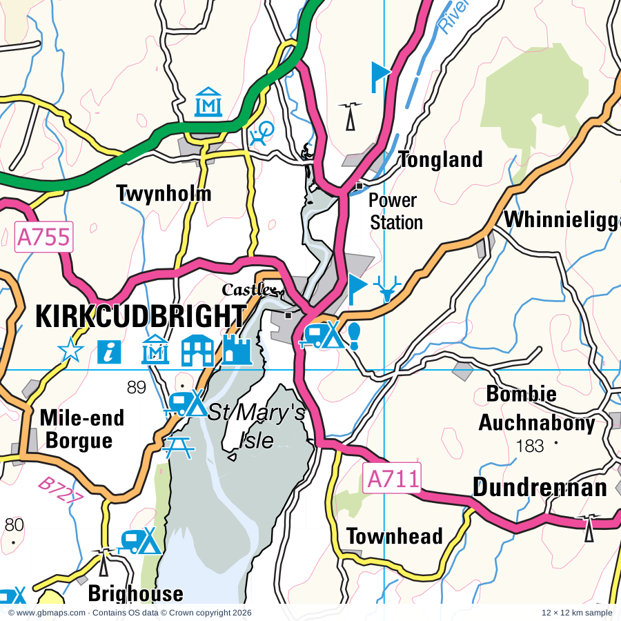
Explore the full 60 × 60 km Kirkcudbright regional road map at 1:250,000, covering Dalbeattie, Whithorn, Wigtown, Whitehaven, Balmae. Compare the complete coverage below; a detailed PDF sample is available free.

KIRKCUDBRIGHT & SURROUNDING AREAREGIONAL ROAD MAP
60 × 60 km · Full map previewDownload the free SVG ↓

INSIDE THE FULL 60 × 60 KM MAP

Explore the Kirkcudbright map area

1:250,000 cartography

Towns, villages & places

  • Dalbeattie
  • Whithorn
  • Wigtown
  • Whitehaven
  • Balmae
  • Townhead
  • Dundrennan
  • Borgue
  • Kirkandrews
  • Tongland
  • Twynholm
  • Auchencairn
  • Knockbrex
  • Girthon
  • Sandgreen
  • Ringford
  • Gelston
  • Anwoth
More mapped places (43)
  • Kelton Hill
  • Rockcliffe
  • Kippford
  • Palnackie
  • Colvend
  • Isle of Whithorn
  • Garlieston
  • Sandyhills
  • Glenlochar
  • Laurieston
  • Carsluith
  • Clarebrand
  • Sorbie
  • Crossmichael
  • Caulkerbush
  • Glasserton
  • Hardgate
  • Creetown
  • Kirkinner
  • Mainsriddle
  • Braehead
  • Southerness
  • Bladnoch
  • Whauphill
  • Kirkgunzeon
  • Springholm
  • Prestonmill
  • Grayson Green
  • Lowca
  • Kirkbean
  • Palnure
  • Parton
  • Causeway End
  • Howgate
  • Stronord
  • Beeswing
  • Carsethorn
  • Sandwith
  • New Abbey
  • Overton
  • Rottington
  • St Bees
  • Glencaple

Roads across this sheet

A596, A597, A710, A711, A712, A713, A714, A745, A746, A747, A755, A762, A5094, B725, B727, B733, B736, B793, B794, B795, B796, B5295, B5296, B5297

More road numbers

B5306, B5345, B7004, B7005, B7021, B7052, B7079, B7085

Rivers & waterways

Big Water of Fleet, Palnure Burn, Penkiln Burn, River Bladnoch, River Cree, River Dee, River Dee or Black Water of Dee, River Derwent, Urr Water

Landmarks & landscape

Arbigland Estate, Barnbarroch Pottery, Bellymack Hill Farm Kite Feeding Station, Bladnoch Distillery, Broughton House & Garden, Cairnholy, Cairnsmoor of Fleet, Cally Gardens, Cardoness Castle, Carlingwark Loch, Carsluith Castle, Carstramon Wood Nature Reserve, GALLOWAY FOREST PARK

More named features

Cocao Chocolate Factory, Cream o'Galloway, Dalbeattie Museum, David Coulthard Museum, Dromore Farm Visitor Centre, Drumcoltran Tower, Dundrennan Abbey, Galloway House Gardens, Galloway Wildlife Conservation Park, Garlies Castle, Gem Rock Museum, Creetown Exhibition Centre, Glasserton Mains Cottage, Kiltmaker, Kirkconnell Tower, Kirroughtree Visitor Centre, Maclellan's Castle, Mainsriddle Pottery, Meal Mill, Mote of Mark, Newton Stewart Museum, Dolls House Museum, North Glen Glass, Orchardton, Paul Jones Cottage, Plantain Loch Nature Reserve, Power Station, Rispain Camp, Shambellie House, Sorbie Tower, St Bees Head Nature Reserve, St Ninian's Cave, St Ninian's Chapel, Stewartry Museum, Sweetheart Abbey, The Beacon, The Rum Story, Haig Colliery Mining Museum, Threave Castle, Threave Garden and Estate, Threave House, Tolbooth Art Centre, Tower, Trinity Gardens and Labyrinth, Visitor Centre, Visitor Centre, The Mill on the Fleet, Whithorn Priory, Whithorn Priory Visitor Centre, Wigton Off Road Driving Centre, Wigtown Bay Local Nature Reserve
Local authority & parish coverage

Wholly or partly within the full map rectangle. These boundaries are coverage information, not additional artwork layers.

  • CumberlandPartly within
  • Dumfries and GallowayPartly within
Wards & electoral divisions 16 areas
  • Abbey Ward (part)
  • Bransty Ward
  • Castle Douglas and Crocketford Ward (part)
  • Dee and Glenkens Ward (part)
  • Egremont North and St. Bees Ward (part)
  • Egremont Ward (part)
  • Harrington Ward (part)
  • Hillcrest and Hensingham Ward (part)
  • Howgate Ward (part)
  • Kells and Sandwith Ward
  • Mid Galloway and Wigtown West Ward (part)
  • Mirehouse Ward
  • Moss Bay and Moorclose Ward (part)
  • Nith Ward (part)
  • Seaton Ward (part)
  • St. Michael's Ward (part)
Civil parishes & communities 10 areas
  • Distington CP (part)
  • Egremont CP (part)
  • Lowca CP (part)
  • Moresby CP (part)
  • Parton CP
  • Seaton CP (part)
  • St. Bees CP (part)
  • Weddicar CP (part)
  • Whitehaven CP (part)
  • Workington CP (part)

Source: the GBMaps road atlas, OS Boundary-Line and postcode mapping datasets. Source editions are being checked for publication. Unmarked boundary names are wholly within the sheet; “part” means the map edge crosses the area.

Place lists are selected from the map source, not a complete gazetteer. Named features describe the cartography; visitor facilities and opening status are not verified. The free sample covers only 12 × 12 km of this larger sheet.

INSIDE YOUR DOWNLOAD

A proper road map, in useful formats

Road classifications, towns and villages, railways, rivers, landscape detail and tourist symbols, brought together in the GBMaps regional road atlas style.

PDF filePDFSVG fileSVGAdobe Illustrator AI fileAi

PDF for the finished map. SVG and layered Illustrator artwork for adapting colours, adding your own information and preparing designs.

THE FINISHED SHEET

Designed for print and presentation

Map coverage
60 × 60 km
Sample coverage
12 × 12 km
Print layout
A3 landscape · enlarged 1:250k cartography
Sheet furniture
Border, scale bar, key & north arrow

A few useful details

What changes when I select another square?

Select a surrounding square to bring it into the centre and reveal the maps around it. Each square is a different 60 × 60 km map. The preview, free sample and selected download change together. Neighbouring sheets overlap by 30 km so you can choose the coverage that suits you.

Is the free sample a vector map?

The on-page detail is an SVG. The free download is a separate 12 × 12 km PDF with a link to the full map. Please retain its copyright credits and product link when sharing it.

Can I buy a larger combined map?

These downloads are individual ready-made sheets. Contact GBMaps if you need a larger combined area.

FREE PDF SAMPLE

Your free map sample

Your free 12 × 12 km sample includes a link back to this map, so you can return for the full area whenever you need it.

Download free PDF sample ↓

Get your Kirkcudbright map

Map download bundle

£24.00including VATOne payment

Pay securely

One payment. Your map stays open.

Your map download

Your map files

Preparing your download…

Checking your private download link…

Your map downloads

Already bought a map?

Find the downloads from your purchases.

Enter the email address you used at checkout. We’ll email you a private link to your available map downloads.