Innerleithen regional road map. Full 60 × 60 km PDF, SVG and Illustrator files, with a free PDF sample.

GBMAPS.COM

Innerleithen Regional Road Map

Call Us Now for Help01751 473136

GREAT BRITAIN ROAD ATLAS · 1:250,000 GB-330-0630

Innerleithen & surrounding area

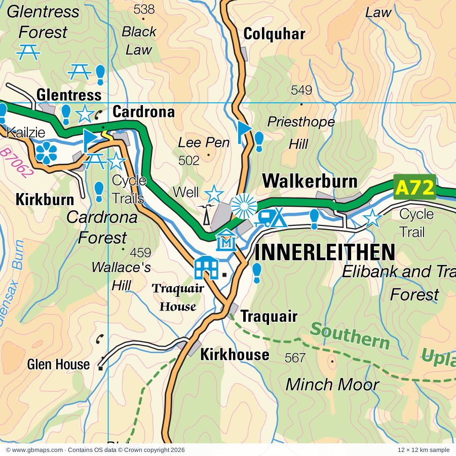
Explore the full 60 × 60 km Innerleithen regional road map at 1:250,000, covering Innerleithen, Peebles, Selkirk, Galashiels, Melrose. Compare the complete coverage below; a detailed PDF sample is available free.

INNERLEITHEN & SURROUNDING AREAREGIONAL ROAD MAP
60 × 60 km · Full map previewDownload the free SVG ↓

INSIDE THE FULL 60 × 60 KM MAP

Explore the Innerleithen map area

1:250,000 cartography

Towns, villages & places

More mapped places (69)
  • Ettrick
  • Clovenfords
  • Drumelzier
  • Birkhill
  • Stanhope
  • Eddleston
  • Ashkirk
  • Lindean
  • Broughton
  • Buckholm
  • Boleside
  • Roberton
  • Tweedsmuir
  • Stow
  • Killochyett
  • Craik
  • Romannobridge
  • Midlem
  • Fountainhall
  • Langshaw
  • Darnick
  • Lilliesleaf
  • Lamancha
  • Skirling
  • Heriot
  • Branxholme
  • Gattonside
  • Newmill
  • Appletreehall
  • Bowden
  • Candy Mill
  • Leadburn
  • Newstead
  • West Linton
  • Dolphinton
  • Hassendean
  • Heriot
  • Teviothead
  • Elsrickle
  • Coulter
  • Cavers
  • Charlesfield
  • Davington
  • Minto
  • Longnewton
  • Howgate
  • Walston
  • Middleton
  • Temple
  • Earlston
  • Redpath
  • Dunsyre
  • Denholm
  • Carlops
  • Kirkton
  • St Boswells
  • Gilston
  • Bemersyde
  • Nine Mile Burn
  • Borthwick
  • Oxton
  • Newton
  • Legerwood
  • Bedrule
  • Newbigging
  • Hobkirk
  • Cleuch Head
  • Beattock
  • Tarbrax

Roads across this sheet

A7, A70, A72, A74(M), A697, A698, A699, A701, A703, A707, A708, A721, A766, A6088, A6089, A6094, A6105, B709, B710, B711, B712, B719, B6340, B6356

More road numbers

B6357, B6358, B6359, B6360, B6361, B6362, B6367, B6368, B6372, B6374, B6394, B6397, B6398, B6399, B6400, B6404, B6405, B6453, B6458, B7007, B7008, B7009, B7014, B7016, B7026, B7039, B7059, B7060, B7062, B7076

Rivers & waterways

Ale Water, Allan Water, Birnock Water, Black Esk, Blackhope Burn, Borthwick Water, Caddon Water, Camps Water, Cornal Burn, Culter Water, Dryfe Water, Dye Water

More waterways

Eddleston Water, Ettrick Water, Gala Water, Garpol Water, Glensax Burn, Holms Water, Kinnel Water, Leader Water, Leithen Water, Lochan Burn, Lugate Water, Lyne Water, Manor Water, Meggat Water, Moffat Water, North Medwin, River Annan, River Clyde, River North Esk, River South Esk, River Teviot, River Tweed, Selcoth Burn, Slitrig Water, Soonhope Burn, South Medwin, Tyne Water, Wamphray Water, White Esk, Yarrow Water

Landmarks & landscape

AD Pottery, Abbotsford, Aikwood Tower, Arniston House, Auchen Castle, Beltane Studios, Bemersyde Gardens, Biggar Gasworks Museum, Greenhill Covenanters House, Museum of Biggar & Upper Clydesdale, Bore Stane, Bowhill, Branxholm Park, Broch

More named features

Cardrona Cycle Trails, Celtic Goldsmith, Coulter Motte Hill, Crook Inn, Cross Kirk - Peebles, Cycle Trail, Dawyck Botanic Garden, Dawyck House, Douglas Davies Gallery, Drochil Castle, Dryburgh Abbey, Dun Law, Eildontree Stone, Ellbank & Traquair Forest Cycle Trails, Glen House, Granton House, Grey Mare's Tail (waterfalls), Grey Mare's Tail Nature Reserve, Halliwell's House, Robert Clapperton's Photographic Studio, Hare Faulds, Harmony Garden, Hawick Museum, Drumlanrig's Tower, Hotel, John Buchan Centre, Kagyu Samye Ling Monastery and Tibetan Centre, Kailzie, Lindean Mill Glass, Melrose Abbey, Moffat Museum, Moffat Woollen Mill, Motte, Neidpath Castle, Newark Castle, Old Gala House, Posso Settlement (rems of), Priorwood Garden, ROMAN FORT, ROMAN FORTLET, Robert Smail's Printing Works, Scottish Borders Art Glass, Sir Walter Scott's Courtroom, Soutra Aisle, St Ronan's Wells Centre, Cashmere Country, Stobo Castle, TRIMONTIVM, The Scottish Borders Donkey Sanctuary, Thirlestane Castle, Tibbie Shiels Inn, Tinnis Castle, Traquair House, Tweed Valley Forest Park Visitor Centre, Tweeddale Museum and Art Gallery, The Cornice Museum, Tweeds Well, Wallace Statue, Waverley Mill, Whitmuir The Organic Place Farm, Whitrope Heritage Centre
Local authority & parish coverage

Wholly or partly within the full map rectangle. These boundaries are coverage information, not additional artwork layers.

  • City of EdinburghPartly within
  • Dumfries and GallowayPartly within
  • East LothianPartly within
  • MidlothianPartly within
  • Scottish BordersPartly within
  • South LanarkshirePartly within
  • West LothianPartly within
Wards & electoral divisions 20 areas
  • Annandale East and Eskdale Ward (part)
  • Annandale North Ward (part)
  • Clydesdale East Ward (part)
  • Clydesdale North Ward (part)
  • East Livingston and East Calder Ward (part)
  • Fauldhouse and the Breich Valley Ward (part)
  • Galashiels and District Ward
  • Haddington and Lammermuir Ward (part)
  • Hawick and Denholm Ward (part)
  • Hawick and Hermitage Ward (part)
  • Jedburgh and District Ward (part)
  • Leaderdale and Melrose Ward (part)
  • Mid Berwickshire Ward (part)
  • Midlothian East Ward (part)
  • Midlothian South Ward (part)
  • Penicuik Ward (part)
  • Pentland Hills Ward (part)
  • Selkirkshire Ward
  • Tweeddale East Ward
  • Tweeddale West Ward
Civil parishes & communities 0 areas

    Source: the GBMaps road atlas, OS Boundary-Line and postcode mapping datasets. Source editions are being checked for publication. Unmarked boundary names are wholly within the sheet; “part” means the map edge crosses the area.

    Place lists are selected from the map source, not a complete gazetteer. Named features describe the cartography; visitor facilities and opening status are not verified. The free sample covers only 12 × 12 km of this larger sheet.

    INSIDE YOUR DOWNLOAD

    A proper road map, in useful formats

    Road classifications, towns and villages, railways, rivers, landscape detail and tourist symbols, brought together in the GBMaps regional road atlas style.

    PDF filePDFSVG fileSVGAdobe Illustrator AI fileAi

    PDF for the finished map. SVG and layered Illustrator artwork for adapting colours, adding your own information and preparing designs.

    THE FINISHED SHEET

    Designed for print and presentation

    Map coverage
    60 × 60 km
    Sample coverage
    12 × 12 km
    Print layout
    A3 landscape · enlarged 1:250k cartography
    Sheet furniture
    Border, scale bar, key & north arrow

    A few useful details

    What changes when I select another square?

    Select a surrounding square to bring it into the centre and reveal the maps around it. Each square is a different 60 × 60 km map. The preview, free sample and selected download change together. Neighbouring sheets overlap by 30 km so you can choose the coverage that suits you.

    Is the free sample a vector map?

    The on-page detail is an SVG. The free download is a separate 12 × 12 km PDF with a link to the full map. Please retain its copyright credits and product link when sharing it.

    Can I buy a larger combined map?

    These downloads are individual ready-made sheets. Contact GBMaps if you need a larger combined area.

    FREE PDF SAMPLE

    Your free map sample

    Your free 12 × 12 km sample includes a link back to this map, so you can return for the full area whenever you need it.

    Download free PDF sample ↓

    Get your Innerleithen map

    Map download bundle

    £24.00including VATOne payment

    Pay securely

    One payment. Your map stays open.

    Your map download

    Your map files

    Preparing your download…

    Checking your private download link…

    Your map downloads

    Already bought a map?

    Find the downloads from your purchases.

    Enter the email address you used at checkout. We’ll email you a private link to your available map downloads.