Harrogate & Wharfedale regional road map. Full 60 × 60 km PDF, SVG and Illustrator files, with a free PDF sample.

GBMAPS.COM

Harrogate & Wharfedale Regional Road Map

Call Us Now for Help01751 473136

GREAT BRITAIN ROAD ATLAS · 1:250,000 RY-01W

Harrogate & Wharfedale

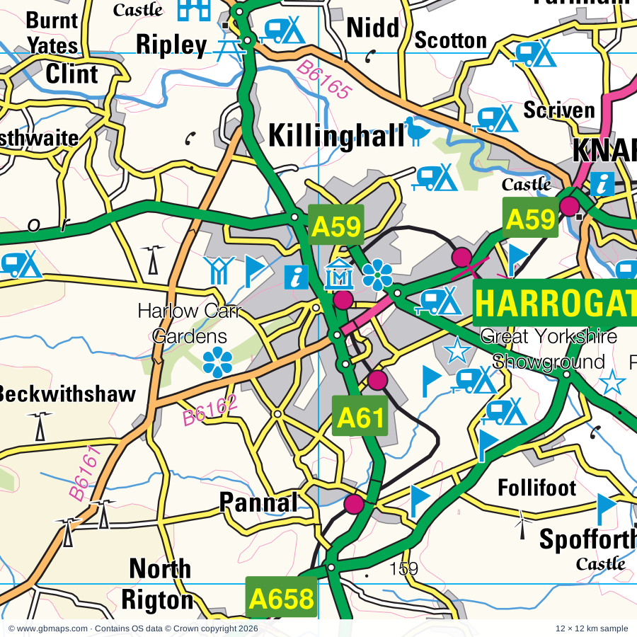
Explore the full 60 × 60 km Harrogate & Wharfedale regional road map at 1:250,000, covering Otley, Guiseley, Ilkley, Yeadon, Baildon. Compare the complete coverage below; a detailed PDF sample is available free.

HARROGATE & WHARFEDALEREGIONAL ROAD MAP
60 × 60 km · Full map previewDownload the free SVG ↓

INSIDE THE FULL 60 × 60 KM MAP

Explore the Harrogate & Wharfedale map area

1:250,000 cartography

Towns, villages & places

More mapped places (251)

Roads across this sheet

M1, M62, M606, M621, A1(M), A19, A56, A58, A58(M), A59, A61, A62, A63, A64, A64(M), A65, A162, A167, A168, A628, A629, A636, A638, A639

More road numbers

A641, A642, A643, A644, A645, A646, A647, A649, A650, A651, A652, A653, A654, A655, A656, A657, A658, A659, A660, A661, A681, A1246, A6025, A6026, A6029, A6032, A6033, A6034, A6035, A6036, A6037, A6038, A6040, A6055, A6068, A6069, A6107, A6108, A6110, A6120, A6131, A6139, A6142, A6176, A6177, A6181, A6539, B1217, B1222, B1223, B1224, B1448, B6112, B6113, B6114, B6117, B6118, B6119, B6120, B6121, B6122, B6123, B6124, B6125, B6126, B6127, B6128, B6129, B6133, B6134, B6135, B6136, B6137, B6138, B6141, B6142, B6143, B6144, B6145, B6146, B6147, B6149, B6151, B6152, B6153, B6154, B6155, B6156, B6157, B6159, B6160, B6161, B6162, B6163, B6164, B6165, B6172, B6250, B6252, B6265, B6267, B6269, B6379, B6380, B6381, B6382, B6383, B6409, B6421, B6429, B6451, B6475, B6481

Rivers & waterways

Aire & Calder Navigation, Calder & Hebble Navigation, Cock Beck, Cod Beck, Eller Beck, Hebden Water, How Stean Beck, Huddersfield Broad Canal, Kex Beck, Leeds & Liverpool Canal, Milby Cut, Ripon Canal

More waterways

River Aire, River Calder, River Dibb, River Laver, River Nidd, River Ouse, River Skirfare, River Swale, River Ure, River Washburn, River Wharfe, River Worth, Rochdale Canal

Landmarks & landscape

Abbey House Museum, Aire Head, Aisled Barn Visitor Centre, Aldborough Museum, Aldborough Roman Town (ISVRIVM), Allerton Park, Armley Mills Museum, Bagshaw Museum, Baildon Craft Centre, Bankfield Museum, Barden Tower, Barden Tower (remains of), YORKSHIRE DALES NATIONAL PARK

More named features

Bingley Five Rise Locks, Birchwood Museum, Bird Attraction, Bird Gardens,Sanctuaries,Birds of, Bolling Hall Museum, Bolton Priory, Bracken Hall Countryside Centre, Shipley Glen Tramway, Bradford Cathedral, Bradford Industrial Museum & Horses at Work, Bramham Park, Bramham Park Gardens, Brimham Rocks, Bronte Parsonage Museum, Bronte Weaving Shed, Burton Leonard Quarries, Cartwright Hall Art Gallery and Museum, Castle, Castleford Museum, Centre Vale Park, Cliffe Castle, Keighley Bus Museum, Copper Dragon Brewery Visitor Centre, Courthouse Museum, Craven Museum, Crimsworth Dean, Dean Clough Gallery, Square Chapel Centre for the Arts, Piece Hall Arts Gallery, Dewsbury Minster Heritage Centre, Dewsbury Museum, Diggerland (Yorkshire), Earby Museum Of Mines, East Riddlesden Hall, Embsay Steam Railway, Eureka The Museum for Children, Fairburn Ings Nature Reserve, Fairburn Ings Visitor Centre, Fountains Abbey, Fountains Hall, Garden, Glissing Centre, Wakefield Museum, Golden Acre Park and Gardens, Gordale Scar, Great Yorkshire Showground, Grimwith Reservoir Beauty Spot, Hall, Hardcastle Crags, Harewood House, Harewood House Bird Garden, Harewood House and Garden, Harlow Carr Botanical Garden, Heptonstall, Hesketh Farm Park, Higher & Lower Holme House Woods, Historic Milestones, Home Farm, Horsforth Village Museum, Horton Bank Country Park, How Stean Gorge, ISVRIVM, Janet's Foss, Keighley & Worth Valley Railway, Killinghall Moor Country Park, Kilnsey Crag, Kilnsey Park, Kirkstall Abbey, Knaresborough Castle, Leeds Cathedral, Leeds Metropolitan University Gallery, Leeds City Art Gallery, Lightwater Valley, Linton Falls, Littlethorpe Potteries, Lotherton Hall, Lotherton Hall Deer Park, Lotherton Hall Bird Garden, Lotherton Hall Formal Gardens, Lower Grass Wood Nature Reserve, Lumb Hole Waterfall, Manor Heath Park Garden, Manor House Museum (Ilkley Manor House), Markenfield Hall, Marmion Tower, Meanwood Valley Urban Farm, Middleton Park Visitor Centre, Middleton Railway, Moravian Museum, National Media Museum, Newby Hall, Newby Hall & Gardens, Nidd Gorge Nature Reserve, Nidderdale Museum, Norton Conyers, Nosterfield Nature Reserve, Oakwell Hall, Oakwell Hall Country Park, Ogden Water Country Park, Ogden Water Visitor Centre, Parcevall Hall Garden, Penistone Hill Country Park, Phillis Harvey Horse & Donkey Trust, Planet Earth Centre, Plumpton Rocks, Ponderosa Rural Therapeutic Centre & Rare Breeds Farm, Pontefract Castle, Pontefract Museum, Pontefract Racecourse, ROMAN FORT, Railway Carriage Museum, Ripley Castle, Ripley Castle and Gardens, Ripon Cathedral, Ripon Prison & Police Museum, Workhouse Museum, The Courthouse, Ripon Racecourse, Rodley Nature Reserve, Roundhay Park, Royal Armouries Museum, Leeds Museum Discovery Centre, Leeds City Museum, Saltaire (World Heritage Site), Scoska Wood, Shibden Hall, Shibden Park, Skipton Castle, Smith Art Gallery, Spofforth Castle, St Aldan's Nature Reserve Point & Visitor Centre, St Mary's Church, Stanley Marsh Local Nature Reserve, Steam Train Museum, Steeton Hall Gatehouse, Stockeld Park, Stoodley Pike Monument, Studley Hall Water Garden, Studley Park, Studley Royal & Fountains Abbey (World Heritage Site), Temple Newsam Country Park, Temple Newsam House, Thackray Medical Museum, The Cathedral Church of All Saints, The Darley Mill Centre, The Hepworth Wakefield, The Minster, The Red House Museum, The Royal Pump Room, Quilt Museum and Gallery, Thornton Hall Farm, Thorpe Prebend House, Thwaite Mills Industrial Museum, Trollers Gill, Tropical World, Upper Wharfedale Folk Museum, Valley Gardens, Visitor & Canal Centre, Visitor Centre, Wetherby Racecourse, Wycoller Country Park, Xscape (Castleford), Yorkshire Craft Centre
Local authority & parish coverage

Wholly or partly within the full map rectangle. These boundaries are coverage information, not additional artwork layers.

  • Bradford DistrictWholly within
  • Burnley DistrictPartly within
  • Calderdale DistrictPartly within
  • Kirklees DistrictPartly within
  • Leeds DistrictWholly within
  • North YorkshirePartly within
  • Pendle DistrictPartly within
  • Rochdale DistrictPartly within
  • Rossendale DistrictPartly within
  • Wakefield DistrictPartly within
Wards & electoral divisions 159 areas
  • Ackworth, North Elmsall & Upton Ward (part)
  • Adel & Wharfedale Ward
  • Airedale & Ferry Fryston Ward
  • Airedale Ward
  • Altofts & Whitwood Ward
  • Alwoodley Ward
  • Ardsley & Robin Hood Ward
  • Armley Ward
  • Ashbrow Ward (part)
  • Baildon Ward
  • Batley East Ward
  • Batley West Ward
  • Beeston & Holbeck Ward
  • Bingley East Ward
  • Bingley West Ward
  • Birstall & Birkenshaw Ward
  • Bolton & Undercliffe Ward
  • Boulsworth & Foulridge Ward (part)
  • Bowling & Barkerend Ward
  • Bradford Moor Ward
  • Bramley & Stanningley Ward
  • Briercliffe Ward (part)
  • Brighouse Ward
  • Burmantofts & Richmond Hill Ward
  • Calverley & Farsley Ward
  • Castleford Central & Glasshoughton Ward
  • Chapel Allerton Ward
  • City Ward
  • Clayton & Fairweather Green Ward
  • Cleckheaton Ward
  • Cliviger with Worsthorne Ward (part)
  • Cross Gates & Whinmoor Ward
  • Dalton Ward (part)
  • Dewsbury East Ward
  • Dewsbury South Ward (part)
  • Dewsbury West Ward (part)
  • Earby & Coates Ward (part)
  • Eccleshill Ward
  • Elland Ward (part)
  • Farnley & Wortley Ward
  • Featherstone Ward (part)
  • Garforth & Swillington Ward
  • Gipton & Harehills Ward
  • Great Horton Ward
  • Greetland Ward (part)
  • Guiseley & Rawdon Ward
  • Halifax Town Ward
  • Harewood Ward
  • Headingley & Hyde Park Ward
  • Heaton & Frizinghall Ward
  • Hebden Bridge & Todmorden East Ward (part)
  • Heckmondwike Ward
  • Hipperholme & Lightcliffe Ward
  • Holme Wood & Bierley Ward
  • Horbury & South Ossett Ward (part)
  • Horsforth Ward
  • Hunslet & Riverside Ward
  • Idle & Thackley Ward
  • Ilkley & Addingham Ward
  • Illingworth & Mixenden Ward
  • Keighley Central Ward
  • Keighley East Ward
  • Keighley West Ward
  • Killingbeck & Seacroft Ward
  • Kippax & Methley Ward
  • Kirkstall Ward
  • Knottingley & Ferrybridge Ward (part)
  • Little Horton Ward
  • Little London & Woodhouse Ward
  • Littleborough Lakeside Ward (part)
  • Liversedge & Gomersal Ward
  • Luddendenfoot Ward (part)
  • Manningham Ward
  • Marsden & Southfield Ward (part)
  • Middleton Park Ward
  • Mirfield Ward (part)
  • Moortown Ward
  • Morley North Ward
  • Morley South Ward
  • Normanton Ward (part)
  • Northowram & Shelf Ward
  • Ossett Ward (part)
  • Otley & Yeadon Ward
  • Ovenden Ward
  • Park Ward
  • Pontefract North Ward
  • Pontefract South Ward (part)
  • Pudsey Ward
  • Queensbury Ward
  • Rastrick Ward
  • Rothwell Ward
  • Roundhay Ward
  • Royds Ward
  • Ryburn Ward (part)
  • Salterhebble, Southowram & Skircoat Green Ward
  • Shipley Ward
  • Sowerby Bridge Ward
  • Stanley & Outwood East Ward
  • Temple Newsam Ward
  • Thornton & Allerton Ward
  • Todmorden West Ward (part)
  • Toller Ward
  • Wainhouse Ward
  • Wakefield East Ward (part)
  • Wakefield North Ward
  • Wakefield West Ward (part)
  • Wardle, Shore & West Littleborough Ward (part)
  • Warley Ward
  • Waterside & Horsfield Ward (part)
  • Weetwood Ward
  • Wetherby Ward
  • Wharfedale Ward
  • Whitworth Ward (part)
  • Wibsey & Odsal Ward
  • Windhill & Wrose Ward
  • Worth Valley Ward
  • Wrenthorpe & Outwood West Ward
  • Wyke Ward
  • Aire Valley ED
  • Appleton Roebuck & Church Fenton ED (part)
  • Bedale ED (part)
  • Bilton & Nidd Gorge ED
  • Bilton Grange & New Park ED
  • Boroughbridge & Claro ED
  • Coppice Valley & Duchy ED
  • Easingwold ED (part)
  • Fairfax & Starbeck ED
  • Glusburn, Cross Hills & Sutton-in-Craven ED
  • Harlow & St Georges ED
  • High Harrogate & Kingsley ED
  • Hillside & Raskelf ED (part)
  • Huby & Tollerton ED (part)
  • Killinghall, Hampsthwaite & Saltergate ED
  • Knaresborough East ED
  • Knaresborough West ED
  • Leyburn & Middleham ED (part)
  • Masham & Fountains ED (part)
  • Mid Craven ED (part)
  • Monk Fryston & South Milford ED (part)
  • Oatlands & Pannal ED
  • Osgoldcross ED (part)
  • Ouseburn ED (part)
  • Pateley Bridge & Nidderdale ED
  • Ripon Minster & Moorside ED
  • Ripon Ure Bank & Spa ED
  • Sherburn in Elmet ED (part)
  • Skipton East & South ED
  • Skipton North & Embsay-with-Eastby ED
  • Skipton West & West Craven ED (part)
  • Sowerby & Topcliffe ED (part)
  • Spofforth with Lower Wharfedale & Tockwith ED
  • Stray, Woodlands & Hookstone ED
  • Tadcaster ED (part)
  • Thirsk ED (part)
  • Upper Dales ED (part)
  • Valley Gardens & Central Harrogate ED
  • Washburn & Birstwith ED
  • Wathvale & Bishop Monkton ED (part)
  • Wharfedale ED (part)
Civil parishes & communities 339 areas
  • Aberford CP
  • Addingham CP
  • Ainderby Quernhow CP (part)
  • Airton CP (part)
  • Aldfield CP
  • Aldwark CP
  • Allerton Bywater CP
  • Allerton Mauleverer with Hopperton CP
  • Alne CP (part)
  • Alwoodley CP
  • Appletreewick CP
  • Arkendale CP
  • Arncliffe CP (part)
  • Arthington CP
  • Asenby CP
  • Askwith CP
  • Austhorpe CP
  • Azerley CP
  • Bagby CP (part)
  • Baildon CP
  • Baldersby CP (part)
  • Balk CP (part)
  • Bank Newton CP (part)
  • Barden CP
  • Bardsey cum Rigton CP
  • Barkston Ash CP (part)
  • Barwick in Elmet and Scholes CP
  • Beamsley CP
  • Beckwithshaw CP
  • Bewerley CP
  • Bilton-in-Ainsty with Bickerton CP
  • Bingley CP
  • Birdforth CP
  • Birstwith CP
  • Bishop Monkton CP
  • Bishop Thornton, Shaw Mills and Warsill CP
  • Bishopdale CP (part)
  • Blackshaw CP
  • Blubberhouses CP
  • Bolton Abbey CP
  • Boroughbridge CP
  • Boston Spa CP
  • Bradleys Both CP
  • Brafferton and Helperby CP
  • Bramham cum Oglethorpe CP
  • Bramhope CP
  • Brearton CP
  • Bridge Hewick CP
  • Briercliffe CP (part)
  • Brotherton CP (part)
  • Broughton CP
  • Buckden CP (part)
  • Burley CP
  • Burnsall CP
  • Burton Leonard CP
  • Burton Salmon CP (part)
  • Burton-cum-Walden CP (part)
  • Burton-on-Yore CP (part)
  • Byram cum Sutton CP (part)
  • Calton CP
  • Carleton CP
  • Carlton CP
  • Carlton Highdale CP (part)
  • Carlton Husthwaite CP (part)
  • Carlton Miniott CP (part)
  • Castley CP
  • Cattal CP
  • Catterton CP (part)
  • Catton CP
  • Clayton CP
  • Clifford CP
  • Clint cum Hamlets CP
  • Cliviger CP (part)
  • Collingham CP
  • Colne CP (part)
  • Colsterdale CP (part)
  • Coneythorpe and Clareton CP
  • Coniston Cold CP (part)
  • Conistone with Kilnsey CP
  • Cononley CP
  • Copgrove CP
  • Copt Hewick CP
  • Cowling CP
  • Cracoe CP
  • Cridling Stubbs CP (part)
  • Cross Roads CP
  • Cullingworth CP
  • Cundall with Leckby CP
  • Dacre CP
  • Dalton CP
  • Darley and Menwith CP
  • Darrington CP (part)
  • Denholme CP
  • Denton CP
  • Dishforth CP
  • Draughton CP
  • Drighlington CP
  • Dunsforths CP
  • Earby CP (part)
  • Easingwold CP (part)
  • East Keswick CP
  • East Tanfield CP (part)
  • Eavestone CP
  • Eldmire with Crakehill CP
  • Ellenthorpe CP
  • Elslack CP
  • Embsay with Eastby CP
  • Erringden CP
  • Eshton CP
  • Fairburn CP
  • Farnham CP
  • Farnhill CP
  • Farnley CP
  • Fawdington CP
  • Fearby CP (part)
  • Featherstone CP (part)
  • Felliscliffe CP
  • Ferrensby CP
  • Fewston CP
  • Flasby with Winterburn CP
  • Flawith CP
  • Flaxby CP
  • Follifoot CP
  • Foulridge CP (part)
  • Fountains Earth CP
  • Gargrave CP
  • Gildersome CP
  • Givendale CP
  • Glusburn and Cross Hills CP
  • Goldsborough CP
  • Grantley CP
  • Grassington CP
  • Great Ouseburn CP
  • Great Ribston with Walshford CP
  • Great Timble CP
  • Great and Little Preston CP
  • Green Hammerton CP
  • Grewelthorpe CP
  • Grimston CP (part)
  • Halton East CP
  • Hampsthwaite CP
  • Hanlith CP (part)
  • Harden CP
  • Harewood CP
  • Harrogate CP
  • Hartlington CP
  • Hartwith cum Winsley CP
  • Haverah Park CP
  • Hawkswick CP
  • Haworth and Stanbury CP
  • Hazlewood with Storiths CP
  • Healaugh CP (part)
  • Healey CP (part)
  • Hebden CP
  • Hebden Royd CP (part)
  • Heptonstall CP
  • Hetton-cum-Bordley CP
  • High and Low Bishopside CP
  • Hillam CP (part)
  • Horsforth CP
  • Howe CP (part)
  • Howgrave CP (part)
  • Huddleston with Newthorpe CP
  • Humberton CP
  • Hunsingore CP
  • Huntwick with Foulby and Nostell CP (part)
  • Husthwaite CP (part)
  • Hutton Conyers CP
  • Hutton-Sessay CP
  • Ilkley CP
  • Ilton-cum-Pott CP (part)
  • Kearby with Netherby CP
  • Keighley CP
  • Kelbrook and Sough CP (part)
  • Kettlewell with Starbotton CP
  • Kilburn High and Low CP (part)
  • Kildwick CP
  • Killinghall CP
  • Kippax CP
  • Kirby Hall CP
  • Kirby Hill CP
  • Kirk Deighton CP
  • Kirk Hammerton CP
  • Kirkburton CP (part)
  • Kirkby Malham CP (part)
  • Kirkby Malzeard CP
  • Kirkby Overblow CP
  • Kirkby Wharfe with North Milford CP (part)
  • Kirklington-cum-Upsland CP (part)
  • Knaresborough CP
  • Laneshaw Bridge CP
  • Langthorpe CP
  • Laverton CP
  • Lead CP
  • Leathley CP
  • Ledsham CP
  • Lindley CP
  • Lindrick with Studley Royal and Fountains CP
  • Linton CP
  • Linton-on-Ouse CP (part)
  • Little Ouseburn CP
  • Little Ribston CP
  • Little Timble CP
  • Littlethorpe CP
  • Litton CP (part)
  • Long Marston CP (part)
  • Lothersdale CP
  • Lotherton cum Aberford CP
  • Malham CP (part)
  • Malham Moor CP (part)
  • Markenfield Hall CP
  • Markington with Wallerthwaite CP
  • Marton cum Grafton CP
  • Marton-le-Moor CP
  • Martons Both CP (part)
  • Masham CP (part)
  • Melmerby CP
  • Menston CP
  • Micklefield CP
  • Middleton CP
  • Middleton Quernhow CP (part)
  • Milby CP
  • Mirfield CP (part)
  • Monk Fryston CP (part)
  • Moor Monkton CP (part)
  • Morley CP
  • Myton-on-Swale CP
  • Nelson CP (part)
  • Nesfield with Langbar CP
  • Newall with Clifton CP
  • Newby with Mulwith CP
  • Newland with Woodhouse Moor CP
  • Newton Kyme cum Toulston CP
  • Nidd CP
  • Normanton and Altofts CP
  • North Deighton CP
  • North Rigton CP
  • North Stainley with Sleningford CP
  • Norton Conyers CP
  • Norton-le-Clay CP
  • Norwood CP
  • Nun Monkton CP (part)
  • Otley CP
  • Oxenhope CP
  • Oxton CP (part)
  • Pannal and Burn Bridge CP
  • Parlington CP
  • Plompton CP
  • Pool CP
  • Rainton with Newby CP
  • Raskelf CP (part)
  • Rawdon CP
  • Ripley CP
  • Ripon CP
  • Ripponden CP (part)
  • Roecliffe CP
  • Rylstone CP
  • Salterforth CP (part)
  • Sandy Lane CP
  • Sawley CP
  • Saxton with Scarthingwell CP (part)
  • Scarcroft CP
  • Scosthrop CP (part)
  • Scotton CP
  • Scriven CP
  • Sessay CP
  • Shadwell CP
  • Sharlston CP (part)
  • Sharow CP
  • Sherburn in Elmet CP (part)
  • Shipley CP
  • Sicklinghall CP
  • Silsden CP
  • Skelding CP
  • Skelton-on-Ure CP
  • Skipton CP
  • Skipton-on-Swale CP (part)
  • South Milford CP (part)
  • South Stainley with Cayton CP
  • Sowerby CP (part)
  • Spofforth with Stockeld CP
  • Stainburn CP
  • Stainland and District CP (part)
  • Staveley CP
  • Steeton with Eastburn CP
  • Stirton with Thorlby CP
  • Stonebeck Down CP
  • Stonebeck Up CP
  • Studley Roger CP
  • Sturton Grange CP
  • Stutton with Hazlewood CP
  • Sutton CP
  • Sutton with Howgrave CP
  • Swillington CP
  • Swinton with Warthermarske CP (part)
  • Tadcaster CP (part)
  • Thirkleby High and Low with Osgodby CP (part)
  • Tholthorpe CP
  • Thormanby CP (part)
  • Thorner CP
  • Thornthwaite with Padside CP
  • Thornton Bridge CP
  • Thornton in Craven CP (part)
  • Thornville CP
  • Thorp Arch CP
  • Thorpe CP
  • Thorpe Underwoods CP
  • Threshfield CP
  • Thruscross CP
  • Tockwith CP
  • Todmorden CP (part)
  • Topcliffe CP
  • Towton CP
  • Trawden Forest CP (part)
  • Trident CP
  • Wadsworth CP
  • Walkingham Hill with Occaney CP
  • Walton CP
  • Warmfield cum Heath CP (part)
  • Warsill CP
  • Wath CP
  • Weeton CP
  • Well CP (part)
  • West Scrafton CP (part)
  • West Tanfield CP (part)
  • Weston CP
  • Westwick CP
  • Wetherby CP
  • Whitworth CP (part)
  • Whixley CP
  • Wighill CP
  • Wildon Grange CP (part)
  • Wilsden CP
  • Wilstrop CP
  • Winksley CP
  • Worsthorne-with-Hurstwood CP (part)
  • Wothersome CP
  • Wrose CP
  • Youlton CP (part)

Source: the GBMaps road atlas, OS Boundary-Line and postcode mapping datasets. Source editions are being checked for publication. Unmarked boundary names are wholly within the sheet; “part” means the map edge crosses the area.

Place lists are selected from the map source, not a complete gazetteer. Named features describe the cartography; visitor facilities and opening status are not verified. The free sample covers only 12 × 12 km of this larger sheet.

INSIDE YOUR DOWNLOAD

A proper road map, in useful formats

Road classifications, towns and villages, railways, rivers, landscape detail and tourist symbols, brought together in the GBMaps regional road atlas style.

PDF filePDFSVG fileSVGAdobe Illustrator AI fileAi

PDF for the finished map. SVG and layered Illustrator artwork for adapting colours, adding your own information and preparing designs.

THE FINISHED SHEET

Designed for print and presentation

Map coverage
60 × 60 km
Sample coverage
12 × 12 km
Print layout
A3 landscape · enlarged 1:250k cartography
Sheet furniture
Border, scale bar, key & north arrow

A few useful details

What changes when I select another square?

Select a surrounding square to bring it into the centre and reveal the maps around it. Each square is a different 60 × 60 km map. The preview, free sample and selected download change together. Neighbouring sheets overlap by 30 km so you can choose the coverage that suits you.

Is the free sample a vector map?

The on-page detail is an SVG. The free download is a separate 12 × 12 km PDF with a link to the full map. Please retain its copyright credits and product link when sharing it.

Can I buy a larger combined map?

These downloads are individual ready-made sheets. Contact GBMaps if you need a larger combined area.

FREE PDF SAMPLE

Your free map sample

Your free 12 × 12 km sample includes a link back to this map, so you can return for the full area whenever you need it.

Download free PDF sample ↓

Get your Harrogate & Wharfedale map

Map download bundle

£24.00including VATOne payment

Pay securely

One payment. Your map stays open.

Your map download

Your map files

Preparing your download…

Checking your private download link…

Your map downloads

Already bought a map?

Find the downloads from your purchases.

Enter the email address you used at checkout. We’ll email you a private link to your available map downloads.