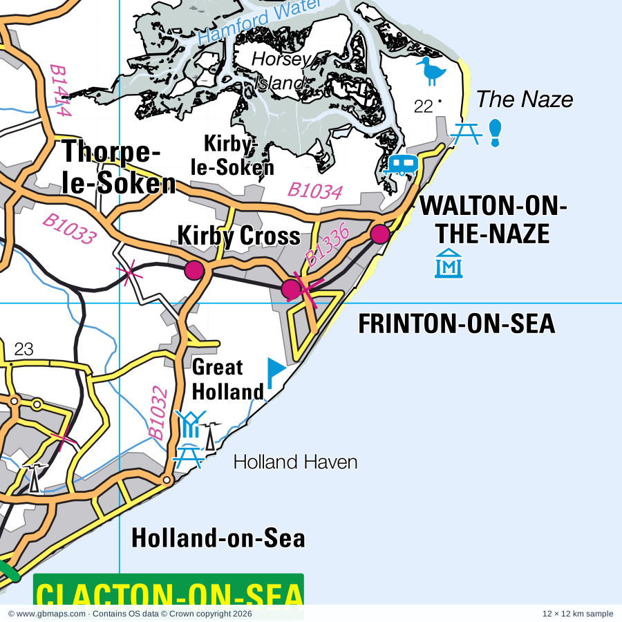
Explore the full 60 × 60 km Frinton-on-Sea regional road map at 1:250,000, covering Frinton-on-Sea, Clacton-on-Sea, Brightlingsea, Harwich, Felixstowe. Compare the complete coverage below; a detailed PDF sample is available free.
River Brett, River Colne, River Stour, Roman River
Landmarks & landscape
Alton Water Reservoir, Barn Farm Solar Farm, Beth Chatto Gardens, Boxted Airfield Museum, Bridge Cottage, Brightlingsea Museum, Colchester, Cudmore Grove Country Park, Dedham Art and Craft Centre, East Bergholt Place Garden, East Essex Aviation Museum, Felixstowe Container Terminal
More named features
Felixstowe Museum, Fingringhoe Wick Nature Reserve, Fingringhoe Wick Visitor Centre, Foulness Island Heritage Centre, Frowick Lane Solar Farm, Giffords Hall, Gnome Magic, High Woods Country Park, Holland Haven Country Park, Knock John Tower, Landguard Fort, Landguard Nature Reserve, Langenhoe Hall Lane Solar Farm, Low Lighthouse Maritime Museum, The Harwich Lifeboat Museum, National Wireless/Television Museum, Mannings Amusement Park, Manningtree Local History Museum, Mersea Museum, Mersea Point Nature Reserve, Mersea Vineyard, Mistley Quay Workshops, Mistley Towers, Natural History Museum, Colchester Castle Museum, Hollytrees Museum, Redoubt Fort & Museum, Rough Tower (Sealand), Shivering Sand Tower, St Botolph's Priory, St John's Abbey Gate, St Peter on the Wall Chapel, St Peter's Flat Nature Reserve, Stour Estuary Nature Reserve, The Munning's Museum & Art Collection, The Naze Nature Reserve, Thorrington Tide Mill, Transmitter Block Radar Museum, Trimley Marshes Nature Reserve, Tumulus, Visitor Centre, Walton Maritime Museum, Wix Lodge Solar Farm, Wrabness Local Nature Reserve
Wholly or partly within the full map rectangle. These boundaries are coverage information, not additional artwork layers.
Babergh DistrictPartly within
Colchester DistrictPartly within
East Suffolk DistrictPartly within
Maldon DistrictPartly within
Rochford DistrictPartly within
Tendring DistrictWholly within
Wards & electoral divisions 61 areas
Alresford & Elmstead Ward
Ardleigh & Little Bromley Ward
Berechurch Ward (part)
Bluehouse Ward
Brantham Ward
Brett Vale Ward (part)
Brightlingsea Ward
Bures St. Mary & Nayland Ward (part)
Burnham-on-Crouch North Ward (part)
Burrsville Ward
Cann Hall Ward
Capel St. Mary Ward
Castle Ward (part)
Copdock & Washbrook Ward (part)
Coppins Ward
Deben Ward (part)
Dovercourt All Saints Ward
Dovercourt Bay Ward
Dovercourt Tollgate Ward
Dovercourt Vines & Parkeston Ward
East Bergholt Ward
Eastcliff Ward
Eastern Felixstowe Ward
Foulness & The Wakerings Ward (part)
Frinton Ward
Ganges Ward
Greenstead Ward
Harwich & Kingsway Ward
Highwoods Ward
Homelands Ward
Kirby Cross Ward
Kirby-le-Soken & Hamford Ward
Lawford, Manningtree & Mistley Ward
Little Clacton Ward
Mersea & Pyefleet Ward (part)
Mile End Ward (part)
New Town & Christ Church Ward (part)
Old Heath & The Hythe Ward
Orwell & Villages Ward (part)
Orwell Ward (part)
Pier Ward
Rural North Ward (part)
Southminster Ward (part)
St. Anne's & St. John's Ward
St. Bartholomew's Ward
St. James Ward
St. John's Ward
St. Osyth Ward
St. Paul's Ward
Stour Valley Ward
Stour Ward
The Bentleys & Frating Ward
The Oakleys & Wix Ward
Thorpe, Beaumont & Great Holland Ward
Tillingham Ward (part)
Tollesbury Ward (part)
Walton Ward
Weeley & Tendring Ward
West Clacton & Jaywick Sands Ward
Western Felixstowe Ward
Wivenhoe Ward
Civil parishes & communities 84 areas
Abberton CP (part)
Alderton CP (part)
Alresford CP
Ardleigh CP
Arwarton CP
Bawdsey CP (part)
Beaumont-cum-Moze CP
Belstead CP (part)
Bentley CP (part)
Boxted CP (part)
Bradfield CP
Bradwell-on-Sea CP (part)
Brantham CP
Brightlingsea CP
Burnham-on-Crouch CP (part)
Capel St. Mary CP
Chelmondiston CP
Copdock and Washbrook CP (part)
Dedham CP
Dengie CP (part)
East Bergholt CP
East Donyland CP
East Mersea CP
Elmstead CP
Falkenham CP (part)
Felixstowe CP
Fingringhoe CP
Foulness CP (part)
Frating CP
Freston CP (part)
Frinton and Walton CP
Great Bentley CP
Great Bromley CP
Great Oakley CP
Great Wakering CP (part)
Harkstead CP
Harwich CP
Higham CP
Holbrook CP
Holton St. Mary CP
Kirton CP (part)
Langenhoe CP
Langham CP
Lawford CP
Layham CP (part)
Levington CP (part)
Little Bentley CP
Little Bromley CP
Little Clacton CP
Little Oakley CP
Manningtree CP
Mistley CP
Myland CP (part)
Nacton CP (part)
Peldon CP (part)
Polstead CP (part)
Ramsey and Parkeston CP
Ramsholt CP (part)
Raydon CP (part)
Shelley CP
Shotley CP
Southminster CP (part)
St. Osyth CP
Stoke-by-Nayland CP (part)
Stratford St. Mary CP
Stratton Hall CP (part)
Stutton CP
Tattingstone CP
Tendring CP
Thorpe-le-Soken CP
Thorrington CP
Tillingham CP (part)
Tollesbury CP (part)
Trimley St. Martin CP
Trimley St. Mary CP
Weeley CP
Wenham Magna CP (part)
Wenham Parva CP (part)
West Mersea CP (part)
Wherstead CP (part)
Wivenhoe CP
Wix CP
Woolverstone CP
Wrabness CP
Source: the GBMaps road atlas, OS Boundary-Line and postcode mapping datasets. Source editions are being checked for publication. Unmarked boundary names are wholly within the sheet; “part” means the map edge crosses the area.
INSIDE YOUR DOWNLOAD
A proper road map, in useful formats
Road classifications, towns and villages, railways, rivers, landscape detail and tourist symbols, brought together in the GBMaps regional road atlas style.
PDF for the finished map. SVG and layered Illustrator artwork for adapting colours, adding your own information and preparing designs.
THE FINISHED SHEET
Designed for print and presentation
Map coverage
60 × 60 km
Sample coverage
12 × 12 km
Print layout
A3 landscape · enlarged 1:250k cartography
Sheet furniture
Border, scale bar, key & north arrow
A few useful details
What changes when I select another square?
Select a surrounding square to bring it into the centre and reveal the maps around it. Each square is a different 60 × 60 km map. The preview, free sample and selected download change together. Neighbouring sheets overlap by 30 km so you can choose the coverage that suits you.
Is the free sample a vector map?
The on-page detail is an SVG. The free download is a separate 12 × 12 km PDF with a link to the full map. Please retain its copyright credits and product link when sharing it.
Can I buy a larger combined map?
These downloads are individual ready-made sheets. Contact GBMaps if you need a larger combined area.