Ely regional road map. Full 60 × 60 km PDF, SVG and Illustrator files, with a free PDF sample.

GBMAPS.COM

Ely Regional Road Map

Call Us Now for Help01751 473136

GREAT BRITAIN ROAD ATLAS · 1:250,000 GB-570-0270

Ely & surrounding area

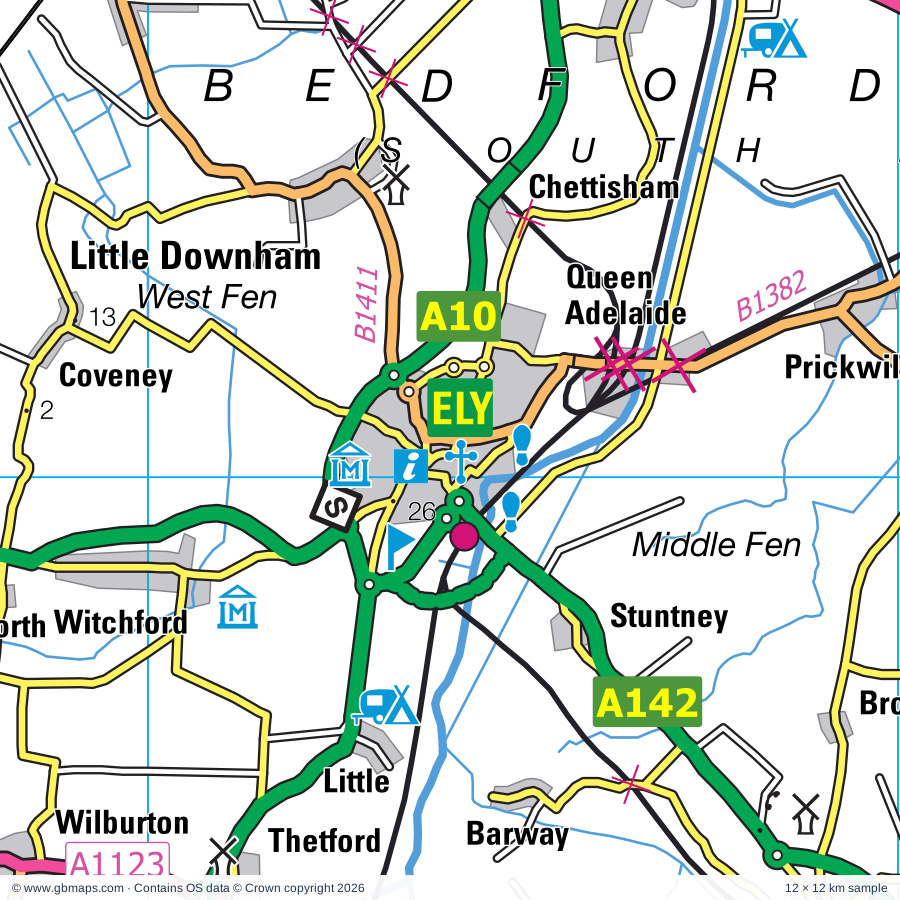
Explore the full 60 × 60 km Ely regional road map at 1:250,000, covering Ely, Cambridge, Mildenhall, Newmarket, Soham. Compare the complete coverage below; a detailed PDF sample is available free.

ELY & SURROUNDING AREAREGIONAL ROAD MAP
60 × 60 km · Full map previewDownload the free SVG ↓

INSIDE THE FULL 60 × 60 KM MAP

Explore the Ely map area

1:250,000 cartography

Towns, villages & places

More mapped places (251)
  • Tuddenham
  • Barton Mills
  • Moulton
  • Cavenham
  • Snailwell
  • Higham
  • Gazeley
  • Fordham
  • Isleham
  • Icklingham
  • Beck Row
  • Landwade
  • Dalham
  • Ashley
  • Eriswell
  • Cheveley
  • Barrow
  • Lackford
  • Exning
  • Burthorpe
  • Denham
  • Risby
  • Kenny Hill
  • Saxon Street
  • Flempton
  • Burwell
  • Upend
  • Woodditton
  • Little Saxham
  • Ousden
  • Lidgate
  • Hargrave
  • Broad Hill
  • Hengrave
  • Kirtling
  • Wicken
  • Lakenheath
  • Wordwell
  • Chevington
  • Westley
  • Culford
  • Dullingham
  • Reach
  • Kirtling Green
  • Wangford
  • Depden
  • Chedburgh
  • Horringer
  • Elveden
  • Wickhambrook
  • Ingham
  • Timworth
  • Cowlinge
  • Upware
  • Prickwillow
  • Barway
  • Clopton Green
  • Stuntney
  • Ampton
  • Brinkley
  • Wickham Street
  • Rede
  • Stradishall
  • Whepstead
  • Carlton
  • Little Bradley
  • Lode
  • Bottisham
  • Denston
  • Nowton
  • Stretham
  • Hawstead
  • Barnham
  • Stansfield
  • Hawkedon
  • Great Thurlow
  • Brockley
  • Troston
  • Chettisham
  • Weeting
  • Chittering
  • Somerton
  • Sicklesmere
  • Clayhithe
  • Feltwell
  • Waterbeach
  • Rushbrooke
  • Barnardiston
  • Blackthorpe
  • Littleport
  • Lawshall
  • Hundon
  • Euston
  • Witchford
  • Horningsea
  • Hartest
  • Thurston
  • Wilburton
  • Withersfield
  • Stanningfield
  • Balsham
  • Sapiston
  • Rougham
  • Little Downham
  • Fulbourn
  • Boxted
  • Poslingford
  • Little Wratting
  • Landbeach
  • Ixworth
  • Teversham
  • Pakenham
  • Kedington
  • Milton
  • Wentworth
  • Croxton
  • Haddenham
  • Coveney
  • Beyton
  • Bardwell
  • Horseheath
  • Shimpling
  • Methwold Hythe
  • Methwold
  • Hessett
  • Cottenham
  • Rushford
  • Stanstead
  • Glemsford
  • Cockfield
  • Aldreth
  • Witcham
  • Cavendish
  • Great Green
  • Stowlangtoft
  • Mundford
  • Sturmer
  • Southery
  • West Tofts
  • Pymoor
  • Cranwich
  • Tostock
  • Alpheton
  • Hildersham
  • Norton
  • Brookville
  • Little Abington
  • Brettenham
  • Impington
  • Linton
  • Stanton
  • Histon
  • Babraham
  • Wixoe
  • Drinkstone
  • Ickburgh
  • Sutton
  • Bartlow
  • Bridge Street
  • Northwold
  • Rampton
  • Pentlow
  • Hunston
  • Barningham
  • Langham
  • Felsham
  • Gedding
  • Mepal
  • Ashen
  • Upthorpe
  • Woolpit
  • Westwick
  • Ovington
  • Ten Mile Bank
  • Hadstock
  • Foxearth
  • Girton
  • Birdbrook
  • Badwell Ash
  • Hepworth
  • Stapleford
  • Whittington
  • Ridgewell
  • Hilgay
  • Manea
  • Liston
  • Oakington
  • Great Shelford
  • Elmswell
  • Willingham
  • Sawston
  • Gasthorpe
  • Foulden
  • East Wretham
  • Rattlesden
  • Lavenham
  • Pampisford
  • Stoke Ferry
  • Welney
  • Wretton
  • Ashdon
  • Hopton
  • Bridgham
  • Borley
  • Grantchester
  • Stonebridge
  • Fordham
  • Brettenham
  • Coton
  • Whittlesford
  • Illington
  • Hauxton
  • Bodney
  • Hinxton
  • Lakes End
  • Horseway
  • Duxford
  • Barton
  • Bulmer
  • Kettlebaston
  • Ickleton
  • Little Chesterford
  • Newton
  • Harston
  • Christchurch
  • Hitcham
  • Larling
  • Upsher Green
  • Haslingfield
  • Milden
  • Thompson
  • Thriplow
  • Merton
  • Breckles
  • Bildeston
  • Chelsworth
  • Wimblington
  • Snetterton
  • Foxton
  • Newton
  • Shropham
  • Edwardstone
  • Fowlmere
  • Lindsey
  • Caston
  • Griston
  • Northacre
  • Semer
  • Groton
  • Boxford
  • Heydon

Roads across this sheet

M11, A10, A11, A14, A131, A134, A141, A142, A143, A505, A603, A604, A1017, A1065, A1066, A1071, A1075, A1088, A1092, A1101, A1123, A1134, A1141, A1301

More road numbers

A1302, A1303, A1304, A1307, A1309, A1421, B184, B1046, B1047, B1049, B1050, B1052, B1054, B1057, B1058, B1061, B1063, B1064, B1065, B1066, B1071, B1077, B1078, B1085, B1093, B1094, B1098, B1099, B1100, B1101, B1102, B1103, B1104, B1106, B1107, B1108, B1111, B1112, B1115, B1160, B1368, B1381, B1382, B1383, B1386, B1411, B1506, B1508

Rivers & waterways

Canal, Counter Drain, Forty Foot or Vermuden's Drain, Little Ouse River, New Bedford River or Hundred Foot Drain, New River, Old Bedford River, Old Croft R, Old Croft River, River Brett, River Cam, River Cam or Granta

More waterways

River Cam or Rhee, River Colne, River Delph, River Granta, River Great Ouse, River Kennett, River Lark, River Nene ( old course ), River Nene (old course), River Stour, River Thet, River Wissey, Sixteen Foot Drain, Twenty Foot River, White Mill Drain

Landmarks & landscape

Abington Pottery, Ampton Point to Point Racecourse, Ancient House Museum, Charles Burrell Museum, Anglesey Abbey, Anglesey Abbey and Gardens, Apes Hall, Ashdon Village Museum, Bardwell Windmill, Black Peak Solar Farm, Bradfield Woods Nature Reserve, Brandon Country Park, Brandon Country Visitor Centre

More named features

Brandon Heritage Museum, Burwell Solar Farm, Bury St Edmunds Abbey, Cambridge Corn Exchange, Kids Kingdom and Laser Quest, Cambridge Contemporary Art, Cambridge University Botanic Gardens, Cambridge and County Folk Museum, Museums of Classical Archaeology, Zoology and Science, Scott Polar Institute, Aerial Photography, Archaeology and Anthropology, Cavenham Heath Nature Reserve, Chilford Hall Vineyard, Chittering Solar Farm, Church of the Holy Sepulchre, Clare Ancient House Museum, Clare Castle Country Park, Clare Priory (Rems of), Clare Priory (remains of), Cottenham Point to Point Racecourse, Denham Castle, Denny Abbey, Desert Rats Memorial, Devil's Dyke Nature Reserve, Devils Dyke (Ditch Farm) Nature Reserve, Duxford Chapel, Duxford Imperial War Museum, East Town Park Country Park & Visitor Centre, East Wretham Heath Nature Reserve, Ely Cathedral, Ely Museum, Stained Glass Museum, Euston Hall, Euston Watermill, Farmland Museum, Fitzwilliam Museum, Sedgewick Museum Of Earth Sciences, Whipple Museum of the History of Science, Fleam Dyke Nature Reserve, Fordham Abbey, Fort, Fowlmere Nature Reserve, Gainsborough's House, Gifford's Hall Vineyard and Sweet Pea Centre, Go Ape Thetford, Grimes Graves Flint Mines, Grimes Graves Flint Mines & Visitor centre, Groton Wood Nature Reserve, Hall Farm, High Lodge Forest Centre, Go Ape Thetford, Hinxton Watermill, Horseheath Point to Point Racecourse, Iceni Brewery, Ickworth House, Isleham Priory Church, Kentwell Hall, Kilverstone Hall, Knettishall Heath Country Park, Lackford Wildfowl Nature Reserve, Lark Hall, Lavenham The Guildhall of Corpus Christi, Lavenham Walk Nature Reserve, Limekiln Close Nature Reserve, Linton Zoological Gardens, Lode Mill, Lynford Arboretum, March Museum, Maze, Meadow Farm Solar Farm, Melford Hall, Mildenhall Stadium Motor Racing Circuit, Mildenhall and District Museum, Milton Country Park, Mingay Park Solar Farm, Moulton Packhorse Bridge, Museum, Museum of Technology, Museum of Archaeology, Museum of Archaeology & Anthropology, Science Centre, National Horse Racing Museum, National Stud, Newmarket Racecourses, Nowton Country Park, Ouse Washes Nature Reserve, Ouse Washes Visitor Centre, Pakenham Water Mill, Prickwillow Drainage Engine Museum, Priory, RAF Witchford Display, Reaches Farm Solar Farm, Rougham Control Tower Museum, Rupert Brooke Museum, Sascombe Vineyard, Solar Farm, St Georges Distillery, St James Chapel, Stanton Post Mill, Stowbridge Solar Park, Suffolk Regimental Museum, Moyse's Hall Museum, The Malthouse Project, The John MacDougal Visitor Centre, The Priory, The Little Hall, Theatre Royal, Greene King Brewery, Thetford Church of the Holy Sepulchre, Thetford Priory, Thetford Warren Lodge, Trumpington Meadows Country Park, Tumuli, Visitor Centre, Wandlebury Country Park, Waterbeach Station Museum, Weeting Castle, Weeting Heath Nature Reserve, Welney Wetland Centre Visitor Centre, Welney Wildfowl Refuge, West Stow Anglo-Saxon Village, Lackford Lakes Visitor Centre, West Stow Country Park, Wicken Fen Nature Reserve, Wicken Fen Visitor Centre, Wildtracks, Woolpit & District Museum, Wort's Causeway Nature Reserve, Wyken Hall, Wyken Vineyard
Local authority & parish coverage

Wholly or partly within the full map rectangle. These boundaries are coverage information, not additional artwork layers.

  • Babergh DistrictPartly within
  • Braintree DistrictPartly within
  • Breckland DistrictPartly within
  • Cambridge DistrictWholly within
  • East Cambridgeshire DistrictPartly within
  • Fenland DistrictPartly within
  • King's Lynn and West Norfolk DistrictPartly within
  • Mid Suffolk DistrictPartly within
  • North Hertfordshire DistrictPartly within
  • South Cambridgeshire DistrictPartly within
  • Uttlesford DistrictPartly within
  • West Suffolk DistrictPartly within
Wards & electoral divisions 142 areas
  • Abbey Ward
  • Abbeygate Ward
  • All Saints & Wayland Ward (part)
  • Arbury Ward
  • Ashdon Ward (part)
  • Ashill Ward (part)
  • Assington Ward (part)
  • Balsham Ward
  • Bardwell Ward
  • Barningham Ward (part)
  • Barrington Ward (part)
  • Barrow Ward
  • Bedingfeld Ward (part)
  • Bottisham Ward
  • Box Vale Ward (part)
  • Brandon Central Ward
  • Brandon East Ward
  • Brandon West Ward
  • Brett Vale Ward (part)
  • Bumpstead Ward (part)
  • Burwell Ward
  • Castle Ward
  • Chadacre Ward
  • Chatteris North & Manea Ward (part)
  • Chatteris South Ward (part)
  • Chedburgh & Chevington Ward
  • Cherry Hinton Ward
  • Clare, Hundon & Kedington Ward
  • Coleridge Ward
  • Cottenham Ward
  • Denver Ward (part)
  • Doddington & Wimblington Ward (part)
  • Downham Villages Ward
  • Duxford Ward
  • East Chesterton Ward
  • Eastgate Ward
  • Elm & Christchurch Ward (part)
  • Elmswell & Woolpit Ward (part)
  • Ely East Ward
  • Ely North Ward
  • Ely West Ward
  • Ermine Ward (part)
  • Exning Ward
  • Feltwell Ward
  • Fen Ditton & Fulbourn Ward
  • Fordham & Isleham Ward
  • Forest Ward
  • Foxton Ward (part)
  • Girton Ward (part)
  • Great Cornard Ward (part)
  • Guiltcross Ward (part)
  • Haddenham Ward (part)
  • Hadleigh North Ward (part)
  • Harling & Heathlands Ward (part)
  • Harston & Comberton Ward (part)
  • Haughley, Stowupland & Wetherden Ward (part)
  • Haverhill Central Ward
  • Haverhill East Ward
  • Haverhill North Ward
  • Haverhill South East Ward
  • Haverhill South Ward
  • Haverhill West Ward
  • Histon & Impington Ward
  • Horringer Ward
  • Iceni Ward
  • Ixworth Ward
  • Kentford & Moulton Ward
  • King's Hedges Ward
  • Lakenheath Ward
  • Lavenham Ward
  • Linton Ward
  • Littlebury, Chesterford & Wenden Lofts Ward (part)
  • Littleport Ward
  • Long Melford Ward
  • Longstanton Ward (part)
  • Manor Ward
  • March East Ward
  • March North Ward (part)
  • March South Ward
  • March West & Benwick Ward (part)
  • Market Ward
  • Melbourn Ward (part)
  • Methwold Ward
  • Mildenhall Great Heath Ward
  • Mildenhall Kingsway & Market Ward
  • Mildenhall Queensway Ward
  • Milton & Waterbeach Ward
  • Minden Ward
  • Moreton Hall Ward
  • Newmarket East Ward
  • Newmarket North Ward
  • Newmarket West Ward
  • Newnham Ward
  • North West Cosford Ward (part)
  • Onehouse Ward (part)
  • Over & Willingham Ward (part)
  • Pakenham & Troston Ward
  • Petersfield Ward
  • Queen Edith's Ward
  • Rattlesden Ward (part)
  • Risby Ward
  • Romsey Ward
  • Rougham Ward
  • Saffron Walden Castle Ward (part)
  • Saham Toney Ward (part)
  • Sawston Ward
  • Shelford Ward
  • Soham North Ward
  • Soham South Ward
  • South East Cosford Ward (part)
  • Southgate Ward
  • St. Olaves Ward
  • Stanton Ward
  • Stour Valley North Ward (part)
  • Stour Valley South Ward (part)
  • Stretham Ward
  • Sudbury North East Ward
  • Sudbury North West Ward
  • Sudbury South East Ward
  • Sudbury South West Ward
  • Sutton Ward (part)
  • The Fornhams & Great Barton Ward
  • The Rows Ward
  • The Sampfords Ward (part)
  • Thetford Boudica Ward
  • Thetford Burrell Ward
  • Thetford Castle Ward
  • Thetford Priory Ward
  • Thurston Ward
  • Tollgate Ward
  • Trumpington Ward
  • Upwell & Delph Ward (part)
  • Walsham-le-Willows Ward (part)
  • Watton Ward (part)
  • West Chesterton Ward
  • Westgate Ward
  • Whepstead & Wickhambrook Ward
  • Whittlesford Ward
  • Wissey Ward (part)
  • Withersfield Ward
  • Woodditton Ward
  • Yeldham Ward (part)
Civil parishes & communities 354 areas
  • Acton CP
  • Alpheton CP
  • Ampton CP
  • Ashdon CP (part)
  • Ashen CP
  • Ashley CP
  • Assington CP (part)
  • Babraham CP
  • Badwell Ash CP (part)
  • Balsham CP
  • Bardwell CP
  • Barley CP (part)
  • Barnardiston CP
  • Barnham CP
  • Barningham CP
  • Barrington CP (part)
  • Barrow CP
  • Bartlow CP
  • Barton CP (part)
  • Barton Mills CP
  • Beck Row, Holywell Row and Kenny Hill CP
  • Belchamp Otten CP (part)
  • Belchamp St. Paul CP
  • Belchamp Walter CP (part)
  • Beyton CP
  • Bildeston CP (part)
  • Birdbrook CP (part)
  • Borley CP
  • Bottisham CP
  • Boxford CP (part)
  • Boxted CP
  • Bradfield Combust with Stanningfield CP
  • Bradfield St. Clare CP
  • Bradfield St. George CP
  • Brandon CP
  • Brent Eleigh CP
  • Brettenham CP
  • Brettenham CP
  • Bridgham CP
  • Brinkley CP
  • Brockley CP
  • Bulmer CP (part)
  • Burrough Green CP
  • Burwell CP
  • Bury St. Edmunds CP
  • Buxhall CP (part)
  • Carbrooke CP (part)
  • Carlton CP
  • Castle Camps CP
  • Caston CP
  • Cavendish CP
  • Cavenham CP
  • Chatteris CP (part)
  • Chedburgh CP
  • Chelsworth CP
  • Cheveley CP
  • Chevington CP
  • Chilton CP
  • Chippenham CP
  • Chrishall CP (part)
  • Christchurch CP (part)
  • Clare CP
  • Cockfield CP
  • Coney Weston CP
  • Coton CP
  • Cottenham CP
  • Coveney CP
  • Cowlinge CP
  • Cranwich CP
  • Croxton CP
  • Culford CP
  • Dalham CP
  • Denham CP
  • Denston CP
  • Denver CP (part)
  • Depden CP
  • Didlington CP
  • Doddington CP (part)
  • Downham CP
  • Drinkstone CP
  • Dry Drayton CP (part)
  • Dullingham CP
  • Duxford CP
  • Edwardstone CP
  • Elm CP (part)
  • Elmdon CP (part)
  • Elmswell CP (part)
  • Elveden CP
  • Ely CP
  • Eriswell CP
  • Euston CP
  • Exning CP
  • Fakenham Magna CP
  • Felsham CP
  • Feltwell CP
  • Fen Ditton CP
  • Flempton CP
  • Fordham CP
  • Fordham CP (part)
  • Fornham All Saints CP
  • Fornham St. Genevieve CP
  • Fornham St. Martin CP
  • Foulden CP (part)
  • Fowlmere CP
  • Foxearth CP
  • Foxton CP (part)
  • Freckenham CP
  • Fulbourn CP
  • Garboldisham CP (part)
  • Gazeley CP
  • Gedding CP
  • Girton CP (part)
  • Glemsford CP
  • Grantchester CP
  • Great Abington CP
  • Great Ashfield CP (part)
  • Great Barton CP
  • Great Bradley CP
  • Great Chesterford CP
  • Great Cornard CP (part)
  • Great Cressingham CP (part)
  • Great Finborough CP (part)
  • Great Livermere CP
  • Great Shelford CP
  • Great Thurlow CP
  • Great Waldingfield CP
  • Great Whelnetham CP
  • Great Wilbraham CP
  • Great Wratting CP
  • Great and Little Chishill CP (part)
  • Griston CP (part)
  • Groton CP
  • Haddenham CP (part)
  • Hadleigh CP (part)
  • Hadstock CP
  • Hargrave CP
  • Harling CP (part)
  • Harston CP
  • Hartest CP
  • Haslingfield CP (part)
  • Hauxton CP
  • Haverhill CP
  • Hawkedon CP
  • Hawstead CP
  • Helions Bumpstead CP (part)
  • Hempstead CP (part)
  • Hengrave CP
  • Hepworth CP
  • Herringswell CP
  • Hessett CP
  • Heydon CP (part)
  • Higham CP
  • Hilborough CP (part)
  • Hildersham CP
  • Hilgay CP
  • Hinxton CP
  • Histon CP
  • Hitcham CP (part)
  • Hockham CP
  • Hockwold cum Wilton CP
  • Honington CP
  • Hopton CP (part)
  • Horningsea CP
  • Horringer CP
  • Horseheath CP
  • Hundon CP
  • Hunston CP
  • Ickburgh CP
  • Ickleton CP
  • Icklingham CP
  • Ickworth CP
  • Impington CP
  • Ingham CP
  • Isleham CP
  • Ixworth CP
  • Ixworth Thorpe CP
  • Kedington CP
  • Kennett CP
  • Kentford CP
  • Kersey CP (part)
  • Kettlebaston CP
  • Kilverstone CP
  • Kirtling CP
  • Knettishall CP
  • Lackford CP
  • Lakenheath CP
  • Landbeach CP
  • Langham CP
  • Lavenham CP
  • Lawshall CP
  • Layham CP (part)
  • Lidgate CP
  • Lindsey CP
  • Linton CP
  • Liston CP
  • Little Abington CP
  • Little Bradley CP
  • Little Chesterford CP
  • Little Cressingham CP (part)
  • Little Ellingham CP (part)
  • Little Livermere CP
  • Little Shelford CP
  • Little Thurlow CP
  • Little Waldingfield CP
  • Little Whelnetham CP
  • Little Wilbraham CP
  • Little Wratting CP
  • Little Yeldham CP (part)
  • Littlebury CP (part)
  • Littleport CP
  • Lode CP
  • Long Melford CP
  • Longstanton CP (part)
  • Lynford CP
  • Madingley CP (part)
  • Manea CP (part)
  • March CP (part)
  • Market Weston CP
  • Melbourn CP (part)
  • Mepal CP
  • Merton CP (part)
  • Methwold CP
  • Middleton CP (part)
  • Milden CP
  • Mildenhall High CP
  • Milton CP (DET)
  • Monks Eleigh CP
  • Moulton CP
  • Mundford CP
  • Nedging-with-Naughton CP (part)
  • Newmarket CP
  • Newton CP (part)
  • Newton CP
  • Nordelph CP (part)
  • Northstowe CP (part)
  • Northwold CP
  • Norton CP
  • Nowton CP
  • Oakington and Westwick CP (part)
  • Orchard Park CP
  • Ousden CP
  • Ovington CP
  • Oxborough CP (part)
  • Pakenham CP
  • Pampisford CP
  • Pentlow CP
  • Polstead CP (part)
  • Poslingford CP
  • Preston St. Mary CP
  • Quidenham CP (part)
  • Radwinter CP (part)
  • Rampton CP
  • Rattlesden CP (part)
  • Reach CP
  • Red Lodge CP
  • Rede CP
  • Riddlesworth CP
  • Ridgewell CP (part)
  • Risby CP
  • Rocklands CP (part)
  • Roudham and Larling CP
  • Rushbrooke with Rougham CP
  • Ryston CP (part)
  • Saffron Walden CP (part)
  • Santon Downham CP
  • Sapiston CP
  • Sawston CP
  • Scoulton CP (part)
  • Semer CP (part)
  • Sewards End CP (part)
  • Shelland CP (part)
  • Shepreth CP (part)
  • Shimpling CP
  • Shropham CP (part)
  • Shudy Camps CP
  • Snailwell CP
  • Snetterton CP (part)
  • Soham CP
  • Somerton CP
  • South Trumpington CP
  • Southery CP
  • Stambourne CP (part)
  • Stanford CP
  • Stansfield CP
  • Stanstead CP
  • Stanton CP
  • Stapleford CP
  • Steeple Bumpstead CP (part)
  • Stetchworth CP
  • Stoke Ferry CP (part)
  • Stoke-by-Clare CP
  • Stow Bedon and Breckles CP
  • Stow cum Quy CP
  • Stowlangtoft CP
  • Stradishall CP
  • Strethall CP (part)
  • Stretham CP
  • Sturmer CP
  • Sturston CP
  • Sudbury CP
  • Sutton CP (part)
  • Swaffham Bulbeck CP
  • Swaffham Prior CP
  • Teversham CP
  • The Saxhams CP
  • Thelnetham CP (part)
  • Thetford CP
  • Thetford CP
  • Thompson CP
  • Thorpe Morieux CP
  • Thriplow and Heathfield CP
  • Thurston CP
  • Tilbury Juxta Clare CP (part)
  • Timworth CP
  • Tostock CP
  • Tottington CP
  • Troston CP
  • Tuddenham CP
  • Upwell CP (part)
  • Walsham-le-Willows CP (part)
  • Waterbeach CP
  • Wattisfield CP (part)
  • Wattisham CP (part)
  • Watton CP (part)
  • Weeting-with-Broomhill CP
  • Welney CP
  • Wentworth CP
  • Wereham CP (part)
  • West Dereham CP (part)
  • West Row CP
  • West Stow CP
  • West Wickham CP
  • West Wratting CP
  • Westley CP
  • Westley Waterless CP
  • Weston Colville CP
  • Wetherden CP (part)
  • Whepstead CP
  • Whittlesford CP
  • Wicken CP
  • Wickhambrook CP
  • Wilburton CP
  • Willingham CP (part)
  • Wimblington CP (part)
  • Witcham CP
  • Witchford CP
  • Withersfield CP
  • Wixoe CP
  • Woodditton CP
  • Woolpit CP (part)
  • Wordwell CP
  • Worlington CP
  • Wretham CP
  • Wretton CP (part)

Source: the GBMaps road atlas, OS Boundary-Line and postcode mapping datasets. Source editions are being checked for publication. Unmarked boundary names are wholly within the sheet; “part” means the map edge crosses the area.

Place lists are selected from the map source, not a complete gazetteer. Named features describe the cartography; visitor facilities and opening status are not verified. The free sample covers only 12 × 12 km of this larger sheet.

INSIDE YOUR DOWNLOAD

A proper road map, in useful formats

Road classifications, towns and villages, railways, rivers, landscape detail and tourist symbols, brought together in the GBMaps regional road atlas style.

PDF filePDFSVG fileSVGAdobe Illustrator AI fileAi

PDF for the finished map. SVG and layered Illustrator artwork for adapting colours, adding your own information and preparing designs.

THE FINISHED SHEET

Designed for print and presentation

Map coverage
60 × 60 km
Sample coverage
12 × 12 km
Print layout
A3 landscape · enlarged 1:250k cartography
Sheet furniture
Border, scale bar, key & north arrow

A few useful details

What changes when I select another square?

Select a surrounding square to bring it into the centre and reveal the maps around it. Each square is a different 60 × 60 km map. The preview, free sample and selected download change together. Neighbouring sheets overlap by 30 km so you can choose the coverage that suits you.

Is the free sample a vector map?

The on-page detail is an SVG. The free download is a separate 12 × 12 km PDF with a link to the full map. Please retain its copyright credits and product link when sharing it.

Can I buy a larger combined map?

These downloads are individual ready-made sheets. Contact GBMaps if you need a larger combined area.

FREE PDF SAMPLE

Your free map sample

Your free 12 × 12 km sample includes a link back to this map, so you can return for the full area whenever you need it.

Download free PDF sample ↓

Get your Ely map

Map download bundle

£24.00including VATOne payment

Pay securely

One payment. Your map stays open.

Your map download

Your map files

Preparing your download…

Checking your private download link…

Your map downloads

Already bought a map?

Find the downloads from your purchases.

Enter the email address you used at checkout. We’ll email you a private link to your available map downloads.