Edinburgh regional road map. Full 60 × 60 km PDF, SVG and Illustrator files, with a free PDF sample.

GBMAPS.COM

Edinburgh Regional Road Map

Call Us Now for Help01751 473136

GREAT BRITAIN ROAD ATLAS · 1:250,000 GB-330-0660

Edinburgh & surrounding area

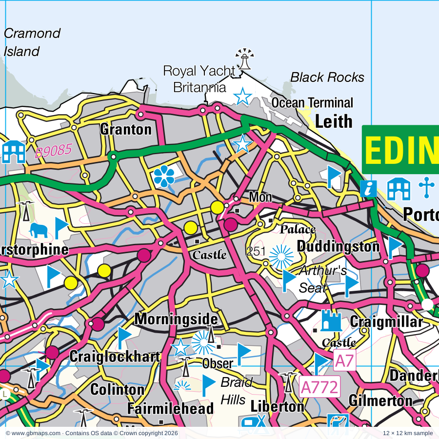
Explore the full 60 × 60 km Edinburgh regional road map at 1:250,000, covering Dunfermline, Bonnyrigg, Loanhead, Penicuik, Musselburgh. Compare the complete coverage below; a detailed PDF sample is available free.

EDINBURGH & SURROUNDING AREAREGIONAL ROAD MAP
60 × 60 km · Full map previewDownload the free SVG ↓

INSIDE THE FULL 60 × 60 KM MAP

Explore the Edinburgh map area

1:250,000 cartography

Towns, villages & places

More mapped places (139)

Roads across this sheet

M8, M9, M90, A1, A7, A8, A68, A70, A71, A72, A89, A90, A198, A199, A697, A699, A700, A701, A702, A703, A704, A705, A707, A708

More road numbers

A720, A721, A766, A768, A772, A779, A803, A823, A823(M), A899, A900, A901, A902, A903, A904, A907, A909, A921, A993, A994, A1140, A6089, A6093, A6094, A6095, A6105, A6106, A6124, A6137, B700, B701, B702, B703, B704, B709, B710, B712, B792, B800, B900, B901, B903, B907, B912, B913, B916, B923, B924, B925, B980, B981, B1343, B1345, B1346, B1347, B1348, B1349, B1350, B1361, B1377, B1407, B6340, B6355, B6356, B6359, B6360, B6361, B6362, B6363, B6367, B6368, B6369, B6370, B6371, B6372, B6374, B6392, B6394, B6397, B6398, B6404, B6414, B6415, B6454, B6457, B6458, B6471, B6482, B7003, B7006, B7007, B7008, B7015, B7016, B7026, B7030, B7031, B7059, B7060, B7062, B8020, B8046, B9037, B9080, B9085, B9109, B9155, B9156, B9157

Rivers & waterways

Birns Water, Caddon Water, Colstoun Water, Culter Water, Dye Water, Eddleston Water, Ettrick Water, Faseny Water, Gala Water, Gifford Water, Glensax Burn, Holms Water

More waterways

Hopes Water, Leader Water, Leithen Water, Linhouse Water, Lugate Water, Lyne Water, Manor Water, North Medwin, Peffer Burn, River Almond, River Clyde, River Esk, River North Esk, River South Esk, River Tweed, River Tyne, Soonhope Burn, South Medwin, Tyne Water, Union Canal, Water of Leith, Yarrow Water

Landmarks & landscape

AD Pottery, Abbotsford, Aberdour Castle, Aberlady Bay Nature Reserve, Almond Valley Heritage Centre, Almondell and Calder Wood Country Park, Arniston House, Barnbougle Castle, Bavelaw Castle, Bavelaw Marsh Nature Reserve, Beecraigs Country Park, Beltane Studios

More named features

Bemersyde Gardens, Biggar Gasworks Museum, Greenhill Covenanters House, Museum of Biggar & Upper Clydesdale, Blackness Castle, Bonaly Country Park, Bore Stane, Broch, Burntisland Museum, Museum of Communications, Caiy Stone, Calton Hill, Cammo Park, Cardrona Cycle Trails, Castle, Castlelaw, Chapel, Coastal Communities Museum, Corstorphine Dovecote, Coulter Motte Hill, Craigencalt Farm Ecology Centre, Craigmillar Castle, Crichton Castle, Cross Kirk - Peebles, Cycle Trail, Dalhousie Castle, Dalkeith Country Park, Dalmeny House, Dawyck Botanic Garden, Dawyck House, Deep Sea World, Deer Park, Dirleton Castle, Dirleton Gallery, Dirleton Garden, Douglas Davies Gallery, Drochil Castle, Dryburgh Abbey, Dun Law, Dunfermline Abbey, Dunfermline Palace, Eagle Rock, Edinburgh Bird of Prey Centre, Edinburgh Butterfly & Insect World, Edinburgh Canal Centre, Edinburgh Castle, Edinburgh Zoo, Eildontree Stone, Ellbank & Traquair Forest Cycle Trails, Five Sisters Zoo Park, Flotterstone Information Centre, Fordell Castle, Forth Bridge (World Heritage Site), Gladstone's Land, The Georgian House, Glen House, Glenkinchie Distillery, Gosford House, Hailes Castle, Hare Faulds, Harlow House Visitor Centre, Harmony Garden, Hawthornden Castle, Heriot Watt University Museum, Hermitage of Braid, Hillend Country Park, Hopetoun House, Hotel, House of The Binns, Inveresk Lodge Garden, Inwood Garden, John Buchan Centre, Jupiter Artland, Kailzie, Lauriston Castle, Leith Mills, Leith Waterworld, Lennoxlove House, Levenhall Links Leisure Park, Lindean Mill Glass, Linlithgow Canal Museum, The Linlithgow Story, Linlithgow Palace, Livingston Mill, Malleny House, Malleny House Gardens, Melrose Abbey, Mill, Museum of Childhood, The Museum of Edinburgh, Dynamic Earth, The Peoples Story, John Knox House, Museum of Scotland, Museum of Fire, Regimental Museum, of The Royal Scots Dragoon Guards, National War Museum of Scotland, Writers' Museum, Musselburgh Racecourse, Myreton Motor Museum, National Flag Heritage Centre, National Museum of Flight, National Scout Activity Centre, Nature Reserve, Neidpath Castle, Newhailes House, Nunraw Abbey, Old & New Towns Edinburgh (World Heritage Site), Old Gala House, Ormiston Cross, Palace of Holyroodhouse, Pentland Hills Regional Park, Pittencraft Park, Fire Station Creative, Pittencrieff House Museum, Andrew Carnegie Birthplace Museum, Dunfermline Museum, Abbot House, Posso Settlement (rems of), Potter Around, Preston Grange Industrial Heritage Museum, Preston Mill, Preston Tower, Preston Market Cross, Priorwood Garden, Queensferry Museum, ROMAN FORT, ROMAN FORTLET, Ratho Adventure Centre, Robert Smail's Printing Works, Roslin Glen Country Park, Royal Botanic Garden, Royal Highland Showground, Royal Highland Centre, Royal Observatory, Royal Scottish Academy, City Arts Centre, Talbot Rice Gallery, The Hub, The Edinburgh Dungeon, Royal Yacht Britannia, Scottish Archery Centre, Scottish Mining Museum, Scottish National Gallery of Modern Art, Dean Gallery, Scottish National Portrait Gallery, National Gallery of Scotland, Our Dynamic Earth, Scottish Railway Museum, Bo'ness Motor Museum, Scottish Seabird Centre, Seton Collegiate Church (Chapel), Seton House, Chapel, Soutra Aisle, St Bridget's Kirk (rems), St Colm's Abbey (Inchcolm), St Martin's Church - ruins, St Mary's Church, St Mary's Cathedral, St Gile's Cathedral, St Mary's Pleasance and Lady Kitty's Garden, St Ronan's Wells Centre, Cashmere Country, St Triduana's Chapel, Stobo Castle, TRIMONTIVM, Tantallon Castle, Tapitlaw Farm Pony Trekking, The Chesters, The Linlithgow Canal Centre, The Scottish Borders Donkey Sanctuary, The Tron, Surgeons Hall Museum, Royal Scots Regimental Museum, Dolls Museum, Thirlestane Castle, Tinnis Castle, Torry Bay Nature Reserve, Tower, Townhill Country Park, Traquair House, Tweed Valley Forest Park Visitor Centre, Tweeddale Museum and Art Gallery, The Cornice Museum, Visitor Centre, Visitor Centre & Activity Centre, Vogrie Country Park, Wallace Statue, Westmuir Riding Centre, Whitmuir The Organic Place Farm, Winton House, Yester Castle, Yester House
Local authority & parish coverage

Wholly or partly within the full map rectangle. These boundaries are coverage information, not additional artwork layers.

  • City of EdinburghWholly within
  • East LothianPartly within
  • FalkirkPartly within
  • FifePartly within
  • MidlothianWholly within
  • Scottish BordersPartly within
  • South LanarkshirePartly within
  • West LothianPartly within
Wards & electoral divisions 55 areas
  • Almond Ward
  • Bathgate Ward (part)
  • Bo'ness and Blackness Ward (part)
  • Bonnyrigg Ward
  • Broxburn, Uphall and Winchburgh Ward
  • Burntisland, Kinghorn and Western Kirkcaldy Ward (part)
  • City Centre Ward
  • Clydesdale East Ward (part)
  • Clydesdale North Ward (part)
  • Colinton/Fairmilehead Ward
  • Corstorphine/Murrayfield Ward
  • Cowdenbeath Ward (part)
  • Craigentinny/Duddingston Ward
  • Dalkeith Ward
  • Drum Brae/Gyle Ward
  • Dunbar and East Linton Ward (part)
  • Dunfermline Central Ward
  • Dunfermline North Ward (part)
  • Dunfermline South Ward
  • East Livingston and East Calder Ward
  • Fauldhouse and the Breich Valley Ward (part)
  • Forth Ward
  • Fountainbridge/Craiglockhart Ward
  • Galashiels and District Ward
  • Haddington and Lammermuir Ward (part)
  • Inverkeithing and Dalgety Bay Ward
  • Inverleith Ward
  • Jedburgh and District Ward (part)
  • Leaderdale and Melrose Ward (part)
  • Leith Walk Ward
  • Leith Ward
  • Liberton/Gilmerton Ward
  • Linlithgow Ward (part)
  • Livingston North Ward
  • Livingston South Ward
  • Mid Berwickshire Ward (part)
  • Midlothian East Ward
  • Midlothian South Ward
  • Midlothian West Ward
  • Morningside Ward
  • Musselburgh Ward
  • North Berwick Coastal Ward (part)
  • Penicuik Ward
  • Pentland Hills Ward
  • Portobello/Craigmillar Ward
  • Preston, Seton and Gosford Ward
  • Rosyth Ward
  • Selkirkshire Ward (part)
  • Sighthill/Gorgie Ward
  • Southside/Newington Ward
  • Tranent, Wallyford and Macmerry Ward
  • Tweeddale East Ward (part)
  • Tweeddale West Ward (part)
  • West Fife and Coastal Villages Ward (part)
  • Whitburn and Blackburn Ward (part)
Civil parishes & communities 0 areas

    Source: the GBMaps road atlas, OS Boundary-Line and postcode mapping datasets. Source editions are being checked for publication. Unmarked boundary names are wholly within the sheet; “part” means the map edge crosses the area.

    Place lists are selected from the map source, not a complete gazetteer. Named features describe the cartography; visitor facilities and opening status are not verified. The free sample covers only 12 × 12 km of this larger sheet.

    INSIDE YOUR DOWNLOAD

    A proper road map, in useful formats

    Road classifications, towns and villages, railways, rivers, landscape detail and tourist symbols, brought together in the GBMaps regional road atlas style.

    PDF filePDFSVG fileSVGAdobe Illustrator AI fileAi

    PDF for the finished map. SVG and layered Illustrator artwork for adapting colours, adding your own information and preparing designs.

    THE FINISHED SHEET

    Designed for print and presentation

    Map coverage
    60 × 60 km
    Sample coverage
    12 × 12 km
    Print layout
    A3 landscape · enlarged 1:250k cartography
    Sheet furniture
    Border, scale bar, key & north arrow

    A few useful details

    What changes when I select another square?

    Select a surrounding square to bring it into the centre and reveal the maps around it. Each square is a different 60 × 60 km map. The preview, free sample and selected download change together. Neighbouring sheets overlap by 30 km so you can choose the coverage that suits you.

    Is the free sample a vector map?

    The on-page detail is an SVG. The free download is a separate 12 × 12 km PDF with a link to the full map. Please retain its copyright credits and product link when sharing it.

    Can I buy a larger combined map?

    These downloads are individual ready-made sheets. Contact GBMaps if you need a larger combined area.

    FREE PDF SAMPLE

    Your free map sample

    Your free 12 × 12 km sample includes a link back to this map, so you can return for the full area whenever you need it.

    Download free PDF sample ↓

    Get your Edinburgh map

    Map download bundle

    £24.00including VATOne payment

    Pay securely

    One payment. Your map stays open.

    Your map download

    Your map files

    Preparing your download…

    Checking your private download link…

    Your map downloads

    Already bought a map?

    Find the downloads from your purchases.

    Enter the email address you used at checkout. We’ll email you a private link to your available map downloads.