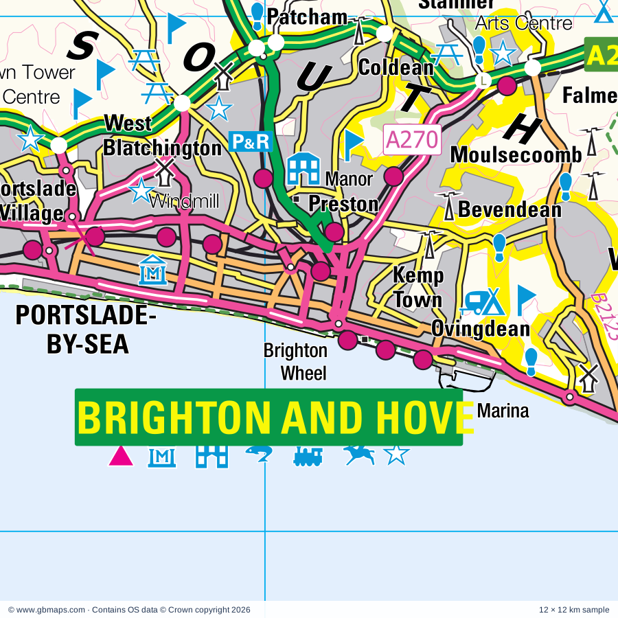
Brighton and Hove regional road map. Full 60 × 60 km PDF, SVG and Illustrator files, with a free PDF sample.

GBMAPS.COM

Brighton and Hove Regional Road Map

Call Us Now for Help01751 473136

GREAT BRITAIN ROAD ATLAS · 1:250,000 GB-540-0120

Brighton and Hove & surrounding area

Explore the full 60 × 60 km Brighton and Hove regional road map at 1:250,000, covering Uckfield, Lewes, Cuckfield, Crowborough, Heathfield. Compare the complete coverage below; a detailed PDF sample is available free.

BRIGHTON AND HOVE & SURROUNDING AREAREGIONAL ROAD MAP
60 × 60 km · Full map previewDownload the free SVG ↓

INSIDE THE FULL 60 × 60 KM MAP

Explore the Brighton and Hove map area

1:250,000 cartography

Towns, villages & places

More mapped places (210)
  • Dorking
  • Chailey
  • Newick
  • Spithurst
  • Fletching
  • Isfield
  • Cooksbridge
  • Barcombe
  • Wivelsfield
  • Streat
  • Plumpton
  • Danehill
  • Hamsey
  • Maresfield
  • Offham
  • Nutley
  • Ditchling
  • Westmeston
  • Ringmer
  • Broyle Side
  • Fairwarp
  • Keymer
  • Framfield
  • Hassocks
  • Buxted
  • Shortgate
  • Halland
  • Highbrook
  • Ardingly
  • Ansty
  • Glyndebourne
  • Clayton
  • Brook Street
  • Falmer
  • Blackboys
  • Stanmer
  • Wych Cross
  • Laughton
  • Glynde
  • Hurstpierpoint
  • Sharpthorne
  • Beddingham
  • Poundgate
  • Iford
  • Pyecombe
  • West Hoathly
  • Hickstead
  • Albourne
  • Balcombe
  • Bolney
  • Rodmell
  • Whitesmith
  • Twineham
  • Firle
  • Staplefield
  • Ripe
  • Southease
  • Waldron
  • Cross in Hand
  • Chiddingly
  • Poynings
  • Chalvington
  • Warninglid
  • Wineham
  • Blackstone
  • Slaugham
  • Five Ashes
  • Telscombe
  • Tarring Neville
  • Handcross
  • Selmeston
  • Fulking
  • Piddinghoe
  • Woodmancote
  • Hartfield
  • Burlow
  • South Heighton
  • Horam
  • Maynard's Green
  • Withyham
  • Rotherfield
  • Boarshead
  • Crabtree
  • Edburton
  • Cowfold
  • Henfield
  • Berwick
  • Argos Hill
  • Arlington
  • Vines Cross
  • Small Dole
  • Mayfield
  • Felbridge
  • Bishopstone
  • Broad Oak
  • Cade Street
  • Hellingly
  • Alfriston
  • Dormans Park
  • Littleworth
  • Copthorne
  • Warbleton
  • Wilmington
  • Colgate
  • Coggins Mill
  • Litlington
  • Mark Cross
  • Chapel Cross
  • Cowden
  • Maplehurst
  • Nuthurst
  • Groombridge
  • Felcourt
  • Ashurst
  • Ashurst
  • Dormansland
  • Tinsley Green
  • Blackham
  • Punnett's Town
  • Newchapel
  • Cowbeech
  • Folkington
  • Burstow
  • Copsale
  • Tidebrook
  • Bramber
  • Botolphs
  • Three Cups Corner
  • Lingfield
  • Stunts Green
  • Fordcombe
  • Westdean
  • Filching
  • Markbeech
  • Wannock
  • Frant
  • Dial Post
  • Smallfield
  • Herstmonceux
  • Southwater
  • Horne
  • Willingdon
  • Shipley
  • Dallington
  • Hever
  • Rusper
  • Dragons Green
  • Hookwood
  • Hankham
  • Wiston
  • Charlwood
  • Speldhurst
  • Penshurst
  • Stone Cross
  • Outwood
  • Lancing
  • Ashington
  • Friston
  • Chiddingstone
  • East Dean
  • Crowhurst
  • Warnham
  • Burwash
  • Wartling
  • Coolham
  • Stonegate
  • Kingsfold
  • Brightling
  • Westham
  • Washington
  • Bidborough
  • Itchingfield
  • Salfords
  • Penhurst
  • Thakeham
  • Coneyhurst
  • Hooe
  • Findon
  • Abingworth
  • Newdigate
  • Pevensey Bay
  • Slinfold
  • Sidlow
  • Leigh
  • Capel
  • Pembury
  • Parkgate
  • Ticehurst
  • Hooe Common
  • Rowhook
  • Kipping's Cross
  • Lamberhurst
  • Leigh
  • Ockley
  • Hildenborough
  • Kilndown
  • Walliswood
  • Tudeley
  • Matfield
  • Capel
  • Coldharbour
  • Brenchley
  • Brockham
  • Whetsted
  • Hadlow
  • Wotton
  • Wotton
  • Beltring
  • Hale Street
  • Laddingford

Roads across this sheet

M23, A21, A22, A23, A24, A25, A26, A27, A29, A217, A227, A228, A259, A262, A264, A265, A267, A269, A270, A271, A272, A273, A275, A277

More road numbers

A280, A281, A283, A293, A295, A2003, A2004, A2010, A2011, A2014, A2021, A2023, A2025, A2029, A2031, A2032, A2037, A2038, A2040, A2044, A2219, A2220, A2270, A2280, A2290, A2300, B245, B269, B2010, B2017, B2021, B2023, B2026, B2027, B2028, B2029, B2034, B2036, B2037, B2042, B2066, B2087, B2095, B2096, B2099, B2100, B2101, B2102, B2103, B2104, B2106, B2109, B2110, B2111, B2112, B2113, B2114, B2115, B2116, B2117, B2118, B2119, B2120, B2121, B2122, B2123, B2124, B2126, B2127, B2133, B2135, B2137, B2139, B2157, B2160, B2161, B2162, B2167, B2169, B2176, B2180, B2183, B2184, B2185, B2188, B2191, B2192, B2193, B2194, B2195, B2203, B2223, B2237, B2247, B2249, B2260, B2272

Rivers & waterways

Cuckmere River, River Adur, River Arun, River Beult, River Dudwell, River Eden, River Medway, River Mole, River Ouse, River Rother, Waller's Haven

Landmarks & landscape

Abbotswood Nature Reserve, Adventure Activity Centre, Alfriston Clergy House, Anne of Cleves House, Barbican House Museum, Arlington Reservoir Nature Reserve, Ashburnham Place, Ashdown Forest Lama Park, Ashdown Forest Nature Reserve, Ashdown Forest Visitor Centre, Bateman's, Bayham Abbey, Bayham Abbey (remains of), SOUTH DOWNS NATIONAL PARK

More named features

Bayham Old Abbey (remains of), Beachy Head Countryside Centre, Beech Hurst, Bentley Motor Museum, Blackberry Farm, Bluebell Railway Museum, Bolebroke Castle, Borde Hill Gardens, Bough Beech Nature Reserve Visitor Centre, Bramber Castle, Brighton Centre, George Street Gallery,, Brighton Racecourse, Brighton Sea Life Centre, British Engineerium, Booth Museum of Natural History, Brighton Museum and Art Gallery, British Wildlife Centre, Brockwood Nature Reserve, Brough Beech Nature Reserve, Buchan Country Park, Buchan Country Park Countryside Centre, Chailey Common Nature Reserve, Chailey Windmill and Rural Life Museum, Chanctonbury Ring, Charleston Farmhouse, Chequer Mead, Chiddingstone Castle, Cissbury Ring, Coombes Farm, Crawley Museum Centre, Crypt Gallery, Cuckfield Museum, Devil's Dyke, Ditchling Beacon Nature Reserve, Ditchling Common Country Park, Ditchling Museum, Dorking and District Museum, Drusilla Zoo, East Grinstead Town Museum, Eastbourne Miniature Steam Railway Park, Eden Valley Museum, Finchcocks, Firle Place, Foredown Tower Visitor Centre, Fort Fun, Gardner Arts Centre, Gatwick Aviation Museum, Glynde Place, Great and Little Earls Wood Nature Reserve, Greenwich Meridian Memorial, Groombridge Place Gardens, Hammerwood Park, Hannah Peschar Gallery, Harrisons Rocks, Haxted Watermill, Haysden Country Park, Heaven Farm, Henfield Museum, Herstmonceux Castle, Herstmonceux Castle Gardens, Hever Castle, Hickstead Showground, Hidden Spring Vineyard, High Beeches Gardens, High Rocks, High Salvington Windmill, Holly Gate Cactus Garden, Holmbush Farm World, Holmes Hill Estate, Hop Farm Family Park, Horsham Museum, Hove Museum and Art Gallery, Huxley's Experience (Birds of Prey Centre), Ifield Watermill, Indoor Rock Climbing Centre, Jack and Jill Windmills, Jarvis Brook Country Park, Kitty Hawk Solar Farm, Knepp Castle (rems of), Knockhatch Adventure Park, Ladyland Farm, Lamberhurst Vineyards, Lavender Line (Tourist Railway), Leechpool & Owlbeech Wood Nature Reserve, Leith Hill Wood, Lewes Castle, Lingfield Park Racecourse, Litlington Horse, Lowfield Heath Windmill, Lullington Heath Nature Reserve, Marle Place Garden, Marlipins Museum, Mecchanical Memories Museum, Meeting House, Michelham Priory (remains of), Michelham Priory Watermill, Middle Farm Countryside Centre, Mill Hill Nature Reserve, Millennium Seed Bank, Monastery, Monk's House, Moorlands, Motor Cycle Scramble Track, National Museum of Penny Slot Machines, Newhaven Fort, Newhaven Fort, Scuba Centre, Newhaven Local and Maritime Museum, Nutley Windmill, Nymans, Paradise Family Leisure Park, Patcham Windmill, Penshurst Place, Penshurst Place and Gardens, Penshurst Vineyards, Pevensey Castle, Pevensey Levels Nature Reserve, Plumpton Racecourse, Polegate Windmill, Preston Manor, Raystede Centre for Animal Welfare, Reigate Priory Museum, Royal Pavilion, Saint Hill Manor, Saltdean Lido, Scotney Castle, Scotney Old Castle & Gardens, Seaford Museum of Local History, Seven Sisters Country Park, Seven Sisters Sheep Centre, Seven Sisters Visitor Centre, Sheffield Park Garden, Shipley Windmill, Shoreham Airport Visitor Centre, South of England Centre, Southwater Country Park, Spa Valley Railway, Spring Barn Farm Park, St Mary's House, Standen, Steyning Museum, Stoneywish, The Blue Idol Meeting House, The Bluebell Railway, The Bradness Gallery, The Brighton Toy and Model Museum, Brighton Fishing Museum, The Long Man of Wilmington, The Long Man of Wilmington (Hill Figure), The Observatory Science Centre, The Pottery, The Priest House, The Redoubt, RNLI Lifeboat Museum, Museum of Shops, Eastbourne Heritage Centre, The Turner Dumbrell Workshops, Tilgate Park Country Park, Tonbridge Castle, Tresure Island, Tulleys Farm, Tunbridge Wells Museum, Volks Railway, Wakehurst Place Royal Botanic Gardens, Warnham Nature Reserve, Warnham Nature Reserve Visitor Centre, Washbrooks Farm Park, Weir Wood Reservoir Nature Reserve, Wellingham Walled Herb Garden, West Blatchington Windmill, Worth Abbey, Worthing Museum and Art Gallery
Local authority & parish coverage

Wholly or partly within the full map rectangle. These boundaries are coverage information, not additional artwork layers.

  • Adur DistrictWholly within
  • Arun DistrictPartly within
  • Crawley DistrictWholly within
  • Eastbourne DistrictWholly within
  • Guildford DistrictPartly within
  • Horsham DistrictPartly within
  • Lewes DistrictWholly within
  • Maidstone DistrictPartly within
  • Mid Sussex DistrictWholly within
  • Mole Valley DistrictPartly within
  • Reigate and Banstead DistrictPartly within
  • Rother DistrictPartly within
  • Sevenoaks DistrictPartly within
  • Tandridge DistrictPartly within
  • The City of Brighton and HoveWholly within
  • Tonbridge and Malling DistrictPartly within
  • Tunbridge Wells DistrictPartly within
  • Waverley DistrictPartly within
  • Wealden DistrictPartly within
  • Worthing DistrictPartly within
Wards & electoral divisions 242 areas
  • Angmering & Findon Ward (part)
  • Ardingly, Balcombe & Turners Hill Ward
  • Arlington Ward
  • Ashurst Wood & East Grinstead South Ward
  • Bewbush & North Broadfield Ward
  • Bexhill St. Marks Ward (part)
  • Billingshurst Ward (part)
  • Bletchingley & Nutfield Ward (part)
  • Bourne Ward (part)
  • Bramber, Upper Beeding & Woodmancote Ward
  • Brasted, Chevening & Sundridge Ward (part)
  • Broadbridge Heath Ward
  • Broadfield Ward
  • Broadwater Ward
  • Brockham, Betchworth, Buckland, Box Hill & Headley Ward (part)
  • Brunswick & Adelaide Ward
  • Buckingham Ward
  • Burgess Hill Dunstall Ward
  • Burgess Hill Franklands Ward
  • Burgess Hill Leylands Ward
  • Burgess Hill Meeds & Hammonds Ward
  • Burgess Hill St. Andrews Ward
  • Burgess Hill Victoria Ward
  • Burstow, Horne & Outwood Ward
  • Burwash & the Weald Ward (part)
  • Buxted Ward
  • Cage Green & Angel Ward
  • Capel, Leigh, Newdigate & Charlwood Ward
  • Castle Ward (part)
  • Catsfield & Crowhurst Ward (part)
  • Central Hove Ward
  • Central Ward
  • Chailey, Barcombe & Hamsey Ward
  • Chiddingly, East Hoathly & Waldron Ward
  • Churchill Ward
  • Cokeham Ward
  • Coldean & Stanmer Ward
  • Colgate & Rusper Ward
  • Copthorne & Worth Ward
  • Cowden and Hever Ward
  • Cowfold, Shermanbury & West Grinstead Ward
  • Crawley Down Ward
  • Crowborough Central Ward
  • Crowborough Jarvis Brook Ward
  • Crowborough North Ward
  • Crowborough South East Ward
  • Crowborough South West Ward
  • Crowborough St. Johns Ward
  • Cuckfield, Bolney & Ansty Ward
  • Culverden Ward
  • Danehill & Fletching Ward
  • Denne Ward
  • Devonshire Ward
  • Ditchling & Westmeston Ward
  • Dorking North Ward (part)
  • Dorking South Ward (part)
  • Dormansland & Felbridge Ward
  • Downland Villages Ward
  • Durrington Ward
  • Earlswood & Whitebushes Ward (part)
  • East Grinstead Ashplats Ward
  • East Grinstead Baldwins Ward
  • East Grinstead Herontye Ward
  • East Grinstead Imberhorne Ward
  • East Grinstead Town Ward
  • East Saltdean & Telscombe Cliffs Ward
  • East and West Peckham, Mereworth & Wateringbury Ward (part)
  • Eastbrook Ward
  • Edenbridge North and East Ward
  • Edenbridge South and West Ward
  • Effingham Ward (part)
  • Ewhurst & Ellens Green Ward (part)
  • Ferring Ward (part)
  • Forest Row Ward
  • Forest Ward
  • Framfield & Cross-in-Hand Ward
  • Frant & Wadhurst Ward
  • Furnace Green Ward
  • Gaisford Ward
  • Godstone Ward (part)
  • Goldsmid Ward
  • Goring Ward (part)
  • Gossops Green & North East Broadfield Ward
  • Hadlow Down & Rotherfield Ward
  • Hailsham Central Ward
  • Hailsham East Ward
  • Hailsham North Ward
  • Hailsham North West Ward
  • Hailsham South Ward
  • Hailsham West Ward
  • Hampden Park Ward
  • Handcross & Pease Pottage Ward
  • Hangleton & Knoll Ward
  • Hanover & Elm Grove Ward
  • Hartfield Ward
  • Hassocks Ward
  • Haywards Heath Ashenground Ward
  • Haywards Heath Bentswood & Heath Ward
  • Haywards Heath Franklands Ward
  • Haywards Heath Lucastes & Bolnore Ward
  • Haywards Heath North Ward
  • Heathfield North Ward
  • Heathfield South Ward
  • Heene Ward
  • Hellingly Ward
  • Henfield Ward
  • Herstmonceux & Pevensey Levels Ward (part)
  • High Brooms Ward
  • Higham Ward (part)
  • Hildenborough Ward (part)
  • Hillside Ward
  • Holbrook East Ward
  • Holbrook West Ward
  • Hollingdean & Fiveways Ward
  • Holmwoods & Beare Green Ward
  • Horam & Punnetts Town Ward
  • Horley Central & South Ward
  • Horley East & Salfords Ward
  • Horley West & Sidlow Ward
  • Hurst Green & Ticehurst Ward (part)
  • Hurstpierpoint Ward
  • Ifield Ward
  • Itchingfield, Slinfold & Warnham Ward (part)
  • Judd Ward
  • Kemptown Ward
  • Kingston Ward
  • Langley Green & Tushmore Ward
  • Langney Ward
  • Leigh and Chiddingstone Causeway Ward (part)
  • Lewes Bridge Ward
  • Lewes Castle Ward
  • Lewes Priory Ward
  • Limpsfield Ward (part)
  • Lindfield Rural & High Weald Ward
  • Lindfield Ward
  • Lingfield, Crowhurst & Tandridge Ward (part)
  • Lower Willingdon Ward
  • Maidenbower Ward
  • Manor Ward
  • Marden & Yalding Ward (part)
  • Maresfield Ward
  • Marine Ward
  • Marine Ward
  • Mash Barn Ward
  • Mayfield & Five Ashes Ward
  • Meads Ward
  • Meadvale & St. John's Ward (part)
  • Mickleham, Westcott & Okewood Ward (part)
  • Moulsecoomb & Bevendean Ward
  • Newhaven North Ward
  • Newhaven South Ward
  • Newick Ward
  • North Battle, Netherfield & Whatlington Ward (part)
  • North Portslade Ward
  • Northbrook Ward (part)
  • Northgate & West Green Ward
  • Nuthurst & Lower Beeding Ward
  • Offington Ward
  • Old Town Ward
  • Ouse Valley & Ringmer Ward
  • Oxted South Ward (part)
  • Paddock Wood Ward (part)
  • Pantiles Ward
  • Park Ward
  • Patcham & Hollingbury Ward
  • Peacehaven East Ward
  • Peacehaven North Ward
  • Peacehaven West Ward
  • Pembury & Capel Ward
  • Penshurst, Fordcombe and Chiddingstone Ward
  • Pevensey Bay Ward
  • Peverel Ward
  • Plumpton, Streat, East Chiltington & St. John Ward
  • Polegate Central Ward
  • Polegate North Ward
  • Polegate South & Willingdon Watermill Ward
  • Pound Hill North & Forge Wood Ward
  • Pound Hill South & Worth Ward
  • Preston Park Ward
  • Queen's Park Ward
  • Ratton Ward
  • Redhill East Ward (part)
  • Regency Ward
  • Reigate Ward (part)
  • Roffey North Ward
  • Roffey South Ward
  • Rottingdean & West Saltdean Ward
  • Round Hill Ward
  • Rudgwick Ward (part)
  • Rural Tunbridge Wells Ward (part)
  • Rusthall & Speldhurst Ward
  • Salvington Ward
  • Seaford Central Ward
  • Seaford East Ward
  • Seaford North Ward
  • Seaford South Ward
  • Seaford West Ward
  • Seal & Weald Ward (part)
  • Selden Ward
  • Sherwood Ward
  • South Downs Ward
  • South Park & Woodhatch Ward
  • South Portslade Ward
  • Southborough & Bidborough Ward
  • Southgate Ward
  • Southlands Ward
  • Southwater North Ward
  • Southwater South & Shipley Ward
  • Southwick Green Ward
  • Sovereign Ward
  • St. Anthony's Ward
  • St. James' Ward
  • St. John's Ward
  • St. Mary's Ward
  • St. Nicolas Ward
  • Steyning & Ashurst Ward
  • Stone Cross Ward
  • Storrington & Washington Ward (part)
  • Tarring Ward
  • Three Bridges Ward
  • Tilgate Ward
  • Tillingbourne Ward (part)
  • Trafalgar Ward
  • Trench Ward (part)
  • Uckfield East Ward
  • Uckfield New Town Ward
  • Uckfield North Ward
  • Uckfield Ridgewood & Little Horsted Ward
  • Upper Willingdon Ward
  • Upperton Ward
  • Vauxhall Ward
  • West Chiltington, Thakeham & Ashington Ward (part)
  • West Hill & North Laine Ward
  • Westbourne & Poets' Corner Ward
  • Westdene & Hove Park Ward
  • Westerham and Crockham Hill Ward (part)
  • Whitehawk & Marina Ward
  • Widewater Ward
  • Wish Ward
  • Withyham Ward
  • Wivelsfield Ward
  • Woodingdean Ward
Civil parishes & communities 198 areas
  • Abinger CP (part)
  • Albourne CP
  • Alciston CP
  • Alfriston CP
  • Ansty and Staplefield CP
  • Ardingly CP
  • Arlington CP
  • Ashburnham CP (part)
  • Ashington CP
  • Ashurst CP
  • Ashurst Wood CP
  • Balcombe CP
  • Barcombe CP
  • Battle CP (part)
  • Beddingham CP
  • Berwick CP
  • Betchworth CP (part)
  • Bexhill-on-Sea CP (part)
  • Bidborough CP
  • Billingshurst CP (part)
  • Bletchingley CP (part)
  • Bolney CP
  • Bramber CP
  • Brasted CP (part)
  • Brenchley and Matfield CP (part)
  • Brightling CP (part)
  • Broadbridge Heath CP
  • Brockham CP (part)
  • Buckland CP (part)
  • Burgess Hill CP
  • Burstow CP
  • Burwash CP (part)
  • Buxted CP
  • Capel CP
  • Capel CP
  • Catsfield CP (part)
  • Chailey CP
  • Chalvington with Ripe CP
  • Charlwood CP
  • Chevening CP (part)
  • Chiddingly CP
  • Chiddingstone CP
  • Clapham CP (part)
  • Colgate CP
  • Collier Street CP (part)
  • Coombes CP
  • Cowden CP
  • Cowfold CP
  • Crowborough CP
  • Crowhurst CP
  • Cuckfield CP
  • Cuckmere Valley CP
  • Dallington CP
  • Danehill CP
  • Ditchling CP
  • Dormansland CP
  • East Chiltington CP
  • East Dean and Friston CP
  • East Grinstead CP
  • East Hoathly with Halland CP
  • East Peckham CP (part)
  • Edenbridge CP
  • Effingham CP (part)
  • Etchingham CP (part)
  • Ewhurst CP (part)
  • Falmer CP
  • Felbridge CP
  • Ferring CP (part)
  • Findon CP (part)
  • Firle CP
  • Fletching CP
  • Forest Row CP
  • Framfield CP
  • Frant CP
  • Fulking CP
  • Glynde CP
  • Godstone CP (part)
  • Goudhurst CP (part)
  • Hadlow CP (part)
  • Hadlow Down CP
  • Hailsham CP
  • Hamsey CP
  • Hartfield CP
  • Hassocks CP
  • Haywards Heath CP
  • Heathfield and Waldron CP
  • Hellingly CP
  • Henfield CP
  • Herstmonceux CP
  • Hever CP
  • Hildenborough CP (part)
  • Holmwood CP
  • Hooe CP (part)
  • Horam CP
  • Horley CP
  • Horne CP
  • Horsham CP
  • Horsmonden CP (part)
  • Horsted Keynes CP
  • Hurstpierpoint and Sayers Common CP
  • Iford CP
  • Isfield CP
  • Itchingfield CP
  • Kingston Near Lewes CP
  • Lamberhurst CP
  • Lancing CP
  • Laughton CP
  • Leigh CP
  • Leigh CP (part)
  • Lewes CP
  • Limpsfield CP (part)
  • Lindfield CP
  • Lindfield Rural CP
  • Lingfield CP
  • Little Horsted CP
  • Long Man CP
  • Lower Beeding CP
  • Maresfield CP
  • Mayfield and Five Ashes CP
  • Nettlestead CP (part)
  • Newdigate CP
  • Newhaven CP
  • Newick CP
  • Newtimber CP
  • Ninfield CP (part)
  • North Horsham CP
  • Nutfield CP (part)
  • Nuthurst CP
  • Ockley CP
  • Outwood CP
  • Oxted CP (part)
  • Paddock Wood CP (part)
  • Peacehaven CP
  • Pembury CP
  • Penhurst CP (part)
  • Penshurst CP
  • Pevensey CP
  • Piddinghoe CP
  • Plumpton CP
  • Polegate CP
  • Poynings CP
  • Pyecombe CP
  • Ringmer CP
  • Rodmell CP
  • Rotherfield CP
  • Rottingdean CP
  • Rudgwick CP (part)
  • Rusper CP
  • Rusthall CP
  • Salfords and Sidlow CP
  • Seaford CP
  • Selmeston CP
  • Sevenoaks Weald CP (part)
  • Shere CP (part)
  • Shermanbury CP
  • Shipley CP
  • Slaugham CP
  • Slinfold CP (part)
  • Sompting CP
  • South Heighton CP
  • Southborough CP
  • Southease CP
  • Southwater CP
  • Speldhurst CP
  • St. Ann (Without) CP
  • St. John (Without) CP
  • Steyning CP
  • Storrington and Sullington CP (part)
  • Streat CP
  • Sundridge with Ide Hill CP (part)
  • Tandridge CP (part)
  • Tarring Neville CP
  • Telscombe CP
  • Thakeham CP (part)
  • Ticehurst CP (part)
  • Turners Hill CP
  • Twineham CP
  • Uckfield CP
  • Upper Beeding CP
  • Wadhurst CP
  • Warbleton CP
  • Warnham CP
  • Wartling CP
  • Washington CP
  • West Chiltington CP (part)
  • West Grinstead CP
  • West Hoathly CP
  • Westerham CP (part)
  • Westham CP
  • Westmeston CP
  • Willingdon and Jevington CP
  • Wiston CP
  • Withyham CP
  • Wivelsfield CP
  • Woodmancote CP
  • Worth CP
  • Wotton CP (part)
  • Yalding CP (part)

Source: the GBMaps road atlas, OS Boundary-Line and postcode mapping datasets. Source editions are being checked for publication. Unmarked boundary names are wholly within the sheet; “part” means the map edge crosses the area.

Place lists are selected from the map source, not a complete gazetteer. Named features describe the cartography; visitor facilities and opening status are not verified. The free sample covers only 12 × 12 km of this larger sheet.

INSIDE YOUR DOWNLOAD

A proper road map, in useful formats

Road classifications, towns and villages, railways, rivers, landscape detail and tourist symbols, brought together in the GBMaps regional road atlas style.

PDF filePDFSVG fileSVGAdobe Illustrator AI fileAi

PDF for the finished map. SVG and layered Illustrator artwork for adapting colours, adding your own information and preparing designs.

THE FINISHED SHEET

Designed for print and presentation

Map coverage
60 × 60 km
Sample coverage
12 × 12 km
Print layout
A3 landscape · enlarged 1:250k cartography
Sheet furniture
Border, scale bar, key & north arrow

A few useful details

What changes when I select another square?

Select a surrounding square to bring it into the centre and reveal the maps around it. Each square is a different 60 × 60 km map. The preview, free sample and selected download change together. Neighbouring sheets overlap by 30 km so you can choose the coverage that suits you.

Is the free sample a vector map?

The on-page detail is an SVG. The free download is a separate 12 × 12 km PDF with a link to the full map. Please retain its copyright credits and product link when sharing it.

Can I buy a larger combined map?

These downloads are individual ready-made sheets. Contact GBMaps if you need a larger combined area.

FREE PDF SAMPLE

Your free map sample

Your free 12 × 12 km sample includes a link back to this map, so you can return for the full area whenever you need it.

Download free PDF sample ↓

Get your Brighton and Hove map

Map download bundle

£24.00including VATOne payment

Pay securely

One payment. Your map stays open.

Your map download

Your map files

Preparing your download…

Checking your private download link…

Your map downloads

Already bought a map?

Find the downloads from your purchases.

Enter the email address you used at checkout. We’ll email you a private link to your available map downloads.