Barton-upon-Humber regional road map. Full 60 × 60 km PDF, SVG and Illustrator files, with a free PDF sample.

GBMAPS.COM

Barton-upon-Humber Regional Road Map

Call Us Now for Help01751 473136

GREAT BRITAIN ROAD ATLAS · 1:250,000 RY-52

Barton-upon-Humber & surrounding area

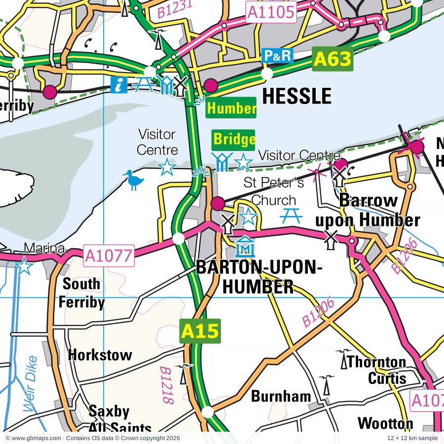
Explore the full 60 × 60 km Barton-upon-Humber regional road map at 1:250,000, covering Upon Hull, Bridge, Kingston, Humber, Hessle. Compare the complete coverage below; a detailed PDF sample is available free.

BARTON-UPON-HUMBER & SURROUNDING AREAREGIONAL ROAD MAP
60 × 60 km · Full map previewDownload the free SVG ↓

INSIDE THE FULL 60 × 60 KM MAP

Explore the Barton-upon-Humber map area

1:250,000 cartography

Towns, villages & places

More mapped places (229)
  • Croxton
  • Habrough
  • Kirmington
  • Paull
  • Brocklesby
  • Elsham
  • Worlaby
  • Bonby
  • Anlaby
  • Horkstow
  • Keelby
  • Thorngumbald
  • Willerby
  • North Ferriby
  • Swanland
  • Bigby
  • Stallingborough
  • Preston
  • Wrawby
  • Bilton
  • Ryehill
  • Searby
  • Healing
  • Ganstead
  • Riby
  • Burstwick
  • Dunswell
  • Grasby
  • Keyingham
  • Appleby
  • Welton
  • Aylesby
  • Skidby
  • Coniston
  • Swine
  • Lelley
  • Wressle
  • Howsham
  • Sunk Island
  • Wawne
  • Winteringham
  • Thearne
  • Brough
  • Sproatley
  • Elloughton
  • Woodmansey
  • Low Risby
  • Laceby
  • Elstronwick
  • Ottringham
  • Bentley
  • Broughton
  • Roxby
  • Santon
  • Cadney
  • Brantingham
  • Riplingham
  • Cabourne
  • Swallow
  • Caistor
  • High Risby
  • Burton Pidsea
  • Meaux
  • North Kelsey
  • Humbleton
  • Bradley
  • Scawby
  • Weel
  • Nettleton
  • Ellerker
  • Walkington
  • Skirlaugh
  • Coleby
  • Cuxwold
  • West Newton
  • Flinton
  • Whitton
  • New Ellerby
  • Winestead
  • Thealby
  • Moortown
  • Rothwell
  • Beelsby
  • High Hunsley
  • Owstwick
  • Hibaldstow
  • Fitling
  • Patrington
  • Alkborough
  • Roos
  • Normanby
  • Tickton
  • Holton le Moor
  • Garton
  • Hatcliffe
  • Everthorpe
  • Routh
  • Bishop Burton
  • Long Riston
  • Waltham
  • Rise
  • Hilston
  • Broomfleet
  • Rimswell
  • Flixborough
  • Aldbrough
  • Croxby
  • Tunstall
  • Brigsley
  • Redbourne
  • Grimston
  • Faxfleet
  • New Waltham
  • Thornton le Moor
  • Manton
  • Thoresway
  • Little Hatfield
  • Great Hatfield
  • Brandy Wharf
  • South Newbald
  • Welwick
  • Thorganby
  • Waxholme
  • Garthorpe
  • Hotham
  • North Newbald
  • Arram
  • Leconfield
  • Fockerby
  • Amcotts
  • Leven
  • Hollym
  • Catwick
  • Humberston
  • Weeton
  • Great Cowden
  • Blacktoft
  • Adlingfleet
  • North Owersby
  • Messingham
  • Goxhill
  • Usselby
  • Aike
  • Newport
  • Etton
  • Sigglesthorne
  • Swinhope
  • Waddingham
  • Holmpton
  • Scorborough
  • Brookenby
  • Mappleton
  • Skeffling
  • Gunness
  • Grainsby
  • Luddington
  • Ousefleet
  • Seaton
  • Osgodby
  • Kingerby
  • Kirkby
  • Brandesburton
  • Sancton
  • Walesby
  • Keadby
  • Snitterby
  • Rolston
  • Burshill
  • Yokefleet
  • Binbrook
  • Gilberdyke
  • Burringham
  • Whitgift
  • South Dalton
  • Tetney
  • Scotter
  • Althorpe
  • Scotterthorpe
  • Grayingham
  • Sandholme
  • Lockington
  • Beswick
  • Derrythorpe
  • Atterby
  • Scotton
  • Bishopbridge
  • Eastoft
  • Bishop Norton
  • Tealby
  • Easington
  • Tetney Lock
  • Blyborough
  • Northorpe
  • Lund
  • Glentham
  • Kilnwick
  • Watton
  • Goodmanham
  • Ludborough
  • North Cotes
  • Willoughton
  • Beltoft
  • Susworth
  • Bursea
  • Fulstow
  • Marshchapel
  • Kelstern
  • Moor End
  • Hemswell
  • Sand Hole
  • Utterby
  • Shiptonthorpe
  • Laughton
  • Eskham
  • Londesborough
  • Blyton
  • Owston Ferry
  • Aisby
  • Pilham
  • Fotherby
  • Wildsworth
  • Grainthorpe
  • Corringham
  • Yarburgh
  • Everingham
  • Burnby
  • Hayton
  • Ludney
  • Alvingham

Roads across this sheet

M62, M180, M181, A15, A16, A18, A46, A159, A160, A161, A163, A164, A165, A180, A614, A631, A1029, A1031, A1033, A1034, A1035, A1077, A1079, A1084

More road numbers

A1098, A1103, A1105, A1136, A1165, A1166, A1173, A1174, A1243, B1201, B1203, B1204, B1205, B1206, B1207, B1208, B1210, B1211, B1212, B1213, B1216, B1218, B1219, B1225, B1230, B1231, B1232, B1233, B1237, B1238, B1239, B1240, B1242, B1243, B1244, B1246, B1247, B1248, B1362, B1374, B1392, B1398, B1400, B1402, B1430, B1433, B1434, B1444, B1445, B1450, B1501

Rivers & waterways

Holderness Drain, Land Drain, Leven Canal, Louth Canal, Market Weighton Canal, Monk Dike, New River Ancholme, North Kelsey Beck, Old River Ancholme, River Ancholme, River Eau, River Foulness

More waterways

River Freshney, River Hull, River Torne, Stainforth & Keadby Canal, Watton Beck

Landmarks & landscape

Baysgarth House Museum, Wilderspin National School, Beverley Art Gallery, Beverley Minster, Beverley Racecourse, Blacktoft Sands, Bradley Woods Nature Reserve, Brandy Wharf Cider Centre, Brumby Common, Bull Sand Fort, Burnby Hall Gardens, Burton Constable Country Park, Burton Constable Hall

More named features

Caistor Arts and Heritage Centre, Cleethorpes Coast Light Railway, Cleethorpes Country Park, Covenham Reservoir Nature Reserve, East Hull Community Farm, Elsham Hall Country Park, Far Ings NNR Visitor Centre, Far Ings Nature Reserve, Ferens Art Gallery, Hull History Centre, ArtLink, Fort Paull, Fort Paull Visitor Centre, Freshney Parkway Nature Reserve, Gainsborough Old Hall, Gainsthorpe Medieval Village, Great Northern Railway, Haile Sand Fort, Hall Park Farm, Hedon Museum, Hemswell Craft and Design Centre, Honeysuckle Animal Farm, Hornsea Mere Nature Reserve, Hornsea Museum, Humber Bridge Country Park, Humber Estuary Discovery Centre, Immingham Museum, Johnstones Farm Centre, Julians's Bower, Kay Kendall Memorial & Lighthouse Museum, Kirton Pottery, Maritime Museum, Wilberforce House Museum and Georgian Houses, Hull and East Riding Museum, Hull Museum of Transport, Spurn Lightship Museum, Hands on History, Mount Pleasant Mill, Museum of Rural Life, National Fishing Heritage Centre, Normanby Hall, Normanby Hall Country Park, Normanby Park Fishing Museum, National Fishing Heritage Centre, Normanby Hall, North Lincs Museum, Owston Ferry The Old Smithy and Heritage Centre, Pleasure Island Theme Park, Pulfin Bog Nature Reserve, Skidby Windmill and Museum of East Riding Life, South Ferriby Marina, St Mary's Church, St Peter's Church, Stewart's Collection Museum, The Deep, The Jungle, The Pink Pig, Thornton Abbey, Time Warp Discovery Centre, Newby Centre, Tophill Low Nature Reserve, Tophill Low Nature Reserve Visitor Centre, Underground Bunker, Visitor Centre, Waltham Windmill, Water Sports Activities, Waters Edge Country Park, Watton Nature Reserve
Local authority & parish coverage

Wholly or partly within the full map rectangle. These boundaries are coverage information, not additional artwork layers.

  • Bassetlaw DistrictPartly within
  • City of Kingston upon HullWholly within
  • East Lindsey DistrictPartly within
  • East Riding of YorkshirePartly within
  • North East LincolnshireWholly within
  • North LincolnshirePartly within
  • West Lindsey DistrictPartly within
Wards & electoral divisions 91 areas
  • Ashby Central Ward
  • Ashby Lakeside Ward
  • Avenue Ward
  • Axholme Central Ward (part)
  • Axholme North Ward (part)
  • Axholme South Ward (part)
  • Barton Ward
  • Beckingham Ward (part)
  • Beverley & Newland Ward
  • Beverley Rural Ward (part)
  • Binbrook Ward (part)
  • Boothferry Ward
  • Bottesford Ward
  • Bricknell Ward
  • Brigg & Wolds Ward
  • Broughton & Scawby Ward
  • Brumby Ward
  • Burringham & Gunness Ward
  • Burton upon Stather & Winterton Ward
  • Caistor and Yarborough Ward
  • Central Ward
  • Cottingham North Ward
  • Cottingham South Ward
  • Croft Baker Ward
  • Crosby & Park Ward
  • Dale Ward
  • Derringham Ward
  • Drypool Ward
  • East Marsh Ward
  • East Wolds and Coastal Ward (part)
  • Ferry Ward
  • Freshney Ward
  • Frodingham Ward
  • Fulstow Ward (part)
  • Gainsborough East Ward (part)
  • Gainsborough North Ward
  • Gainsborough South-West Ward (part)
  • Grimoldby Ward (part)
  • Haverstoe Ward
  • Hemswell Ward (part)
  • Heneage Ward
  • Hessle Ward
  • Holderness Ward
  • Holton-le-Clay & North Thoresby Ward
  • Howdenshire Ward (part)
  • Humberston and New Waltham Ward
  • Immingham Ward
  • Ings Ward
  • Kelsey Wold Ward
  • Kingsway with Lincoln Gardens Ward
  • Kingswood Ward
  • Longhill & Bilton Grange Ward
  • Marfleet Ward
  • Market Rasen Ward (part)
  • Marshchapel & Somercotes Ward (part)
  • Messingham Ward
  • Mid Holderness Ward
  • Minster and Woodmansey Ward
  • Newington & Gipsyville Ward
  • North Carr Ward
  • North Holderness Ward (part)
  • Orchard Park Ward
  • Park Ward
  • Pickering Ward
  • Pocklington Provincial Ward (part)
  • Ridge Ward
  • Scartho Ward
  • Scotter and Blyton Ward (part)
  • Sidney Sussex Ward
  • Snaith, Airmyn, Rawcliffe and Marshland Ward (part)
  • South East Holderness Ward (part)
  • South Hunsley Ward
  • South Ward
  • South West Holderness Ward
  • Southcoates Ward
  • St. Andrew's & Docklands Ward
  • St. Mary's Ward
  • Sutton Ward
  • Tetney Ward
  • Town Ward
  • Tranby Ward
  • University Ward
  • Waddingham and Spital Ward (part)
  • Waltham Ward
  • West Carr Ward
  • West Marsh Ward
  • Willerby and Kirk Ella Ward
  • Wold View Ward
  • Wolds Ward
  • Wolds Weighton Ward (part)
  • Yarborough Ward
Civil parishes & communities 265 areas
  • Aldbrough CP
  • Alkborough CP
  • Alvingham CP (part)
  • Amcotts CP
  • Anlaby with Anlaby Common CP
  • Appleby CP
  • Ashby Parkland CP
  • Ashby cum Fenby CP
  • Atwick CP (part)
  • Aylesby CP
  • Barmby Moor CP (part)
  • Barnetby Le Wold CP
  • Barnoldby Le Beck CP
  • Barrow upon Humber CP
  • Barton CP
  • Beckingham CP (part)
  • Beelsby CP
  • Belton CP (part)
  • Beswick CP (part)
  • Beverley CP
  • Bewholme CP (part)
  • Bielby CP (part)
  • Bigby CP
  • Bilton CP
  • Binbrook CP
  • Bishop Burton CP
  • Bishop Norton CP
  • Blacktoft CP
  • Blyborough CP
  • Blyton CP (part)
  • Bonby CP
  • Bottesford CP
  • Brackenborough with Little Grimsby CP (part)
  • Bradley CP
  • Brandesburton CP (part)
  • Brantingham CP
  • Brigg CP
  • Brigsley CP
  • Brocklesby CP
  • Brookenby CP
  • Broomfleet CP
  • Broughton CP
  • Burringham CP
  • Burstwick CP
  • Burton Constable CP
  • Burton Pidsea CP
  • Burton upon Stather CP
  • Cabourne CP
  • Cadney CP
  • Caenby CP (part)
  • Caistor CP
  • Calcethorpe with Kelstern CP (part)
  • Catwick CP
  • Cherry Burton CP
  • Claxby CP
  • Conisholme CP (part)
  • Coniston CP
  • Corringham CP (part)
  • Cottingham CP
  • Covenham St. Bartholomew CP
  • Covenham St. Mary CP
  • Crowle and Ealand CP (part)
  • Croxton CP
  • Dalton Holme CP
  • Easington CP (part)
  • East Butterwick CP
  • East Ferry CP
  • East Garton CP
  • East Halton CP
  • East Ravendale CP
  • East Stockwith CP (part)
  • Eastoft CP (part)
  • Eastrington CP (part)
  • Elkington CP (part)
  • Ellerby CP
  • Ellerker CP
  • Elloughton-cum-Brough CP
  • Elsham CP
  • Elstronwick CP
  • Epworth CP (part)
  • Etton CP
  • Everingham CP (part)
  • Flixborough CP
  • Fotherby CP
  • Fulstow CP
  • Gainsborough CP (part)
  • Garthorpe and Fockerby CP
  • Gilberdyke CP
  • Glentham CP (part)
  • Goodmanham CP
  • Goxhill CP
  • Grainsby CP
  • Grainthorpe CP (part)
  • Grasby CP
  • Grayingham CP
  • Great Coates CP
  • Great Limber CP
  • Gunness CP
  • Habrough CP
  • Halsham CP
  • Harpswell CP (part)
  • Hatcliffe CP
  • Hatfield CP
  • Hawerby cum Beesby CP
  • Haxey CP (part)
  • Hayton CP
  • Healing CP
  • Hedon CP
  • Hemswell CP
  • Hemswell Cliff CP (part)
  • Hessle CP
  • Hibaldstow CP
  • Hollym CP
  • Holme upon Spalding Moor CP (part)
  • Holmpton CP
  • Holton Le Clay CP
  • Holton Le Moor CP
  • Horkstow CP
  • Hornsea CP (part)
  • Hotham CP
  • Humberston CP
  • Humbleton CP
  • Immingham CP
  • Irby CP
  • Keadby with Althorpe CP
  • Keddington CP (part)
  • Keelby CP
  • Keyingham CP
  • Kilpin CP (part)
  • Kirk Ella CP
  • Kirmington CP
  • Kirmond Le Mire CP
  • Kirton in Lindsey CP
  • Laceby CP
  • Laughton CP
  • Laxton CP (part)
  • Leconfield CP
  • Leven CP
  • Lockington CP
  • Londesborough CP
  • Ludborough CP
  • Luddington and Haldenby CP
  • Ludford CP (part)
  • Lund CP
  • Manton CP
  • Mappleton CP
  • Market Weighton CP
  • Marshchapel CP (part)
  • Melton Ross CP
  • Messingham CP
  • Middle Rasen CP (part)
  • Middleton CP (part)
  • Molescroft CP
  • Morton CP (part)
  • Nettleton CP
  • New Holland CP
  • New Waltham CP
  • Newbald CP
  • Newport CP
  • Normanby Le Wold CP
  • North Cave CP
  • North Cockerington CP (part)
  • North Cotes CP
  • North Dalton CP (part)
  • North Ferriby CP
  • North Kelsey CP
  • North Killingholme CP
  • North Ormsby CP
  • North Somercotes CP (part)
  • North Thoresby CP
  • North Willingham CP (part)
  • Northorpe CP
  • Nunburnholme CP (part)
  • Osgodby CP
  • Ottringham CP
  • Owersby CP
  • Owston Ferry CP (part)
  • Patrington CP
  • Paull CP
  • Pilham CP
  • Pocklington CP (part)
  • Preston CP
  • Redbourne CP
  • Reedness CP (part)
  • Riby CP
  • Rimswell CP
  • Rise CP
  • Riston CP
  • Roos CP
  • Rothwell CP
  • Routh CP
  • Rowley CP
  • Roxby cum Risby CP
  • Sancton CP
  • Saxby All Saints CP
  • Scawby CP
  • Scotter CP
  • Scotton CP
  • Searby cum Owmby CP
  • Seaton CP
  • Shipton Thorpe CP
  • Sigglesthorne CP
  • Skeffling CP
  • Skidby CP
  • Skirlaugh CP
  • Snitterby CP
  • Somerby CP
  • South Cave CP
  • South Cliffe CP
  • South Cockerington CP (part)
  • South Ferriby CP
  • South Kelsey CP
  • South Killingholme CP
  • South Somercotes CP (part)
  • Spaldington CP (part)
  • Springthorpe CP (part)
  • Sproatley CP
  • Stainton Le Vale CP
  • Stallingborough CP
  • Sunk Island CP
  • Swallow CP
  • Swanland CP
  • Swine CP
  • Swinhope CP
  • Tealby CP (part)
  • Tetney CP
  • Thonock CP
  • Thoresway CP
  • Thorganby CP
  • Thorngumbald CP
  • Thornton Curtis CP
  • Tickton CP
  • Twin Rivers CP (part)
  • Ulceby CP
  • Utterby CP
  • Waddingham CP
  • Waithe CP
  • Walesby CP (part)
  • Walkeringham CP (part)
  • Walkington CP
  • Waltham CP
  • Warter CP (part)
  • Watton CP (part)
  • Wawne CP
  • Welton CP
  • Welwick CP
  • West Butterwick CP
  • West Halton CP
  • West Rasen CP (part)
  • West Ravendale CP
  • Whitton CP
  • Wildsworth CP
  • Willerby CP
  • Willoughton CP
  • Winteringham CP
  • Winterton CP
  • Withernsea CP
  • Withernwick CP
  • Wold Newton CP
  • Woodmansey CP
  • Wootton CP
  • Worlaby CP
  • Wrawby CP
  • Wyham cum Cadeby CP
  • Yarburgh CP

Source: the GBMaps road atlas, OS Boundary-Line and postcode mapping datasets. Source editions are being checked for publication. Unmarked boundary names are wholly within the sheet; “part” means the map edge crosses the area.

Place lists are selected from the map source, not a complete gazetteer. Named features describe the cartography; visitor facilities and opening status are not verified. The free sample covers only 12 × 12 km of this larger sheet.

INSIDE YOUR DOWNLOAD

A proper road map, in useful formats

Road classifications, towns and villages, railways, rivers, landscape detail and tourist symbols, brought together in the GBMaps regional road atlas style.

PDF filePDFSVG fileSVGAdobe Illustrator AI fileAi

PDF for the finished map. SVG and layered Illustrator artwork for adapting colours, adding your own information and preparing designs.

THE FINISHED SHEET

Designed for print and presentation

Map coverage
60 × 60 km
Sample coverage
12 × 12 km
Print layout
A3 landscape · enlarged 1:250k cartography
Sheet furniture
Border, scale bar, key & north arrow

A few useful details

What changes when I select another square?

Select a surrounding square to bring it into the centre and reveal the maps around it. Each square is a different 60 × 60 km map. The preview, free sample and selected download change together. Neighbouring sheets overlap by 30 km so you can choose the coverage that suits you.

Is the free sample a vector map?

The on-page detail is an SVG. The free download is a separate 12 × 12 km PDF with a link to the full map. Please retain its copyright credits and product link when sharing it.

Can I buy a larger combined map?

These downloads are individual ready-made sheets. Contact GBMaps if you need a larger combined area.

FREE PDF SAMPLE

Your free map sample

Your free 12 × 12 km sample includes a link back to this map, so you can return for the full area whenever you need it.

Download free PDF sample ↓

Get your Barton-upon-Humber map

Map download bundle

£24.00including VATOne payment

Pay securely

One payment. Your map stays open.

Your map download

Your map files

Preparing your download…

Checking your private download link…

Your map downloads

Already bought a map?

Find the downloads from your purchases.

Enter the email address you used at checkout. We’ll email you a private link to your available map downloads.