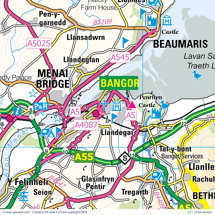
Bangor regional road map. Full 60 × 60 km PDF, SVG and Illustrator files, with a free PDF sample.

GBMAPS.COM

Bangor Regional Road Map

Call Us Now for Help01751 473136

GREAT BRITAIN ROAD ATLAS · 1:250,000 GB-240-0360

Bangor & surrounding area

Explore the full 60 × 60 km Bangor regional road map at 1:250,000, covering Bangor, Caernarfon, Rhosgadfan, Llangefni, Nefyn. Compare the complete coverage below; a detailed PDF sample is available free.

BANGOR & SURROUNDING AREAREGIONAL ROAD MAP
60 × 60 km · Full map previewDownload the free SVG ↓

INSIDE THE FULL 60 × 60 KM MAP

Explore the Bangor map area

1:250,000 cartography

Towns, villages & places

More mapped places (166)
  • Llanwnda
  • Bontnewydd
  • Pontllyfni
  • Groeslon
  • Malltraeth
  • Hermon
  • Llangaffo
  • Llangadwaladr
  • Penygroes
  • Rhostryfan
  • Aberffraw
  • Caeathro
  • Trefdraeth
  • Bethel
  • Carmel
  • Llanllyfni
  • Brynsiencyn
  • Talysarn
  • Nebo
  • Pont-rug
  • Nasareth
  • Waunfawr
  • Nantlle
  • Llangristiolus
  • Trefor
  • Cerrigceinwen
  • Llanrug
  • Bethel
  • Bryn Du
  • Llanddaniel Fab
  • Llanedwen
  • Betws Garmon
  • Llanfaelog
  • Gaerwen
  • Bwlch-derwin
  • Dothan
  • Y Felinheli
  • Llanaelhaearn
  • Cwm-y-glo
  • Rhosneigr
  • Mona
  • Llanddeiniolen
  • Penisa'r Waun
  • Capel Gwyn
  • Seion
  • Cenin
  • Bodffordd
  • Llithfaen
  • Bryncir
  • Ceint
  • Llanberis
  • Penmynydd
  • Deiniolen
  • Rhyd-Ddu
  • Llynfaes
  • Rhos-meirch
  • Garndolbenmaen
  • Dinorwig
  • Pentir
  • Rhiwlas
  • Bryngwran
  • Llwyndyrys
  • Llangybi
  • Llangwyllog
  • Llanfairyneubwll
  • Talwrn
  • Pistyll
  • Dolbenmaen
  • Rhoslan
  • Trefor
  • Caergeiliog
  • Rhoscefnhir
  • Glasinfryn
  • Llanarmon
  • Nant Peris
  • Bodedern
  • Llechcynfarwy
  • Golan
  • Tregarth
  • Llandegfan
  • Chwilog
  • Valley
  • Pentraeth
  • Beddgelert
  • Carmel
  • Llanynghenedl
  • Llanystumdwy
  • Morfa Nefyn
  • Pen-llyn
  • Capel Coch
  • Tal-y-bont
  • Llannor
  • Abererch
  • Llansadwrn
  • Boduan
  • Llanbedrgoch
  • Trearddur
  • Pentrefelin
  • Rachub
  • Llantrisant
  • Llanllechid
  • Edern
  • Groesffordd
  • Llanfachraeth
  • Llanerchymedd
  • Penmorfa
  • Nantmor
  • Llanfigael
  • Efailnewydd
  • Bethania
  • Brynteg
  • Tyn-y-gongl
  • Elim
  • Llanddeusant
  • Ceidio
  • Tremadog
  • Llandyfrydog
  • Benllech
  • Penrhos
  • Prenteg
  • Llanfwrog
  • Llanddona
  • Crymlyn
  • Marianglas
  • Llanbabo
  • Llanfaes
  • Dinas
  • Llanallgo
  • Croesor
  • Brynrefail
  • Llanfaethlu
  • Garreg
  • Garnfadryn
  • City Dulas
  • Tudweiliog
  • Abergwyngregyn
  • Llangoed
  • Rhos-y-bol
  • Llanfrothen
  • Moelfre
  • Minffordd
  • Rhosgoch
  • Llanbedrog
  • Llaniestyn
  • Carreglefn
  • Penmon
  • Portmeirion
  • Rhyd
  • Penrhyndeudraeth
  • Gadfa
  • Rhyd-wyn
  • Mynytho
  • Penllech
  • Ynys
  • Talsarnau
  • Botwnnog
  • Tanygrisiau
  • Llandegwning
  • Maentwrog
  • Morfa
  • Pen-y-graig
  • Eisingrug
  • Bryncroes
  • Llangwnnadl
  • Gellilydan
  • Rhydlios

Roads across this sheet

A5, A487, A496, A497, A498, A499, A545, A4080, A4085, A4086, A4087, A4244, A4971, A5025, A5108, A5114, A5152, A5153, A5154, B4354, B4366, B4391, B4409, B4410

More road numbers

B4411, B4412, B4413, B4415, B4417, B4418, B4419, B4421, B4422, B4545, B4547, B4573, B5107, B5108, B5109, B5110, B5111, B5112, B5420

Rivers & waterways

Afon Cefni, Afon Dwyfach, Afon Dwyfor, Afon Dwyryd, Afon Glaslyn, Afon Llugwy, Afon Rhyd-hir

Landmarks & landscape

Aber Falls, Anglesey Angora Bunny Farm, Anglesey Circuit, Anglesey Model Village, Anglesey Sea Zoo, Anthur Waunfawr, Bangor Cathedral, Bangor Museum and Art Gallery, Barclodiad y Gwres Burial Chamber, Beacon Climbing Centre, Beaumaris Castle, Beaumaris Castle (World Heritage Site), SNOWDONIA NATIONAL PARK

More named features

Beaumaris Gaol Museum, Beaumaris Courthouse Museum, Bodowyr Burial Chamber, Breakwater Country Park, Bryn Celli Ddu Burial Chamber, Brynkir Woollen Mill, Burial Chamber, Caer Gybi Roman Fort, Caer Leb, Caernarfon Air World (Museum), Caernarfon Castle, Caernarfon Castle (World Heritage Site), Canolfan Crafftau Tan Lan Craft Centre, Cartio Mon Karting, Castell Aberlleiniog Heritage Attraction, Castell Bryn-gwyn, Cefni Reservoir Nature Reserve, Coed Bronturnor Nature Reserve, Coed Elernion Nature Reserve, Criccieth Castle, Cwm Idwal Nature Reserve, Cwm Llan Waterfalls, Cytaiu'r Gwyddelod, Din Dryfol Burial Chamber (remains of), Din Lligwy Settlement, Dolbadarn Castle, Dwyfor Rabbit Farm, Electric Mountain Visitor Centre, Ffestiniog Railway, Ffestiniog Railway Museum, Ffynnon Gybi, Foel Farm Park, Gelert's Grave, Gerddi Haulfre Gardens, Glynllifon Country Park, Greenwood Forest Park, Gypsy Wood Park, Hafod Eryri Visitor Centre, Hafoty Farm House, Harlech Castle, Harlech Castle (World Heritage Site), Hen Capel Lligwy, Hen Capel Lligwy, Din Lligwy Settlement, Holyhead Maritime Museum, Inigo Jones Slateworks, Lavan Sands Nature Reserve, Llanberis Lakeside Railway, Lleyn Historical and Maritime Museum, Lligwy Burial Chamber, Lloyd George Museum and Highgate Cottage, Llyn Alaw, Llyn Parc Mawr (Wildlife Pool), Llynon Mill (Windmill), Llywelyn Cottage, Melin Howell Watermill, Menai Suspension Bridge, Moelfre Seawatch Centre, Morfa Harlech National Nature Reserve, Nant Gwtheyrn Welsh Language and Heritage Centre, Newborough Warren (Warren Ynys Llanddwyn), Oriel Ynys Mon, Padarn Country Park, Parc Glasfryn, Pass of Aberglaslyn, Beauty Spot, Penarth Fawr, Penmon Priory (remains of), Penrhos Coastal Park (Nature Reserve), Penrhosfeilw Standing Stones, Penrhyn Castle, Pili Palas (Butterfly Palace), Plas Brondanw Gardens, Plas Menai (National Watersports Centre), Plas Newydd, Plas Tan-y-Bwlch Woodland Gardens, Portmeirion, Presaddfed Burial Chambers, Quarry Hospital Museum, Welsh Slate Museum, Electric Mountain, Royal Welch Fusiliers Museum, Segontium Roman Museum, SEGONTIVM ROMAN FORT, Sarn Pottery, Sea Salt Works & Visitor Centre, Snowdon Mountain Railway, South Stack Cliffs Nature Reserve, Spinneys, Aber Ogwen Nature Reserve, St Cybi's Well, St Seiriol's Well, Standing Stone, Stone Science, Swtan, Sygun Copper Mine, Visitor Centre, TH Parry-Williams Museum, Tacla Taid, The Anglesey Transport and Agriculture Museum, The Roman Steps, Trefignath Burial Chamber, Tregehelydd Standing Stone, Ty Mawr Standing Stone, Ty Newydd Burial Chamber, Valley Lakes Reserve, Waterfall, Welsh Highland Railway, Ynys-y-Pandy Slate Mill (ruins), Yr Hwylfan, Oriel Pendeitsh, Yr Wyddfa Nature Reserve
Local authority & parish coverage

Wholly or partly within the full map rectangle. These boundaries are coverage information, not additional artwork layers.

  • Conwy - ConwyPartly within
  • Gwynedd - GwyneddPartly within
  • Sir Ynys Mon - Isle of AngleseyPartly within
Wards & electoral divisions 70 areas
  • Abererch ED
  • Abersoch gyda Llanengan ED (part)
  • Aethwy ED
  • Arllechwedd ED (part)
  • Bethel a'r Felinheli ED
  • Betws-y-Coed and Trefriw ED (part)
  • Bodowyr ED
  • Bowydd a'r Rhiw ED (part)
  • Bro Aberffraw ED
  • Bro'r Llynnoedd ED
  • Bryn ED (part)
  • Cadnant ED
  • Caerhun ED (part)
  • Canol Bangor ED
  • Canol Bethesda ED
  • Canol Tref Caernarfon ED
  • Canolbarth Mon ED
  • Cefni ED
  • Clynnog ED
  • Criccieth ED
  • Crigyll ED
  • Cwm-y-glo ED
  • De Pwllheli ED
  • Deiniolen ED
  • Dewi ED
  • Diffwys a Maenofferen ED (part)
  • Dolbenmaen ED
  • Dwyrain Bangor ED
  • Dwyrain Porthmadog ED
  • Efailnewydd a Buan ED
  • Gerlan ED
  • Glaslyn ED
  • Glyder ED
  • Gogledd Pwllheli ED
  • Gorllewin Porthmadog ED
  • Harlech a Llanbedr ED (part)
  • Hendre ED
  • Llanbedrog gyda Mynytho ED (part)
  • Llanberis ED
  • Llanllyfni ED
  • Llanrug ED
  • Llanwnda ED
  • Llanystumdwy ED
  • Lligwy ED
  • Menai ED
  • Morfa Nefyn a Thudweiliog ED
  • Nefyn ED
  • Pandy ED (part)
  • Parc a'r Mynydd ED
  • Peblig ED
  • Pen draw Llyn ED (part)
  • Pen-y-groes ED
  • Penisa'r-waun ED
  • Penmaenmawr ED (part)
  • Penrhyndeudraeth ED
  • Rachub ED
  • Seiriol ED
  • Talybolion ED (part)
  • Teigl ED (part)
  • Trawsfynydd ED (part)
  • Tre-garth a Mynydd Llandygai ED
  • Tref Cybi ED
  • Tryfan ED
  • Twrcelyn ED (part)
  • Waunfawr ED
  • Y Bontnewydd ED
  • Y Faenol ED
  • Y Groeslon ED
  • Ynys Gybi ED
  • Yr Eifl ED
Civil parishes & communities 87 areas
  • Aber Community (part)
  • Aberdaron Community (part)
  • Aberffraw Community
  • Amlwch Community (part)
  • Bangor Community
  • Beaumaris Community
  • Beddgelert Community
  • Bethesda Community
  • Betws Garmon Community
  • Bodedern Community
  • Bodffordd Community
  • Bodorgan Community
  • Bontnewydd Community
  • Botwnnog Community (part)
  • Bryngwran Community
  • Buan Community
  • Caerhun Community (part)
  • Caernarfon Community
  • Capel Curig Community (part)
  • Clynnog Community
  • Criccieth Community
  • Cwm Cadnant Community
  • Cylch-y-Garn Community (part)
  • Dolbenmaen Community
  • Dolwyddelan Community (part)
  • Ffestiniog Community (part)
  • Harlech Community (part)
  • Holyhead Community
  • Llanbedr Community (part)
  • Llanbedrog Community
  • Llanberis Community
  • Llanddaniel Fab Community
  • Llanddeiniolen Community
  • Llanddona Community
  • Llanddyfnan Community
  • Llandwrog Community
  • Llandygai Community
  • Llaneilian Community (part)
  • Llanengan Community (part)
  • Llaneugrad Community
  • Llanfachraeth Community
  • Llanfaelog Community
  • Llanfaethlu Community
  • Llanfair Community (part)
  • Llanfair Pwllgwyngyll Community
  • Llanfair-Mathafarn-Eithaf Community
  • Llanfair-yn-Neubwll Community
  • Llanfairfechan Community (part)
  • Llanfihangel Ysgeifiog Community
  • Llanfrothen Community
  • Llangefni Community
  • Llangoed Community
  • Llangristiolus Community
  • Llanidan Community
  • Llanllechid Community
  • Llanllyfni Community
  • Llannerch-y-Medd Community
  • Llannor Community
  • Llanrug Community
  • Llanwnda Community
  • Llanystumdwy Community
  • Maentwrog Community (part)
  • Mechell Community (part)
  • Menai Bridge Community
  • Moelfre Community
  • Nefyn Community
  • Penmaenmawr Community (part)
  • Penmynydd Community
  • Penrhyndeudraeth Community
  • Pentir Community
  • Pentraeth Community
  • Pistyll Community
  • Porthmadog Community
  • Pwllheli Community
  • Rhoscolyn Community
  • Rhosybol Community (part)
  • Rhosyr Community
  • Talsarnau Community
  • Trawsfynydd Community (part)
  • Trearddur Community
  • Tref Alaw Community
  • Trefor a Llanaelhaearn Community
  • Trewalchmai Community
  • Tudweiliog Community
  • Valley Community
  • Waunfawr Community
  • Y Felinheli Community

Source: the GBMaps road atlas, OS Boundary-Line and postcode mapping datasets. Source editions are being checked for publication. Unmarked boundary names are wholly within the sheet; “part” means the map edge crosses the area.

Place lists are selected from the map source, not a complete gazetteer. Named features describe the cartography; visitor facilities and opening status are not verified. The free sample covers only 12 × 12 km of this larger sheet.

INSIDE YOUR DOWNLOAD

A proper road map, in useful formats

Road classifications, towns and villages, railways, rivers, landscape detail and tourist symbols, brought together in the GBMaps regional road atlas style.

PDF filePDFSVG fileSVGAdobe Illustrator AI fileAi

PDF for the finished map. SVG and layered Illustrator artwork for adapting colours, adding your own information and preparing designs.

THE FINISHED SHEET

Designed for print and presentation

Map coverage
60 × 60 km
Sample coverage
12 × 12 km
Print layout
A3 landscape · enlarged 1:250k cartography
Sheet furniture
Border, scale bar, key & north arrow

A few useful details

What changes when I select another square?

Select a surrounding square to bring it into the centre and reveal the maps around it. Each square is a different 60 × 60 km map. The preview, free sample and selected download change together. Neighbouring sheets overlap by 30 km so you can choose the coverage that suits you.

Is the free sample a vector map?

The on-page detail is an SVG. The free download is a separate 12 × 12 km PDF with a link to the full map. Please retain its copyright credits and product link when sharing it.

Can I buy a larger combined map?

These downloads are individual ready-made sheets. Contact GBMaps if you need a larger combined area.

FREE PDF SAMPLE

Your free map sample

Your free 12 × 12 km sample includes a link back to this map, so you can return for the full area whenever you need it.

Download free PDF sample ↓

Get your Bangor map

Map download bundle

£24.00including VATOne payment

Pay securely

One payment. Your map stays open.

Your map download

Your map files

Preparing your download…

Checking your private download link…

Your map downloads

Already bought a map?

Find the downloads from your purchases.

Enter the email address you used at checkout. We’ll email you a private link to your available map downloads.