Ballater regional road map. Full 60 × 60 km PDF, SVG and Illustrator files, with a free PDF sample.

GBMAPS.COM

Ballater Regional Road Map

Call Us Now for Help01751 473136

GREAT BRITAIN ROAD ATLAS · 1:250,000 GB-330-0810

Ballater & surrounding area

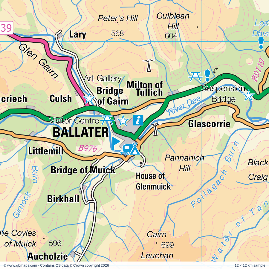
Explore the full 60 × 60 km Ballater regional road map at 1:250,000, covering Ballater, Alford, Dufftown, Huntly, Corgarff. Compare the complete coverage below; a detailed PDF sample is available free.

BALLATER & SURROUNDING AREAREGIONAL ROAD MAP
60 × 60 km · Full map previewDownload the free SVG ↓

INSIDE THE FULL 60 × 60 KM MAP

Explore the Ballater map area

1:250,000 cartography

Towns, villages & places

  • Ballater
  • Alford
  • Dufftown
  • Huntly
  • Corgarff
  • Strathdon
  • Bellabeg
  • Forbestown
  • Waterside
  • Heugh-head
  • Belnacraig
  • Chapeltown
  • Coilacriech
  • Towie
  • Migvie
  • Glenkindie
  • Coynach
  • Abergeldie
More mapped places (54)
  • Tomintoul
  • Crathie
  • Auchnarrow
  • Ordie
  • Kildrummy
  • Tomnavoulin
  • Tarland
  • Cabrach
  • Dinnet
  • Mossat
  • Auchbreck
  • Lumsden
  • Glenlivet
  • Coull
  • Bridgend
  • Braemar
  • Wheedlemont
  • Aboyne
  • Birsemore
  • Rosehill
  • Rhynie
  • Cottown
  • Tullynessle
  • Perkhill
  • Lumphanan
  • Sliemore
  • Montgarrie
  • Clatt
  • Birse
  • Tormore
  • Cromdale
  • Inverey
  • Advie
  • Marypark
  • Ballogie
  • Kennethmont
  • Cults
  • Kirkney
  • Muir
  • Gartly
  • Marywell
  • Nethy Bridge
  • Duncanstone
  • Culdrain
  • Torry
  • Leslie
  • Bridgend
  • Oldtown
  • Camerory
  • Glaschoil
  • Hillhead
  • Thomastown
  • Brideswell
  • Dava

Roads across this sheet

A93, A95, A97, A920, A938, A939, A940, A941, A944, A980, B968, B970, B971, B972, B976, B993, B9002, B9008, B9009, B9014, B9094, B9102, B9119, B9136

More road numbers

B9137, B9138, B9158

Rivers & waterways

Allt Connie, Allt Darrarie, Allt Deveron, Allt Garbh Buidhe, Allt a Gheallaidh, Black Water, Burn of Branny, Burn of Cattie, Burn of Lochy, Burn of Loin, Burn of Tennet, Burn of Tulchan

More waterways

Burn of Turret, Bynack Burn, Callater Burn, Clunie Water, Conglass Water, Derry Burn, Deskry Water, Dorback Burn, Dullan Water, Ernan Water, Ey Burn, Feardar Burn, Gadie Burn, Geldie Burn, Girnock Burn, Kirkney Water, Ladder Burn, Lui Water, Pollagach Burn, Quoich Water, River Avon, River Bogie, River Dee, River Deveron, River Divie, River Don, River Dulnain, River Fiddich, River Gairn, River Livet, River Muick, River Nethy, River North Esk, River South Esk, River Spey, Water of Ailnack, Water of Aven, Water of Bogie, Water of Buchat, Water of Caiplich, Water of Dye, Water of Feugh, Water of Lee, Water of Mark, Water of Nochty, Water of Tanar, Water of Tarf, Water of Unich

Landmarks & landscape

Abergeldie Castle, Abernethy Trust Activity Centre, Alford Ski Centre, Alford Valley Railway, Alford- Haughton Country Park, Ardmore Distillery, Auchindoun Castle, Ballater Ski Slope, Visitor Centre, Dee Valley Confectioners, Ballindalloch Castle, Ballindalloch Castle and Gardens, Balmoral Castle, Balmoral Castle Gardens and Grounds, CAIRNGORMS NATIONAL PARK

More named features

Belwade Farm Rescue And Rehoming Centre, Braeloine Visitor Centre, Braemar Castle, Braemar Highland Heritage Centre, Princess Royal and Duke of Fife Memorial Park, Braemar Mountain Sports, Braemar Ski School, Braemar Gallery, Cairn Gorm, Cambus O'May Suspension Bridge, Candacraig House, College of Scalan, Corgarff Castle, Corrylair Farm Trekking Centre, Cragganmore Distillery, Craig Castle, Craigievar Castle, Craigievar Castle Grounds, Culsh Souterrain, Deans Shortbread Factory Visitor Centre, Deeside Activity Park, Dell Lodge, Delnadamph, Dorback Lodge, Forest Lodge, Gairnshiel Lodge, Garden of Kildrummy Castle, Glen Tanar House, Glenbuchat Castle, Glenbuchat Lodge, Glendavan House, Glenfarclas Distillery, Glenfarclas Distillery, Visitor Centre, Glenfiddich Lodge, Glenlivet Distillery, Glenlivet Estate Visitor Centre, Grampian Transport Museum, Alford Heritage Centre, Grantown, House of Glenmuick, Invercauld Bridge, Invercauld House, Inverernan House, Invermark Lodge, Kildrummy Castle, Knockespock House, Leith Hall, Leith Hall, Garden and Estate, Linn of Dee, Linn of Quoich, Little Chapelton Crafts, Lost Gallery, Mar Lodge, Morrone Birkwood Nature Reserve, Peel Ring of Lumphanan, Queen's Well, Revack Estate Garden, Roches Moutonnees, Royal Lochnagar Distillery, Spey Valley Smokehouse, St Mary's Kirk, Stone, The Butterworth Gallery, The Glenlivet Distillery, The Glenlivet Distillery, Visitor Centre, The House of Corse, The McEwan Art Gallery, Tomintoul Distillery, Tomintoul Museum, Tomnaverie (Stone Circle), Tomnavoulin Distillery Visitor Centre
Local authority & parish coverage

Wholly or partly within the full map rectangle. These boundaries are coverage information, not additional artwork layers.

  • AberdeenshirePartly within
  • AngusPartly within
  • HighlandPartly within
  • MorayPartly within
  • Perth and KinrossPartly within
Wards & electoral divisions 12 areas
  • Aboyne, Upper Deeside and Donside Ward (part)
  • Badenoch and Strathspey Ward (part)
  • Banchory and Mid Deeside Ward (part)
  • Blairgowrie and Glens Ward (part)
  • Brechin and Edzell Ward (part)
  • Forres Ward (part)
  • Highland Ward (part)
  • Huntly, Strathbogie and Howe of Alford Ward (part)
  • Kirriemuir and Dean Ward (part)
  • Nairn and Cawdor Ward (part)
  • Speyside Glenlivet Ward (part)
  • West Garioch Ward (part)
Civil parishes & communities 0 areas

    Source: the GBMaps road atlas, OS Boundary-Line and postcode mapping datasets. Source editions are being checked for publication. Unmarked boundary names are wholly within the sheet; “part” means the map edge crosses the area.

    Place lists are selected from the map source, not a complete gazetteer. Named features describe the cartography; visitor facilities and opening status are not verified. The free sample covers only 12 × 12 km of this larger sheet.

    INSIDE YOUR DOWNLOAD

    A proper road map, in useful formats

    Road classifications, towns and villages, railways, rivers, landscape detail and tourist symbols, brought together in the GBMaps regional road atlas style.

    PDF filePDFSVG fileSVGAdobe Illustrator AI fileAi

    PDF for the finished map. SVG and layered Illustrator artwork for adapting colours, adding your own information and preparing designs.

    THE FINISHED SHEET

    Designed for print and presentation

    Map coverage
    60 × 60 km
    Sample coverage
    12 × 12 km
    Print layout
    A3 landscape · enlarged 1:250k cartography
    Sheet furniture
    Border, scale bar, key & north arrow

    A few useful details

    What changes when I select another square?

    Select a surrounding square to bring it into the centre and reveal the maps around it. Each square is a different 60 × 60 km map. The preview, free sample and selected download change together. Neighbouring sheets overlap by 30 km so you can choose the coverage that suits you.

    Is the free sample a vector map?

    The on-page detail is an SVG. The free download is a separate 12 × 12 km PDF with a link to the full map. Please retain its copyright credits and product link when sharing it.

    Can I buy a larger combined map?

    These downloads are individual ready-made sheets. Contact GBMaps if you need a larger combined area.

    FREE PDF SAMPLE

    Your free map sample

    Your free 12 × 12 km sample includes a link back to this map, so you can return for the full area whenever you need it.

    Download free PDF sample ↓

    Get your Ballater map

    Map download bundle

    £24.00including VATOne payment

    Pay securely

    One payment. Your map stays open.

    Your map download

    Your map files

    Preparing your download…

    Checking your private download link…

    Your map downloads

    Already bought a map?

    Find the downloads from your purchases.

    Enter the email address you used at checkout. We’ll email you a private link to your available map downloads.