Ardrossan regional road map. Full 60 × 60 km PDF, SVG and Illustrator files, with a free PDF sample.

GBMAPS.COM

Ardrossan Regional Road Map

Call Us Now for Help01751 473136

GREAT BRITAIN ROAD ATLAS · 1:250,000 GB-210-0630

Ardrossan & surrounding area

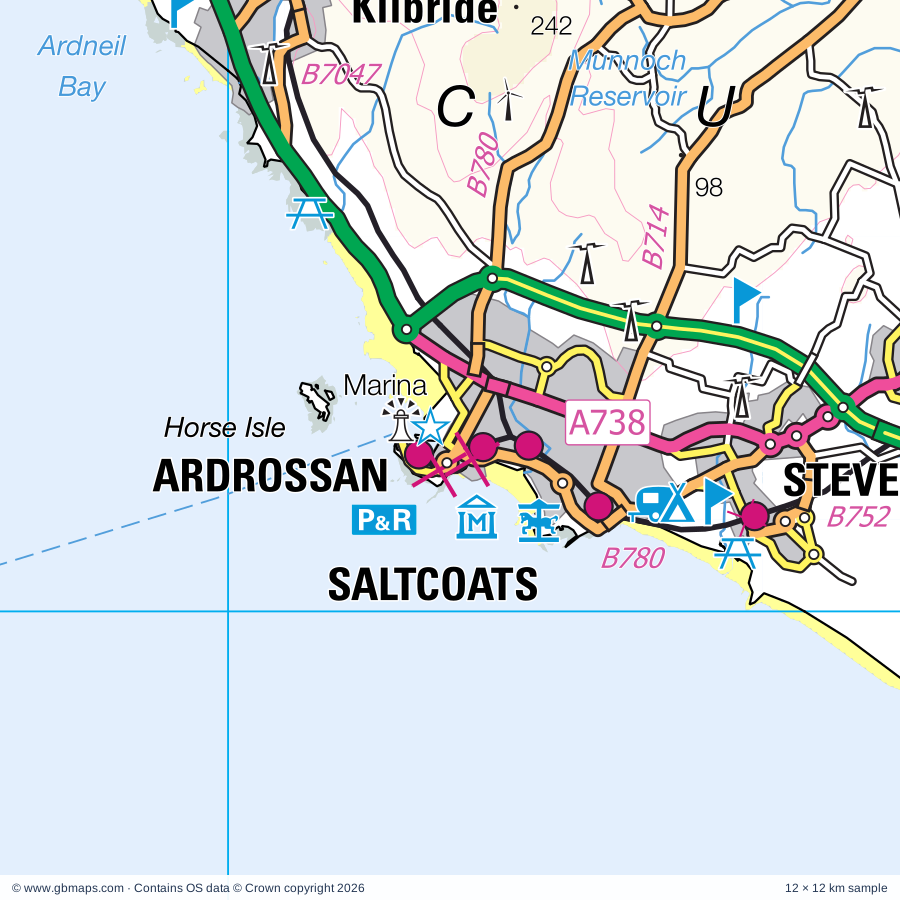
Explore the full 60 × 60 km Ardrossan regional road map at 1:250,000, covering Ardrossan, Saltcoats, Stevenston, Troon, Irvine. Compare the complete coverage below; a detailed PDF sample is available free.

ARDROSSAN & SURROUNDING AREAREGIONAL ROAD MAP
60 × 60 km · Full map previewDownload the free SVG ↓

INSIDE THE FULL 60 × 60 KM MAP

Explore the Ardrossan map area

1:250,000 cartography

Towns, villages & places

More mapped places (66)
  • Corrie
  • Shannochie
  • Kilmory
  • Sannox
  • Sliddery
  • Shiskine
  • Corriecravie
  • Torbeg
  • Kilpatrick
  • Portencross
  • Tormore
  • Blackwaterfoot
  • Dunure
  • Fisherton
  • Auchagallon
  • Lagg
  • Maidens
  • Loans
  • Dalgarven
  • Imachar
  • Monkton
  • Kingarth
  • Lochranza
  • Kirkoswald
  • Drybridge
  • Turnberry
  • Culroy
  • Dundonald
  • Fairlie
  • Pirnmill
  • Perceton
  • Catacol
  • Dalry
  • Thundergay
  • Minishant
  • Symington
  • Springside
  • Highfield
  • Dipple
  • Bogend
  • Gatehead
  • Cunninghamhead
  • Dalrymple
  • South Hourat
  • Crosshouse
  • The Den
  • Knockentiber
  • Auchentiber
  • Glengarnock
  • Longbar
  • Wallacetown
  • Kirkmichael
  • Grogport
  • Crosshill
  • Kilbirnie
  • Hollybush
  • Dailly
  • Skipness
  • Barrmill
  • Beith
  • Burnhouse
  • Claonaig
  • Gateside
  • Straiton
  • Lochwinnoch
  • Gartnagrenach

Roads across this sheet

A70, A71, A79, A83, A713, A719, A736, A737, A738, A759, A760, A841, A844, B706, B707, B714, B730, B739, B741, B742, B743, B744, B746, B747

More road numbers

B748, B749, B750, B751, B752, B769, B776, B777, B778, B779, B780, B781, B782, B784, B785, B786, B787, B842, B879, B880, B881, B889, B896, B7023, B7024, B7025, B7034, B7035, B7045, B7047, B7048, B7049, B7080, B7081, B8001

Rivers & waterways

Annick Water, Carradale Water, Dusk Water, Iorsa Water, Kilmory Water, Lugton Water, Machrie Water, River Ayr, River Calder, River Doon, River Garnock, River Irvine

More waterways

Rye Water, Sliddery Water, Water of Coyle, Water of Girvan

Landmarks & landscape

Arran Adventure, Arran Aromatics, Isle of Arran Brewery, Brodick Castle Visitor Centre, Arran Heritage Museum, Auchagallon Stone Circle, Auchans, Ayr Racecourse, Barr Castle, Beach Park & Magnum Leisure Centre, Harbour Arts Centre, Irvine Sea Angling, Blackrock Boat Hire, Blairquhan Castle, Boat Trips and Cruises, Marina, Brodick Castle, GALLOWAY FOREST PARK

More named features

Brodick Country Park, Brodick Trekking Centre, Burns Monument, Burns National Heritage Park, Robert Burns Birthplace Museum, Cairn, Carn Ban Cairn, Carradale Visitor Centre, Castle, Castle Semple Country Park, Castle Semple Loch Visitor Centre, Cathedral, Cloncaird Castle, Crosbie, Crossraguel Abbey, Croy Brae (Electric Brae), Culzean Castle, Culzean Country Park, Dalgarven Mill, Dalquharran Castle, Dundonald Castle, Eglinton Country Park, Eglinton Country Park Visitor Centre, Fort, Gleann Diomhan Nature Reserve, Glenashdale Falls, Greenacres Curling Rink, Heads of Ayr Farm Park, Hunterston House, Isle of Arran Distillery, Kelburn, Kilbrannan Chapel, Killochan Castle, Kilmory Workshop, Kilpatrick Dun, Kilwinning Abbey, Kilwinning Heritage Centre, Lamlash Boat Hire, Lochranza Castle, Lochranza Field Study Centre, Lochwinnoch Museum, Lochwinnoch RSPB Nature Reserve, Machrie Moor Stone Circles, Machrie Moor Stone Circles, Moss Farm Road Stone Circle, Maybole Collegiate Church, Monument, Moss Farm Road Stone Circle, Mount Stuart, Museum of Cumbraes, North Ayrshire Museum, Outdoor Centre, Pencil Monument, Pleasureland, Robertson Museum and Aquarium, Rozelle House, Burns Cottage, Scottish Maritime Museum, Irvine Burns Club Museum, Shewalton Sandpits Nature Reserve, Shewalton Wood Nature Reserve, Simon Thorborn Potter, Skipness Castle, Skipness Castle, Kilbrannan Chapel, Souter Johnnie's Cottage, St Blane's Church, Sunadale Cott, Swan Pond, Culzean Country Park Vistor Centre, The Cathedral of the Isles, The Museum of Ayrshire Country Life and Costume, The Stables Museum, The Steading, The Whins, Torrylin Chambered Cairn, Torrylinn Creamery, Visitor Centre, West Kilbride Museum
Local authority & parish coverage

Wholly or partly within the full map rectangle. These boundaries are coverage information, not additional artwork layers.

  • Argyll and ButePartly within
  • East AyrshirePartly within
  • North AyrshirePartly within
  • RenfrewshirePartly within
  • South AyrshirePartly within
Wards & electoral divisions 25 areas
  • Annick Ward (part)
  • Ardrossan Ward
  • Arran Ward
  • Ayr East Ward
  • Ayr North Ward
  • Ayr West Ward
  • Doon Valley Ward (part)
  • Garnock Valley Ward (part)
  • Girvan and South Carrick Ward (part)
  • Irvine East Ward (part)
  • Irvine South Ward
  • Irvine West Ward
  • Isle of Bute Ward (part)
  • Johnstone North, Kilbarchan, Howwood and Lochwinnoch Ward (part)
  • Kilmarnock South Ward (part)
  • Kilmarnock West and Crosshouse Ward (part)
  • Kilwinning Ward
  • Kintyre and the Islands Ward (part)
  • Kyle Ward (part)
  • Maybole, North Carrick and Coylton Ward (part)
  • North Coast Ward (part)
  • Prestwick Ward
  • Saltcoats and Stevenston Ward
  • South Kintyre Ward (part)
  • Troon Ward
Civil parishes & communities 0 areas

    Source: the GBMaps road atlas, OS Boundary-Line and postcode mapping datasets. Source editions are being checked for publication. Unmarked boundary names are wholly within the sheet; “part” means the map edge crosses the area.

    Place lists are selected from the map source, not a complete gazetteer. Named features describe the cartography; visitor facilities and opening status are not verified. The free sample covers only 12 × 12 km of this larger sheet.

    INSIDE YOUR DOWNLOAD

    A proper road map, in useful formats

    Road classifications, towns and villages, railways, rivers, landscape detail and tourist symbols, brought together in the GBMaps regional road atlas style.

    PDF filePDFSVG fileSVGAdobe Illustrator AI fileAi

    PDF for the finished map. SVG and layered Illustrator artwork for adapting colours, adding your own information and preparing designs.

    THE FINISHED SHEET

    Designed for print and presentation

    Map coverage
    60 × 60 km
    Sample coverage
    12 × 12 km
    Print layout
    A3 landscape · enlarged 1:250k cartography
    Sheet furniture
    Border, scale bar, key & north arrow

    A few useful details

    What changes when I select another square?

    Select a surrounding square to bring it into the centre and reveal the maps around it. Each square is a different 60 × 60 km map. The preview, free sample and selected download change together. Neighbouring sheets overlap by 30 km so you can choose the coverage that suits you.

    Is the free sample a vector map?

    The on-page detail is an SVG. The free download is a separate 12 × 12 km PDF with a link to the full map. Please retain its copyright credits and product link when sharing it.

    Can I buy a larger combined map?

    These downloads are individual ready-made sheets. Contact GBMaps if you need a larger combined area.

    FREE PDF SAMPLE

    Your free map sample

    Your free 12 × 12 km sample includes a link back to this map, so you can return for the full area whenever you need it.

    Download free PDF sample ↓

    Get your Ardrossan map

    Map download bundle

    £24.00including VATOne payment

    Pay securely

    One payment. Your map stays open.

    Your map download

    Your map files

    Preparing your download…

    Checking your private download link…

    Your map downloads

    Already bought a map?

    Find the downloads from your purchases.

    Enter the email address you used at checkout. We’ll email you a private link to your available map downloads.