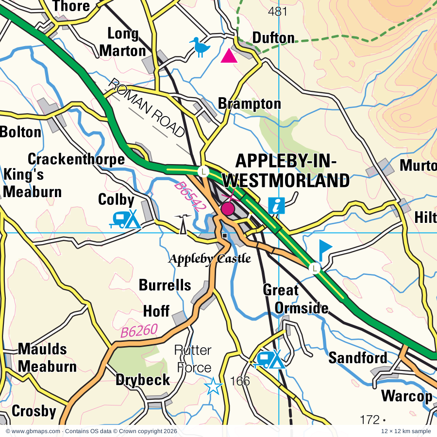
Appleby-in-Westmorland regional road map. Full 60 × 60 km PDF, SVG and Illustrator files, with a free PDF sample.

GBMAPS.COM

Appleby-in-Westmorland Regional Road Map

Call Us Now for Help01751 473136

GREAT BRITAIN ROAD ATLAS · 1:250,000 GB-360-0510

Appleby-in-Westmorland & surrounding area

Explore the full 60 × 60 km Appleby-in-Westmorland regional road map at 1:250,000, covering Kirkby Stephen, Sedbergh, Kendal, Penrith, Ambleside. Compare the complete coverage below; a detailed PDF sample is available free.

APPLEBY-IN-WESTMORLAND & SURROUNDING AREAREGIONAL ROAD MAP
60 × 60 km · Full map previewDownload the free SVG ↓

INSIDE THE FULL 60 × 60 KM MAP

Explore the Appleby-in-Westmorland map area

1:250,000 cartography

Towns, villages & places

More mapped places (194)
  • Great Asby
  • Drybeck
  • Sleagill
  • Rosgill
  • Bowderdale
  • Little Asby
  • Hoff
  • Weasdale
  • Newby
  • Burrells
  • Bampton
  • Colby
  • Morland
  • Sadgill
  • Selside
  • Grayrigg
  • Watchgate
  • Lowgill
  • Ravenstonedale
  • Crackenthorpe
  • Bolton
  • Bleatarn
  • Whale
  • Smardale
  • Hackthorpe
  • Sandford
  • Lowther
  • Soulby
  • Helton
  • Waitby
  • Cliburn
  • Kentmere
  • Brampton
  • Warcop
  • Firbank
  • Melkinthorpe
  • Little Musgrave
  • Askham
  • Hilton
  • Burneside
  • Murton
  • Staveley
  • Dufton
  • Cautley
  • Clifton
  • Nateby
  • Winton
  • Hartley
  • Howtown
  • Newbiggin
  • Martindale
  • Knock
  • Ings
  • Tirril
  • Hartsop
  • Culgaith
  • Kaber
  • Millthrop
  • Yanwath
  • Millholme
  • Milburn
  • Watermillock
  • Brough
  • Outhgill
  • Sandwick
  • Rookby
  • Helbeck
  • Crook
  • Troutbeck
  • Bridgend
  • Wreay
  • Killington
  • Oxenholme
  • Longthwaite
  • Middleshaw
  • Blencarn
  • Stainton
  • Dacre
  • Natland
  • Heggerscales
  • Patterdale
  • Underbarrow
  • Skirwith
  • Glenridding
  • Edenhall
  • Kirkland
  • Middleton
  • Hutton
  • North Stainmore
  • Brigsteer
  • Dockray
  • Rydal
  • Newbiggin
  • Langwathby
  • Clappersgate
  • Gawthrop
  • Matterdale End
  • Winster
  • Barras
  • Sedgwick
  • Crosthwaite
  • Penruddock
  • Ousby
  • Gatebeck
  • Winskill
  • Motherby
  • Garsdale
  • Dent
  • Hunsonby
  • Row
  • Endmoor
  • Storrs
  • Stainton
  • Catterlen
  • Greystoke
  • Levens
  • Salkeld Dykes
  • Little Salkeld
  • Grasmere
  • Outgate
  • Laithes
  • Hincaster
  • Troutbeck
  • Great Salkeld
  • Mansergh
  • Crooklands
  • Melmerby
  • Hawkshead
  • Barbon
  • Elterwater
  • Berrier
  • Leasgill
  • Cowgill
  • North Dykes
  • Cotterdale
  • Nook
  • Johnby
  • Deepdale
  • Heversham
  • Glassonby
  • Plumpton
  • Witherslack
  • Unthank
  • Gamblesby
  • Legburthwaite
  • Farleton
  • Lupton
  • Mill Side
  • Milnthorpe
  • Skelton
  • Keld
  • Grizedale
  • Scales
  • Ellonby
  • Witherslack
  • Mungrisdale
  • Satterthwaite
  • Thwaite
  • Thwaite Head
  • Lakeside
  • Threlkeld
  • Lamonby
  • Force Forge
  • Finsthwaite
  • Appersett
  • Storth
  • Coniston
  • Hardraw
  • Mosedale
  • Langdon Beck
  • Newby Bridge
  • Meathop
  • Ayside
  • Rusland
  • Sedbusk
  • Hawes
  • Gayle
  • Ettersgill
  • Lindale
  • Backbarrow
  • Burtersett
  • Millhouse
  • Bouth
  • Low Wood
  • Colton
  • Ireshopeburn
  • Wearhead
  • Oughtershaw
  • Greenodd
  • St John's Chapel
  • Fell Side
  • Beckermonds
  • Caldbeck
  • Arrad Foot

Roads across this sheet

M6, A6, A65, A591, A592, A593, A683, A684, A685, A686, A689, A5074, A5075, A5091, A5092, A5284, A6070, B5271, B5277, B5278, B5282, B5284, B5285, B5286

More road numbers

B5287, B5288, B5299, B5305, B5320, B5322, B5343, B5360, B6254, B6255, B6256, B6257, B6259, B6260, B6261, B6262, B6270, B6276, B6277, B6384, B6385, B6412, B6413, B6542

Rivers & waterways

Birk Beck, Black Burn, Borrow Beck, Cam Beck, Crowdundle Beck, Harwood Beck, Lancaster Canal, Leck Beck, River Brathay, River Caldew, River Eamont, River Eden

More waterways

River Gilpin, River Greta, River Kent, River Lowther, River Lune, River Lyvennet, River Petteril, River Ribble, River South Tyne, River Sprint, River Swale, River Tees, River Ure, River Wear, River Wharfe, River Winster, St John's Beck, Swindale Beck

Landmarks & landscape

Abbott Hall, K Village Heritage Centre, Museum of Lakeland Life & Industry, Acorn Bank Garden & Water Mill, Activity Centre, Aira Force, Appersett Viaduct, Appleby Castle, Aquarium of the Lakes, Arten Gill Viaduct, Beatrix Potter Gallery, Beckstones Art Gallery, Blackwell, Brantwood, LAKE DISTRICT NATIONAL PARK, YORKSHIRE DALES NATIONAL PARK

More named features

Bridge House, Brough Castle, Brougham Castle, Brougham Hall, Bullpot Farm, Butter Tubs, Castle, Catrake Force, Kisdon Force, Cauldron Snout, Cautley Spout, Cotter Force, Countess Pillar, Craft Centre, Crossbank Nature Reserve, Cumbrian Carvings, Cycle Trail, Cycle Trails, Dalemain, Dalemain Historic House and Garden, Dales Countryside Museum, Dent Head Viaduct, Dent Village Heritage Centre, Dove Cottage & Wordsworth Museum, Dufton Ghyll Wood Nature Reserve, Eden Valley Railway, Farfield Mill Arts and Heritage Centre, Fell Foot Park, Forest Hall, Fox's Pulpit, Galava Roman Fort, Graythwaite Hall Garden, Great Ashby Scar Nature Reserve, Grizedale Forest Park, Grizedale Forest (Visitor Centre), Go Ape Grizedale, Sculpture Park, Halecat House Garden, Hardraw Force, Hawkshead Courthouse, Hawkshead Grammar School, Heritage Attraction, Hervey Nature Reserve, High Force, Hill Top (Beatrix Potter's Cottage), Hilltop (Beatrix Potter's Cottage), Holehird Gardens, Holme Open Farm, Hotel, Hutton-in-the-Forest, Ingmire Hall, Kendal Museum, King Arthur's Round Table, Kirkstone Pass Inn, Lake District Visitor Centre (Brockhole), Lakeland Bird of Prey Centre, Lakeland Motor Museum, Lakeside and Haverthwaite Railway, Levens Hall, Little Salkeld Watermill, Low Sizergh Barn, Lowbridge House, Marina, Mayburgh Henge, Outward Bound Mountain School, Peel Tower, Pendragon Castle, Penrith Castle, Penrith Museum, Priests Mill, ROMAN FORT, Rheged The Village In The Hill, Rigmaden Park, Rookin House, Rutter Force, Rydal Mount, Rydale Mount, Sedbergh National Park Centre, Shap Abbey, Sizergh Castle and Gardens, Skelwith Force, Stainmore Railway, Stockghyll Force, Stott Park Bobbin Mill, Tarn Hows, The Alpaca Centre, The Armitt Library and Museum, The Hawes Rope Makers, Wensleydale Pottery, Threlkeld Quarry Museum, Townend, Uldale House, Wain Wath Force, Weardale Folk Museum, Wensleydale Creamery, The Wensleydale Cheese Experience, Hawes National Park Centre Visitor Centre, Gayle Mill, Wetheriggs Zoo & Animal Sanctuary, Winderwath Gardens, World of Beatrix Potter, Wray Castle
Local authority & parish coverage

Wholly or partly within the full map rectangle. These boundaries are coverage information, not additional artwork layers.

  • County DurhamPartly within
  • CumberlandPartly within
  • Lancaster DistrictPartly within
  • North YorkshirePartly within
  • Westmorland and FurnessPartly within
Wards & electoral divisions 34 areas
  • Alston and Fellside Ward (part)
  • Appleby and Brough Ward
  • Bothel and Wharrels Ward (part)
  • Bowness and Lyth Ward (part)
  • Burton and Holme Ward (part)
  • Coniston and Hawkshead Ward (part)
  • Eamont and Shap Ward
  • Eden and Lyvennet Vale Ward
  • Grange and Cartmel Ward (part)
  • Greystoke and Ullswater Ward (part)
  • Hesket and Lazonby Ward (part)
  • High Furness Ward (part)
  • Kendal Castle Ward
  • Kendal Highgate Ward
  • Kendal Nether Ward
  • Kendal South Ward
  • Kendal Strickland and Fell Ward
  • Kent Estuary Ward (part)
  • Keswick Ward (part)
  • Kirkby Stephen and Tebay Ward
  • Levens and Crooklands Ward
  • Penrith North Ward
  • Penrith South Ward
  • Sedbergh and Kirkby Lonsdale Ward (part)
  • Thursby Ward (part)
  • Upper Kent Ward
  • Upper Lune Valley Ward (part)
  • Windermere and Ambleside Ward (part)
  • Bentham & Ingleton ED (part)
  • Settle & Penyghent ED (part)
  • Upper Dales ED (part)
  • Upper Teesdale ED (part)
  • Weardale ED (part)
  • Wharfedale ED (part)
Civil parishes & communities 160 areas
  • Alston Moor CP (part)
  • Appleby-in-Westmorland CP
  • Asby CP
  • Askham CP
  • Bainbridge CP (part)
  • Bampton CP
  • Barbon CP
  • Barton and Pooley Bridge CP
  • Beetham CP (part)
  • Bolton CP
  • Bowes CP (part)
  • Brough CP
  • Brough Sowerby CP
  • Brougham CP
  • Broughton East CP (part)
  • Buckden CP (part)
  • Caldbeck CP (part)
  • Cartmel Fell CP
  • Casterton CP (part)
  • Castle Sowerby CP (part)
  • Catterlen CP
  • Claife CP
  • Cliburn CP
  • Clifton CP
  • Colby CP
  • Colton CP (part)
  • Coniston CP (part)
  • Cotherstone CP (part)
  • Crackenthorpe CP
  • Crook CP
  • Crosby Garrett CP
  • Crosby Ravensworth CP
  • Crosthwaite and Lyth CP
  • Culgaith CP
  • Dacre CP
  • Dent CP
  • Docker CP
  • Dufton CP
  • Egton with Newland CP (part)
  • Firbank CP
  • Forest and Frith CP (part)
  • Garsdale CP
  • Glassonby CP (part)
  • Grange-Over-Sands CP (part)
  • Grayrigg CP
  • Great Salkeld CP
  • Great Strickland CP
  • Greystoke CP
  • Hartley CP
  • Haverthwaite CP
  • Hawes CP (part)
  • Hawkshead CP
  • Helbeck CP
  • Helsington CP
  • Hesket CP (part)
  • Heversham CP
  • High Abbotside CP (part)
  • Hincaster CP
  • Hoff CP
  • Holme CP (part)
  • Holwick CP (part)
  • Horton in Ribblesdale CP (part)
  • Hugill CP
  • Hunderthwaite CP (part)
  • Hunsonby CP
  • Hutton CP
  • Hutton Roof CP (part)
  • Ingleton CP (part)
  • Kaber CP
  • Kendal CP
  • Kentmere CP
  • Killington CP
  • King's Meaburn CP
  • Kirkby Lonsdale CP (part)
  • Kirkby Stephen CP
  • Kirkby Thore CP
  • Kirkoswald CP (part)
  • Lakes CP (part)
  • Lambrigg CP
  • Langwathby CP
  • Lartington CP (part)
  • Lazonby CP (part)
  • Leck CP (part)
  • Levens CP
  • Lindale and Newton-in-Cartmel CP (part)
  • Little Strickland CP
  • Long Marton CP
  • Longsleddale CP
  • Low Abbotside CP (part)
  • Lower Allithwaite CP (part)
  • Lowick CP (part)
  • Lowther CP
  • Lunedale CP (part)
  • Lupton CP (part)
  • Mallerstang CP
  • Mansergh CP
  • Martindale CP
  • Matterdale CP
  • Melmerby CP (part)
  • Mickleton CP (part)
  • Middleton CP
  • Milburn CP
  • Milnthorpe CP
  • Morland CP
  • Muker CP (part)
  • Mungrisdale CP (part)
  • Murton CP
  • Musgrave CP
  • Nateby CP
  • Natland CP
  • Nether Staveley CP
  • New Hutton CP
  • Newbiggin CP
  • Newbiggin CP (part)
  • Newby CP
  • Old Hutton and Holmescales CP
  • Ormside CP
  • Orton CP
  • Ousby CP (part)
  • Over Staveley CP
  • Patterdale CP
  • Penrith CP
  • Preston Patrick CP
  • Preston Richard CP
  • Ravenstonedale CP
  • Satterthwaite CP
  • Sebergham CP (part)
  • Sedbergh CP
  • Sedgwick CP
  • Selside and Fawcett Forest CP
  • Shap CP
  • Shap Rural CP
  • Skelsmergh and Scalthwaiterigg CP
  • Skelton CP (part)
  • Skelwith CP
  • Sleagill CP
  • Sockbridge and Tirril CP
  • Soulby CP
  • St. John's Castlerigg and Wythburn CP (part)
  • Stainmore CP
  • Stainton CP
  • Stanhope CP (part)
  • Staveley-in-Cartmel CP
  • Strickland Ketel CP
  • Strickland Roger CP
  • Tebay CP
  • Temple Sowerby CP
  • Thornton in Lonsdale CP (part)
  • Threlkeld CP (part)
  • Torver CP (part)
  • Underbarrow and Bradleyfield CP
  • Underskiddaw CP (part)
  • Waitby CP
  • Warcop CP
  • Wharton CP
  • Whinfell CP
  • Windermere and Bowness CP
  • Winton CP
  • Witherslack, Meathop and Ulpha CP (part)
  • Yanwath and Eamont Bridge CP

Source: the GBMaps road atlas, OS Boundary-Line and postcode mapping datasets. Source editions are being checked for publication. Unmarked boundary names are wholly within the sheet; “part” means the map edge crosses the area.

Place lists are selected from the map source, not a complete gazetteer. Named features describe the cartography; visitor facilities and opening status are not verified. The free sample covers only 12 × 12 km of this larger sheet.

INSIDE YOUR DOWNLOAD

A proper road map, in useful formats

Road classifications, towns and villages, railways, rivers, landscape detail and tourist symbols, brought together in the GBMaps regional road atlas style.

PDF filePDFSVG fileSVGAdobe Illustrator AI fileAi

PDF for the finished map. SVG and layered Illustrator artwork for adapting colours, adding your own information and preparing designs.

THE FINISHED SHEET

Designed for print and presentation

Map coverage
60 × 60 km
Sample coverage
12 × 12 km
Print layout
A3 landscape · enlarged 1:250k cartography
Sheet furniture
Border, scale bar, key & north arrow

A few useful details

What changes when I select another square?

Select a surrounding square to bring it into the centre and reveal the maps around it. Each square is a different 60 × 60 km map. The preview, free sample and selected download change together. Neighbouring sheets overlap by 30 km so you can choose the coverage that suits you.

Is the free sample a vector map?

The on-page detail is an SVG. The free download is a separate 12 × 12 km PDF with a link to the full map. Please retain its copyright credits and product link when sharing it.

Can I buy a larger combined map?

These downloads are individual ready-made sheets. Contact GBMaps if you need a larger combined area.

FREE PDF SAMPLE

Your free map sample

Your free 12 × 12 km sample includes a link back to this map, so you can return for the full area whenever you need it.

Download free PDF sample ↓

Get your Appleby-in-Westmorland map

Map download bundle

£24.00including VATOne payment

Pay securely

One payment. Your map stays open.

Your map download

Your map files

Preparing your download…

Checking your private download link…

Your map downloads

Already bought a map?

Find the downloads from your purchases.

Enter the email address you used at checkout. We’ll email you a private link to your available map downloads.