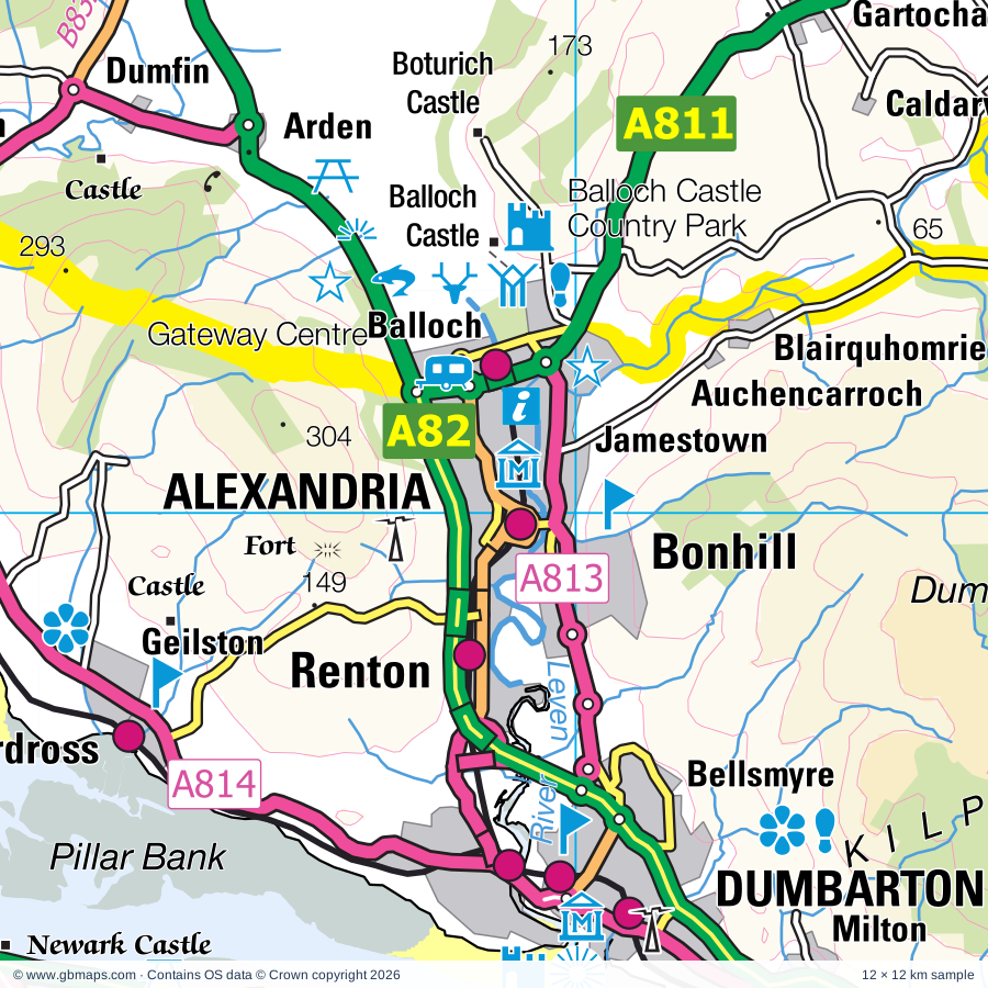
Alexandria regional road map. Full 60 × 60 km PDF, SVG and Illustrator files, with a free PDF sample.

GBMAPS.COM

Alexandria Regional Road Map

Call Us Now for Help01751 473136

GREAT BRITAIN ROAD ATLAS · 1:250,000 GB-240-0690

Alexandria & surrounding area

Explore the full 60 × 60 km Alexandria regional road map at 1:250,000, covering Glasgow, Alexandria, Port Glasgow, Greenock, Erskine. Compare the complete coverage below; a detailed PDF sample is available free.

ALEXANDRIA & SURROUNDING AREAREGIONAL ROAD MAP
60 × 60 km · Full map previewDownload the free SVG ↓

INSIDE THE FULL 60 × 60 KM MAP

Explore the Alexandria map area

1:250,000 cartography

Towns, villages & places

More mapped places (99)

Roads across this sheet

M8, M73, M74, M77, M80, M898, A8, A74, A77, A80, A81, A82, A89, A721, A724, A726, A728, A730, A736, A739, A741, A749, A752, A761

More road numbers

A763, A770, A771, A803, A804, A806, A807, A808, A809, A810, A811, A812, A813, A814, A815, A817, A818, A819, A821, A844, A873, A875, A877, A879, A880, A885, A891, A8014, B756, B757, B758, B759, B762, B763, B765, B766, B767, B768, B769, B771, B774, B775, B776, B786, B787, B788, B789, B790, B791, B804, B806, B808, B812, B814, B815, B818, B819, B821, B822, B826, B828, B829, B830, B832, B833, B834, B835, B836, B837, B838, B839, B857, B858, B872, B883, B7001, B7050, B7054, B7058, B7071, B8023, B8030, B8031, B8032, B8034, B8037, B8041, B8042, B8048, B8049, B8050, B8055

Rivers & waterways

Achray Water, Allt Arnan, Allt Gleann nam Meann, Allt Strath a' Ghlinne, Allt na Lairige, Annet Burn, Ardyne Burn, Ben Glas Burn, Black Cart Water, Black Water, Blane Water, Brannie Burn

More waterways

Calair Burn, Dubh Eas, Duchray Water, Eas Gobhain, Endrick Water, Finlas Water, Forth & Clyde Canal, Forth & Clyde Canal (Glasgow Branch), Forth and Clyde Canal (Glasgow Branch), Garbh Uisge, Goodie Water, Gryfe Water, Inveruglas Water, Keltie Water, Kelty Water, Kilblaan Burn, Locher Water, Noddsdale Water, North Calder Water, River Balvag, River Calder, River Carron, River Clyde, River Falloch, River Forth, River Fyne, River Garnock, River Gryfe, River Kelvin, River Leven, River Shira, River Teith, Water of Ruchill, White Cart Water

Landmarks & landscape

Ardencraig Garden, Ardkinglas Woodland Garden, Ascog Hall Fernery and Garden, Auchentoshan Distillery, Auld Kirk, Barony Chambers Museum, Ballikinrain Castle, Balloch Castle, Balloch Castle Country Park, Barochan Cross, Barochan House, Bearsden Bath House, Benmore Botanic Garden, LOCH LOMOND & THE TROSSACHS NATIONAL PARK

More named features

Boturich Castle, Bracklinn Falls, Broch, Burrell Collection, Campsie Outdoor Centre, Cardross, Carrick Castle, Carruth House, Castle, Castle Semple Collegiate Church, Clachan Farm, Visitor Centre, Clachan of Campsie Craft Centre, Clydebank Museum, Coats Observatory, Cornalees Bridge Visitor Centre, Cowal Bird Garden and Farm Park, Craigend Visitor Centre, Crookston Castle, Culcreuch Castle, Cycle Trail, Cycle Trails, Daldowie Doocot, David Marshall Lodge Visitor Centre, Scottish Wool Centre, Trossachs Discovery Centre, Denny Ship Model Experiment Tank, Dumbarton Castle, Dunderave Castle, Dunoon and Cowal Heritage Trust, Duntreath Castle, Finlaystone Country Estate, Fyne Ales Brewery Visitor Centre, Gallery of Modern Art, The McLellan Galleries, Glasgow Sch of Art, The Lighthouse, Gartmore House, Gateway Visitor Centre, Geilston Garden, Glasgow Botanic Gardens, Glasgow Cathedral, St Andrew's Cathedral, Glasgow Science Centre, Gleddoch House (Equestrian Venue), Glenarn Garden, Glenfyne Lodge, Glengoyne Distillery, Glengoyne Distillery, Visitor Centre, Gleniffer Braes Country Park, Go Ape Aberfoyle, Hamilton Toy Collection, Hampden Park Football Stadium, Hotel, House for an Art Lover, Inchmahome Priory, Inverbeg Gallery, Inversnaid Nature Reserve, Isle of Bute Discovery Centre, Kilmun Arboretum, Knock Castle, Largs Museum, Largs Old Kirk, Lillie Art Gallery, Loch Ardinning, Loch Lomond & Trossachs National Park HQ Visitor Centre, Loch Lomond Bird of Prey Centre, Loch Lomond National Nature Reserve, Loch Lomond Sea Life Centre, Loup of Fintry Waterfall, Luss Visitor Centre, McLean Museum and Art Gallery, Motoring Heritage Centre, Mugdock Country Park, Muirshiel Country Park, Muirshiel Country Park Visitor Centre, Museum of Piping, Riverside, The Glasgow Police Museum, Museum of Transport, Kelvingrove Museum and Art Gallery, Hunterian Museum, Riverside Museum, Newark Castle, Old Leckie, Ornamental Drive, Overtoun House, Paisley Abbey, Paisley Arts Centre, Paisley Museum & Art Gallery, Sma'Shot Cottages, Peoples Palace, Scottish National Science Museum, Royal Highland Fusiliers, St Mungo Museum of Religious Life & Art, Pinkston Water Sports Centre, Pollok Country Park, Pollok House, Provan Hall, Provan Hall in Auchinlea Park, Provand's Lordship, Trades Hall, Ptarmigan Lodge, Renfrew Museum, Rob Roy's House, Ross Priory, Rossdhu House, Rothesay Castle, Rowardennan Lodge, Skelmorlie Castle, Soar, St Lukes Cathedral, St Mary's Cathedral, St Mary's Chapel, St Modan's Well, Strachur Smiddy, The Bute Museum, The Hill House, The Tall Ship, The Tenement House, The Whangie, Titan Clydebank Visitor Centre, Vikingar Visitor Centre, Weaver's Cottage, Wild Animal Attraction(Deer,reindeer,seal,monkey etc.
Local authority & parish coverage

Wholly or partly within the full map rectangle. These boundaries are coverage information, not additional artwork layers.

  • Argyll and ButePartly within
  • East DunbartonshirePartly within
  • East RenfrewshirePartly within
  • Glasgow CityPartly within
  • InverclydeWholly within
  • North AyrshirePartly within
  • North LanarkshirePartly within
  • Perth and KinrossPartly within
  • RenfrewshirePartly within
  • South LanarkshirePartly within
  • StirlingPartly within
  • West DunbartonshireWholly within
Wards & electoral divisions 83 areas
  • Anderston/City/Yorkhill Ward
  • Baillieston Ward (part)
  • Barrhead, Liboside and Uplawmoor Ward (part)
  • Bearsden North Ward
  • Bearsden South Ward
  • Bishopbriggs North and Campsie Ward
  • Bishopbriggs South Ward
  • Bishopton, Bridge of Weir and Langbank Ward
  • Blantyre Ward (part)
  • Bothwell and Uddingston Ward (part)
  • Calton Ward
  • Cambuslang East Ward (part)
  • Cambuslang West Ward (part)
  • Canal Ward
  • Cardonald Ward
  • Clydebank Central Ward
  • Clydebank Waterfront Ward
  • Coatbridge North Ward (part)
  • Coatbridge West Ward (part)
  • Cowal Ward (part)
  • Dennistoun Ward
  • Drumchapel/Anniesland Ward
  • Dumbarton Ward
  • Dunoon Ward (part)
  • East Centre Ward
  • Erskine and Inchinnan Ward
  • Forth and Endrick Ward (part)
  • Garnock Valley Ward (part)
  • Garscadden/Scotstounhill Ward
  • Gartcosh, Glenboig and Moodiesburn Ward (part)
  • Giffnock and Thornliebank Ward (part)
  • Govan Ward
  • Greater Pollok Ward (part)
  • Helensburgh Central Ward
  • Helensburgh and Lomond South Ward
  • Hillhead Ward
  • Houston, Crosslee and Linwood Ward
  • Inverclyde Central Ward
  • Inverclyde East Central Ward
  • Inverclyde East Ward
  • Inverclyde North Ward
  • Inverclyde South Ward
  • Inverclyde South West Ward
  • Inverclyde West Ward
  • Isle of Bute Ward (part)
  • Johnstone North, Kilbarchan, Howwood and Lochwinnoch Ward (part)
  • Johnstone South and Elderslie Ward (part)
  • Kilpatrick Ward
  • Kilsyth Ward (part)
  • Kirkintilloch East and North and Twechar Ward (part)
  • Langside Ward
  • Lenzie and Kirkintilloch South Ward
  • Leven Ward
  • Linn Ward (part)
  • Lomond North Ward
  • Lomond Ward
  • Maryhill Ward
  • Mid Argyll Ward (part)
  • Milngavie Ward
  • Newlands/Auldburn Ward (part)
  • North Coast Ward (part)
  • North East Ward (part)
  • Oban North and Lorn Ward (part)
  • Paisley East and Central Ward
  • Paisley Northeast and Ralston Ward
  • Paisley Northwest Ward
  • Paisley Southeast Ward (part)
  • Paisley Southwest Ward (part)
  • Partick East/Kelvindale Ward
  • Pollokshields Ward
  • Renfrew North and Braehead Ward
  • Renfrew South and Gallowhill Ward
  • Rutherglen Central and North Ward
  • Rutherglen South Ward (part)
  • Shettleston Ward
  • Southside Central Ward
  • Springburn/Robroyston Ward
  • Stepps, Chryston and Muirhead Ward
  • Stirling West Ward (part)
  • Strathearn Ward (part)
  • Thorniewood Ward (part)
  • Trossachs and Teith Ward (part)
  • Victoria Park Ward
Civil parishes & communities 0 areas

    Source: the GBMaps road atlas, OS Boundary-Line and postcode mapping datasets. Source editions are being checked for publication. Unmarked boundary names are wholly within the sheet; “part” means the map edge crosses the area.

    Place lists are selected from the map source, not a complete gazetteer. Named features describe the cartography; visitor facilities and opening status are not verified. The free sample covers only 12 × 12 km of this larger sheet.

    INSIDE YOUR DOWNLOAD

    A proper road map, in useful formats

    Road classifications, towns and villages, railways, rivers, landscape detail and tourist symbols, brought together in the GBMaps regional road atlas style.

    PDF filePDFSVG fileSVGAdobe Illustrator AI fileAi

    PDF for the finished map. SVG and layered Illustrator artwork for adapting colours, adding your own information and preparing designs.

    THE FINISHED SHEET

    Designed for print and presentation

    Map coverage
    60 × 60 km
    Sample coverage
    12 × 12 km
    Print layout
    A3 landscape · enlarged 1:250k cartography
    Sheet furniture
    Border, scale bar, key & north arrow

    A few useful details

    What changes when I select another square?

    Select a surrounding square to bring it into the centre and reveal the maps around it. Each square is a different 60 × 60 km map. The preview, free sample and selected download change together. Neighbouring sheets overlap by 30 km so you can choose the coverage that suits you.

    Is the free sample a vector map?

    The on-page detail is an SVG. The free download is a separate 12 × 12 km PDF with a link to the full map. Please retain its copyright credits and product link when sharing it.

    Can I buy a larger combined map?

    These downloads are individual ready-made sheets. Contact GBMaps if you need a larger combined area.

    FREE PDF SAMPLE

    Your free map sample

    Your free 12 × 12 km sample includes a link back to this map, so you can return for the full area whenever you need it.

    Download free PDF sample ↓

    Get your Alexandria map

    Map download bundle

    £24.00including VATOne payment

    Pay securely

    One payment. Your map stays open.

    Your map download

    Your map files

    Preparing your download…

    Checking your private download link…

    Your map downloads

    Already bought a map?

    Find the downloads from your purchases.

    Enter the email address you used at checkout. We’ll email you a private link to your available map downloads.