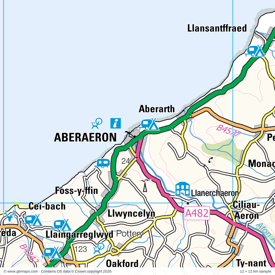
Explore the full 60 × 60 km Aberaeron regional road map at 1:250,000, covering Aberaeron, Aberystwyth, Lampeter, Llanybydder, Tregaron. Compare the complete coverage below; a detailed PDF sample is available free.
Afon Aeron, Afon Cothi, Afon Dyfi / River Dovey, Afon Leri, Afon Rheidol, Afon Teifi, Afon Twrch, Afon Ystwyth
Landmarks & landscape
Aberystwyth Castle, Borth Animalarium, Cae-Hir Gardens, Camera Obscura, Aberystwyth Electric Cliff Railway, Cardigan Bay Marine Wildlife Centre, Cardigan Heritage Centre, Cardigan Island Coastal Farm Park, Castell Newydd Emlyn Castle, Cilgerran Castle, Cors Caron National Nature Reserve, Craft Centre, Crochendy Llanarth Pottery, PEMBROKESHIRE COAST NATIONAL PARK, SNOWDONIA NATIONAL PARK
More named features
Curlew Weavers Woollen Mill, Dolaucothi Gold Mines, Dyffryn Ardudwy Burial Chamber, Dyfi Furnace, Dyfi National Nature Reserve, Fantasy Farm Park, Internal Fire Museum of Power, Llanerchaeron, National Coracle Centre, National Library of Wales, Ceredigion Museum, Llanbadarn Church, New Quay Heritage Centre, New Quay Honey Farm, Norwood Gardens, Old Smithy Craftshop & Heritage Centre, Old Warren Hill Nature Reserve, Rock Mill, St Dogmaels Abbey, Teifi Valley Railway, The Narrow Gauge Railway Museum, Tregaron Kite Centre, Visitor Centre, Welsh Wildlife Centre, Y Felin (Water Mill), Ynys-Hir Nature Reserve
Wholly or partly within the full map rectangle. These boundaries are coverage information, not additional artwork layers.
Gwynedd - GwyneddPartly within
Powys - PowysPartly within
Sir Benfro - PembrokeshirePartly within
Sir Ceredigion - CeredigionPartly within
Sir Gaerfyrddin - CarmarthenshirePartly within
Wards & electoral divisions 46 areas
Aberaeron and Aberarth ED
Aberdyfi ED (part)
Aberporth and Y Ferwig ED
Aberystwyth Morfa a Glais ED
Aberystwyth Penparcau ED
Aberystwyth Rheidol ED
Beulah and Llangoedmor ED
Boncath and Clydau ED (part)
Borth ED
Bro Dysynni ED (part)
Cenarth and Llangeler ED (part)
Ceulan a Maesmawr ED (part)
Cilgerran and Eglwyswrw ED (part)
Ciliau Aeron ED
Cilycwm ED (part)
Faenor ED
Glantwymyn ED (part)
Gorllewin Tywyn ED (part)
Lampeter ED
Llanbadarn Fawr ED
Llandyfriog ED (part)
Llandysilio and Llangrannog ED
Llandysul North and Troedyraur ED
Llandysul South ED
Llanfarian ED
Llanfihangel Ystrad ED
Llanfihangel-ar-Arth ED (part)
Llangeitho ED (part)
Llangybi ED
Llannarth ED
Llanrhystyd ED
Llansanffraid ED
Llanwenog ED
Llanybydder ED (part)
Lledrod ED (part)
Manordeilo and Salem ED (part)
Melindwr ED (part)
Mwldan ED
New Quay and Llanllwchaearn ED
Penbryn ED
St. Dogmaels ED (part)
Teifi ED
Tirymynach ED
Trefeurig ED (part)
Tregaron and Ystrad Fflur ED (part)
Ystwyth ED (part)
Civil parishes & communities 70 areas
Aberaeron Community
Aberdovey Community
Aberporth Community
Aberystwyth Community
Beulah Community
Boncath Community (part)
Borth Community
Bryn-Crug Community (part)
Cadfarch Community (part)
Cardigan Community
Cenarth Community (part)
Ceulanamaesmawr Community (part)
Cilgerran Community (part)
Ciliau Aeron Community
Cilycwm Community (part)
Cynwyl Gaeo Community (part)
Dyffryn Arth Community
Eglwyswrw Community (part)
Faenor Community
Geneu'r Glyn Community
Henfynyw Community
Lampeter Community
Llanarth Community
Llanbadarn Fawr Community
Llanddewi Brefi Community (part)
Llandyfriog Community (part)
Llandysiliogogo Community
Llandysul Community
Llanfair Clydogau Community
Llanfarian Community
Llanfihangel Ystrad Community
Llanfihangel-ar-Arth Community (part)
Llangeitho Community
Llangeler Community (part)
Llangoedmor Community
Llangrannog Community
Llangwyryfon Community
Llangybi Community
Llangynfelyn Community (part)
Llanilar Community
Llanllwchaiarn Community
Llanllwni Community (part)
Llanrhystyd Community
Llansantffraed Community
Llansawel Community (part)
Llanwenog Community
Llanwnnen Community
Llanybydder Community (part)
Llanycrwys Community
Lledrod Community
Manordeifi Community (part)
Melindwr Community (part)
Nantcwnlle Community
Nevern Community (part)
New Quay Community
Newcastle Emlyn Community (part)
Penbryn Community
Pencarreg Community (part)
Pennal Community (part)
St. Dogmaels Community
Tirymynach Community
Trawsgoed Community (part)
Trefeurig Community (part)
Tregaron Community (part)
Troedyraur Community
Tywyn Community (part)
Y Ferwig Community
Ysgubor-y-Coed Community (part)
Ystrad Fflur Community (part)
Ystrad Meurig Community (part)
Source: the GBMaps road atlas, OS Boundary-Line and postcode mapping datasets. Source editions are being checked for publication. Unmarked boundary names are wholly within the sheet; “part” means the map edge crosses the area.
INSIDE YOUR DOWNLOAD
A proper road map, in useful formats
Road classifications, towns and villages, railways, rivers, landscape detail and tourist symbols, brought together in the GBMaps regional road atlas style.
PDF for the finished map. SVG and layered Illustrator artwork for adapting colours, adding your own information and preparing designs.
THE FINISHED SHEET
Designed for print and presentation
Map coverage
60 × 60 km
Sample coverage
12 × 12 km
Print layout
A3 landscape · enlarged 1:250k cartography
Sheet furniture
Border, scale bar, key & north arrow
A few useful details
What changes when I select another square?
Select a surrounding square to bring it into the centre and reveal the maps around it. Each square is a different 60 × 60 km map. The preview, free sample and selected download change together. Neighbouring sheets overlap by 30 km so you can choose the coverage that suits you.
Is the free sample a vector map?
The on-page detail is an SVG. The free download is a separate 12 × 12 km PDF with a link to the full map. Please retain its copyright credits and product link when sharing it.
Can I buy a larger combined map?
These downloads are individual ready-made sheets. Contact GBMaps if you need a larger combined area.