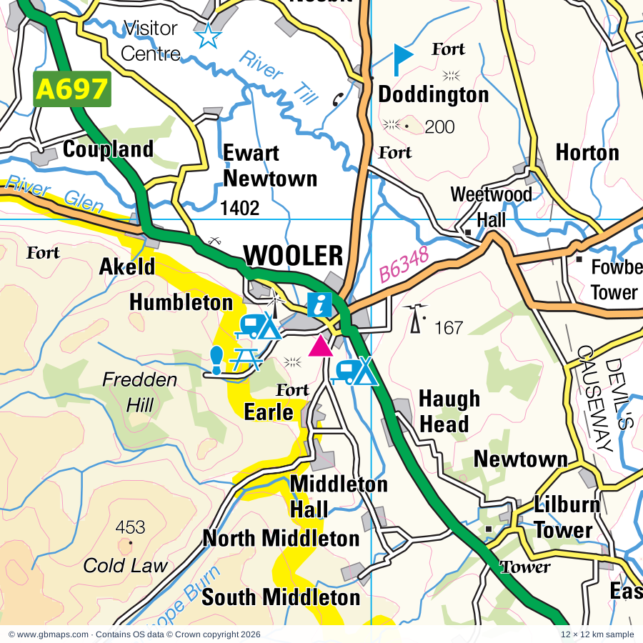
Wooler regional road map. Full 60 × 60 km PDF, SVG and Illustrator files, with a free PDF sample.

GBMAPS.COM

Wooler Regional Road Map

Call Us Now for Help01751 473136

GREAT BRITAIN ROAD ATLAS · 1:250,000 GB-390-0630

Wooler & surrounding area

Explore the full 60 × 60 km Wooler regional road map at 1:250,000, covering Wooler, Coldstream, Kelso, Duns, Jedburgh. Compare the complete coverage below; a detailed PDF sample is available free.

WOOLER & SURROUNDING AREAREGIONAL ROAD MAP
60 × 60 km · Full map previewDownload the free SVG ↓

INSIDE THE FULL 60 × 60 KM MAP

Explore the Wooler map area

1:250,000 cartography

Towns, villages & places

More mapped places (148)
  • Ford
  • Nesbit
  • Etal
  • Doddington
  • Sourhope
  • Wark
  • North Middleton
  • Lempitlaw
  • South Middleton
  • Lennel
  • Duddo
  • Carham
  • Linton
  • Morebattle
  • Ilderton
  • Birgham
  • Bowsden
  • Grindon
  • Newtown
  • Lowick
  • Linhope
  • Sprouston
  • Howgate
  • Holburn
  • Chatton
  • Roddam
  • Hownam
  • Chillingham
  • Upsettlington
  • Shoreswood
  • Berrington
  • Wooperton
  • Norham
  • Shoresdean
  • Ednam
  • Ladykirk
  • Cessford
  • Eccles
  • Leitholm
  • Swintonmill
  • Ingram
  • Ancroft
  • Thornton
  • Swinton
  • Old Bewick
  • Heiton
  • Brandon
  • Fenwick
  • Haggerston
  • Eckford
  • Horndean
  • West Mains
  • Detchant
  • Roxburgh
  • Horncliffe
  • Branton
  • Stichill
  • Powburn
  • Warenton
  • Beal
  • Whitsome
  • Middleton
  • Cheswick
  • Loanend
  • Fishwick
  • Belford
  • Alnham
  • Beanley
  • Crailing
  • Goswick
  • Scremerston
  • Scrainwood
  • Bellshill
  • Hume
  • Biddlestone
  • Elwick
  • Easington
  • Fogo
  • Blackadder
  • Glanton
  • Nisbet
  • Eglingham
  • Makerstoun
  • Oxnam
  • Paxton
  • Nenthorn
  • Warenford
  • Alwinton
  • Hutton
  • Netherton
  • Ross
  • Whittingham
  • Allanton
  • Greenlaw
  • Burradon
  • Bonjedward
  • Lucker
  • Polwarth
  • Callaly
  • Harbottle
  • Gavinton
  • Foulden
  • Smailholm
  • Bolton
  • Edrom
  • Chirnside
  • Sharperton
  • Chirnsidebridge
  • Mossburnford
  • Brownieside
  • Ellingham
  • Newham
  • Camptown
  • Ancrum
  • North Charlton
  • Holystone
  • Lamberton
  • Burton
  • Abberwick
  • Bamburgh
  • Gordon
  • Maxton
  • Chathill
  • Clintmains
  • Cartington
  • Preston
  • Lanton
  • Flotterton
  • West Fleetham
  • Snitter
  • Preston
  • Edlingham
  • Byrness
  • Hepple
  • Thropton
  • Huntlywood
  • Newtown
  • Houndslow
  • Whitton
  • Chesters
  • Westruther
  • Abbotrule
  • Southdean
  • Longformacus
  • Shilbottle
  • Longframlington
  • Swarland
  • Felton

Roads across this sheet

A68, A697, A698, A699, A1068, A1167, A6088, A6089, A6090, A6105, A6112, B1340, B1341, B1342, B6341, B6342, B6344, B6345, B6346, B6347, B6348, B6349, B6350, B6351

More road numbers

B6352, B6353, B6354, B6355, B6356, B6357, B6358, B6364, B6365, B6396, B6397, B6400, B6401, B6404, B6435, B6436, B6437, B6438, B6456, B6460, B6461, B6470, B6525

Rivers & waterways

Ale Water, Blackadder Water, Bowmont Water, College Burn, Dye Water, Eden Water, Harthope Burn, Jed Water, Kale Water, Leet Water, Oxnam Water, River Aln

More waterways

River Alwin, River Breamish, River Coquet, River Glen, River Rede, River Teviot, River Till, River Tweed, Usway Burn, Whiteadder Water, Wooler Water

Landmarks & landscape

Alnwick Abbey, Alnwick Castle, Bailiffgate Museum, Fusiliers Museum of Northumberland, Bamburgh Castle, Barmoor Country Park, Barrow Mill, Bemersyde Moss Nature Reserve, Berwick Castle and Ramparts, Berwick-upon-Tweed Barracks, Berwick-upon-Tweed Main Guard, Budle Bay Nature Reserve, Cairn, NORTHUMBERLAND NATIONAL PARK

More named features

Cairns, Castle, Castle Heaton, Cell Block Museum, Chain Bridge Honey Farm, Chillingham Castle, Chillingham Castle and Gardens, Chillingham Wild Cattle Park, Clark Memorial Trophy Room Museum, Cocklawburn Dunes Nature Reserve, College Valley, Cragside, Cragside Garden, Duns Castle, Duns Castle Nature Reserve, Edlingham Castle, Edrom Church, Errol Hunt Smithy, Etal Castle, Ferniehirst Castle, Floors Castle, Floors Castle and Gardens, Foulden Tithe Barn, Fowberry Tower, Greenknowe Tower, Harbottle Castle, Harestanes Visitor Centre, Heatherslaw Light Railway, Heatherslaw Mill, Hirsel Museum, Coldstream Museum, House of Hardy, Hume Castle, Jedburgh Abbey & Visitor Centre, Jedburgh Castle Jail Museum, Mary Queen of Scots' House and Visitor Centre, Kelso Abbey, Kelso Racecourse, Lady's Well, Lemmington Hall, Lime Kiln, Lindisfarne Castle, Lindisfarne Castle Garden, Lindisfarne Heritage Centre, Lindisfarne NCC Reserve, Lindisfarne Priory, Longridge Towers, Lorbottle Hall, Manderston House, Mellerstain House, Mertoun Gardens, Monteviot House Garden, Newham Hall, Norham Castle, Norham Railway Station Museum, North Charlton Rural Life Museum, Pallinsburn House, Paxton House, Pot-a-doodle-do, Preston Tower, Priory, Purves Hall, ROMAN CAMPS, Shire Pottery, Smailholm Tower, St Aidans Winery, The Alnwick Garden, The Fenton Centre, The Hirsel Country Park, The RNLI Grace Darling Museum, The Teviot, Tosson Lime Kiln, Tosson Tower, Tower, Weetwood Hall, Whitehouse Riding School, Woodhouses Bastle
Local authority & parish coverage

Wholly or partly within the full map rectangle. These boundaries are coverage information, not additional artwork layers.

  • East LothianPartly within
  • NorthumberlandPartly within
  • Scottish BordersPartly within
Wards & electoral divisions 22 areas
  • East Berwickshire Ward (part)
  • Haddington and Lammermuir Ward (part)
  • Hawick and Denholm Ward (part)
  • Hawick and Hermitage Ward (part)
  • Jedburgh and District Ward (part)
  • Kelso and District Ward
  • Leaderdale and Melrose Ward (part)
  • Mid Berwickshire Ward (part)
  • Alnwick Castle ED (part)
  • Alnwick Hotspur ED
  • Amble West with Warkworth ED (part)
  • Bamburgh ED (part)
  • Bellingham ED (part)
  • Berwick East ED
  • Berwick North ED
  • Berwick West with Ord ED
  • Longhorsley ED (part)
  • Longhoughton ED (part)
  • Norham & Islandshires ED
  • Rothbury ED (part)
  • Shilbottle ED (part)
  • Wooler ED
Civil parishes & communities 67 areas
  • Acklington CP (part)
  • Adderstone with Lucker CP
  • Akeld CP
  • Alnham CP
  • Alnwick CP (part)
  • Alwinton CP
  • Ancroft CP
  • Bamburgh CP (part)
  • Beadnell CP (part)
  • Belford CP
  • Berwick-upon-Tweed CP
  • Bewick CP
  • Biddlestone CP
  • Bowsden CP
  • Branxton CP
  • Brinkburn CP (part)
  • Callaly CP
  • Carham CP
  • Chatton CP
  • Chillingham CP
  • Cornhill-on-Tweed CP
  • Denwick CP (DET) (part)
  • Doddington CP
  • Duddo CP
  • Earle CP
  • Edlingham CP
  • Eglingham CP
  • Ellingham CP
  • Ewart CP
  • Felton CP (part)
  • Ford CP
  • Glanton CP
  • Harbottle CP (part)
  • Hedgeley CP
  • Hepple CP (part)
  • Holy Island CP
  • Horncliffe CP
  • Ilderton CP
  • Ingram CP
  • Kielder CP (part)
  • Kilham CP
  • Kirknewton CP
  • Kyloe CP
  • Lilburn CP
  • Longframlington CP (part)
  • Lowick CP
  • Middleton CP
  • Milfield CP
  • Netherton CP
  • Newton-by-the-Sea CP (part)
  • Newton-on-the-Moor and Swarland CP (part)
  • Norham CP
  • North Sunderland CP (part)
  • Ord CP
  • Otterburn CP (part)
  • Rennington CP (part)
  • Rochester CP (part)
  • Roddam CP
  • Rothbury CP (part)
  • Shilbottle CP (part)
  • Shoreswood CP
  • Snitter CP
  • Thirston CP (part)
  • Thropton CP
  • Whittingham CP
  • Whitton and Tosson CP (part)
  • Wooler CP

Source: the GBMaps road atlas, OS Boundary-Line and postcode mapping datasets. Source editions are being checked for publication. Unmarked boundary names are wholly within the sheet; “part” means the map edge crosses the area.

Place lists are selected from the map source, not a complete gazetteer. Named features describe the cartography; visitor facilities and opening status are not verified. The free sample covers only 12 × 12 km of this larger sheet.

INSIDE YOUR DOWNLOAD

A proper road map, in useful formats

Road classifications, towns and villages, railways, rivers, landscape detail and tourist symbols, brought together in the GBMaps regional road atlas style.

PDF filePDFSVG fileSVGAdobe Illustrator AI fileAi

PDF for the finished map. SVG and layered Illustrator artwork for adapting colours, adding your own information and preparing designs.

THE FINISHED SHEET

Designed for print and presentation

Map coverage
60 × 60 km
Sample coverage
12 × 12 km
Print layout
A3 landscape · enlarged 1:250k cartography
Sheet furniture
Border, scale bar, key & north arrow

A few useful details

What changes when I select another square?

Select a surrounding square to bring it into the centre and reveal the maps around it. Each square is a different 60 × 60 km map. The preview, free sample and selected download change together. Neighbouring sheets overlap by 30 km so you can choose the coverage that suits you.

Is the free sample a vector map?

The on-page detail is an SVG. The free download is a separate 12 × 12 km PDF with a link to the full map. Please retain its copyright credits and product link when sharing it.

Can I buy a larger combined map?

These downloads are individual ready-made sheets. Contact GBMaps if you need a larger combined area.

FREE PDF SAMPLE

Your free map sample

Your free 12 × 12 km sample includes a link back to this map, so you can return for the full area whenever you need it.

Download free PDF sample ↓

Get your Wooler map

Map download bundle

£24.00including VATOne payment

Pay securely

One payment. Your map stays open.

Your map download

Your map files

Preparing your download…

Checking your private download link…

Your map downloads

Already bought a map?

Find the downloads from your purchases.

Enter the email address you used at checkout. We’ll email you a private link to your available map downloads.