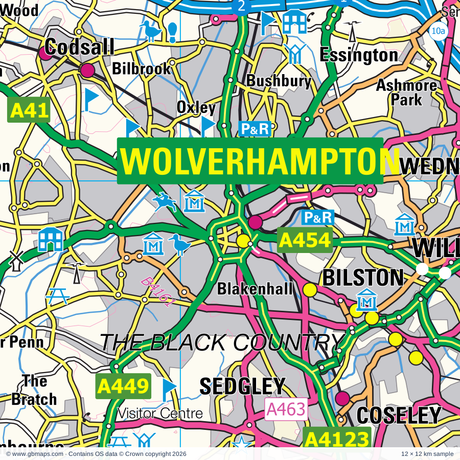
Wolverhampton regional road map. Full 60 × 60 km PDF, SVG and Illustrator files, with a free PDF sample.

GBMAPS.COM

Wolverhampton Regional Road Map

Call Us Now for Help01751 473136

GREAT BRITAIN ROAD ATLAS · 1:250,000 GB-390-0300

Wolverhampton & surrounding area

Explore the full 60 × 60 km Wolverhampton regional road map at 1:250,000, covering Lichfield, Bilston, Sedgley, Willenhall, Coseley. Compare the complete coverage below; a detailed PDF sample is available free.

WOLVERHAMPTON & SURROUNDING AREAREGIONAL ROAD MAP
60 × 60 km · Full map previewDownload the free SVG ↓

INSIDE THE FULL 60 × 60 KM MAP

Explore the Wolverhampton map area

1:250,000 cartography

Towns, villages & places

More mapped places (287)

Roads across this sheet

M5, M6, M40, M42, M54, A5, A34, A38, A38(M), A41, A45, A47, A51, A53, A58, A435, A441, A442, A446, A448, A449, A450, A451, A452

More road numbers

A453, A454, A456, A457, A458, A459, A460, A461, A462, A463, A464, A491, A513, A515, A518, A519, A529, A3400, A4025, A4026, A4029, A4030, A4031, A4033, A4034, A4036, A4037, A4038, A4039, A4040, A4041, A4061, A4091, A4092, A4097, A4098, A4099, A4100, A4101, A4102, A4117, A4123, A4124, A4126, A4141, A4148, A4150, A4167, A4168, A4169, A4182, A4196, A4252, A4400, A4510, A4535, A4540, A4601, A4640, A5013, A5127, A5148, A5190, A5192, A5195, A5206, A5223, B384, B425, B460, B4025, B4043, B4091, B4096, B4100, B4101, B4102, B4114, B4117, B4118, B4119, B4120, B4121, B4122, B4124, B4125, B4126, B4127, B4128, B4129, B4132, B4133, B4135, B4136, B4137, B4138, B4139, B4140, B4142, B4144, B4145, B4146, B4147, B4148, B4149, B4151, B4152, B4153, B4154, B4155, B4156, B4161, B4162, B4163, B4166, B4167, B4169, B4170, B4171, B4172, B4173, B4174, B4175, B4176, B4177, B4178, B4179, B4180, B4182, B4183, B4184, B4185, B4186, B4187, B4188, B4189, B4190, B4193, B4194, B4195, B4196, B4199, B4200, B4201, B4202, B4210, B4214, B4217, B4284, B4363, B4364, B4368, B4371, B4373, B4375, B4376, B4378, B4379, B4380, B4394, B4438, B4439, B4464, B4483, B4484, B4514, B4515, B4516, B4517, B4531, B4532, B4537, B4549, B4551, B4555, B4563, B4583, B4587, B4588, B4590, B5011, B5012, B5013, B5014, B5016, B5017, B5026, B5061, B5062, B5063, B5066, B5234, B5314, B5404, B5405
Rivers & waterways

Balls Hill Branch Canal, Birmingham & Fazeley Canal, Birmingham Canal (Birmingham Level), Birmingham Canal (Wolverhampton Level), Borle Brook, Bradley Locks, Cannock Extension Canal, Coventry Canal, Digbeth Branch Canal, Dudley Canal, Dudley Canal (Netherton Tunnel Branch), Gower Branch Canal

More waterways

Grand Union Canal, Grand Union Canal (Birmingham & Warwick Junction section), Lapworth Link Canal, Pensnett Canal, Rea Brook, River Blithe, River Blythe, River Cole, River Corve, River Dove, River Mease, River Penk, River Rea, River Severn, River Sow, River Stour, River Tame, River Tern, River Trent, River Worfe, Rushall Canal, Shropshire Union Canal, Staffordshire & Hatherton Branch Canal (disused), Staffordshire & Worcester Canal, Staffordshire & Worcestershire Canal, Staffordshire and Worcester Canal, Staffordshire and Worcestershire Canal, Stourbridge Canal, Stratford-upon-Avon Canal, Tame Valley Canal, Titford Canal, Titford Feeder, Trent & Mersey Canal, Walsall Canal, Walsall Canal (Anson Branch), Wide Waters, Worcester & Birmingham Canal, Wyley & Essington Canal (disused), Wyrley & Essington Canal, Wyrley & Essington Canal (disused)

Landmarks & landscape

Amerton Farm & Railway, Ancient High House and Staffordshire Yeomanry Museum, Aqualate Hall, Arley Estate Arboretum, Ash End House Children's Farm, Aston Hall, Aston Manor Transport Museum, Baddesley Clinton, Baggeridge Country Park, Bantock House Museum, Benthall Hall, Bewdley Museum

More named features

Bilston Museum & Art Gallery, Birches Valley Forest Centre, Go Ape Cannock, Birmingham Museum & Art Gallery, The Museum of the Jewellery Quarter, Thinktank,Birmingham Science Museum, Birmingham Sports Centre, Balsall Heath City Farm, Birmingham and Midland Museum of Transport, Black Country Museum, Blackstone Meadows Country Park, Blists Hill Victorian Town, Bodenham Arboretum and Earth Centre, Boscobel House, Botanical Gardens, Boxtrees Farm Craft Centre, Bridgnorth Castle, Broadfield House Glass Museum, Brockswood Animal Sanctuary, Broseley Pipe Works, Museum of the Gorge, Police Museum, Buildwas Abbey, Bumble Hole & Warrens Hall Visitor Centre, Cadbury World, Cannock Chase Country Park, Cannock Chase Visitor Centre, Cannon Hill Country Park, Canon Hill Park, Canwell Hall, Castle Bromwich Hall Gardens, Castle Ring Fort, Chaddesley Corbett Point to Point Course, Chasewater Country Park, Chasewater Railway, Chillington Hall, Christian Heritage Centre, Clent Hills Country Park, Clowes Wood Nature Reserve, Coalbrookdale Museum of Iron, Enginuity, Coalport China Museum, Jackfield Tile Museum, Craft Centre, Curborough Antiques & Craft Centre, Daniel's Mill, Darby Houses, David Austin Roses Ltd, Devil's Spittleful Nature Reserve, Doxey Marshes Nature Reserve, Drayton Manor Family Theme Park, Dudley Castle, Dudley Zoo, Dudmaston Hall, Erasmus Darwin House, Forge Mill Farm, Gailey Pottery, Galton Valley Canal Heritage Centre, Gentleshaw Wildlife Centre, Granville Country Park, Haden Hill House, Hagley Hall, Halesowen Abbey, Halfpenny Green Vineyard, Hartlebury Castle, Hartlebury Common Nature Reserve, Harvington Hall, Hayhead Wood Nature Reserve, Hednesford Hills Common Nature Reserve, Highgate Common, Himley Hall, Hodnet Gardens, Holdens Brewery, Holy Austin Rock Houses, Hoo Farm, Ironbridge Gorge (World Heritage Site), Ironbridge Gorge Tourist Visitor Centre, Isaak Waltons Cottage & Museum, Kidderminster Railway Museum, Museum of Carpet, Kingfisher Country Park, Kingsford Country Park, Kinver Edge, Leapgate Country Park, Letocetum Roman Town, Lichfield Cathedral, Lickey Hills Country Park, Visitor Centre, Lilleshall Abbey, Merridale Nature Reserve, Middleton Hall, Millennium Point, Moseley Old Hall, Museum, Museum of Cannock Chase, National Memorial Aboretum, Visitor Centre, Armed Forces Memorial, National Sea Life Centre, Nature Reserve, Northgate Museum, Northycote Farm and Country Park, Oak House Museum, Packwood House, Parkridge Centre, Patshull Hall, Pendeford Mill Nature Reserve, Pipe Hall Nature Reserve, RAF Museum Cosford, Rays Farm Country Matters, Redhouse and Cone Museum, Remains of Bedlam Furnaces, Rough Wood Country Park, Royal Brierley Experience, Samuel Johnson's Birthplace, Teddy Bear Museum, Sandwell Valley Country Park, Selly Manor Museum, Severn Valley Country Park, Severn Valley Country Park (Highley Mine), Severn Valley Railway, Sheldon Country Park, Shire Country Park, Shugborough Farm Museum, Shugborough Hall, Shugborough Hall, Shugborough Estate NT, Soho House Museum, Solar Farm, St Chad's Cathedral, St Milburga's Priory, St Philip's Cathedral, Stafford Castle, Stanmore Country Park, Sunnycroft, Sutton Park Visitor Centre, Telford Steam Trust, The Barber Institute of Fine Arts, The Engine House Visitor Centre, The Falconry Centre, The Gobbett Rare Breeds Farm, The Leasowes Visitor Centre, The Ruskin Glass Centre, The Staffordshire Regiment Museum, Tudor Crystal, Umberslade Farm Park, Wall Roman Site (Letocetum) Museum, Wallerton Old Hall Garden, Walsall Aboretum, Walsall Museum and Art Gallery, Walsall Leather Centre Museum, Waseley Hills Country Park, Visitor Centre, Wednesbury Museum and Art Gallery, Wenlock Pottery, Weoley Castle, West Midland Safari & Leisure Park, West Midlands Police Museum, Westo Wood Fisheries, Weston Park, Weston Park & Deer Park, Whightwick Manor, Whit Lenge Gardens, White Ladies Priory, Willenhall Museum, Wolverhampton Museum and Art Gallery, Wolverhampton Racecourse, Woodgate Valley Country Park, Woodgate Valley Visitor Centre, Woodgate Valley Urban Farm, Worcestershire County Museum, Wrockwardine Solar Farm, Wyre Valley Visitor Centre, Go Ape Wyre

Local authority & parish coverage

Wholly or partly within the full map rectangle. These boundaries are coverage information, not additional artwork layers.

  • Birmingham DistrictWholly within
  • Bromsgrove DistrictPartly within
  • Cannock Chase DistrictWholly within
  • City of Wolverhampton DistrictWholly within
  • Dudley DistrictWholly within
  • East Staffordshire DistrictPartly within
  • Lichfield DistrictPartly within
  • Malvern Hills DistrictPartly within
  • North Warwickshire DistrictPartly within
  • Sandwell DistrictWholly within
  • ShropshirePartly within
  • Solihull DistrictPartly within
  • South Derbyshire DistrictPartly within
  • South Staffordshire DistrictWholly within
  • Stafford DistrictPartly within
  • Stratford-on-Avon DistrictPartly within
  • Tamworth DistrictPartly within
  • Telford and WrekinPartly within
  • Walsall DistrictWholly within
  • Warwick DistrictPartly within
  • Wychavon DistrictPartly within
  • Wyre Forest DistrictPartly within
Wards & electoral divisions 356 areas
  • Acocks Green Ward
  • Admaston & Bratton Ward
  • Aggborough & Spennells Ward
  • Aldridge Central & South Ward
  • Aldridge North & Walsall Wood Ward
  • Allens Cross Ward
  • Alrewas & Fradley Ward
  • Alum Rock Ward
  • Alvechurch South Ward (part)
  • Alvechurch Village Ward
  • Amblecote Ward
  • Apley Castle Ward
  • Areley Kings & Riverside Ward (part)
  • Arleston & College Ward
  • Armitage with Handsacre Ward
  • Aston Fields Ward (part)
  • Aston Ward
  • Bagots & Needwood Ward (part)
  • Baldwin Ward (part)
  • Balsall Heath West Ward
  • Barnt Green & Hopwood Ward
  • Bartley Green Ward
  • Baswich Ward
  • Bearwood Ward
  • Beechdale, Leamore & Reedswood Ward
  • Belbroughton & Romsley Ward
  • Belle Vale Ward
  • Bentley & Darlaston North Ward
  • Bewdley & Rock Ward (part)
  • Bilbrook Ward
  • Billesley Ward
  • Bilston North Ward
  • Bilston South Ward
  • Birchfield Ward
  • Blackheath Ward
  • Blakebrook & Habberley South Ward
  • Blakenhall Ward
  • Bloxwich East & Blakenall Heath Ward
  • Bloxwich West Ward
  • Blythe Ward
  • Blythe Ward (part)
  • Boley Park Ward
  • Boney Hay & Central Ward
  • Bordesley & Highgate Ward
  • Bordesley Green Ward
  • Bournbrook & Selly Park Ward
  • Bourne Vale Ward (part)
  • Bournville & Cotteridge Ward
  • Brandwood & King's Heath Ward
  • Brereton & Ravenhill Ward
  • Brewood, Coven & Blymhill Ward
  • Brierley Hill & Wordsley South Ward
  • Bristnall Ward
  • Broadwaters Ward
  • Brockmoor & Pensnett Ward
  • Bromford & Hodge Hill Ward
  • Bromsgrove Central Ward (part)
  • Brookside Ward
  • Brownhills Ward
  • Bushbury North Ward
  • Bushbury South & Low Hill Ward
  • Cannock Longford & Bridgtown Ward
  • Cannock Park & Old Fallow Ward
  • Castle & Priory Ward
  • Castle Bromwich Ward
  • Castle Vale Ward
  • Castle Ward (part)
  • Catshill North Ward
  • Catshill South Ward
  • Chadsmead Ward
  • Chadsmoor Ward
  • Charford Ward (part)
  • Charlemont & Grove Vale Ward
  • Chase Terrace Ward
  • Chasetown Ward
  • Chelmsley Wood Ward
  • Cheslyn Hay Village Ward
  • Church Aston & Lilleshall Ward
  • Codsall Ward
  • Cofton Ward
  • Coleshill North Ward (part)
  • Coleshill South Ward (part)
  • Colton & the Ridwares Ward
  • Common Ward
  • Coseley Ward
  • Coton Ward
  • Cradley Heath & Old Hill Ward
  • Cradley North & Wollescote Ward
  • Crown Ward (part)
  • Curborough Ward
  • Curdworth Ward (part)
  • Darlaston South Ward
  • Dawley & Aqueduct Ward
  • Dodderhill Ward (part)
  • Donnington Ward
  • Dorridge & Hockley Heath Ward
  • Dove Ward (part)
  • Doxey & Castletown Ward
  • Drakes Cross Ward
  • Druids Heath & Monyhull Ward
  • East Park Ward
  • Eccleshall Ward (part)
  • Edgbaston Ward
  • Edgmond Ward
  • Elmdon Ward
  • Ercall Magna Ward (part)
  • Ercall Ward
  • Erdington Ward
  • Essington Ward
  • Etching Hill & the Heath Ward
  • Ettingshall North Ward
  • Ettingshall South & Spring Vale Ward
  • Fallings Park Ward
  • Fazeley Ward (part)
  • Featherstone, Sharehill & Saredon Ward
  • Fillongley Ward (part)
  • Foley Park & Hoobrook Ward
  • Fordbridge Ward
  • Forebridge Ward
  • Franche & Habberley North Ward
  • Frankley Great Park Ward
  • Friar Park & Stone Cross Ward
  • Garretts Green Ward
  • Glebe Farm & Tile Cross Ward
  • Gnosall & Woodseaves Ward
  • Gornal Ward
  • Graiseley Ward
  • Gravelly Hill Ward
  • Great Barr, Tamebridge & Yew Tree Ward
  • Great Bridge Ward
  • Great Wyrley Landywood Ward
  • Great Wyrley Town Ward
  • Greets Green & Lyng Ward
  • Hadley & Leegomery Ward
  • Hagley East Ward
  • Hagley West Ward
  • Halesowen North Ward
  • Halesowen South Ward
  • Hall Green North Ward
  • Hall Green South Ward
  • Hammerwich with Wall Ward
  • Handsworth Ward
  • Handsworth Wood Ward
  • Harborne Ward
  • Harden, Goscote & Ryecroft Ward
  • Hartlebury Ward (part)
  • Hateley Heath Ward
  • Hawks Green with Rumer Hill Ward
  • Haygate & Park Ward
  • Hayley Green & Cradley South Ward
  • Haywood & Hixon Ward
  • Heartlands Ward
  • Heath Hayes & Wimblebury Ward
  • Heath Town Ward
  • Hednesford Green Heath Ward
  • Hednesford Hills & Rawnsley Ward
  • Hednesford Pye Green Ward
  • Highfield Ward
  • Highfields & Western Downs Ward
  • Highter's Heath Ward
  • Hill Top Ward (part)
  • Hill Top Ward
  • Hilton Ward (part)
  • Himley & Swindon Ward
  • Hollywood Ward
  • Holmcroft Ward
  • Holyhead Ward
  • Horsehay & Lightmoor Ward
  • Huntington & Hatherton Ward
  • Ironbridge Gorge Ward
  • Kenilworth Abbey & Arden Ward (part)
  • Ketley Ward
  • King's Norton North Ward
  • King's Norton South Ward
  • Kingshurst & Smith's Wood Ward
  • Kingstanding Ward
  • Kingswinford North & Wall Heath Ward
  • Kingswinford South Ward
  • Kinver & Enville Ward
  • Knowle Ward (part)
  • Ladywood Ward
  • Langley Ward
  • Lapley, Stretton & Wheaton Aston Ward
  • Lawley Ward
  • Leomansley Ward
  • Lickey Hills Ward
  • Lickhill Ward
  • Lindridge Ward (part)
  • Little Aston & Stonnall Ward
  • Littleworth Ward
  • Longbridge & West Heath Ward
  • Longdon Ward
  • Lowes Hill Ward
  • Lozells Ward
  • Lye & Stourbridge North Ward
  • Lyndon Ward
  • Madeley & Sutton Hill Ward
  • Malinslee & Dawley Bank Ward
  • Manor Ward
  • Marlbrook Ward
  • Mease Valley Ward (part)
  • Mercian Ward (part)
  • Meriden & Arden Ward (part)
  • Merry Hill Ward
  • Milford Ward
  • Milwich Ward (part)
  • Mitton Ward (part)
  • Moseley Ward
  • Muxton Ward
  • Nechells Ward
  • Netherton & Holly Hall Ward
  • New Invention Ward
  • Newport East Ward
  • Newport North Ward
  • Newport South Ward
  • Newport West Ward
  • Newton & Valley Ward
  • Newtown Ward
  • North Edgbaston Ward
  • Northfield Ward
  • Norton Canes Ward
  • Norton Ward
  • Norton Ward
  • Oakengates & Ketley Bank Ward
  • Offmore & Comberton Ward
  • Old Warley Ward
  • Oldbury Ward
  • Olton Ward
  • Oscott Ward
  • Overdale & The Rock Ward
  • Oxley Ward
  • Paddock Ward
  • Palfrey & The Delves Ward
  • Park Ward
  • Pattingham, Trysull, Bobbington & Lower Penn Ward
  • Pedmore & Stourbridge East Ward
  • Pelsall Ward
  • Penkridge North & Acton Trussell Ward
  • Penkridge South & Gailey Ward
  • Penkside Ward
  • Penn Ward
  • Perry Barr Ward
  • Perry Common Ward
  • Perryfields Ward (part)
  • Perton East Ward
  • Perton Lakeside Ward
  • Perton Wrottesley Ward
  • Pheasey Park Farm Ward
  • Pleck Ward
  • Princes End Ward
  • Priorslee Ward
  • Pype Hayes Ward
  • Quarry Bank & Dudley Wood Ward
  • Quinton Ward
  • Rowley Ward
  • Rowley Ward
  • Rubery & Rednal Ward
  • Rubery North Ward
  • Rubery South Ward
  • Rushall-Shelfield Ward
  • Sanders Park Ward
  • Sedgley Ward
  • Seighford & Church Eaton Ward (part)
  • Shard End Ward
  • Shawbirch & Dothill Ward
  • Sheldon Ward
  • Shenstone Ward
  • Shirley East & Sharmans Cross Ward
  • Shirley South Ward
  • Shirley West Ward
  • Short Heath Ward
  • Sidemoor Ward
  • Silhill Ward
  • Slideslow Ward (part)
  • Small Heath Ward
  • Smethwick Ward
  • Soho & Jewellery Quarter Ward
  • Soho & Victoria Ward
  • South Yardley Ward
  • Sparkbrook & Balsall Heath East Ward
  • Sparkhill Ward
  • St. Alphege with Monkspath & Hillfield Ward
  • St. Georges Ward
  • St. James's Ward
  • St. John's Ward
  • St. Matthew's Ward
  • St. Pauls Ward
  • St. Peters Ward
  • St. Thomas's Ward
  • Stirchley Ward
  • Stockland Green Ward
  • Stowe Ward
  • Streetly Ward
  • Summerfield & All Saints Ward
  • Sutton Four Oaks Ward
  • Sutton Mere Green Ward
  • Sutton Reddicap Ward
  • Sutton Roughley Ward
  • Sutton Trinity Ward
  • Sutton Vesey Ward
  • Sutton Walmley & Minworth Ward
  • Sutton Wylde Green Ward
  • Tanworth-in-Arden Ward (part)
  • Tardebigge Ward (part)
  • Tettenhall Regis Ward
  • Tettenhall Wightwick Ward
  • The Nedge Ward
  • Tipton Green Ward
  • Tividale Ward
  • Tyseley & Hay Mills Ward
  • Upper Gornal & Woodsetton Ward
  • Ward End Ward
  • Water Orton Ward
  • Wednesbury Ward
  • Wednesfield North Ward
  • Wednesfield South Ward
  • Weeping Cross & Wildwood Ward
  • Weoley & Selly Oak Ward
  • West Bromwich Central Ward
  • Western Springs Ward
  • Whittington & Streethay Ward (part)
  • Willenhall Ward
  • Wollaston & Stourbridge Town Ward
  • Wombourne North Ward
  • Wombourne South Ward
  • Woodside Ward
  • Wordsley North Ward
  • Wribbenhall & Arley Ward
  • Wrockwardine Ward (part)
  • Wrockwardine Wood & Trench Ward
  • Wyre Forest Rural Ward (part)
  • Wythall East Ward
  • Wythall West Ward
  • Yardley East Ward
  • Yardley West & Stechford Ward
  • Albrighton ED
  • Bridgnorth Castle ED
  • Bridgnorth East ED
  • Bridgnorth South & Alveley ED
  • Bridgnorth West & Tasley ED
  • Broseley ED
  • Brown Clee ED (part)
  • Cheswardine ED (part)
  • Claverley & Worfield ED
  • Clee ED (part)
  • Cleobury Mortimer ED (part)
  • Corvedale ED (part)
  • Highley ED
  • Hodnet ED (part)
  • Much Wenlock ED (part)
  • Severn Valley ED (part)
  • Shawbury ED (part)
  • Shifnal North ED
  • Shifnal Rural ED
  • Shifnal South ED
  • Stottesdon, Kinlet & Hopton Wafers ED (part)
Civil parishes & communities 282 areas
  • Abbots Bromley CP
  • Acton Round CP
  • Acton Trussell and Bednall CP
  • Adbaston CP (part)
  • Albrighton and Donington CP
  • Alrewas CP
  • Alvechurch CP (part)
  • Alveley CP
  • Anslow CP (part)
  • Armitage with Handsacre CP
  • Astley Abbotts CP
  • Astley and Dunley CP (part)
  • Aston Botterell CP
  • Aston Eyre CP
  • Baddesley Clinton CP (part)
  • Badger CP
  • Barnt Green CP
  • Barrow CP
  • Barston CP (part)
  • Barton-under-Needwood CP (part)
  • Bayton CP
  • Beckbury CP
  • Belbroughton CP
  • Beoley CP (part)
  • Berkswich CP
  • Bewdley CP
  • Bickenhill and Marston Green CP (part)
  • Bilbrook CP
  • Billingsley CP
  • Bitterley CP (part)
  • Blithfield CP
  • Blymhill and Weston-under-Lizard CP
  • Bobbington CP
  • Boningale CP
  • Boraston CP (part)
  • Bournheath CP
  • Bradley CP
  • Brereton and Ravenhill CP
  • Brewood and Coven CP
  • Bridgnorth CP
  • Bridgtown CP
  • Brindley Heath CP
  • Brocton CP
  • Broome CP
  • Broseley CP
  • Buildwas CP
  • Burford CP (part)
  • Burntwood CP
  • Burwarton CP (part)
  • Bushwood CP (part)
  • Cannock Wood CP
  • Castle Bromwich CP
  • Catshill and North Marlbrook CP
  • Chaddesley Corbett CP
  • Chadwick End CP (part)
  • Chebsey CP (part)
  • Chelmarsh CP
  • Chelmsley Wood CP
  • Cheslyn Hay CP
  • Cheswardine CP (part)
  • Cheswick Green CP
  • Chetton CP
  • Chetwynd Aston and Woodcote CP
  • Chetwynd CP
  • Child's Ercall CP
  • Church Aston CP
  • Church Eaton CP
  • Churchill and Blakedown CP
  • Claverley CP
  • Clent CP
  • Cleobury Mortimer CP
  • Cleobury North CP (part)
  • Codsall CP
  • Cofton Hackett CP
  • Coleshill CP (part)
  • Colton CP
  • Colwich CP
  • Coppenhall CP
  • Coreley CP (part)
  • Cressage CP (part)
  • Creswell CP
  • Curborough and Elmhurst CP
  • Curdworth CP (part)
  • Dawley Hamlets CP
  • Deuxhill CP
  • Dickens Heath CP
  • Ditton Priors CP (part)
  • Dodford with Grafton CP (part)
  • Donnington and Muxton CP
  • Doxey CP
  • Draycott in the Clay CP (part)
  • Drayton Bassett CP (part)
  • Dunstall CP (part)
  • Dunston CP
  • Eardington CP
  • Eccleshall CP (part)
  • Edgmond CP
  • Edingale CP (part)
  • Elford CP (part)
  • Ellenhall CP
  • Elmbridge CP (part)
  • Elmley Lovett CP (part)
  • Enville CP
  • Ercall Magna CP (part)
  • Essington CP
  • Eyton upon the Weald Moors CP
  • Farewell and Chorley CP
  • Farlow CP
  • Fazeley CP (part)
  • Featherstone CP
  • Finstall CP (part)
  • Fisherwick CP
  • Fordbridge CP
  • Forton CP
  • Foston and Scropton CP (part)
  • Fradley CP
  • Fradswell CP (part)
  • Frankley CP
  • Gayton CP (part)
  • Glazeley CP
  • Gnosall CP
  • Great Dawley CP
  • Great Wyrley CP
  • Hadley and Leegomery CP
  • Hagley CP
  • Hammerwich CP
  • Hampton in Arden CP (part)
  • Hamstall Ridware CP
  • Hanbury CP (part)
  • Harlaston CP (part)
  • Harley CP (part)
  • Hartlebury CP (part)
  • Hatherton CP
  • Haughton CP
  • Heath Hayes and Wimblebury CP
  • Hednesford CP
  • High Offley CP
  • Highley CP
  • Hilton CP
  • Himley CP
  • Hinstock CP
  • Hints CP
  • Hixon CP
  • Hoar Cross CP
  • Hockley Heath CP
  • Hodnet CP (part)
  • Hollinswood and Randlay CP
  • Hopton Wafers CP (part)
  • Hopton and Coton CP
  • Hunnington CP
  • Huntington CP
  • Hyde Lea CP
  • Ingestre CP
  • Kemberton CP
  • Ketley CP
  • Kidderminster CP
  • Kidderminster Foreign CP
  • King's Bromley CP
  • Kingsbury CP (part)
  • Kingshurst CP
  • Kingstone CP (part)
  • Kinlet CP
  • Kinver CP
  • Knighton on Teme CP (part)
  • Kynnersley CP
  • Lapley, Stretton and Wheaton Aston CP
  • Lapworth CP (part)
  • Lawley and Overdale CP
  • Lea Marston CP (part)
  • Leighton and Eaton Constantine CP (part)
  • Lichfield CP
  • Lickey and Blackwell CP
  • Lilleshall CP
  • Lindridge CP (part)
  • Little Packington CP (part)
  • Little Wenlock CP
  • Longdon CP
  • Lower Penn CP
  • Madeley CP
  • Mamble CP (part)
  • Marchington CP (part)
  • Marston CP (part)
  • Mavesyn Ridware CP
  • Middleton CP (part)
  • Middleton Scriven CP
  • Milson CP
  • Monkhopton CP (part)
  • Morville CP
  • Much Wenlock CP (part)
  • Nash CP (part)
  • Neen Savage CP
  • Neen Sollars CP
  • Neenton CP
  • New Frankley in Birmingham CP
  • Newborough CP
  • Newport CP
  • Norbury CP
  • Norton Canes CP
  • Oakengates CP
  • Pattingham and Patshull CP
  • Penkridge CP
  • Perton CP
  • Preston upon the Weald Moors CP
  • Quatt Malvern CP
  • Ranton CP
  • Ribbesford CP
  • Rock CP (part)
  • Rodington CP (part)
  • Romsley CP
  • Romsley CP
  • Rowington CP (part)
  • Rudge CP
  • Rugeley CP
  • Rushock CP (part)
  • Ryton CP
  • Salt and Enson CP
  • Sandon and Burston CP (part)
  • Saredon CP
  • Seighford CP
  • Shareshill CP
  • Shawbury CP (part)
  • Sheinton CP
  • Shenstone CP
  • Sheriffhales CP
  • Shifnal CP
  • Shustoke CP (part)
  • Sidbury CP
  • Smith's Wood CP
  • St. Georges and Priorslee CP
  • Stanton Long CP (part)
  • Stanton upon Hine Heath CP (part)
  • Stirchley and Brookside CP
  • Stockton CP
  • Stoke St. Milborough CP (part)
  • Stoke upon Tern CP (part)
  • Stone CP
  • Stone Rural CP (part)
  • Stottesdon CP
  • Stourport-on-Severn CP (part)
  • Stowe-by-Chartley CP (part)
  • Streethay CP
  • Sutton Coldfield CP
  • Sutton Maddock CP
  • Sutton upon Tern CP (part)
  • Swindon CP
  • Swinfen and Packington CP
  • Tanworth-in-Arden CP (part)
  • Tasley CP
  • Tatenhill CP (part)
  • Teddesley Hay CP
  • The Gorge CP
  • Tibberton and Cherrington CP
  • Tidbury Green CP
  • Tixall CP
  • Tong CP
  • Trysull and Seisdon CP
  • Tutbury CP (part)
  • Tutnall and Cobley CP (part)
  • Upper Arley CP
  • Upton Cressett CP
  • Upton Warren CP (part)
  • Uttoxeter Rural CP (part)
  • Wall CP
  • Water Orton CP
  • Waters Upton CP
  • Weeford CP
  • Wellington CP
  • Weston CP
  • Wheathill CP (part)
  • Whitgreave CP (part)
  • Whittington CP
  • Wigginton and Hopwas CP (part)
  • Wishaw CP
  • Wolverley and Cookley CP
  • Wombourne CP
  • Worfield CP
  • Wrockwardine CP (part)
  • Wrockwardine Wood and Trench CP
  • Wroxeter and Uppington CP (part)
  • Wychnor CP (part)
  • Wythall CP
  • Yoxall CP

Source: the GBMaps road atlas, OS Boundary-Line and postcode mapping datasets. Source editions are being checked for publication. Unmarked boundary names are wholly within the sheet; “part” means the map edge crosses the area.

Place lists are selected from the map source, not a complete gazetteer. Named features describe the cartography; visitor facilities and opening status are not verified. The free sample covers only 12 × 12 km of this larger sheet.

INSIDE YOUR DOWNLOAD

A proper road map, in useful formats

Road classifications, towns and villages, railways, rivers, landscape detail and tourist symbols, brought together in the GBMaps regional road atlas style.

PDF filePDFSVG fileSVGAdobe Illustrator AI fileAi

PDF for the finished map. SVG and layered Illustrator artwork for adapting colours, adding your own information and preparing designs.

THE FINISHED SHEET

Designed for print and presentation

Map coverage
60 × 60 km
Sample coverage
12 × 12 km
Print layout
A3 landscape · enlarged 1:250k cartography
Sheet furniture
Border, scale bar, key & north arrow

A few useful details

What changes when I select another square?

Select a surrounding square to bring it into the centre and reveal the maps around it. Each square is a different 60 × 60 km map. The preview, free sample and selected download change together. Neighbouring sheets overlap by 30 km so you can choose the coverage that suits you.

Is the free sample a vector map?

The on-page detail is an SVG. The free download is a separate 12 × 12 km PDF with a link to the full map. Please retain its copyright credits and product link when sharing it.

Can I buy a larger combined map?

These downloads are individual ready-made sheets. Contact GBMaps if you need a larger combined area.

FREE PDF SAMPLE

Your free map sample

Your free 12 × 12 km sample includes a link back to this map, so you can return for the full area whenever you need it.

Download free PDF sample ↓

Get your Wolverhampton map

Map download bundle

£24.00including VATOne payment

Pay securely

One payment. Your map stays open.

Your map download

Your map files

Preparing your download…

Checking your private download link…

Your map downloads

Already bought a map?

Find the downloads from your purchases.

Enter the email address you used at checkout. We’ll email you a private link to your available map downloads.