Winchester regional road map. Full 60 × 60 km PDF, SVG and Illustrator files, with a free PDF sample.

GBMAPS.COM

Winchester Regional Road Map

Call Us Now for Help01751 473136

GREAT BRITAIN ROAD ATLAS · 1:250,000 GB-450-0150

Winchester & surrounding area

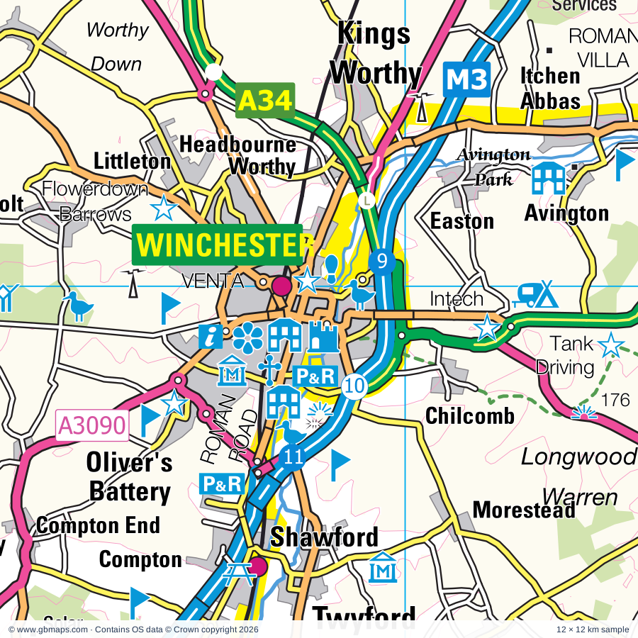
Explore the full 60 × 60 km Winchester regional road map at 1:250,000, covering Winchester, Whitchurch, Basingstoke, Andover, Newbury. Compare the complete coverage below; a detailed PDF sample is available free.

WINCHESTER & SURROUNDING AREAREGIONAL ROAD MAP
60 × 60 km · Full map previewDownload the free SVG ↓

INSIDE THE FULL 60 × 60 KM MAP

Explore the Winchester map area

1:250,000 cartography

Towns, villages & places

More mapped places (295)
  • Litchfield
  • Hannington
  • Oakley
  • Sydmonton
  • Ibworth
  • Old Burghclere
  • Binley
  • Popham
  • Longparish
  • Kingsclere
  • Middleton
  • Upper Bullington
  • Lower Bullington
  • Dummer
  • Woodmancott
  • Stoke
  • Wolverton
  • Whitway
  • Ecchinswell
  • Wonston
  • Micheldever
  • East Stratton
  • Ashmansworth
  • Burghclere
  • Ramsdell
  • West Heath
  • Broadmere
  • Highclere
  • Headley
  • Ibthorpe
  • Axford
  • Cliddesden
  • Faccombe
  • Baughurst
  • Northington
  • Newtown
  • Ellisfield
  • East End
  • Wherwell
  • Chilbolton
  • Wildhern
  • Upton
  • Crookham
  • Charlton
  • Greenham
  • Hatherden
  • Winslade
  • Linkenholt
  • Bradley
  • Brimpton
  • Wasing
  • Fullerton
  • Combe
  • West Woodhay
  • Herriard
  • Crawley
  • Enborne
  • Upper Wield
  • Tangley
  • Silchester
  • Leckford
  • Aldermaston
  • Aldermaston Soke
  • Southrope
  • Easton
  • Tunworth
  • Midgham
  • Clanville
  • Bramley
  • Avington
  • Woolhampton
  • Littleton
  • Weyhill
  • Bramley Green
  • Church End
  • Upper Green
  • Mapledurwell
  • Hattingley
  • Lasham
  • Bentworth
  • Appleshaw
  • Ovington
  • Bighton
  • Inkpen
  • Chute Standen
  • Cold Ash
  • Ashmore Green
  • Stockcross
  • Monxton
  • Longstock
  • Buttermere
  • Fosbury
  • Bagnor
  • Up Nately
  • Sparsholt
  • Padworth
  • Up Somborne
  • Medstead
  • Gundleton
  • Kintbury
  • Halfway
  • Amport
  • Stockbridge
  • Beenham
  • Newnham
  • Tichborne
  • Shalden
  • Mortimer
  • Fyfield
  • Soldridge
  • Thedden
  • Ham
  • Bucklebury
  • Thruxton
  • Wickham Heath
  • Oxenwood
  • Curridge
  • Chilcomb
  • Rivar
  • Stratfield Saye
  • Kentsboro
  • Turgis Green
  • Greywell
  • Rotherwick
  • Longlane
  • Kimpton
  • Avington
  • Beech
  • Winterbourne
  • Ashley
  • Tidcombe
  • Southend
  • Boxford
  • Shalbourne
  • Hook
  • Sulhamstead
  • Cheriton
  • Ropley
  • Hermitage
  • Quarley
  • Frilsham
  • Kitwood
  • Grateley
  • Bagshot
  • Marten
  • Houghton
  • Odiham
  • Wickham
  • Perham Down
  • Chieveley
  • Chawton
  • Morestead
  • Standon
  • Beech Hill
  • Wexcombe
  • Burghfield
  • Mattingley
  • Bramdean
  • Welford
  • Heckfield
  • Yattendon
  • Bradfield
  • Horsebridge
  • Shawford
  • Beauworth
  • Holybourne
  • Compton
  • Englefield
  • Kilmeston
  • Monkwood
  • Twyford
  • West Green
  • Palestine
  • Broughton
  • Hursley
  • Wilton
  • Riseley
  • Grazeley
  • Hazeley
  • Weston
  • Brunton
  • Little Bedwyn
  • Swallowfield
  • Well
  • Great Bedwyn
  • Winchfield
  • Brook
  • Owslebury
  • Leckhampstead
  • Aughton
  • Crofton
  • Otterbourne
  • Bramshill
  • Froxfield
  • East Tisted
  • Beedon
  • Peasemore
  • Chisbury
  • Wyck
  • Ashampstead
  • Braishfield
  • Tidmarsh
  • Sulham
  • Michelmersh
  • Cholderton
  • Binsted
  • Mill Lane
  • Hartfordbridge
  • Dogmersfield
  • Ampfield
  • Chaddleworth
  • Privett
  • Mottisfont
  • Farley Hill
  • Timsbury
  • Stanmore
  • Burbage
  • Bentley
  • Selborne
  • West Meon
  • Warnford
  • Shinfield
  • Crondall
  • Everleigh
  • Upham
  • Pangbourne
  • Durley
  • Belbins
  • Abbotswood
  • Compton
  • Brightwalton
  • Aldworth
  • East Winterslow
  • Wheatley
  • Oakhanger
  • Whitchurch-on-Thames
  • Eversley
  • Whittonditch
  • Arborfield
  • Blacknest
  • Kingsley
  • Eastbury
  • Exton
  • Lockerley
  • Ramsbury
  • Awbridge
  • Allington
  • Empshott
  • Corhampton
  • High Cross
  • Mapledurham
  • Meonstoke
  • Boscombe
  • Hawkley
  • Blackmoor
  • Newtown
  • Finchampstead
  • Barkham
  • Caversham
  • East Meon
  • Axford
  • Whitehill
  • Langrish
  • Firsdown
  • West Dean
  • Cadley
  • Lambourn
  • Greatham
  • Sindlesham
  • Steep
  • Farley
  • Pitton
  • Stroud
  • Ramsdean
  • Aldbourne
  • Mildenhall
  • Winnersh
  • Baydon
  • Liss
  • Sheet
  • Sonning
  • Weston
  • Whiteparish
  • Newton
  • Charvil
  • Buriton
  • Woodsend
  • Hurst
  • Shiplake
  • Twyford
  • Nursted
  • Ruscombe
  • Wargrave
  • Lover
  • Redlynch

Roads across this sheet

M3, M4, A4, A27, A30, A31, A32, A33, A272, A287, A321, A323, A325, A327, A329, A329(M), A335, A338, A339, A340, A342, A343, A346, A3010

More road numbers

A3026, A3032, A3057, A3090, A3093, A3290, A4074, A4155, B471, B477, B478, B481, B2070, B2146, B2177, B2199, B3002, B3004, B3006, B3011, B3016, B3018, B3024, B3030, B3031, B3035, B3040, B3041, B3043, B3044, B3045, B3046, B3047, B3048, B3049, B3051, B3079, B3080, B3084, B3087, B3270, B3272, B3330, B3331, B3335, B3345, B3348, B3349, B3350, B3354, B3398, B3400, B3402, B3404, B3420, B3421, B3430, B4000, B4001, B4009, B4192, B4446, B4494, B4526, B4640

Rivers & waterways

Basingstoke Canal, Blackwater River, Holy Brook, Kennet & Avon Canal, River Avon, River Bourne, River Hart, River Itchen, River Kennet, River Lambourn, River Loddon, River Meon

More waterways

River Pang, River Rother, River Slea, River Test, River Thames, River Wey, River Whitewater, The Itchen Navigation

Landmarks & landscape

21 South Street Arts Centre, 4 Kingdoms Adventure Park, Aldermaston Wharf Canal Visitor Centre, Allen Gallery & Curtis Museum, Anton Lakes Nature Reserve, Avington Park, Basildon House and Park, Basing House, Beale Park Wildlife Park, Blackbushe, Blackmoor Copse, Broadlands House, NEW FOREST NATIONAL PARK, SOUTH DOWNS NATIONAL PARK

More named features

Broadlands House, King John's House, Tudor Cottage & Heritage Centre, Bucklebury Common Nature Reserve, Bucklebury Farm Park, CALLEVA, California Country Park, Calleva Museum, Calleva Roman Town Wall, Calleva Roman Town Amphitheatre, Chisbury Chapel - St Martin's Chapel, Chisbury Chapel/St Martin's Chapel, Cholderton Rare Breeds Farm, Crab Wood Nature Reserve, Crofton Beam Engines, Danebury Ring (Iron Age Hill Fort), Dinton Pastures Country Park, Donnington Castle, Donnington Castle (remains of), Englefield Garden, Farley Mount Country Park, Finkley Down Farm Park, Fisherton Mill, Flowerdown Barrows, Greenham and Crookham Nature Reserve, Herbert Plantation, Highclere Castle, Highclere Park Gardens, Hinton Ampner, Hinton Ampner Garden, Hinton Ampner House, Houghton Lodge Gardens, Hyde Abbey Gateway, Inkpen Common Nature Reserve, Inkpen Long Barrow, Intech Science Centre, Itchen Abbas Roman Villa, Itchen Valley Brewery, Jane Austen's House Museum, Kings Royal Hussars, Royal Greenjackets, Gurkha, Great Hall & Round Table, Landford Manor, Littlecote, Lockerley Hall, Longstock Park Water Gardens, Ludgershall Castle, Ludgershall Castle and Cross, Mapledurham House, Mapledurham Watermill, Marwell Wildlife, Meon Pottery, Mid Hants Railway, Milestones Living History Museum, Monument, Mottisfont Abbey, Mottisfont Abbey Garden, House & Estate, Museum of Army Flying Explorers' World, Museum of Berkshire Aviation, Museum of Reading, Blakes Lock Museum, Museum of English Rural Life, Museum of the Iron Age, Newbury Racecourse, Newbury Showground, Noar Hill Nature Reserve, Odiham Castle, Old Winchester Hill Nature Reserve, Oliver Cromwell's Battery, Pepperbox Hill Nature Reserve, Petersfield Museum, Pierces Solar Farm, Queen Eleanor's Garden, R.E.M.E Museum, Roche Court New Arts Centre, Romsey Abbey, Sandham Memorial Chapel, Second World War Aircraft Preservation Society, Selborne Hill Nature Reserve, Shipton Bellinger Solar Farm, Shortheath Common Nature Reserve, Sir Harold Hillier Gardens & Arboretum, Snelsmore Common Country Park, Solar Farm, St Catherine's Hill Nature Reserve, St Cross Hospital, Steventon Pottery, Stratfield Saye House, Tank Driving Experience, Thatcham Reed Beds, The Fairground Craft & Design Centre, The Grange, The Hawk Conservancy, The Living Rainforest, The Oates Museum/Gilberts Whites House, The Pottery, The Vyne, Thruxton Motor Racing Circuit, Twyford Waterworks Pumping Station, Visitor Centre, Welford Park Gardens, Wellington Country Park, West Berkshire Museum, West Green House Garden, Whitchurch Silk Mill, Whitehill Lane Solar Farm, Willis Museum, Wilton Windmill, Winchester Cathedral, Winchester City, Westgate, Royal Hampshire Regiment, Winchester Great Hall, Winchester College, Winnal Moors Nature Reserve, Wolvesey Castle
Local authority & parish coverage

Wholly or partly within the full map rectangle. These boundaries are coverage information, not additional artwork layers.

  • Basingstoke and Deane DistrictWholly within
  • Chichester DistrictPartly within
  • East Hampshire DistrictPartly within
  • Eastleigh DistrictPartly within
  • Hart DistrictPartly within
  • ReadingWholly within
  • South Oxfordshire DistrictPartly within
  • SwindonPartly within
  • Test Valley DistrictPartly within
  • West BerkshirePartly within
  • WiltshirePartly within
  • Winchester DistrictPartly within
  • WokinghamPartly within
Wards & electoral divisions 157 areas
  • Abbey Ward
  • Aldermaston Ward
  • Alresford & Itchen Valley Ward
  • Alton Amery Ward
  • Alton Ashdell Ward
  • Alton Eastbrooke Ward
  • Alton Holybourne Ward
  • Alton Westbrooke Ward
  • Alton Whitedown Ward
  • Alton Wooteys Ward
  • Ampfield & Braishfield Ward
  • Andover Downlands Ward
  • Andover Harroway Ward
  • Andover Millway Ward
  • Andover Romans Ward
  • Andover St. Mary's Ward
  • Andover Winton Ward
  • Anna Ward
  • Badger Farm & Oliver's Battery Ward
  • Barkham & Arborfield Ward
  • Basildon Ward (part)
  • Basing & Upton Grey Ward
  • Battle Ward
  • Bellinger Ward
  • Bentworth & Froyle Ward
  • Binsted, Bentley & Selborne Ward (part)
  • Bishop's Waltham Ward (part)
  • Bishopstoke Ward (part)
  • Blackwater Ward (part)
  • Bourne Valley Ward
  • Bradfield Ward
  • Bramley Ward
  • Brighton Hill Ward
  • Brookvale & Kings Furlong Ward
  • Bucklebury Ward
  • Bulmershe & Coronation Ward
  • Burghfield & Mortimer Ward
  • Buriton & East Meon Ward (part)
  • Caversham Heights Ward
  • Caversham Ward
  • Central Meon Valley Ward (part)
  • Chandler's Ford Ward (part)
  • Charlton & the Pentons Ward
  • Chieveley & Cold Ash Ward
  • Chineham Ward
  • Chiseldon & Ridgeway Ward (part)
  • Church Ward
  • Colden Common & Twyford Ward
  • Coley Ward
  • Crookham West and Ewshot Ward (part)
  • Downlands Ward (part)
  • Eastleigh North Ward (part)
  • Eastrop & Grove Ward
  • Emmbrook Ward (part)
  • Emmer Green Ward
  • Evendons Ward (part)
  • Evingar Ward
  • Fair Oak & Horton Heath Ward (part)
  • Finchampstead Ward (part)
  • Fleet Central Ward (part)
  • Fleet West Ward (part)
  • Four Marks & Medstead Ward
  • Froxfield, Sheet & Steep Ward
  • Goring Ward (part)
  • Harewood Ward
  • Harting Ward (part)
  • Hartley Wintney Ward (part)
  • Hatch Warren & Beggarwood Ward
  • Hawkedon Ward
  • Hillside Ward
  • Hiltingbury Ward
  • Hook Ward
  • Hungerford & Kintbury Ward
  • Katesgrove Ward
  • Kempshott & Buckskin Ward
  • Kentwood Ward
  • Kidmore End & Whitchurch Ward (part)
  • Lambourn Ward (part)
  • Liss Ward (part)
  • Loddon Ward
  • Maiden Erlegh & Whitegates Ward
  • Mid Test Ward
  • Newbury Central Ward
  • Newbury Clay Hill Ward
  • Newbury Greenham Ward
  • Newbury Speen Ward
  • Newbury Wash Common Ward
  • Norcot Ward
  • Norden Ward
  • North Baddesley Ward (part)
  • Oakley & The Candovers Ward
  • Odiham Ward (part)
  • Pangbourne Ward
  • Park Ward
  • Petersfield Bell Hill Ward
  • Petersfield Causeway Ward
  • Petersfield Heath Ward
  • Petersfield St. Peter's Ward
  • Popley Ward
  • Redlands Ward
  • Ridgeway Ward (part)
  • Romsey Abbey Ward (part)
  • Romsey Cupernham Ward
  • Romsey Tadburn Ward (part)
  • Ropley, Hawkley & Hangers Ward
  • Sherborne St. John & Rooksdown Ward
  • Shinfield Ward
  • Sonning Common Ward (part)
  • South Ham Ward
  • South Lake Ward
  • Southcote Ward
  • Spencers Wood & Swallowfield Ward
  • St. Barnabas Ward
  • St. Bartholomew Ward
  • St. Luke Ward
  • St. Michael Ward
  • St. Paul Ward
  • Tadley & Pamber Ward
  • Tadley North, Kingsclere & Baughurst Ward
  • Thames Ward
  • Thames Ward (part)
  • Thatcham Central Ward
  • Thatcham Colthrop & Crookham Ward
  • Thatcham North East Ward
  • Thatcham West Ward
  • The Worthys Ward
  • Theale Ward
  • Tilehurst & Purley Ward
  • Tilehurst Birch Copse Ward
  • Tilehurst South & Holybrook Ward
  • Tilehurst Ward
  • Twyford, Ruscombe & Hurst Ward (part)
  • Upper Meon Valley Ward (part)
  • Valley Park Ward (part)
  • Whitchurch, Overton & Laverstoke Ward
  • Whitehill Chase Ward (part)
  • Whitehill Hogmoor & Greatham Ward (part)
  • Whitehill Pinewood Ward (part)
  • Whitley Ward
  • Winklebury & Manydown Ward
  • Winnersh Ward (part)
  • Wonston & Micheldever Ward
  • Yateley West Ward (part)
  • Aldbourne & Ramsbury ED (part)
  • Alderbury & Whiteparish ED (part)
  • Amesbury East & Bulford ED (part)
  • Avon Valley ED (part)
  • Downton & Ebble Valley ED (part)
  • Ludgershall North & Rural ED (part)
  • Marlborough East ED (part)
  • Old Sarum & Lower Bourne Valley ED (part)
  • Pewsey ED (part)
  • Pewsey Vale East ED
  • Redlynch & Landford ED (part)
  • Tidworth East & Ludgershall South ED
  • Tidworth North & West ED
  • Winterslow & Upper Bourne Valley ED (part)
Civil parishes & communities 343 areas
  • Abbotts Ann CP
  • Aldbourne CP (part)
  • Alderbury CP (part)
  • Aldermaston CP
  • Aldworth CP (part)
  • Allbrook CP
  • Allington CP (part)
  • Alton CP
  • Amesbury CP (part)
  • Ampfield CP
  • Amport CP
  • Andover CP
  • Appleshaw CP
  • Arborfield and Newland CP
  • Ashampstead CP
  • Ashford Hill with Headley CP
  • Ashley CP
  • Ashmansworth CP
  • Awbridge CP
  • Badger Farm CP
  • Barkham CP
  • Barton Stacey CP
  • Basildon CP
  • Baughurst CP
  • Baydon CP (part)
  • Beauworth CP
  • Beech CP
  • Beech Hill CP
  • Beedon CP (part)
  • Beenham CP
  • Bentley CP (part)
  • Bentworth CP
  • Bighton CP
  • Binfield Heath CP (part)
  • Binsted CP (part)
  • Bishops Sutton CP
  • Bishops Waltham CP (part)
  • Bishopstoke CP (part)
  • Bishopstone CP (part)
  • Bossington CP
  • Boxford CP
  • Bradfield CP
  • Bradley CP
  • Braishfield CP
  • Bramdean and Hinton Ampner CP
  • Bramley CP
  • Bramshill CP
  • Brightwalton CP (part)
  • Brimpton CP
  • Broughton CP
  • Buckholt CP
  • Bucklebury CP
  • Bulford CP (part)
  • Bullington CP
  • Burbage CP
  • Burghclere CP
  • Burghfield CP
  • Buriton CP (part)
  • Buttermere CP
  • Candovers CP
  • Catmore CP (part)
  • Chaddleworth CP (part)
  • Chandler's Ford CP (part)
  • Charlton CP
  • Charvil CP
  • Chawton CP
  • Cheriton CP
  • Chieveley CP
  • Chilbolton CP
  • Chilcomb CP
  • Chilton Foliat CP
  • Chineham CP
  • Chiseldon CP (part)
  • Cholderton CP
  • Chute CP
  • Chute Forest CP
  • Clarendon Park CP (part)
  • Cliddesden CP
  • Cold Ash CP
  • Colden Common CP
  • Colemore and Priors Dean CP
  • Collingbourne Ducis CP
  • Collingbourne Kingston CP
  • Combe CP
  • Compton CP (part)
  • Compton and Shawford CP
  • Corhampton and Meonstoke CP (part)
  • Crawley CP
  • Crondall CP (part)
  • Crookham Village CP (part)
  • Deane CP
  • Dogmersfield CP
  • Downton CP (part)
  • Droxford CP (part)
  • Dummer CP
  • Earley CP
  • East Dean CP
  • East Garston CP (part)
  • East Ilsley CP (part)
  • East Meon CP (part)
  • East Tisted CP
  • East Tytherley CP
  • East Woodhay CP
  • Eastleigh Town CP (part)
  • Easton CP (part)
  • Ecchinswell, Sydmonton and Bishops Green CP
  • Ellisfield CP
  • Elvetham Heath CP (part)
  • Enborne CP
  • Englefield CP
  • Enham Alamein CP
  • Everleigh CP (part)
  • Eversley CP (part)
  • Exton CP
  • Eye and Dunsden CP
  • Faccombe CP
  • Fair Oak and Horton Heath CP (part)
  • Farleigh Wallop CP
  • Farnborough CP (part)
  • Farringdon CP
  • Fawley CP (part)
  • Figheldean CP (part)
  • Finchampstead CP (part)
  • Firsdown CP (part)
  • Fittleton cum Haxton CP (part)
  • Fleet CP (part)
  • Four Marks CP
  • Frenchmoor CP
  • Frilsham CP
  • Froxfield CP
  • Froxfield and Privett CP
  • Froyle CP
  • Fyfield CP
  • Goodworth Clatford CP
  • Goring Heath CP (part)
  • Goring-on-Thames CP (part)
  • Grafton CP
  • Grateley CP
  • Great Bedwyn CP
  • Great Shefford CP
  • Greatham CP
  • Greenham CP
  • Greywell CP
  • Grimstead CP
  • Ham CP
  • Hambledon CP (part)
  • Hampstead Marshall CP
  • Hampstead Norreys CP
  • Hannington CP
  • Harpsden CP (part)
  • Harting CP (part)
  • Hartley Wespall CP
  • Hartley Wintney CP (part)
  • Hawkley CP
  • Headbourne Worthy CP
  • Heckfield CP
  • Hermitage CP
  • Herriard CP
  • Highclere CP
  • Holybrook CP
  • Hook CP
  • Houghton CP
  • Hungerford CP
  • Hursley CP
  • Hurstbourne Priors CP
  • Hurstbourne Tarrant CP
  • Idmiston CP (part)
  • Inkpen CP
  • Itchen Stoke and Ovington CP
  • Itchen Valley CP
  • Kidmore End CP (part)
  • Kilmiston CP
  • Kimpton CP
  • Kings Somborne CP
  • Kings Worthy CP
  • Kingsclere CP
  • Kingsley CP (part)
  • Kintbury CP
  • Lambourn CP (part)
  • Landford CP (part)
  • Langrish CP
  • Lasham CP
  • Laverstoke CP
  • Leckford CP
  • Leckhampstead CP
  • Liddington CP (part)
  • Linkenholt CP
  • Liss CP (part)
  • Litchfield and Woodcott CP
  • Little Bedwyn CP
  • Little Somborne CP
  • Littleton and Harestock CP
  • Lockerley CP
  • Long Sutton CP
  • Longparish CP
  • Longstock CP
  • Ludgershall CP
  • Mapledurham CP
  • Mapledurwell and Up Nately CP
  • Marlborough CP (part)
  • Mattingley CP
  • Medstead CP
  • Melchet Park and Plaitford CP (part)
  • Micheldever CP
  • Michelmersh and Timsbury CP
  • Midgham CP
  • Mildenhall CP (part)
  • Milston CP (part)
  • Milton Lilbourne CP (part)
  • Monk Sherborne CP
  • Monxton CP
  • Mortimer West End CP
  • Mottisfont CP
  • Nether Wallop CP
  • New Alresford CP
  • Newbury CP
  • Newnham CP
  • Newton Tony CP
  • Newton Valence CP
  • Newtown CP
  • North Baddesley CP (part)
  • North Waltham CP
  • Northington CP
  • Nutley CP
  • Oakley CP
  • Odiham CP
  • Ogbourne St. Andrew CP (part)
  • Ogbourne St. George CP (part)
  • Old Alresford CP
  • Old Basing and Lychpit CP
  • Olivers Battery CP
  • Otterbourne CP
  • Over Wallop CP
  • Overton CP
  • Owslebury CP (part)
  • Padworth CP
  • Pamber CP
  • Pangbourne CP
  • Peasemore CP (part)
  • Penton Grafton CP
  • Penton Mewsey CP
  • Petersfield CP
  • Pitton and Farley CP (part)
  • Popham CP
  • Preston Candover CP
  • Purley on Thames CP
  • Quarley CP
  • Ramsbury CP
  • Redlynch CP (part)
  • Rogate CP (part)
  • Romsey CP (part)
  • Rooksdown CP
  • Ropley CP
  • Rotherwick CP
  • Ruscombe CP (part)
  • Savernake CP (part)
  • Selborne CP
  • Shalbourne CP
  • Shalden CP
  • Shaw cum Donnington CP
  • Sheet CP
  • Sherborne St. John CP
  • Sherfield English CP
  • Sherfield Park CP
  • Sherfield on Loddon CP
  • Shinfield CP
  • Shiplake CP (part)
  • Shipton Bellinger CP
  • Silchester CP
  • Smannell CP
  • Sonning CP
  • Sonning Common CP (part)
  • South Warnborough CP
  • South Wonston CP
  • Sparsholt CP
  • Speen CP
  • St. Mary Bourne CP
  • St. Nicholas, Hurst CP (part)
  • Stanford Dingley CP
  • Steep CP
  • Steventon CP
  • Stockbridge CP
  • Stratfield Mortimer CP
  • Stratfield Saye CP
  • Stratfield Turgis CP
  • Streatley CP (part)
  • Stroud CP
  • Sulham CP
  • Sulhamstead CP
  • Swallowfield CP
  • Tadley CP
  • Tangley CP
  • Thatcham CP
  • Theale CP
  • Thruxton CP
  • Tichborne CP
  • Tidcombe and Fosbury CP
  • Tidmarsh CP
  • Tidworth CP
  • Tilehurst CP
  • Tunworth CP
  • Twyford CP
  • Twyford CP
  • Ufton Nervet CP
  • Upham CP (part)
  • Upper Clatford CP
  • Upton Grey CP
  • Valley Park CP (part)
  • Vernhams Dean CP
  • Wanborough CP (part)
  • Wargrave CP (part)
  • Warnford CP
  • Wasing CP
  • Welford CP
  • Wellow CP (part)
  • West Dean CP
  • West Meon CP (part)
  • West Tisted CP
  • West Tytherley CP
  • West Woodhay CP
  • Weston Corbett CP
  • Weston Patrick CP
  • Wherwell CP
  • Whitchurch CP
  • Whitchurch-on-Thames CP
  • Whitehill CP (part)
  • Whiteparish CP
  • Wield CP
  • Winchfield CP
  • Winnersh CP (part)
  • Winslade CP
  • Winterbourne CP
  • Winterslow CP
  • Wokefield CP
  • Wokingham CP (part)
  • Wonston CP
  • Woodley CP
  • Woolhampton CP
  • Wootton Rivers CP (part)
  • Wootton St. Lawrence with Ramsdell CP
  • Worldham CP
  • Yateley CP (part)
  • Yattendon CP

Source: the GBMaps road atlas, OS Boundary-Line and postcode mapping datasets. Source editions are being checked for publication. Unmarked boundary names are wholly within the sheet; “part” means the map edge crosses the area.

Place lists are selected from the map source, not a complete gazetteer. Named features describe the cartography; visitor facilities and opening status are not verified. The free sample covers only 12 × 12 km of this larger sheet.

INSIDE YOUR DOWNLOAD

A proper road map, in useful formats

Road classifications, towns and villages, railways, rivers, landscape detail and tourist symbols, brought together in the GBMaps regional road atlas style.

PDF filePDFSVG fileSVGAdobe Illustrator AI fileAi

PDF for the finished map. SVG and layered Illustrator artwork for adapting colours, adding your own information and preparing designs.

THE FINISHED SHEET

Designed for print and presentation

Map coverage
60 × 60 km
Sample coverage
12 × 12 km
Print layout
A3 landscape · enlarged 1:250k cartography
Sheet furniture
Border, scale bar, key & north arrow

A few useful details

What changes when I select another square?

Select a surrounding square to bring it into the centre and reveal the maps around it. Each square is a different 60 × 60 km map. The preview, free sample and selected download change together. Neighbouring sheets overlap by 30 km so you can choose the coverage that suits you.

Is the free sample a vector map?

The on-page detail is an SVG. The free download is a separate 12 × 12 km PDF with a link to the full map. Please retain its copyright credits and product link when sharing it.

Can I buy a larger combined map?

These downloads are individual ready-made sheets. Contact GBMaps if you need a larger combined area.

FREE PDF SAMPLE

Your free map sample

Your free 12 × 12 km sample includes a link back to this map, so you can return for the full area whenever you need it.

Download free PDF sample ↓

Get your Winchester map

Map download bundle

£24.00including VATOne payment

Pay securely

One payment. Your map stays open.

Your map download

Your map files

Preparing your download…

Checking your private download link…

Your map downloads

Already bought a map?

Find the downloads from your purchases.

Enter the email address you used at checkout. We’ll email you a private link to your available map downloads.