Truro regional road map. Full 60 × 60 km PDF, SVG and Illustrator files, with a free PDF sample.

GBMAPS.COM

Truro Regional Road Map

Call Us Now for Help01751 473136

GREAT BRITAIN ROAD ATLAS · 1:250,000 GB-180-0060

Truro & surrounding area

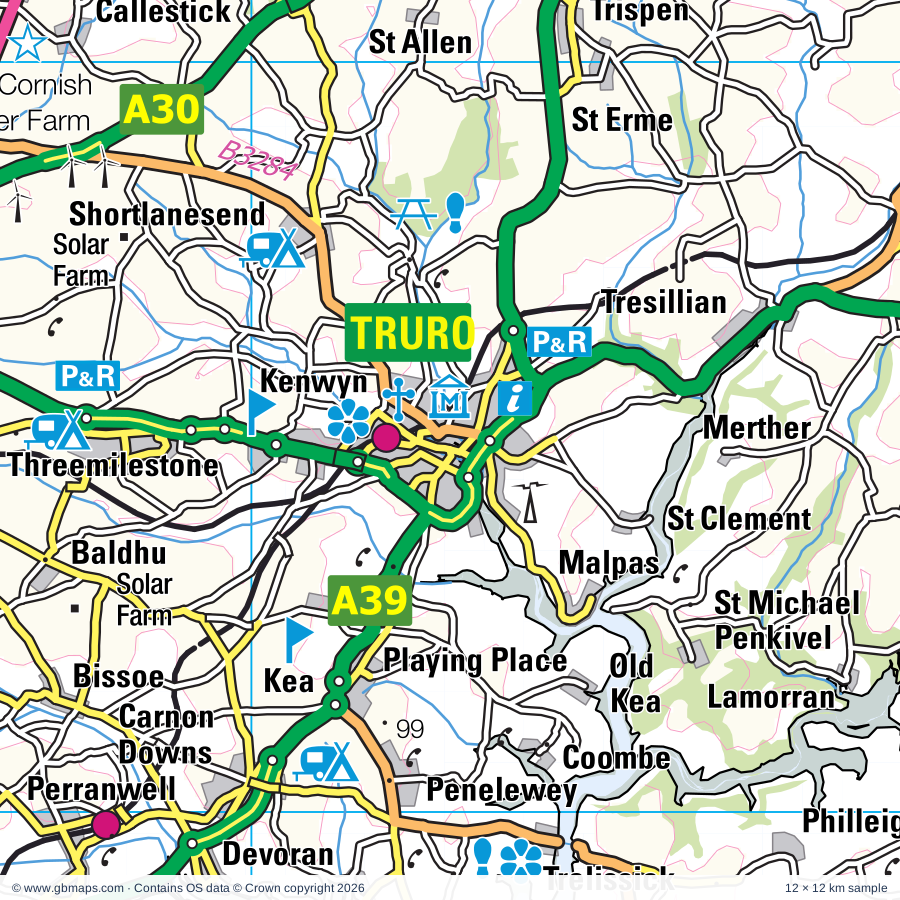
Explore the full 60 × 60 km Truro regional road map at 1:250,000, covering Truro, St Columb Major, Padstow, Redruth, Wadebridge. Compare the complete coverage below; a detailed PDF sample is available free.

TRURO & SURROUNDING AREAREGIONAL ROAD MAP
60 × 60 km · Full map previewDownload the free SVG ↓

INSIDE THE FULL 60 × 60 KM MAP

Explore the Truro map area

1:250,000 cartography

Towns, villages & places

More mapped places (241)

Roads across this sheet

A38, A39, A389, A390, A391, A392, A393, A394, A3047, A3058, A3059, A3074, A3075, A3076, A3078, A3082, B3263, B3266, B3267, B3268, B3269, B3273, B3274, B3275

More road numbers

B3276, B3277, B3279, B3280, B3284, B3285, B3287, B3289, B3292, B3297, B3298, B3300, B3301, B3302, B3303, B3306, B3309, B3311, B3314, B3374

Rivers & waterways

De Lank River, River Allen, River Camel, River Fal, River Fowey, River Hayle

Landmarks & landscape

ATV Motor Sport Centre (Motor Racing Circuit), Argal & College Water Park, Barbara Hepworth Museum and Sculpture Garden, St Ives Museum, Blue Hills Tin Streams, Blue Reef Aquarium, Bodmin Town Museum, Bodmin Gaol, The Courtroom Experience, Duke of Cornwall's Light Infantry Museum, Bodmin and Wenford Railway (Tourist Railway), Bosvigo, Breney Common Nature Reserve, Buccaneer Bay, Trenance Leisure Park, Caerhays Castle Gardens, Camborne Geological Museum

More named features

Camel Valley Vineyards, Charlestown Shipwreck, Rescue & Heritage Centre, China Clay Country Park Museum (World Heritage Site), Cornish Birds of Prey Centre, Cornish Engines, Cornish Beam Engine Museum, Cornish Mines and Engines (World Heritage Site), Cornish Studies Library (World Heritage Site), Cornwall County Showground, Crealy Adventure Park, Dairyland Farm World, Delobole Slate Quarry, Dingerein Castle, East Wheal Rose Engine House, Eden Project, Falmouth Arts Centre, Falmouth Art Gallery, Godolphin House, Godolphin House & Garden (World Heritage Site), Grennap Pit (World Heritage Site) & Visitor Centre, Gyllyngnune Gardens, Queen Mary Gardens, Hawksland Solar Farm, Heartlands Point (World Heritage Site), Helman Tor Nature Reserve, Helston Preserved Railway, Hidden Valley Garden, Hollywell Bay Fun Park, John Betjeman Centre, King Edward Mine (World Heritage Site), King Edward Mine Museum, King's Wood Nature Reserve, Lanhydrock, Lanhydrock House, Lappa Valley Steam Railway, Longcross Victorian Gardens, Lostwithiel Museum, Marazion Museum, Marsh Villa Gardens, Melinsey Mill, Mevagissey Aquarium, Mevagissey Museum, Mineral Tramways Discovery Centre (World Heritage Site), Monument, National Lobster Hatchery, National Maritime Museum Cornwall, Newquay Zoo, North Cornwall Museum, Old MacDonalds Farm, Padstow Town Museum, Paradise Park and the World Parrot Trust, Pencarrow, Pendennis Castle, Penjerrick Garden, Perranzabuloe Museum, Pine Lodge Gardens, Polmassick Vineyard, Port Isaac Pottery, Porth Reservoir, Portreath Bee Centre, Prideaux Place, Ropehaven Cliffs Nature Reserve, Roseland Visitor Centre, Royal Cornwall Museum (World Heritage Site), Screech Owl Sanctuary, Shire Horse Farm & Carriage Museum, Solar Farm, Solar Farm Butteris Downs, St Agnes Museum (World Heritage Site), St Austell Brewery, St Breock Downs Monolith, St Erth Pottery, St Mawes Castle, St Mawgan Japanese Garden, St Michael's Mount, Tate St Ives, Penwith Galleries, Tehidy Country Park, The Cornish Cyder Farm, The Lost Gardens of Heligan, The Poldark Mine (World Heritage Site), The Round Garden, Tintagel Castle, Tintagel Old Post Office, Treasure Park, Tolgus Tin Works, Tregarne Solar Farm, Tregrehan Gardens, Trelissick Gardens, Trerice, Trevaunance Cove Craft Workshops, Trewithen Gardens, Truro Cathedral, Visitor Centre, Wheal Jane Solar Farm, Wingz Bird & Animal Sanctuary
Local authority & parish coverage

Wholly or partly within the full map rectangle. These boundaries are coverage information, not additional artwork layers.

  • CornwallPartly within
Wards & electoral divisions 61 areas
  • Bodmin St. Mary's & St Leonard ED
  • Bodmin St. Petroc's ED (part)
  • Camborne Roskear & Tuckingmill ED
  • Camborne Trelowarren ED
  • Camborne West & Treswithian ED
  • Camelford & Boscastle ED (part)
  • Constantine, Mabe & Mawnan ED (part)
  • Crowan, Sithney & Wendron ED (part)
  • Falmouth Arwenack ED
  • Falmouth Boslowick ED (part)
  • Falmouth Penwerris ED
  • Falmouth Trescobeas & Budock ED (part)
  • Feock & Kea ED
  • Four Lanes, Beacon & Troon ED
  • Fowey, Tywardreath & Par ED (part)
  • Gloweth, Malabar & Shortlanesend ED
  • Gwinear-Gwithian & Hayle East ED
  • Hayle West ED
  • Illogan & Portreath ED
  • Lanivet, Blisland & Bodmin St. Lawrence ED (part)
  • Lanner, Stithians & Gwennap ED
  • Long Rock, Marazion & St. Erth ED (part)
  • Lostwithiel & Lanreath ED (part)
  • Ludgvan, Madron, Gulval & Heamoor ED (part)
  • Mevagissey & St. Austell Bay ED
  • Mylor, Perranarworthal & Ponsanooth ED
  • Newquay Central & Pentire ED
  • Newquay Porth & Tretherras ED
  • Newquay Trenance ED
  • Padstow ED
  • Penryn ED
  • Penwithick & Boscoppa ED
  • Perranporth ED
  • Pool & Tehidy ED
  • Porthleven, Breage & Germoe ED (part)
  • Probus & St. Erme ED
  • Redruth Central, Carharrack & St. Day ED
  • Redruth North ED
  • Redruth South ED
  • Roche & Bugle ED
  • St. Agnes ED
  • St. Austell Bethel & Holmbush ED
  • St. Austell Central & Gover ED
  • St. Austell Poltair & Mount Charles ED
  • St. Blazey ED
  • St. Columb Major, St Mawgan & St Wenn ED
  • St. Columb Minor & Colan ED
  • St. Dennis & St Enoder ED
  • St. Goran, Tregony & the Roseland ED
  • St. Ives East, Lelant & Carbis Bay ED (part)
  • St. Ives West & Towednack ED (part)
  • St. Mewan & Grampound ED
  • St. Newlyn East, Cubert & Goonhavern ED
  • St. Stephen-in-Brannel ED
  • St. Teath & Tintagel ED (part)
  • Threemilestone & Chacewater ED
  • Truro Boscawen & Redannick ED
  • Truro Moresk & Trehaverne ED
  • Truro Tregolls ED
  • Wadebridge East & St. Minver ED
  • Wadebridge West & St. Mabyn ED
Civil parishes & communities 114 areas
  • Advent CP (part)
  • Blisland CP (part)
  • Bodmin CP (part)
  • Breage CP (part)
  • Budock CP (part)
  • Camborne CP
  • Camelford CP (part)
  • Cardinham CP (part)
  • Carharrack CP
  • Carlyon CP
  • Carn Brea CP
  • Chacewater CP
  • Colan CP
  • Constantine CP (part)
  • Crantock CP
  • Crowan CP
  • Cubert CP
  • Delabole CP
  • Egloshayle CP
  • Falmouth CP (part)
  • Feock CP
  • Forrabury and Minster CP (part)
  • Fowey CP (part)
  • Germoe CP (part)
  • Gerrans CP
  • Grampound with Creed CP
  • Gwennap CP
  • Gwinear-Gwithian CP
  • Hayle CP
  • Helland CP (part)
  • Illogan CP
  • Kea CP
  • Kenwyn CP
  • Ladock CP
  • Lanhydrock CP (part)
  • Lanivet CP
  • Lanlivery CP (part)
  • Lanner CP
  • Lostwithiel CP (part)
  • Ludgvan CP (part)
  • Luxulyan CP
  • Mabe CP
  • Marazion CP (part)
  • Mawgan-in-Pydar CP
  • Mawnan CP (part)
  • Mevagissey CP
  • Michaelstow CP
  • Mylor CP
  • Newquay CP
  • Padstow CP
  • Penryn CP
  • Pentewan Valley CP
  • Perranarworthal CP
  • Perranuthnoe CP (part)
  • Perranzabuloe CP
  • Philleigh CP
  • Ponsanooth CP
  • Portreath CP
  • Probus CP
  • Redruth CP
  • Roche CP
  • Ruanlanihorne CP
  • Sithney CP (part)
  • St. Agnes CP
  • St. Allen CP
  • St. Austell Bay CP
  • St. Austell CP
  • St. Blaise CP
  • St. Breock CP
  • St. Breward CP (part)
  • St. Clement CP
  • St. Columb Major CP
  • St. Day CP
  • St. Dennis CP
  • St. Endellion CP
  • St. Enoder CP
  • St. Erme CP
  • St. Erth CP
  • St. Ervan CP
  • St. Eval CP
  • St. Ewe CP
  • St. Goran CP
  • St. Hilary CP (part)
  • St. Issey CP
  • St. Ives CP (part)
  • St. Just-in-Roseland CP
  • St. Kew CP
  • St. Mabyn CP
  • St. Merryn CP
  • St. Mewan CP
  • St. Michael Caerhays CP
  • St. Michael Penkevil CP
  • St. Michael's Mount CP (part)
  • St. Minver Highlands CP
  • St. Minver Lowlands CP
  • St. Newlyn East CP
  • St. Sampson CP (part)
  • St. Stephen-in-Brannel CP
  • St. Teath CP
  • St. Tudy CP
  • St. Wenn CP
  • St. Winnow CP (part)
  • Stithians CP
  • Tintagel CP (part)
  • Towednack CP (part)
  • Tregony with Cuby CP
  • Trevalga CP (part)
  • Treverbyn CP
  • Truro CP
  • Tywardreath and Par CP (part)
  • Veryan CP
  • Wadebridge CP
  • Wendron CP (part)
  • Withiel CP

Source: the GBMaps road atlas, OS Boundary-Line and postcode mapping datasets. Source editions are being checked for publication. Unmarked boundary names are wholly within the sheet; “part” means the map edge crosses the area.

Place lists are selected from the map source, not a complete gazetteer. Named features describe the cartography; visitor facilities and opening status are not verified. The free sample covers only 12 × 12 km of this larger sheet.

INSIDE YOUR DOWNLOAD

A proper road map, in useful formats

Road classifications, towns and villages, railways, rivers, landscape detail and tourist symbols, brought together in the GBMaps regional road atlas style.

PDF filePDFSVG fileSVGAdobe Illustrator AI fileAi

PDF for the finished map. SVG and layered Illustrator artwork for adapting colours, adding your own information and preparing designs.

THE FINISHED SHEET

Designed for print and presentation

Map coverage
60 × 60 km
Sample coverage
12 × 12 km
Print layout
A3 landscape · enlarged 1:250k cartography
Sheet furniture
Border, scale bar, key & north arrow

A few useful details

What changes when I select another square?

Select a surrounding square to bring it into the centre and reveal the maps around it. Each square is a different 60 × 60 km map. The preview, free sample and selected download change together. Neighbouring sheets overlap by 30 km so you can choose the coverage that suits you.

Is the free sample a vector map?

The on-page detail is an SVG. The free download is a separate 12 × 12 km PDF with a link to the full map. Please retain its copyright credits and product link when sharing it.

Can I buy a larger combined map?

These downloads are individual ready-made sheets. Contact GBMaps if you need a larger combined area.

FREE PDF SAMPLE

Your free map sample

Your free 12 × 12 km sample includes a link back to this map, so you can return for the full area whenever you need it.

Download free PDF sample ↓

Get your Truro map

Map download bundle

£24.00including VATOne payment

Pay securely

One payment. Your map stays open.

Your map download

Your map files

Preparing your download…

Checking your private download link…

Your map downloads

Already bought a map?

Find the downloads from your purchases.

Enter the email address you used at checkout. We’ll email you a private link to your available map downloads.