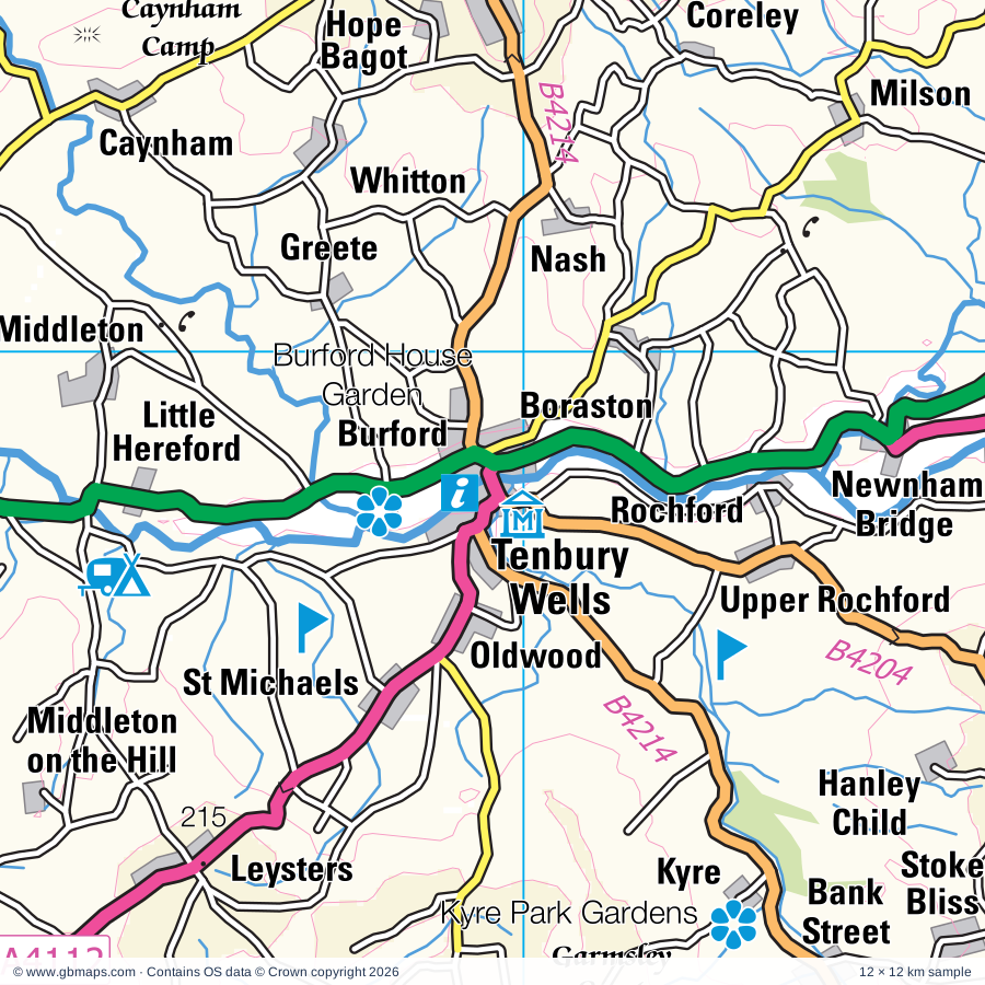
Tenbury Wells regional road map. Full 60 × 60 km PDF, SVG and Illustrator files, with a free PDF sample.

GBMAPS.COM

Tenbury Wells Regional Road Map

Call Us Now for Help01751 473136

GREAT BRITAIN ROAD ATLAS · 1:250,000 GB-360-0270

Tenbury Wells & surrounding area

Explore the full 60 × 60 km Tenbury Wells regional road map at 1:250,000, covering Worcester, Ludlow, Leominster, Bromyard, Bewdley. Compare the complete coverage below; a detailed PDF sample is available free.

TENBURY WELLS & SURROUNDING AREAREGIONAL ROAD MAP
60 × 60 km · Full map previewDownload the free SVG ↓

INSIDE THE FULL 60 × 60 KM MAP

Explore the Tenbury Wells map area

1:250,000 cartography

Towns, villages & places

More mapped places (384)

Roads across this sheet

M5, A38, A41, A44, A417, A438, A442, A443, A448, A449, A450, A451, A454, A456, A458, A461, A463, A465, A480, A488, A489, A491, A4025, A4101

More road numbers

A4102, A4103, A4104, A4110, A4111, A4112, A4113, A4117, A4133, A4169, A4440, A4535, A4536, A4538, B4084, B4090, B4161, B4175, B4176, B4178, B4180, B4186, B4188, B4189, B4190, B4193, B4194, B4195, B4196, B4197, B4199, B4201, B4202, B4203, B4204, B4205, B4206, B4208, B4209, B4211, B4214, B4218, B4219, B4220, B4230, B4232, B4348, B4352, B4355, B4356, B4358, B4359, B4360, B4361, B4362, B4363, B4364, B4365, B4367, B4368, B4369, B4370, B4371, B4373, B4375, B4376, B4378, B4383, B4385, B4424, B4457, B4482, B4485, B4503, B4529, B4530, B4537, B4549, B4550, B4555, B4636, B4637, B4638, B4639, B5477

Rivers & waterways

Borle Brook, Canal (disused), Droitwich Barge Canal, Ledwyche Brook, Letton Lake, Rea Brook, River Arrow, River Clun, River Corve, River Dore, River East Onny, River Frome

More waterways

River Leadon, River Lodon, River Lugg, River Onny, River Rea, River Severn, River Stour, River Teme, River West Onny, River Worfe, River Wye, Staffordshire & Worcestershire Canal, Stourbridge Canal, Worcester & Birmingham Canal

Landmarks & landscape

Acton Scott Working Farm, Arley Estate Arboretum, Arthur's Stone, Astley Vineyard, Baggeridge Country Park, Bantock House Museum, Berrington Hall, Bevere Vivis Gallery, Bewdley Museum, Bircher Common, Blackstone Meadows Country Park, Bodenham Arboretum and Earth Centre

More named features

Bridgnorth Castle, Broadfield House Glass Museum, Broadfields Vineyards, Brobury Garden, Bryans Ground Gardens, Burford House Garden, Burton Court, Bury Ditches, Carding Mill Valley, Chaddesley Corbett Point to Point Course, Clives Fruit Farm, Clunton Coppice Nature Reserve, Coddington Vineyard, Croft Castle, Croome Park, Daniel's Mill, Devil's Spittleful Nature Reserve, Droitwich Spa Heritage Centre, Dudmaston Hall, Dunkerton's Cider Mill, Edvin Loach Old Church, Elton Hall Garden, Frome Valley Vineyard, Gateway Museum, Halfpenny Green Vineyard, Hartlebury Castle, Hartlebury Common Nature Reserve, Harvington Hall, Hereford Cathedral, Hereford Racecourse, Highgate Common, Himley Hall, Holy Austin Rock Houses, Hopton Mountain Bike Trails, House on Crutches Museum, Bishop's Castle Railway Museum, Kidderminster Railway Museum, Museum of Carpet, Kingsford Country Park, Kington Museum, Kinver Edge, Knapp & Papermill Nature Reserve, Kyre Park Gardens, Leapgate Country Park, Leigh Court Barn, Leominster Folk Museum, Lower Brockhampton, Ludlow Castle, Ludlow Museum, Ludlow Racecourse, Mark Griffiths Pottery, Merridale Nature Reserve, Mitchell's Fold Stone Circle, Mocca's Court, Monk Wood Nature Reserve, Mortimer's Cross Water Mill, Museum, Northgate Museum, Oaker Wood, Queenswood Country Park, Ravenshill Nature Reserve, Rays Farm Country Matters, Redhouse and Cone Museum, Severn Valley Country Park, Severn Valley Country Park (Highley Mine), Severn Valley Railway, Shipton Hall, Shobdon Arches Visitor Centre, Shortwood Family Farm, Spetchley Park Gardens, St Ann's Well, Stanmore Country Park, Stockton Bury Gardens, Stokesay Castle, Taste for Adventure, Tenbury Wells Museum, The Bannut, The Bog Visitor Centre, The Commandery, The Elgar Birthplace Museum, The Engine House Visitor Centre, The Falconry Centre, The Gobbett Rare Breeds Farm, The Greyfriars, The Picton Garden & Old Court Nurseries, The Pleck Cheese Dairy, The Ruskin Glass Centre, The Spaceguard Centre, The Stiperstones, The Time Machine Museum , Cafe & Local History Centre, The Weir, The Wernlas Collection, Three Counties Showground, Tudor Crystal, Van Kampen Gardens, Visitor Centre, Walcot, Walcot Hall Gardens and Aboretum, Warren Farm, Weobley Museum, West Midland Safari & Leisure Park, Westonbury Mill, Whightwick Manor, Whit Lenge Gardens, Wigmore Castle, Wilderhope Manor, Withybeds and Wents Meadow, Witley Court, Wolverhampton Racecourse, Worcester Cathedral, Worcester City Museum and Art Gallery, Tudor House, Museum of Worcester Porcelain, Worcester Foregate St Museum, The Commandery, Worcester Racecourse, Worcester Woods Country Park, Worcestershire County Museum, Wyre Valley Visitor Centre, Go Ape Wyre
Local authority & parish coverage

Wholly or partly within the full map rectangle. These boundaries are coverage information, not additional artwork layers.

  • Bromsgrove DistrictPartly within
  • City of Wolverhampton DistrictPartly within
  • County of HerefordshirePartly within
  • Dudley DistrictPartly within
  • Malvern Hills DistrictPartly within
  • Powys - PowysPartly within
  • ShropshirePartly within
  • South Staffordshire DistrictPartly within
  • Worcester DistrictWholly within
  • Wychavon DistrictPartly within
  • Wyre Forest DistrictPartly within
Wards & electoral divisions 144 areas
  • Aggborough & Spennells Ward
  • Alfrick, Leigh & Rushwick Ward
  • Amblecote Ward (part)
  • Arboretum Ward
  • Areley Kings & Riverside Ward
  • Arrow Ward (part)
  • Aylestone Hill Ward (part)
  • Backbury Ward (part)
  • Baldwin Ward
  • Barnards Green Ward
  • Battenhall Ward
  • Bewdley & Rock Ward
  • Bircher Ward
  • Bishops Frome & Cradley Ward
  • Blakebrook & Habberley South Ward
  • Bobblestock Ward
  • Bowbrook Ward (part)
  • Brierley Hill & Wordsley South Ward (part)
  • Broadheath Ward
  • Broadwaters Ward
  • Brockmoor & Pensnett Ward (part)
  • Bromyard Bringsty Ward
  • Bromyard West Ward
  • Castle Ward (part)
  • Castlemorton, Welland & Wells Ward (part)
  • Cathedral Ward
  • Central Ward (part)
  • Claines Ward
  • College Ward
  • Credenhill Ward (part)
  • Dines Green & Grove Farm Ward
  • Dodderhill Ward (part)
  • Drakes Broughton, Norton & Whittington Ward (part)
  • Droitwich East Ward (part)
  • Droitwich South East Ward (part)
  • Droitwich South West Ward (part)
  • Droitwich West Ward
  • Eckington Ward (part)
  • Eign Hill Ward (part)
  • Foley Park & Hoobrook Ward
  • Fort Royal Ward
  • Franche & Habberley North Ward
  • Golden Valley North Ward (part)
  • Gornal Ward (part)
  • Graiseley Ward (part)
  • Great Malvern Ward
  • Greyfriars Ward (part)
  • Hagley Ward (part)
  • Hagley West Ward (part)
  • Hallow & Holt Ward
  • Hampton Ward
  • Hartlebury Ward
  • Himley & Swindon Ward (part)
  • Holmer Ward
  • Hope End Ward (part)
  • Kempsey Ward
  • Kings Acre Ward
  • Kingswinford North & Wall Heath Ward (part)
  • Kingswinford South Ward (part)
  • Kington Ward (part)
  • Kinver & Enville Ward
  • Ledbury North Ward (part)
  • Leominster East Ward
  • Leominster North & Rural Ward
  • Leominster South Ward
  • Leominster West Ward
  • Leopard Hill Ward
  • Lickhill Ward
  • Lindridge Ward
  • Link Ward
  • Lower Wick & Pitmaston Ward
  • Martley Ward
  • Merry Hill Ward
  • Mitton Ward
  • Mortimer Ward
  • North Claines & Salwarpe Ward (part)
  • Norton Ward (part)
  • Nunnery Ward
  • Offmore & Comberton Ward
  • Ombersley Ward (part)
  • Park Ward (part)
  • Pattingham, Trysull, Bobbington & Lower Penn Ward (part)
  • Penn Ward (part)
  • Perton East Ward (part)
  • Perton Lakeside Ward (part)
  • Perton Wrottesley Ward (part)
  • Pickersleigh Ward
  • Powick & the Hanleys Ward
  • Queenswood Ward
  • Rainbow Hill Ward
  • St. Clement Ward
  • St. John's Ward
  • St. Nicholas Ward
  • St. Peter's Parish Ward
  • St. Stephen Ward
  • Stoney Street Ward (part)
  • Sutton Walls Ward
  • Tenbury Ward
  • Tettenhall Regis Ward (part)
  • Tettenhall Wightwick Ward (part)
  • Three Crosses Ward (part)
  • Tupsley Ward (part)
  • Upper Howsell Ward
  • Upton & Ripple Ward (part)
  • Upton Snodsbury Ward (part)
  • Warndon & Elbury Park Ward
  • Weobley Ward
  • West Ward
  • Whitecross Ward
  • Widemarsh Ward
  • Wollaston & Stourbridge Town Ward (part)
  • Wombourne North Ward (part)
  • Wombourne South Ward
  • Wordsley North Ward (part)
  • Wribbenhall & Arley Ward
  • Wyre Forest Rural Ward (part)
  • Bishop's Castle ED (part)
  • Bridgnorth Castle ED
  • Bridgnorth East ED
  • Bridgnorth South & Alveley ED
  • Bridgnorth West & Tasley ED
  • Brown Clee ED
  • Burnell ED (part)
  • Chirbury & Worthen ED (part)
  • Churchstoke ED (part)
  • Claverley & Worfield ED (part)
  • Clee ED
  • Cleobury Mortimer ED
  • Clun ED (part)
  • Corvedale ED
  • Craven Arms ED
  • Highley ED
  • Knighton with Beguildy ED (part)
  • Llangunllo with Norton ED (part)
  • Ludlow East ED
  • Ludlow North ED
  • Ludlow South ED
  • Much Wenlock ED (part)
  • Old Radnor ED (part)
  • Presteigne ED (part)
  • Severn Valley ED (part)
  • Shifnal Rural ED (part)
  • Stottesdon, Kinlet & Hopton Wafers ED
  • The Strettons ED
Civil parishes & communities 375 areas
  • Abberley CP
  • Abdon and Heath CP
  • Acton Beauchamp CP
  • Acton Round CP
  • Acton Scott CP
  • Adforton CP
  • Alfrick CP
  • All Stretton CP
  • Almeley CP
  • Alveley CP
  • Ashford Bowdler CP
  • Ashford Carbonel CP
  • Ashperton CP
  • Astley Abbotts CP
  • Astley and Dunley CP
  • Aston Botterell CP
  • Aston Eyre CP
  • Avenbury CP
  • Aymestrey CP
  • Badger CP (part)
  • Barrow CP (part)
  • Bartestree CP (part)
  • Bayton CP
  • Bedstone CP
  • Besford CP (part)
  • Bewdley CP
  • Billingsley CP
  • Birley with Upper Hill CP
  • Bishop's Castle CP (part)
  • Bishop's Frome CP
  • Bishopstone CP
  • Bitterley CP
  • Blakemere CP (part)
  • Bobbington CP
  • Bockleton CP
  • Bodenham CP
  • Boraston CP
  • Bosbury CP
  • Brampton Bryan CP
  • Bransford CP
  • Bredenbury CP
  • Bredicot CP (part)
  • Bredwardine CP
  • Breinton CP (part)
  • Bridge Sollers CP
  • Bridgnorth CP
  • Brimfield CP
  • Brinsop and Wormsley CP
  • Broadwas CP
  • Brobury with Monnington on Wye CP
  • Brockhampton CP
  • Bromfield CP
  • Bromyard and Winslow CP
  • Broome CP (part)
  • Bucknell CP
  • Buckton and Coxall CP
  • Burford CP
  • Burghill CP
  • Burrington CP
  • Burwarton CP
  • Byford CP
  • Byton CP
  • Canon Frome CP
  • Canon Pyon CP
  • Cardington CP
  • Castle Frome CP
  • Caynham CP
  • Chaddesley Corbett CP (part)
  • Chelmarsh CP
  • Chetton CP
  • Chirbury with Brompton CP (part)
  • Church Preen CP
  • Church Pulverbatch CP (part)
  • Church Stretton CP
  • Churchill and Blakedown CP
  • Churchstoke Community (part)
  • Claverley CP
  • Clee St. Margaret CP
  • Cleobury Mortimer CP
  • Cleobury North CP
  • Clifford CP (part)
  • Clifton upon Teme CP
  • Clun CP (part)
  • Clunbury CP
  • Clungunford CP
  • Coddington CP
  • Colebatch CP (part)
  • Collington CP
  • Colwall CP (part)
  • Combe CP
  • Coreley CP
  • Cotheridge CP
  • Cound CP (part)
  • Cradley and Storridge CP
  • Craven Arms CP
  • Credenhill CP
  • Croft and Yarpole CP
  • Croome D'abitot CP
  • Culmington CP
  • Defford CP (part)
  • Deuxhill CP
  • Diddlebury CP
  • Dilwyn CP
  • Dinmore CP
  • Ditton Priors CP
  • Docklow and Hampton Wafer CP
  • Doddenham CP
  • Dodderhill CP (part)
  • Dormington CP (part)
  • Dorstone CP (part)
  • Doverdale CP
  • Downton CP
  • Drakes Broughton and Wadborough CP (part)
  • Droitwich Spa CP (part)
  • Eardington CP
  • Eardisland CP
  • Eardisley CP (part)
  • Earl's Croome CP
  • Eastham CP
  • Easthope CP
  • Eaton Bishop CP (part)
  • Eaton-under-Heywood CP
  • Edgton CP
  • Edvin Loach and Saltmarshe CP
  • Edwyn Ralph CP
  • Eggleton CP
  • Elmbridge CP (part)
  • Elmley Lovett CP
  • Elton CP
  • Enville CP
  • Evesbatch CP
  • Eye, Moreton and Ashton CP
  • Eyton CP
  • Farlow CP
  • Felton CP
  • Ford and Stoke Prior CP
  • Frodesley CP (part)
  • Glazeley CP
  • Great Witley CP
  • Greete CP
  • Grendon Bishop CP
  • Grimley CP
  • Guarlford CP
  • Hagley CP (part)
  • Hallow CP
  • Hampton Bishop CP (part)
  • Hampton Charles CP
  • Hampton Lovett CP (part)
  • Hanley CP
  • Hanley Castle CP
  • Harley CP (part)
  • Hartlebury CP
  • Hatfield and Newhampton CP
  • Hereford CP (part)
  • Highley CP
  • Hill Croome CP
  • Hillhampton CP
  • Himley CP (part)
  • Hindlip CP (part)
  • Holmer & Shelwick CP
  • Holt CP
  • Hope Bagot CP
  • Hope Bowdler CP
  • Hope under Dinmore CP
  • Hopesay CP
  • Hopton Cangeford CP
  • Hopton Castle CP
  • Hopton Wafers CP
  • Hughley CP
  • Humber CP
  • Kempsey CP
  • Kenchester CP
  • Kenley CP (part)
  • Kenswick CP
  • Kidderminster CP
  • Kidderminster Foreign CP
  • Kimbolton CP
  • King's Pyon CP
  • Kingsland CP
  • Kington CP (part)
  • Kington Rural CP (part)
  • Kinlet CP
  • Kinnersley CP
  • Kinsham CP
  • Kinver CP
  • Knighton Community (part)
  • Knighton on Teme CP
  • Knightwick CP
  • Knill CP (part)
  • Kyre CP
  • Ledbury CP (part)
  • Leebotwood CP (part)
  • Leigh CP
  • Leinthall Starkes CP
  • Leintwardine CP
  • Leominster CP
  • Letton CP
  • Leysters CP
  • Lindridge CP
  • Lingen CP
  • Linton CP
  • Little Cowarne CP
  • Little Hereford CP
  • Little Malvern CP (part)
  • Little Witley CP
  • Longnor CP (part)
  • Lower Broadheath CP
  • Lower Penn CP
  • Lower Sapey CP
  • Lucton CP
  • Ludford CP
  • Ludlow CP
  • Lugwardine CP (part)
  • Lulsley CP
  • Luston CP
  • Lydbury North CP (part)
  • Lydham CP (part)
  • Lyonshall CP
  • Madley CP (part)
  • Madresfield CP
  • Malvern CP
  • Malvern Wells CP
  • Mamble CP
  • Mansell Gamage CP
  • Mansell Lacy CP
  • Marden CP
  • Martin Hussingtree CP
  • Martley CP
  • Mathon CP
  • Middleton Scriven CP
  • Middleton-on-the-Hill CP
  • Milson CP
  • Moccas CP
  • Monkhopton CP
  • Monkland and Stretford CP
  • Mordiford CP (part)
  • More CP
  • Moreton Jeffries CP
  • Moreton on Lugg CP
  • Morville CP
  • Much Cowarne CP
  • Much Wenlock CP (part)
  • Munsley CP (part)
  • Munslow CP
  • Myndtown CP
  • Nash CP
  • Neen Savage CP
  • Neen Sollars CP
  • Neenton CP
  • Newland CP
  • Newton CP
  • Norbury CP
  • North Claines CP
  • Norton CP
  • Norton Canon CP
  • Norton Juxta Kempsey CP (part)
  • Ocle Pychard CP
  • Old Radnor Community (part)
  • Ombersley CP
  • Onibury CP
  • Orleton CP
  • Pattingham and Patshull CP (part)
  • Pembridge CP
  • Pencombe with Grendon Warren CP
  • Pensax CP
  • Perton CP (part)
  • Peterchurch CP (part)
  • Pipe Aston CP
  • Pipe and Lyde CP
  • Pirton CP (part)
  • Pixley CP (part)
  • Powick CP
  • Presteigne Community (part)
  • Preston Wynne CP
  • Preston on Wye CP (part)
  • Pudlestone CP
  • Quatt Malvern CP
  • Ratlinghope CP (part)
  • Ribbesford CP
  • Richard's Castle (Shropshire) CP
  • Richards Castle (Hereford) CP
  • Ripple CP (part)
  • Rochford CP
  • Rock CP
  • Rodd, Nash and Little Brampton CP (part)
  • Romsley CP
  • Ruckley and Langley CP (part)
  • Rudge CP
  • Rushbury CP
  • Rushock CP
  • Rushwick CP
  • Salwarpe CP (part)
  • Sarnesfield CP
  • Severn Stoke CP
  • Shelsley Beauchamp CP
  • Shelsley Kings CP
  • Shelsley Walsh CP
  • Shipton CP
  • Shobdon CP
  • Shrawley CP
  • Sibdon Carwood CP
  • Sidbury CP
  • Smethcott CP (part)
  • Spetchley CP (part)
  • St. Peter the Great County CP
  • Stanford Bishop CP
  • Stanford with Orleton CP
  • Stanton Lacy CP
  • Stanton Long CP
  • Stapleton CP
  • Staunton on Arrow CP
  • Staunton on Wye CP
  • Stockton CP (part)
  • Stockton on Teme CP
  • Stoke Bliss CP
  • Stoke Edith CP (part)
  • Stoke Lacy CP
  • Stoke St. Milborough CP
  • Stone CP
  • Stottesdon CP
  • Stoulton CP (part)
  • Stourport-on-Severn CP
  • Stowe CP (part)
  • Strensham CP (part)
  • Stretton Grandison CP
  • Stretton Sugwas CP
  • Suckley CP
  • Sutton CP
  • Swindon CP
  • Tarrington CP (part)
  • Tasley CP
  • Tedstone Delamere CP
  • Tedstone Wafer CP
  • Tenbury CP
  • Thornbury CP
  • Tibberton CP (part)
  • Titley CP
  • Trysull and Seisdon CP
  • Tyberton CP (part)
  • Ullingswick CP
  • Upper Arley CP
  • Upper Sapey CP
  • Upton Cressett CP
  • Upton Warren CP (part)
  • Upton-upon-Severn CP (part)
  • Wacton CP
  • Walford, Letton and Newton CP
  • Warndon CP
  • Welland CP (part)
  • Wellington CP
  • Wellington Heath CP (part)
  • Wentnor CP
  • Weobley CP
  • West Malvern CP
  • Westhide CP
  • Weston Beggard CP
  • Westwood CP
  • Wheathill CP
  • Whitbourne CP
  • Whittington CP (part)
  • Whitton CP
  • Wichenford CP
  • Wigmore CP
  • Willersley and Winforton CP (part)
  • Willey CP
  • Wistanstow CP
  • Withington CP
  • Wolferlow CP
  • Wolverley and Cookley CP
  • Wombourne CP (part)
  • Woolstaston CP
  • Worfield CP
  • Worthen with Shelve CP (part)
  • Yarkhill CP
  • Yazor CP

Source: the GBMaps road atlas, OS Boundary-Line and postcode mapping datasets. Source editions are being checked for publication. Unmarked boundary names are wholly within the sheet; “part” means the map edge crosses the area.

Place lists are selected from the map source, not a complete gazetteer. Named features describe the cartography; visitor facilities and opening status are not verified. The free sample covers only 12 × 12 km of this larger sheet.

INSIDE YOUR DOWNLOAD

A proper road map, in useful formats

Road classifications, towns and villages, railways, rivers, landscape detail and tourist symbols, brought together in the GBMaps regional road atlas style.

PDF filePDFSVG fileSVGAdobe Illustrator AI fileAi

PDF for the finished map. SVG and layered Illustrator artwork for adapting colours, adding your own information and preparing designs.

THE FINISHED SHEET

Designed for print and presentation

Map coverage
60 × 60 km
Sample coverage
12 × 12 km
Print layout
A3 landscape · enlarged 1:250k cartography
Sheet furniture
Border, scale bar, key & north arrow

A few useful details

What changes when I select another square?

Select a surrounding square to bring it into the centre and reveal the maps around it. Each square is a different 60 × 60 km map. The preview, free sample and selected download change together. Neighbouring sheets overlap by 30 km so you can choose the coverage that suits you.

Is the free sample a vector map?

The on-page detail is an SVG. The free download is a separate 12 × 12 km PDF with a link to the full map. Please retain its copyright credits and product link when sharing it.

Can I buy a larger combined map?

These downloads are individual ready-made sheets. Contact GBMaps if you need a larger combined area.

FREE PDF SAMPLE

Your free map sample

Your free 12 × 12 km sample includes a link back to this map, so you can return for the full area whenever you need it.

Download free PDF sample ↓

Get your Tenbury Wells map

Map download bundle

£24.00including VATOne payment

Pay securely

One payment. Your map stays open.

Your map download

Your map files

Preparing your download…

Checking your private download link…

Your map downloads

Already bought a map?

Find the downloads from your purchases.

Enter the email address you used at checkout. We’ll email you a private link to your available map downloads.