Swansea regional road map. Full 60 × 60 km PDF, SVG and Illustrator files, with a free PDF sample.

GBMAPS.COM

Swansea Regional Road Map

Call Us Now for Help01751 473136

GREAT BRITAIN ROAD ATLAS · 1:250,000 GB-270-0210

Swansea & surrounding area

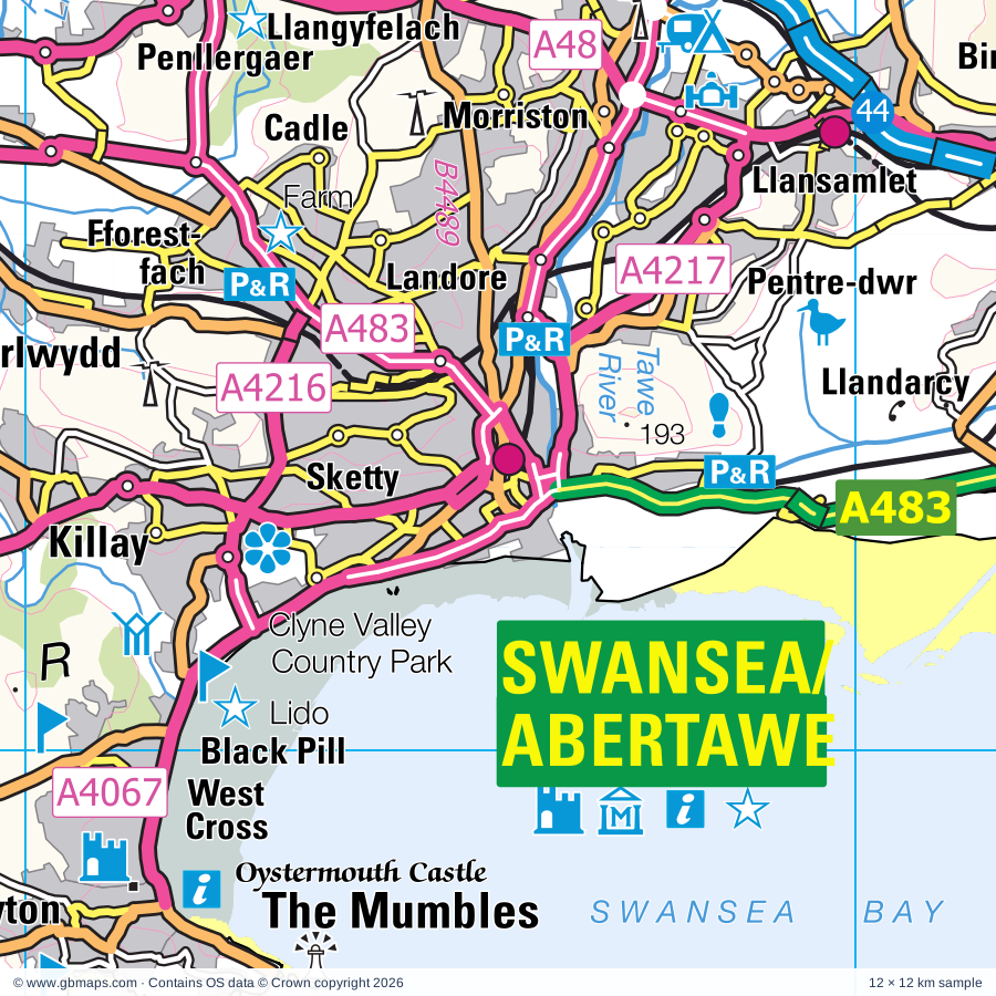
Explore the full 60 × 60 km Swansea regional road map at 1:250,000, covering Pontardawe, Ammanford, Ystradgynlais, Pontarddulais, Llandeilo. Compare the complete coverage below; a detailed PDF sample is available free.

SWANSEA & SURROUNDING AREAREGIONAL ROAD MAP
60 × 60 km · Full map previewDownload the free SVG ↓

INSIDE THE FULL 60 × 60 KM MAP

Explore the Swansea map area

1:250,000 cartography

Towns, villages & places

More mapped places (220)
  • Tairgwaith
  • Garnant
  • Glanaman
  • Brynamman
  • Llangiwg
  • Cwmllynfell
  • Ystradowen
  • Ystalyfera
  • Alltwen
  • Cilybebyll
  • Gurnos
  • Craig-cefn-parc
  • Rhos
  • Dre-fach
  • Clydach
  • Tycroes
  • Glais
  • Felindre
  • Llandybie
  • Saron
  • Crynant
  • Pentrebach
  • Seven Sisters
  • Abercraf
  • Cilfrew
  • Pen-y-groes
  • Pontlliw
  • Caehopkin
  • Milo
  • Aberdulais
  • Fforest
  • Carmel
  • Tonna
  • Hendy
  • Ffairfach
  • Gorslas
  • Clyne
  • Ynyswen
  • Grovesend
  • Penllergaer
  • Onllwyn
  • Melincourt
  • Resolven
  • Maesybont
  • Llandarcy
  • Coelbren
  • Cefneithin
  • Rhosmaen
  • Pen-y-cae
  • Bethlehem
  • Twynllanan
  • Pentreclwydau
  • Glyntawe
  • Tumble
  • Llannon
  • Llangennech
  • Cwmifor
  • Penwyllt
  • Pen-y-banc
  • Llanddeusant
  • Llangathen
  • Manordeilo
  • Tonmawr
  • Cwmgwrach
  • Drefach
  • Gowerton
  • Blaengwrach
  • Waunarlwydd
  • Felindre
  • Broad Oak
  • Baglan
  • Dryslwyn
  • Bryn
  • Llangadog
  • Pontrhydyfen
  • Salem
  • Felindre
  • Ashfield
  • Porthyrhyd
  • Sylen
  • Llanarthne
  • Dunvant
  • Pontyberem
  • Duffryn
  • Cwmafan
  • Pontneddfechan
  • Glyncorrwg
  • Llanddarog
  • Cynheidre
  • Bryn
  • Cwmdu
  • Cymer
  • Pen-clawdd
  • Llanegwad
  • Halfway
  • Llansadwrn
  • Myddfai
  • Llanwrda
  • Cwmisfael
  • Croeserw
  • Pont Henri
  • Llanfynydd
  • Rhigos
  • Llanmorlais
  • Crofty
  • Pontyates
  • Crwbin
  • Talley
  • Ystradfellte
  • Pwll
  • Nantgaredig
  • Blaengwynfi
  • Abergwynfi
  • Meinciau
  • Carway
  • Felingwmuchaf
  • Kittle
  • Ilston
  • Bishopston
  • Crai
  • Pen-y-mynydd
  • Llangyndeyrn
  • Pennard
  • Penderyn
  • Trimsaran
  • Pen-y-garn
  • Nantycaws
  • Pontantwn
  • Parkmill
  • Llywel
  • Abergorlech
  • Halfway
  • Trecastle
  • Llangynwyd
  • Blaengarw
  • Heol Senni
  • Southgate
  • Brechfa
  • Llanrhidian
  • Mynyddygarreg
  • Siloh
  • Llansawel
  • Penmaen
  • Porthyrhyd
  • Oldwalls
  • Nicholaston
  • Crugybar
  • Llandyfaelog
  • Llangunnor
  • Cwmffrwd
  • Pembrey
  • Abergwili
  • Defynnog
  • Babel
  • Landimore
  • Sennybridge
  • Gwernogle
  • Reynoldston
  • Wyndham
  • Maerdy
  • Croesyceiliog
  • Caio
  • Mawdlam
  • Cheriton
  • Cilycwm
  • Pyle
  • Penrice
  • North Cornelly
  • Bettws
  • Kenfig
  • Burry
  • Llanmadoc
  • Oxwich
  • Coytrahen
  • Llanllawddog
  • Rhydargaeau
  • Llangeinor
  • Knelston
  • Llidiad-Nenog
  • Rhydcymerau
  • Cynghordy
  • Oxwich Green
  • Bronwydd
  • Pontarsais
  • Llanddewi
  • Lewistown
  • Ffynnon-ddrain
  • Tondu
  • Brynmenyn
  • Scurlage
  • Aberkenfig
  • Llangennith
  • Blackmill
  • Trallong
  • Horton
  • Libanus
  • Sarn
  • Glynllan
  • Alltwalis
  • Bryncethin
  • Pen-y-fai
  • Llanpumsaint
  • Pilton Green
  • Glynogwr
  • Port-Eynon
  • Gwyddgrug
  • New Inn
  • Pitton
  • Middleton
  • Hendreforgan
  • Rhossili
  • Aberyscir
  • Dolgran
  • Pencader
  • Llanllwni
  • Pont-faen
  • Brynna
  • Llanilid
  • Bryncae
  • Bancyffordd

Roads across this sheet

M4, A48, A473, A474, A476, A482, A483, A484, A485, A4058, A4059, A4061, A4063, A4064, A4065, A4067, A4068, A4069, A4093, A4107, A4109, A4118, A4119, A4138

More road numbers

A4214, A4215, A4216, A4217, A4221, A4229, A4230, A4233, A4240, A4241, A4242, A4243, B4181, B4223, B4242, B4247, B4271, B4275, B4276, B4278, B4280, B4281, B4282, B4283, B4286, B4287, B4290, B4291, B4295, B4296, B4297, B4300, B4301, B4302, B4303, B4304, B4306, B4308, B4309, B4310, B4311, B4312, B4317, B4336, B4337, B4344, B4433, B4434, B4436, B4459, B4489, B4512, B4522, B4556, B4564, B4593, B4599, B4603, B4620, B4624, B4625, B5444

Rivers & waterways

Afon Afan / River Avan, Afon Aman, Afon Cennen, Afon Cothi, Afon Cynon, Afon Dafon / New Dafen River, Afon Duad, Afon Ewenny / Ewenny River, Afon Hepste, Afon Lliw, Afon Mellte, Afon Pelenna / Pelena River

More waterways

Afon Rhondda Fach, Afon Senni, Afon Twrch, Afon Tywi / River Towly, Afon Ysgir, Cilieni, Dulais, Gwendraeth Fach, Gwendraeth Fawr, Nant Bran, Neath Canal, Nedd Fechan, Ogmore River / Afon Ogwr, Ogwr Fach, Ogwr Fawr, Rhondda River / Afon Rhondda Fawr, River Loughor / Afon Llwchwr, River Neath / Afon Nedd, River Tawe, River Usk / Afon Wsyg, Swansea Canal (disused), Taf Fawr, Tennant Canal

Landmarks & landscape

Aberdulais Falls, Aberglasney Gardens, Afan Argoed Country Park, Bedford Park Country Park, Bishop's Wood Nature Reserve, Black Pill Lido, Bryngarw Country Park, Cadw, Carmarthen County Museum, Carmarthen Roman Amphitheatre, Carreg Cennen Castle, Castle Wood Field Nature Reserve, Hambury Wood Nature Reserve, BRECON BEACONS NATIONAL PARK

More named features

Cefn Coed Colliery Museum, Clyne Valley Country Park, Coity Castle, Craft Centre, Crafts Alive, Craig Cerrig Gleisiad Nature Reserve, Craig-y-nos Country Park, Crymlyn Bog Nature Reserve, Cynon Valley Museum, Dare Valley Country Park, Diamond Park, Dinefwr Castle, Dinefwr Park Country Park, Dryslwyn Castle, Dynefwr Castle, Dynevor Castle, Felindre Nature Reserve, Ffos Las Racecourse, Gelli Aur Country Park, Glyncorrwg Mountain Bike Centre, Gower Heritage Centre, Henrhyd Falls, Indoor Climbing Centre, Kenfig Nature Reserve Visitor Centre, Kenfig Pool Nature Reserve, Kidwelly Castle, Llanddeusant (Kite feeding station), Llandovery Castle (remains of), Llandovery Heritage Centre, Llyn Llech Owain Country Park, Llyn Llech Owain Country Park Visitor Centre, Loughor Castle, Margam Abbey (remains of), Margam Country Park, Melincourt Waterfall, Millennium Coastal Park, Millennium Coastal Park Visitor Centre, Mynydd Mawr Woodland Park, National Wetlands Centre Wales, Neath Abbey, Newcastle Castle, Newton House, Oxwich Castle, Oxwich National Nature Reserve, Oystermouth Castle, Pant Glas Hall, Parc Howard Museum, Parc Howard Art Gallery, Parc Slip Nature Park with Visitor Centre, Parc le Breos Burial Chamber, Paxton's Tower, Pembrey Circuit, Pembrey Country Park with Visitor Centre, Penderyn Distillery, Penderyn Distillery Visitor Centre, Penllergare Valley Woods Visitor Centre, ROMAN AMPHITHEATRE, Rare Breeds Centre, Sandy Water Park, Singleton Botanical Gardens, Solar Farm, South Wales Miners' Museum, Stones Museum, Supertrax Motor Racing Circuit (Indoor Karting), Swansea Castle, Swansea Community Farm, Swansea Museum, National Waterfront Museum, 1940s Swansea Bay, Taliesin Arts Centre, Mission Gallery, Glyn Vivian Art Gallery, Swansea Observatory, Watersports, Talley Abbey, The Gnoll Estate, The Gwili Steam Railway, The Mountain Centre, The National Botanic Garden of Wales, Tondu Iron Park, Visitor Centre, Wales Ape and Monkey Sanctuary, Weobley Castle, Whiteford Nature Reserve
Local authority & parish coverage

Wholly or partly within the full map rectangle. These boundaries are coverage information, not additional artwork layers.

  • Abertawe - SwanseaPartly within
  • Bro Morgannwg - the Vale of GlamorganPartly within
  • Castell-nedd Port Talbot - Neath Port TalbotWholly within
  • Merthyr Tudful - Merthyr TydfilPartly within
  • Pen-y-bont ar Ogwr - BridgendPartly within
  • Powys - PowysPartly within
  • Rhondda Cynon Taf - Rhondda Cynon TafPartly within
  • Sir Gaerfyrddin - CarmarthenshirePartly within
Wards & electoral divisions 168 areas
  • Aber-craf and Ystradgynlais ED
  • Aberaman ED (part)
  • Aberavon ED
  • Aberdare East ED (part)
  • Aberdare West and Llwydcoed ED (part)
  • Aberdulais ED
  • Abergwili ED
  • Aberkenfig ED
  • Allt-wen ED
  • Ammanford ED
  • Baglan ED
  • Betws ED
  • Bigyn ED
  • Bishopston ED
  • Blackmill ED
  • Blaengwrach and Glynneath West ED
  • Bon-y-maen ED
  • Brackla East Central ED (part)
  • Brackla East and Coychurch Lower ED (part)
  • Brackla West Central ED (part)
  • Brackla West ED (part)
  • Bridgend Central ED (part)
  • Briton Ferry East ED
  • Briton Ferry West ED
  • Bryn and Cwmavon ED
  • Bryn-coch North ED
  • Bryn-coch South ED
  • Brynna and Llanharan ED (part)
  • Bryntirion, laleston and Merthyr Mawr ED (part)
  • Burry Port ED
  • Bynea ED
  • Cadoxton ED
  • Caerau ED
  • Carmarthen Town North and South ED (part)
  • Carmarthen Town West ED (part)
  • Castle ED
  • Cefn-glas ED
  • Cenarth and Llangeler ED (part)
  • Cilycwm ED (part)
  • Cimla and Pelenna ED
  • Clydach ED
  • Cockett ED
  • Coedffranc Central ED
  • Coedffranc North ED
  • Coedffranc West ED
  • Coity Higher ED
  • Cornelly ED (part)
  • Cowbridge ED (part)
  • Crynant, Onllwyn and Seven Sisters ED
  • Cwarter Bach ED
  • Cwm Clydach ED
  • Cwm-twrch ED
  • Cwmbwrla ED
  • Cwmllynfell and Ystalyfera ED
  • Cyfarthfa ED (part)
  • Cymer and Glyncorrwg ED
  • Cynwyl Elfed ED (part)
  • Dafen and Felinfoel ED
  • Dunvant and Killay ED
  • Dyffryn ED
  • Elli ED
  • Fairwood ED
  • Ferndale and Maerdy ED (part)
  • Garnant ED
  • Garw Valley ED
  • Gilfach-goch ED
  • Glanamman ED
  • Glanymor ED
  • Glyn ED
  • Glynneath Central and East ED
  • Godre'r Graig ED
  • Gorseinon and Penyrheol ED
  • Gorslas ED
  • Gower ED (part)
  • Gowerton ED
  • Gwaun-Cae-Gurwen and Lower Brynamman ED
  • Gwynfi and Croeserw ED
  • Hendy ED
  • Hengoed ED
  • Hirwaun, Penderyn and Rhigos ED (part)
  • Kidwelly and St. Ishmael ED (part)
  • Landore ED
  • Llanddarog ED
  • Llandeilo ED
  • Llandovery ED (part)
  • Llandow ED (part)
  • Llandybie ED
  • Llanegwad ED
  • Llanfihangel Aberbythych ED
  • Llanfihangel-ar-Arth ED (part)
  • Llangadog ED
  • Llangennech ED
  • Llangunnor ED
  • Llangyfelach ED
  • Llangyndeyrn ED (part)
  • Llangynwyd ED
  • Llanharry ED (part)
  • Llannon ED
  • Llansamlet ED
  • Llanwrtyd Wells ED (part)
  • Llanybydder ED (part)
  • Lliedi ED
  • Llwchwr ED
  • Llwyn-y-pia ED (part)
  • Llwynhendy ED
  • Maescar and Llywel ED (part)
  • Maesteg East ED
  • Maesteg West ED
  • Manordeilo and Salem ED (part)
  • Margam and Tai-bach ED
  • Mayals ED
  • Morriston ED
  • Mumbles ED
  • Mynydd-bach ED
  • Nant-y-Moel ED
  • Neath East ED
  • Neath North ED
  • Neath South ED
  • Nottage ED (part)
  • Ogmore Vale ED
  • Pembrey ED (part)
  • Pen-clawdd ED
  • Pen-y-Fai ED
  • Pen-y-graig ED (part)
  • Pen-y-waun ED
  • Pencoed and Penprysg ED (part)
  • Penderry ED
  • Penllergaer ED
  • Pennard ED
  • Pentre ED
  • Penygroes ED
  • Pontardawe ED
  • Pontarddulais ED
  • Pontlliw and Tircoed ED
  • Pontyberem ED
  • Port Talbot ED
  • Pyle, Kenfig Hill and Cefn Cribwr ED
  • Resolven and Tonna ED
  • Rhos ED
  • Sandfields East ED
  • Sandfields West ED
  • Saron ED
  • Sketty ED
  • St. Bride's Minor and Ynysawdre ED
  • St. Clears and Llansteffan ED (part)
  • St. Thomas ED
  • Swiss Valley ED
  • Talybont-on-Usk ED (part)
  • Tawe Uchaf ED
  • Tonypandy ED
  • Tonyrefail West ED (part)
  • Townhill ED
  • Trealaw ED (part)
  • Trebanos ED
  • Treherbert ED
  • Trelech ED (part)
  • Treorchy ED
  • Trimsaran ED
  • Tycroes ED
  • Tyisha ED
  • Tylorstown and Ynyshir ED (part)
  • Uplands ED
  • Waterfront ED
  • Waunarlwydd ED
  • West Cross ED
  • Ynyscedwyn ED
  • Yscir with Honddu Isaf and Llanddew ED (part)
  • Ystrad ED (part)
Civil parishes & communities 186 areas
  • Aberaman North Community (part)
  • Aberaman South Community (part)
  • Aberavon Community
  • Aberdare East Community (part)
  • Aberdare West Community (part)
  • Abergwili Community
  • Ammanford Community
  • Baglan Bay Community
  • Baglan Community
  • Baglan Moors Community
  • Betws Community
  • Birchgrove Community
  • Bishopston Community
  • Blaengwrach Community
  • Blaenhonddan Community
  • Bonymaen Community
  • Brackla Community (part)
  • Bridgend Community (part)
  • Briton Ferry Community
  • Bronwydd Community (part)
  • Bryn Community
  • Carmarthen Community (part)
  • Castle Community
  • Cefn Cribwr Community
  • Cilybebyll Community
  • Cilycwm Community (part)
  • Clydach Community
  • Clyne and Melincourt Community
  • Cockett Community
  • Coedffranc Community
  • Coity Higher Community
  • Cornelly Community (part)
  • Coychurch Higher Community
  • Coychurch Lower Community (part)
  • Cray Community
  • Crynant Community
  • Cwm Clydach Community
  • Cwmamman Community
  • Cwmavon Community
  • Cwmbwrla Community
  • Cwmllynfell Community
  • Cyfarthfa Community (part)
  • Cymer and Glyncorrwg Community
  • Cyngor Bro Dyffryn Cennen Community
  • Cynwyl Elfed Community (part)
  • Cynwyl Gaeo Community (part)
  • Dunvant Community
  • Dyffryn Clydach Community
  • Ferndale Community (part)
  • Garw Valley Community
  • Gilfach Goch Community
  • Glyn-Tarell Community (part)
  • Glynneath Community
  • Gorseinon Community
  • Gorslas Community
  • Gowerton Community
  • Grovesend and Waungron Community
  • Gwaun-Cae-Gurwen Community
  • Gwynfi and Croeserw Community
  • Hirwaun Community (part)
  • Ilston Community
  • Kidwelly Community (part)
  • Killay Community
  • Laleston Community (part)
  • Landore Community
  • Llanarthney Community
  • Llanddarog Community
  • Llanddeusant Community
  • Llandeilo Community
  • Llandovery Community
  • Llandybie Community
  • Llandyfaelog Community (part)
  • Llanedi Community
  • Llanegwad Community
  • Llanelli Community
  • Llanelli Rural Community
  • Llanfair-ar-y-Bryn Community (part)
  • Llanfihangel Aberbythych Community
  • Llanfihangel Rhos-y-Corn Community
  • Llanfihangel-ar-Arth Community (part)
  • Llanfrynach Community (part)
  • Llanfynydd Community
  • Llangadog Community
  • Llangain Community (part)
  • Llangamarch Community (part)
  • Llangan Community (part)
  • Llangathen Community
  • Llangeler Community (part)
  • Llangennech Community
  • Llangennith, Llanmadoc and Cheriton Community (part)
  • Llangunnor Community
  • Llangyfelach Community
  • Llangyndeyrn Community
  • Llangynwyd Lower Community
  • Llangynwyd Middle Community
  • Llanharan Community (part)
  • Llanharry Community (part)
  • Llanllawddog Community
  • Llanllwni Community (part)
  • Llannon Community
  • Llanpumsaint Community (part)
  • Llanrhidian Higher Community
  • Llanrhidian Lower Community
  • Llansadwrn Community
  • Llansamlet Community
  • Llansawel Community (part)
  • Llanwrda Community
  • Llanybydder Community (part)
  • Llwchwr Community
  • Llwydcoed Community (part)
  • Llwyn-y-pia Community (part)
  • Llywel Community
  • Maerdy Community
  • Maescar Community (part)
  • Maesteg Community
  • Manordeilo and Salem Community
  • Margam Community
  • Margam Moors Community
  • Mawr Community
  • Merthyr Cynog Community (part)
  • Merthyr Mawr Community (part)
  • Morriston Community
  • Mumbles Community
  • Myddfai Community
  • Mynyddbach Community
  • Neath Community
  • Newcastle Higher Community
  • Newchurch and Merthyr Community (part)
  • Ogmore Valley Community
  • Onllwyn Community
  • Pelenna Community
  • Pembrey and Burry Port Town Community (part)
  • Pen-y-graig Community (part)
  • Pen-y-waun Community
  • Pencarreg Community (part)
  • Pencoed Community (part)
  • Penderry Community
  • Penllergaer Community
  • Penllyn Community (part)
  • Pennard Community
  • Penrice Community
  • Pentre Community
  • Pontardawe Community
  • Pontarddulais Community
  • Pontlliw and Tircoed Community
  • Pontyberem Community
  • Port Eynon Community
  • Port Talbot Community
  • Porthcawl Community (part)
  • Pyle Community
  • Quarter Bach Community
  • Resolven Community
  • Reynoldston Community
  • Rhigos Community
  • Rhossili Community (part)
  • Sandfields East Community
  • Sandfields West Community
  • Seven Sisters Community
  • Sketty Community
  • St. Bride's Minor Community
  • St. Ishmael Community (part)
  • St. Thomas Community
  • Tai-Bach Community
  • Talley Community
  • Tawe-Uchaf Community
  • Three Crosses Community
  • Tonna Community
  • Tonypandy Community
  • Tonyrefail Community (part)
  • Townhill Community
  • Trallong Community (part)
  • Trealaw Community (part)
  • Treherbert Community
  • Treorchy Community
  • Trimsaran Community
  • Tylorstown Community (part)
  • Uplands Community
  • Upper Killay Community
  • Waterfront Community
  • Waunarlwydd Community
  • Ynysawdre Community
  • Yscir Community (part)
  • Ystalyfera Community
  • Ystrad Community (part)
  • Ystradfellte Community
  • Ystradgynlais Community

Source: the GBMaps road atlas, OS Boundary-Line and postcode mapping datasets. Source editions are being checked for publication. Unmarked boundary names are wholly within the sheet; “part” means the map edge crosses the area.

Place lists are selected from the map source, not a complete gazetteer. Named features describe the cartography; visitor facilities and opening status are not verified. The free sample covers only 12 × 12 km of this larger sheet.

INSIDE YOUR DOWNLOAD

A proper road map, in useful formats

Road classifications, towns and villages, railways, rivers, landscape detail and tourist symbols, brought together in the GBMaps regional road atlas style.

PDF filePDFSVG fileSVGAdobe Illustrator AI fileAi

PDF for the finished map. SVG and layered Illustrator artwork for adapting colours, adding your own information and preparing designs.

THE FINISHED SHEET

Designed for print and presentation

Map coverage
60 × 60 km
Sample coverage
12 × 12 km
Print layout
A3 landscape · enlarged 1:250k cartography
Sheet furniture
Border, scale bar, key & north arrow

A few useful details

What changes when I select another square?

Select a surrounding square to bring it into the centre and reveal the maps around it. Each square is a different 60 × 60 km map. The preview, free sample and selected download change together. Neighbouring sheets overlap by 30 km so you can choose the coverage that suits you.

Is the free sample a vector map?

The on-page detail is an SVG. The free download is a separate 12 × 12 km PDF with a link to the full map. Please retain its copyright credits and product link when sharing it.

Can I buy a larger combined map?

These downloads are individual ready-made sheets. Contact GBMaps if you need a larger combined area.

FREE PDF SAMPLE

Your free map sample

Your free 12 × 12 km sample includes a link back to this map, so you can return for the full area whenever you need it.

Download free PDF sample ↓

Get your Swansea map

Map download bundle

£24.00including VATOne payment

Pay securely

One payment. Your map stays open.

Your map download

Your map files

Preparing your download…

Checking your private download link…

Your map downloads

Already bought a map?

Find the downloads from your purchases.

Enter the email address you used at checkout. We’ll email you a private link to your available map downloads.