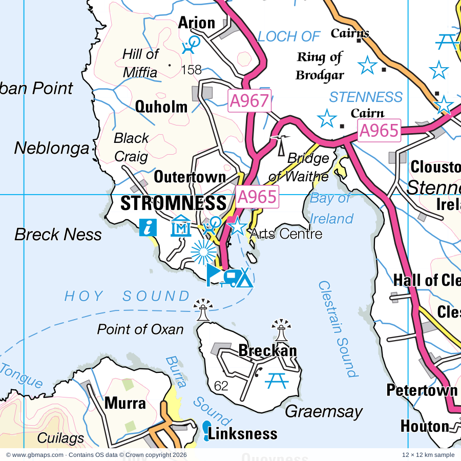
Stromness regional road map. Full 60 × 60 km PDF, SVG and Illustrator files, with a free PDF sample.

GBMAPS.COM

Stromness Regional Road Map

Call Us Now for Help01751 473136

GREAT BRITAIN ROAD ATLAS · 1:250,000 GB-330-1020

Stromness & surrounding area

Explore the full 60 × 60 km Stromness regional road map at 1:250,000, covering Stromness, Kirkwall, Dounby, Mirbister, Beaquoy. Compare the complete coverage below; a detailed PDF sample is available free.

STROMNESS & SURROUNDING AREAREGIONAL ROAD MAP
60 × 60 km · Full map previewDownload the free SVG ↓

INSIDE THE FULL 60 × 60 KM MAP

Explore the Stromness map area

1:250,000 cartography

Towns, villages & places

  • Stromness
  • Kirkwall
  • Dounby
  • Mirbister
  • Beaquoy
  • Skeabrae
  • Greeny
  • Netherbrough
  • Tenston
  • Bimbister
  • Twatt
  • Hestwall
  • Kirbuster
  • Voy
  • Northdyke
  • Settiscarth
  • Marwick
  • Norseman
More mapped places (59)
  • Yesnaby
  • Quholm
  • The Barony
  • Finstown
  • Isbister
  • Clouston
  • Heddle
  • Hackland
  • Grimbister
  • Ireland
  • Tingwall
  • Gorseness
  • Outertown
  • Frotoft
  • Clestrain
  • Kirbister
  • Petertown
  • Brinian
  • Hobbister
  • Houton
  • Wasbister
  • Greenigoe
  • Hoy
  • Sourin
  • Quoyness
  • Balfour
  • Rackwick
  • Yinstay
  • St Mary's
  • Lyness
  • Rinnigill
  • West Side
  • Foubister
  • Crockness
  • Backaland
  • Hillside
  • Midbea
  • Little Ayre
  • Northtown
  • Rapness
  • Hoxa
  • Veness
  • Wyng
  • Hackness
  • Longhope
  • Burray Village
  • Cornquoy
  • Southtown
  • Quindry
  • Herston
  • Skelwick
  • Braehead
  • Broughton
  • Grimness
  • Pierowall
  • Widewall
  • Eastside
  • Calfsound
  • Aikers

Roads across this sheet

A960, A961, A962, A963, A964, A965, A966, A967, A986, B9036, B9042, B9043, B9044, B9045, B9046, B9047, B9048, B9049, B9050, B9051, B9052, B9053, B9054, B9055

More road numbers

B9056, B9057, B9058, B9059, B9064, B9065, B9066, B9067, B9148

Rivers & waterways

Burn of Hillside, Burn of Ore, Graemeshall Burn, Lyrawa Burn, Pegal Burn, South Burn

Landmarks & landscape

Aurora, Barnhouse Neolithic Village (Restored), Barony Mills, Belgrath Bodhrams, Berriedale Wood, Broch, Broch of Gurness, Brough Head Settlement, Brough of Deerness, Burroughston Broch, Bursay Moors Nature Reserve, Cairn

More named features

Cairns, Carrick House, Celtian, Click Mill, Corrigall Farm Museum, Covenanter's Memorial, Cubbie Roo's Castle, Cuween Chambered Cairn, David Holmes Ceramics, Dwarfie Stone, Earl's Palace, Eynhallow Monastery, Fluke Jewellery, Fursbreck Pottery, Grain Earth-House, Grain Earth-House (Souterrain), Hackness Martello Tower, Highland Park Distillery, Hobbister Hill Nature Reserve, Hoy Nature Reserve, Italian Chapel, Kierfiold House, Kierfiold House Gardens, Kirbuster Farm & Folk Museum, Kitchener Memorial, Knowe of Yarso Chambered Cairn, Blackhammer Chambered Cairn, Knowe of Yarso Chambered Cairn, Blackhammer Chambered Cairn, Taversoe Tuick Chambered Cairn, Lady Kirk (church), Maeshowe, Maeshowe (World Heritage Site), Marwick Head Nature Reserve, Mid Howe Broch, Mid Howe Brock, Mid Howe Chambered Cairn, Mill Dam Nature Reserve, Mine Howe, Mull Head Nature Reserve, Noltland Castle, Old Man of Hoy, Onziebust Nature Reserve, Orkney Fossil & Vintage Centre, Orkney Marine Life Aquarium, Orkney Stained Glass, Orkney Wireless Museum, Orkneyinga, Ortak Jewellery Visitor Centre, Palace, Photographic Insights, Pier Arts Centre, Rackwick Folk Museum, Rendall Dovecot, Rennibister Earth House (Souterrain), Ring of Brodgar (World Heritage Site), Rousay Heritage Centre, Scapa Flow Visitor Centre and Museum, Scarpa Distillery, Shapinsay Heritage Centre, Sheila Fleet, Skaill House, Skara Brae (World Heritage Site), Visitor Centre, Skara Brae Prehistoric Village, St Magnus Cathedral, St Magnus Church, St Mary's Chapel, St Nicholas' Church & Orphir-Earl's Bu, St Nicholas' Church & Orphirs-Earl's Bu, Stephane Jaeger, Stewart Moar Jewellery, Stomness Museum, Stone of Setter, Stones, Stones of Stenness (World Heritage Site), Tate & Style, The Bishops Palace and Earls Palace, The Gloup, The Loons Nature Reserve, The Orkney Brewery, The Woolshed, The Workshop, Traditional Orkney Crafts, Trumland House, Trumland Nature Reserve, Unstan Chambered Cairn, Westray Heritage Centre, Westray Knitters, Westside Church, Wideford Hill, Wyre Heritage Centre
Local authority & parish coverage

Wholly or partly within the full map rectangle. These boundaries are coverage information, not additional artwork layers.

  • Orkney IslandsPartly within
Wards & electoral divisions 6 areas
  • East Mainland, South Ronaldsay and Burray Ward (part)
  • Kirkwall East Ward
  • Kirkwall West and Orphir Ward
  • North Isles Ward (part)
  • Stromness and South Isles Ward (part)
  • West Mainland Ward (part)
Civil parishes & communities 0 areas

    Source: the GBMaps road atlas, OS Boundary-Line and postcode mapping datasets. Source editions are being checked for publication. Unmarked boundary names are wholly within the sheet; “part” means the map edge crosses the area.

    Place lists are selected from the map source, not a complete gazetteer. Named features describe the cartography; visitor facilities and opening status are not verified. The free sample covers only 12 × 12 km of this larger sheet.

    INSIDE YOUR DOWNLOAD

    A proper road map, in useful formats

    Road classifications, towns and villages, railways, rivers, landscape detail and tourist symbols, brought together in the GBMaps regional road atlas style.

    PDF filePDFSVG fileSVGAdobe Illustrator AI fileAi

    PDF for the finished map. SVG and layered Illustrator artwork for adapting colours, adding your own information and preparing designs.

    THE FINISHED SHEET

    Designed for print and presentation

    Map coverage
    60 × 60 km
    Sample coverage
    12 × 12 km
    Print layout
    A3 landscape · enlarged 1:250k cartography
    Sheet furniture
    Border, scale bar, key & north arrow

    A few useful details

    What changes when I select another square?

    Select a surrounding square to bring it into the centre and reveal the maps around it. Each square is a different 60 × 60 km map. The preview, free sample and selected download change together. Neighbouring sheets overlap by 30 km so you can choose the coverage that suits you.

    Is the free sample a vector map?

    The on-page detail is an SVG. The free download is a separate 12 × 12 km PDF with a link to the full map. Please retain its copyright credits and product link when sharing it.

    Can I buy a larger combined map?

    These downloads are individual ready-made sheets. Contact GBMaps if you need a larger combined area.

    FREE PDF SAMPLE

    Your free map sample

    Your free 12 × 12 km sample includes a link back to this map, so you can return for the full area whenever you need it.

    Download free PDF sample ↓

    Get your Stromness map

    Map download bundle

    £24.00including VATOne payment

    Pay securely

    One payment. Your map stays open.

    Your map download

    Your map files

    Preparing your download…

    Checking your private download link…

    Your map downloads

    Already bought a map?

    Find the downloads from your purchases.

    Enter the email address you used at checkout. We’ll email you a private link to your available map downloads.