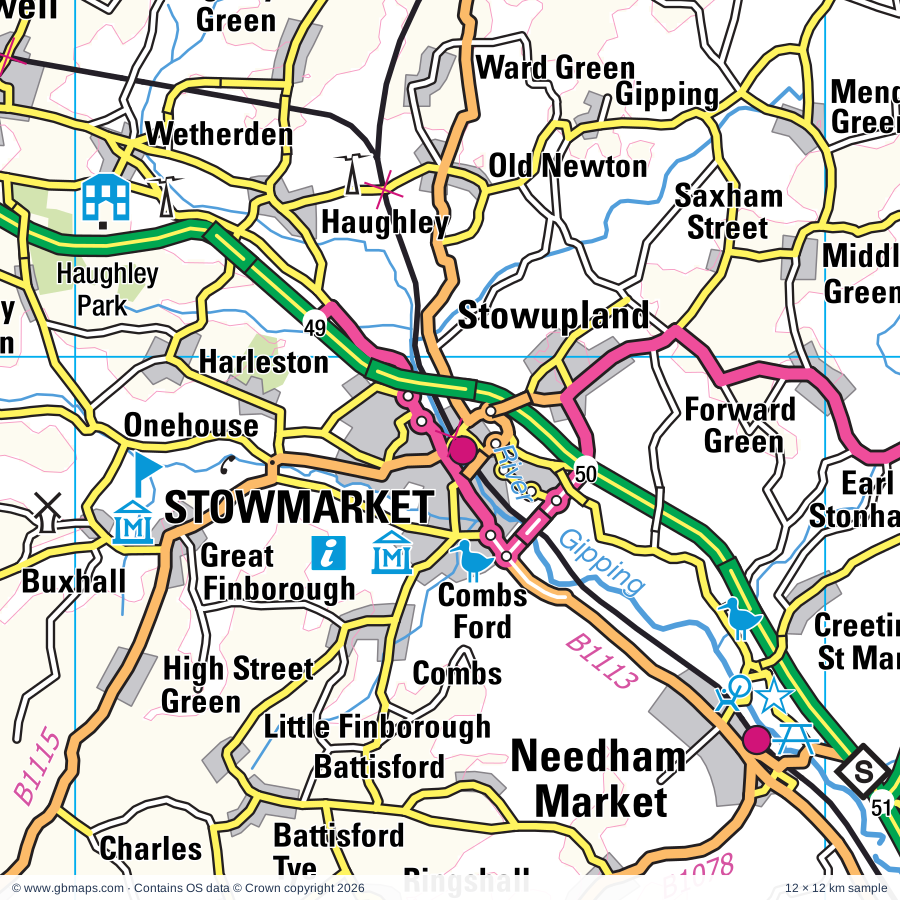
Stowmarket regional road map. Full 60 × 60 km PDF, SVG and Illustrator files, with a free PDF sample.

GBMAPS.COM

Stowmarket Regional Road Map

Call Us Now for Help01751 473136

GREAT BRITAIN ROAD ATLAS · 1:250,000 GB-600-0270

Stowmarket & surrounding area

Explore the full 60 × 60 km Stowmarket regional road map at 1:250,000, covering Stowmarket, Eye, Diss, Bury St Edmunds, Thetford. Compare the complete coverage below; a detailed PDF sample is available free.

STOWMARKET & SURROUNDING AREAREGIONAL ROAD MAP
60 × 60 km · Full map previewDownload the free SVG ↓

INSIDE THE FULL 60 × 60 KM MAP

Explore the Stowmarket map area

1:250,000 cartography

Towns, villages & places

More mapped places (352)
  • Badwell Ash
  • Long Thurlow
  • Langham
  • Hunston
  • Upthorpe
  • Wattisfield
  • Stowlangtoft
  • Stanton
  • Wyverstone
  • Westhorpe
  • Hepworth
  • Bacton
  • Norton
  • Candle Street
  • Elmswell
  • Ixworth
  • Cotton
  • Bardwell
  • Finningham
  • Rickinghall
  • Pakenham
  • Wetherden
  • Hinderclay
  • Barningham
  • Botesdale
  • Gislingham
  • Ward Green
  • Tostock
  • Woolpit
  • Haughley
  • Thelnetham
  • Drinkstone
  • Redgrave
  • Beyton
  • Hopton
  • Old Newton
  • Blo' Norton
  • Thurston
  • Sapiston
  • Gipping
  • Harleston
  • Troston
  • Mellis
  • Hessett
  • Wortham
  • Onehouse
  • Rattlesden
  • Gasthorpe
  • Mendlesham
  • Thwaite
  • Garboldisham
  • Blackthorpe
  • Buxhall
  • Rougham
  • Stowupland
  • Yaxley
  • Gedding
  • Thrandeston
  • Wetheringsett
  • Ampton
  • Braiseworth
  • Rushbrooke
  • Rushford
  • Bressingham
  • Euston
  • Felsham
  • Thorndon
  • Timworth
  • Combs
  • Palgrave
  • Fersfield
  • Roydon
  • Ingham
  • Brome
  • Brettenham
  • Little Finborough
  • Sicklesmere
  • Stuston
  • Occold
  • Barnham
  • Mickfield
  • Rishangles
  • Brettenham
  • Culford
  • Bridgham
  • Great Green
  • Kenninghall
  • Battisford
  • Nowton
  • Hengrave
  • Wordwell
  • Aspall
  • Scole
  • Shelfanger
  • Ringshall
  • Hawstead
  • Oakley
  • Cockfield
  • Bedingfield
  • Quidenham
  • Stanningfield
  • Westley
  • Barking
  • Wattisham
  • Flempton
  • Debenham
  • Redlingfield
  • Hitcham
  • Billingford
  • Burston
  • Winfarthing
  • Horringer
  • Barking Tye
  • Hoxne
  • Banham
  • Southolt
  • Kenton
  • Pettaugh
  • Crowfield
  • Thelveton
  • Larling
  • Denham
  • Kettlebaston
  • Willisham Tye
  • Winston
  • Shimpling
  • Wilby
  • Eccles Road
  • Illington
  • Whepstead
  • Bildeston
  • Coddenham
  • Risby
  • Willisham
  • Elveden
  • Lawshall
  • Lackford
  • Baylham
  • Gosbeck
  • Dickleburgh
  • Little Saxham
  • Snetterton
  • Athelington
  • Croxton
  • Horham
  • Gissing
  • Naughton
  • Offton
  • Framsden
  • Chelsworth
  • Alpheton
  • East Wretham
  • Stonebridge
  • Hemingstone
  • Bedfield
  • Lavenham
  • Helmingham
  • Worlingworth
  • Ashbocking
  • Syleham
  • Somersham
  • Puddledock
  • Shropham
  • Brockley
  • Shimpling
  • Icklingham
  • Brockdish
  • Semer
  • Whatfield
  • Stradbroke
  • Burthorpe
  • Barham
  • Wingfield
  • Chevington
  • Rushall
  • Claydon
  • Cavenham
  • Tibenham
  • Rede
  • Elmsett
  • Earl Soham
  • Milden
  • Bridge Street
  • Wilby
  • Hartest
  • Chedburgh
  • Ashbocking
  • Tannington
  • Barrow
  • Henley
  • Breckles
  • Hargate
  • Flowton
  • Pixey Green
  • Cretingham
  • Gibraltar
  • Otley
  • Lindsey
  • Hargrave
  • Somerton
  • Swilland
  • Boxted
  • Crown Corner
  • Saxtead
  • Aldham
  • Needham
  • Higham
  • Denham
  • Burstallhill
  • Depden
  • Stanstead
  • Akenham
  • Kersey
  • Brundish Street
  • Hawkedon
  • Aslacton
  • Ashfield Green
  • Tuddenham
  • Witnesham
  • Weybread
  • Besthorpe
  • Monewden
  • Bunwell
  • Brandeston
  • Bramford
  • Brundish
  • Burstall
  • Fressingfield
  • Ousden
  • Bush Green
  • Starston
  • Upsher Green
  • Thompson
  • Westerfield
  • Stansfield
  • West Tofts
  • Clopton
  • Sproughton
  • Hintlesham
  • Glemsford
  • Clopton Green
  • Hoo
  • Herringswell
  • Wacton
  • Caston
  • Tacolneston
  • Dennington
  • Wangford
  • Edwardstone
  • Groton
  • Kettleburgh
  • Barton Mills
  • Gazeley
  • Northacre
  • Dalham
  • Eriswell
  • Wickham Street
  • Debach
  • North Green
  • Liston
  • Kentford
  • Charsfield
  • Chattisham
  • Grundisburgh
  • Denston
  • Weeting
  • Wickhambrook
  • Griston
  • Hardwick
  • Burgh
  • Boxford
  • Laxfield
  • Letheringham
  • Mendham
  • Shelton
  • Foxearth
  • Washbrook
  • Merton
  • Lidgate
  • Newton
  • Stradishall
  • Cavendish
  • Dallinghoo
  • Suton
  • Ashwellthorpe
  • Easton
  • Playford
  • Copdock
  • Tharston
  • Mundford
  • Pentlow
  • Borley
  • Metfield
  • Ickburgh
  • Fundenhall
  • Lakenheath
  • Great Bealings
  • Morningthorpe
  • Poslingford
  • Wortwell
  • Belstead
  • Hasketon
  • Alburgh
  • Fritton
  • Bredfield
  • Hapton
  • Upend
  • Silfield
  • Homersfield
  • Cowlinge
  • Wreningham
  • Tasburgh
  • Pettistree
  • Cranwich
  • Wherstead
  • Bodney
  • Flordon
  • Denton
  • Hundon
  • Bulmer
  • Martlesham
  • Melton
  • Hempnall
  • Ufford
  • Topcroft Street
  • Bracon Ash
  • Topcroft
  • Feltwell
  • Newton Flotman
  • Barnardiston
  • Ovington
  • Northwold
  • Methwold
  • Brightwell
  • Bucklesham
  • Foulden
  • Brookville
  • Ashen
  • Kedington
  • Woodton
  • Waldringfield
  • Methwold Hythe
  • Shotesham
  • Newbourne
  • Wixoe
  • Ridgewell
  • Hemley
  • Howe
  • Brooke
  • Whittington
  • Birdbrook
  • Stoke Ferry

Roads across this sheet

A11, A12, A131, A134, A137, A140, A143, A1017, A1022, A1065, A1066, A1071, A1075, A1088, A1092, A1101, A1120, A1141, A1152, A1156, A1189, A1214, A1302, A1308

More road numbers

B1054, B1061, B1062, B1063, B1064, B1065, B1066, B1067, B1070, B1071, B1073, B1075, B1077, B1078, B1079, B1083, B1085, B1102, B1106, B1107, B1108, B1111, B1112, B1113, B1115, B1116, B1117, B1118, B1119, B1120, B1123, B1132, B1134, B1172, B1332, B1386, B1438, B1456, B1458, B1506, B1508, B1527

Rivers & waterways

Little Ouse River, River Alde, River Blyth, River Brett, River Chet, River Colne, River Deben, River Dove, River Gipping, River Kennett, River Lark, River Stour

More waterways

River Thet, River Waveney, River Wissey

Landmarks & landscape

100th Bomb Group Memorial Museum (USAF), Alder Carr Farm, Ampton Point to Point Racecourse, Ancient House Museum, Charles Burrell Museum, Banham Zoo, Bardwell Windmill, Baylham House Rare Breeds Farm, Bradfield Woods Nature Reserve, Bramford Meadows Nature Reserve, Brandon Country Park, Brandon Country Visitor Centre, Brandon Heritage Museum

More named features

Brook Farm Museum, Burston Strike School, Bury St Edmunds Abbey, Buttrums Mill, Castle (rems of), Cavenham Heath Nature Reserve, Christchurch Mansion, Ipswich Museum, ARP Shelter Museum, Ipswich Transport Museum, Church of the Holy Sepulchre, Clare Ancient House Museum, Clare Castle Country Park, Clare Priory (Rems of), Clare Priory (remains of), Classic Rose Centre, Combs Wood Nature Reserve, Cotton Mechanical Music Museum & Bygones, Creeting St Mary Windmill, Denham Castle, Desert Rats Memorial, Diss Museum, East Wretham Heath Nature Reserve, Easton Farm Park, Euston Hall, Euston Watermill, Eye Castle, Fen Alder Carr Nature Reserve, Forncett Industrial Steam Museum, Framlingham Castle, Gainsborough's House, Garboldisham Windmill, Gifford's Hall Vineyard and Sweet Pea Centre, Go Ape Thetford, Grimes Graves Flint Mines, Grimes Graves Flint Mines & Visitor centre, Groton Wood Nature Reserve, Hadleigh Town Hall, Hall Farm, Harleston Town Museum, Haughley Park, Helmingham Hall, Helmingham Hall Gardens, High Lodge Forest Centre, Go Ape Thetford, Iceni Brewery, Ickworth House, Jimmys Farm, Kentwell Hall, Kilverstone Hall, Knettishall Heath Country Park, Lackford Wildfowl Nature Reserve, Lavenham The Guildhall of Corpus Christi, Lavenham Walk Nature Reserve, Laxfield & District Museum, Little Blakenham Woodland Garden, Lynford Arboretum, Martlesham Heath Aviation Museum, Meadow Farm Solar Farm, Melford Hall, Mid-Suffolk Light Railway Museum, Mildenhall and District Museum, Museum of East Anglia Life, Newbourne Springs Nature Reserve, Nowton Country Park, Old Buckenham Windmill, Orwell Country Park, Otley Hall, Otley Hall Gardens, Pakenham Water Mill, Priory, Reaches Farm Solar Farm, Rougham Control Tower Museum, Saxtead Green Post Mill, Snetterton Motor Racing Circuit, Solar Farm, St Georges Distillery, St James Chapel, Stanton Post Mill, Starston Windpump, Stonham Barns Craft Centre, Suffolk Owl Sanctuary, Suffolk Regimental Museum, Moyse's Hall Museum, The Malthouse Project, Suffolk Ski Centre, Sutton Hoo Tumuli, Sutton Hoo Visitor Centre, The Dell Garden, The Priory, The Little Hall, Theatre Royal, Greene King Brewery, Thelnetham Windmill, Thetford Church of the Holy Sepulchre, Thetford Priory, Thetford Warren Lodge, Trinity Park Showground, Visitor Centre, Wattisham Airfield Museum, Waveney Valley Railway and Nursery Line (Tourist Railway), Weeting Castle, Weeting Heath Nature Reserve, West Stow Anglo-Saxon Village, Lackford Lakes Visitor Centre, West Stow Country Park, Wolsey Art Gallery, Waterfront Heritage Centre, Wolves Wood Nature Reserve, Woodbridge Museum, Shire Horse Museum, Woodbridge Tide Mill, Woolpit & District Museum, Wyken Hall, Wyken Vineyard
Local authority & parish coverage

Wholly or partly within the full map rectangle. These boundaries are coverage information, not additional artwork layers.

  • Babergh DistrictPartly within
  • Braintree DistrictPartly within
  • Breckland DistrictPartly within
  • East Cambridgeshire DistrictPartly within
  • East Suffolk DistrictPartly within
  • Ipswich DistrictWholly within
  • King's Lynn and West Norfolk DistrictPartly within
  • Mid Suffolk DistrictPartly within
  • South Norfolk DistrictPartly within
  • West Suffolk DistrictPartly within
Wards & electoral divisions 145 areas
  • Abbeygate Ward
  • Alexandra Ward
  • All Saints & Wayland Ward (part)
  • Ashill Ward (part)
  • Assington Ward (part)
  • Attleborough Burgh & Haverscroft Ward
  • Attleborough Queens & Besthorpe Ward
  • Bacton Ward
  • Bardwell Ward
  • Barningham Ward
  • Barrow Ward
  • Battisford & Ringshall Ward
  • Beck Vale, Dickleburgh & Scole Ward
  • Bedingfeld Ward (part)
  • Bixley Ward
  • Blakenham Ward
  • Box Vale Ward (part)
  • Bramford Ward
  • Brandon Central Ward
  • Brandon East Ward
  • Brandon West Ward
  • Bressingham & Burston Ward
  • Brett Vale Ward (part)
  • Bridge Ward
  • Brooke Ward (part)
  • Bumpstead Ward (part)
  • Bungay & Wainford Ward (part)
  • Bunwell Ward
  • Carlford & Fynn Valley Ward
  • Castle Hill Ward
  • Chadacre Ward
  • Chedburgh & Chevington Ward
  • Chilton Ward
  • Clare, Hundon & Kedington Ward (part)
  • Claydon & Barham Ward
  • Combs Ford Ward
  • Copdock & Washbrook Ward (part)
  • Deben Ward (part)
  • Debenham Ward
  • Diss & Roydon Ward
  • Ditchingham & Earsham Ward (part)
  • Eastgate Ward
  • Elmswell & Woolpit Ward
  • Eye Ward
  • Feltwell Ward (part)
  • Fordham & Isleham Ward (part)
  • Forest Ward
  • Forncett Ward
  • Framlingham Ward (part)
  • Fressingfield Ward (part)
  • Gainsborough Ward
  • Gipping Ward
  • Gislingham Ward
  • Great Cornard Ward (part)
  • Guiltcross Ward
  • Hadleigh North Ward
  • Hadleigh South Ward
  • Harleston Ward
  • Harling & Heathlands Ward
  • Haughley, Stowupland & Wetherden Ward
  • Hempnall Ward
  • Hingham & Deopham Ward (part)
  • Holywells Ward
  • Horringer Ward
  • Hoxne & Worlingworth Ward
  • Iceni Ward (part)
  • Ixworth Ward
  • Kelsale & Yoxford Ward (part)
  • Kentford & Moulton Ward (part)
  • Kesgrave Ward
  • Lakenheath Ward (part)
  • Lavenham Ward
  • Long Melford Ward
  • Manor Ward (part)
  • Martlesham & Purdis Farm Ward
  • Melton Ward
  • Mendlesham Ward
  • Methwold Ward (part)
  • Mildenhall Great Heath Ward
  • Mildenhall Kingsway & Market Ward
  • Mildenhall Queensway Ward (part)
  • Minden Ward
  • Moreton Hall Ward
  • Mulbarton & Stoke Holy Cross Ward (part)
  • Needham Market Ward
  • Newton Flotman Ward (part)
  • North West Cosford Ward
  • Onehouse Ward
  • Orwell & Villages Ward (part)
  • Orwell Ward (part)
  • Pakenham & Troston Ward
  • Palgrave Ward
  • Poringland, Framinghams & Trowse Ward (part)
  • Priory Heath Ward
  • Rattlesden Ward
  • Rickinghall Ward
  • Risby Ward
  • Rougham Ward
  • Rushmere St. Andrew Ward
  • Rushmere Ward
  • Saham Toney Ward (part)
  • South East Cosford Ward
  • South Wymondham Ward (part)
  • Southgate Ward
  • Sprites Ward
  • Sproughton & Pinewood Ward
  • St. John's Ward
  • St. Margaret's Ward
  • St. Olaves Ward
  • St. Peter's Ward
  • Stanton Ward
  • Stoke Park Ward
  • Stonham Ward
  • Stour Valley North Ward (part)
  • Stour Valley South Ward (part)
  • Stow Thorney Ward
  • Stradbroke & Laxfield Ward (part)
  • Stratton Ward
  • Sudbury North East Ward
  • Sudbury North West Ward
  • Sudbury South East Ward
  • Sudbury South West Ward
  • The Buckenhams & Banham Ward
  • The Fornhams & Great Barton Ward
  • The Rows Ward (part)
  • Thetford Boudica Ward
  • Thetford Burrell Ward
  • Thetford Castle Ward
  • Thetford Priory Ward
  • Thurston Ward
  • Tollgate Ward
  • Walsham-le-Willows Ward
  • Watton Ward (part)
  • Westgate Ward
  • Westgate Ward
  • Whepstead & Wickhambrook Ward
  • Whitehouse Ward
  • Whitton Ward
  • Wickham Market Ward (part)
  • Wicklewood Ward (part)
  • Wissey Ward (part)
  • Withersfield Ward (part)
  • Woodbridge Ward
  • Woodditton Ward (part)
  • Yeldham Ward (part)
Civil parishes & communities 468 areas
  • Acton CP
  • Akenham CP
  • Alburgh CP
  • Aldham CP
  • Alpheton CP
  • Ampton CP
  • Ashbocking CP
  • Ashen CP
  • Ashfield cum Thorpe CP
  • Ashley CP (part)
  • Ashwellthorpe and Fundenhall CP
  • Aslacton CP
  • Aspall CP
  • Assington CP (part)
  • Athelington CP
  • Attleborough CP
  • Bacton CP
  • Badingham CP (part)
  • Badley CP
  • Badwell Ash CP
  • Banham CP
  • Bardwell CP
  • Barham CP
  • Barking CP
  • Barnardiston CP (part)
  • Barnham CP
  • Barningham CP
  • Barrow CP
  • Barton Mills CP
  • Battisford CP
  • Baylham CP
  • Beck Row, Holywell Row and Kenny Hill CP (part)
  • Bedfield CP
  • Bedingfield CP
  • Bedingham CP (part)
  • Belchamp Otten CP (part)
  • Belchamp St. Paul CP
  • Belchamp Walter CP (part)
  • Belstead CP (part)
  • Bentley CP (part)
  • Bergh Apton CP (part)
  • Besthorpe CP
  • Beyton CP
  • Bildeston CP
  • Birdbrook CP (part)
  • Blo' Norton CP
  • Borley CP
  • Botesdale CP
  • Boulge CP
  • Boxford CP (part)
  • Boxted CP
  • Bracon Ash CP (part)
  • Bradfield Combust with Stanningfield CP
  • Bradfield St. Clare CP
  • Bradfield St. George CP
  • Braiseworth CP
  • Bramford CP
  • Brandeston CP
  • Brandon CP
  • Bredfield CP
  • Brent Eleigh CP
  • Bressingham CP
  • Brettenham CP
  • Brettenham CP
  • Bridgham CP
  • Brightwell CP
  • Brockdish CP
  • Brockley CP
  • Brome and Oakley CP
  • Bromeswell CP (part)
  • Brooke CP (part)
  • Brundish CP
  • Bucklesham CP
  • Bulmer CP (part)
  • Bunwell CP
  • Burgate CP
  • Burgh CP
  • Burstall CP
  • Burston and Shimpling CP
  • Bury St. Edmunds CP
  • Buxhall CP
  • Carbrooke CP (part)
  • Carleton Rode CP
  • Caston CP
  • Cavendish CP
  • Cavenham CP
  • Charsfield CP
  • Chattisham CP
  • Chedburgh CP
  • Chelsworth CP
  • Chevington CP
  • Chilton CP
  • Clare CP
  • Claydon CP
  • Clopton CP
  • Cockfield CP
  • Coddenham CP
  • Combs CP
  • Coney Weston CP
  • Copdock and Washbrook CP (part)
  • Cotton CP
  • Cowlinge CP (part)
  • Cranwich CP
  • Cratfield CP (part)
  • Creeting St. Mary CP
  • Creeting St. Peter CP
  • Cretingham CP
  • Crowfield CP
  • Croxton CP
  • Culford CP
  • Culpho CP
  • Dalham CP
  • Dallinghoo CP
  • Darmsden CP
  • Debach CP
  • Debenham CP
  • Denham CP
  • Denham CP
  • Dennington CP (part)
  • Denston CP
  • Denton CP
  • Deopham CP (part)
  • Depden CP
  • Dickleburgh and Rushall CP
  • Didlington CP
  • Diss CP
  • Drinkstone CP
  • Earl Soham CP
  • Earl Stonham CP
  • Earsham CP (part)
  • Easton CP
  • Edwardstone CP
  • Elmsett CP
  • Elmswell CP
  • Elveden CP
  • Eriswell CP
  • Euston CP
  • Eye CP
  • Fakenham Magna CP
  • Falkenham CP (part)
  • Felsham CP
  • Feltwell CP (part)
  • Finningham CP
  • Flempton CP
  • Flixton CP (part)
  • Flordon CP
  • Flowton CP
  • Forncett CP
  • Fornham All Saints CP
  • Fornham St. Genevieve CP
  • Fornham St. Martin CP
  • Foulden CP (part)
  • Foxearth CP
  • Foxhall CP
  • Framlingham CP (part)
  • Framsden CP
  • Fressingfield CP (part)
  • Freston CP (part)
  • Garboldisham CP
  • Gazeley CP
  • Gedding CP
  • Gipping CP
  • Gislingham CP
  • Gissing CP
  • Glemsford CP
  • Gosbeck CP
  • Great Ashfield CP
  • Great Barton CP
  • Great Bealings CP
  • Great Blakenham CP
  • Great Bricett CP
  • Great Cornard CP (part)
  • Great Cressingham CP (part)
  • Great Ellingham CP
  • Great Finborough CP
  • Great Livermere CP
  • Great Moulton CP
  • Great Thurlow CP (part)
  • Great Waldingfield CP
  • Great Whelnetham CP
  • Great Wratting CP (part)
  • Griston CP (part)
  • Groton CP
  • Grundisburgh CP
  • Hacheston CP (part)
  • Hadleigh CP
  • Hargrave CP
  • Harleston CP
  • Harling CP
  • Hartest CP
  • Hasketon CP
  • Haughley CP
  • Hawkedon CP
  • Hawstead CP
  • Hedenham CP (part)
  • Helmingham CP
  • Hemingstone CP
  • Hemley CP
  • Hempnall CP
  • Hengrave CP
  • Henley CP
  • Hepworth CP
  • Herringswell CP (part)
  • Hessett CP
  • Heywood CP
  • Higham CP
  • Hilborough CP (part)
  • Hinderclay CP
  • Hingham CP (part)
  • Hintlesham CP
  • Hitcham CP
  • Hockham CP
  • Hockwold cum Wilton CP (part)
  • Honington CP
  • Hoo CP
  • Hopton CP
  • Horham CP
  • Horringer CP
  • Howe CP (part)
  • Hoxne CP
  • Hundon CP
  • Hunston CP
  • Ickburgh CP
  • Icklingham CP
  • Ickworth CP
  • Ingham CP
  • Ixworth CP
  • Ixworth Thorpe CP
  • Kedington CP (part)
  • Kennett CP (part)
  • Kenninghall CP
  • Kentford CP (part)
  • Kenton CP
  • Kersey CP
  • Kesgrave CP
  • Kettlebaston CP
  • Kettleburgh CP
  • Kilverstone CP
  • Kirstead CP (part)
  • Kirtling CP (part)
  • Kirton CP (part)
  • Knettishall CP
  • Lackford CP
  • Lakenheath CP (part)
  • Langham CP
  • Lavenham CP
  • Lawshall CP
  • Laxfield CP (part)
  • Layham CP (part)
  • Letheringham CP
  • Levington CP (part)
  • Lidgate CP
  • Lindsey CP
  • Liston CP
  • Little Bealings CP
  • Little Blakenham CP
  • Little Bradley CP (part)
  • Little Cressingham CP (part)
  • Little Ellingham CP (part)
  • Little Finborough CP
  • Little Livermere CP
  • Little Thurlow CP (part)
  • Little Waldingfield CP
  • Little Whelnetham CP
  • Little Wratting CP (part)
  • Little Yeldham CP (part)
  • Long Melford CP
  • Long Stratton CP
  • Lynford CP
  • Market Weston CP
  • Martlesham CP
  • Mellis CP
  • Melton CP
  • Mendham CP
  • Mendlesham CP
  • Merton CP (part)
  • Metfield CP (part)
  • Methwold CP (part)
  • Mickfield CP
  • Middleton CP (part)
  • Milden CP
  • Mildenhall High CP (part)
  • Monewden CP
  • Monk Soham CP
  • Monks Eleigh CP
  • Morley CP (part)
  • Morningthorpe and Fritton CP
  • Moulton CP (part)
  • Mulbarton CP (part)
  • Mundford CP
  • Nacton CP (part)
  • Nedging-with-Naughton CP
  • Needham CP
  • Needham Market CP
  • Nettlestead CP
  • New Buckenham CP
  • Newbourne CP
  • Newton CP (part)
  • Newton Flotman CP (part)
  • North Lopham CP
  • Northwold CP (part)
  • Norton CP
  • Nowton CP
  • Occold CP
  • Offton CP
  • Old Buckenham CP
  • Old Newton with Dagworth CP
  • Onehouse CP
  • Otley CP
  • Ousden CP
  • Ovington CP
  • Oxborough CP (part)
  • Pakenham CP
  • Palgrave CP
  • Parham CP (part)
  • Pentlow CP
  • Pettaugh CP
  • Pettistree CP (part)
  • Pinewood CP
  • Playford CP
  • Polstead CP (part)
  • Poringland CP (part)
  • Poslingford CP
  • Preston St. Mary CP
  • Pulham Market CP
  • Pulham St. Mary CP
  • Purdis Farm CP
  • Quidenham CP
  • Ramsholt CP (part)
  • Rattlesden CP
  • Raydon CP (part)
  • Red Lodge CP (part)
  • Rede CP
  • Redenhall with Harleston CP
  • Redgrave CP
  • Redlingfield CP
  • Rickinghall Inferior CP
  • Rickinghall Superior CP
  • Riddlesworth CP
  • Ridgewell CP (part)
  • Ringshall CP
  • Risby CP
  • Rishangles CP
  • Rocklands CP
  • Roudham and Larling CP
  • Roydon CP
  • Rushbrooke with Rougham CP
  • Rushmere St. Andrew CP
  • Santon Downham CP
  • Sapiston CP
  • Saxlingham Nethergate CP
  • Saxtead CP
  • Scole CP
  • Scoulton CP (part)
  • Semer CP
  • Shelfanger CP
  • Shelland CP
  • Shelton and Hardwick CP
  • Shimpling CP
  • Shotesham CP (part)
  • Shropham CP
  • Snetterton CP
  • Somersham CP
  • Somerton CP
  • South Lopham CP
  • Southolt CP
  • Spooner Row CP (part)
  • Sproughton CP
  • St. Cross, South Elmham CP (part)
  • St. Mary, South Elmham Otherwise Homersfield CP (part)
  • Stambourne CP (part)
  • Stanford CP
  • Stansfield CP
  • Stanstead CP
  • Stanton CP
  • Starston CP
  • Steeple Bumpstead CP (part)
  • Stoke Ash CP
  • Stoke Ferry CP (part)
  • Stoke-by-Clare CP
  • Stonham Aspal CP
  • Stonham Parva CP
  • Stow Bedon and Breckles CP
  • Stowlangtoft CP
  • Stowmarket CP
  • Stowupland CP
  • Stradbroke CP
  • Stradishall CP
  • Stratton Hall CP (part)
  • Sturmer CP (part)
  • Sturston CP
  • Stuston CP
  • Sudbury CP
  • Sutton CP (part)
  • Swainsthorpe CP (part)
  • Swilland CP
  • Syleham CP
  • Tacolneston CP
  • Tannington CP
  • Tasburgh CP
  • Tharston and Hapton CP
  • The Saxhams CP
  • Thelnetham CP
  • Thetford CP
  • Thompson CP
  • Thorndon CP
  • Thornham Magna CP
  • Thornham Parva CP
  • Thorpe Morieux CP
  • Thrandeston CP
  • Thurston CP
  • Thwaite CP
  • Tibenham CP
  • Tilbury Juxta Clare CP (part)
  • Timworth CP
  • Tivetshall CP
  • Topcroft CP
  • Tostock CP
  • Tottington CP
  • Troston CP
  • Tuddenham CP
  • Tuddenham St. Martin CP
  • Ufford CP (part)
  • Wacton CP
  • Waldringfield CP
  • Walsham-le-Willows CP
  • Wattisfield CP
  • Wattisham CP
  • Watton CP (part)
  • Weeting-with-Broomhill CP
  • Wenham Magna CP (part)
  • Wenham Parva CP (part)
  • West Row CP (part)
  • West Stow CP
  • Westerfield CP
  • Westhorpe CP
  • Westley CP
  • Wetherden CP
  • Wetheringsett-cum-Brockford CP
  • Weybread CP
  • Whatfield CP
  • Whepstead CP
  • Wherstead CP (part)
  • Whitton CP
  • Wickham Market CP (part)
  • Wickham Skeith CP
  • Wickhambrook CP
  • Wicklewood CP (part)
  • Wilby CP
  • Willisham CP
  • Winfarthing CP
  • Wingfield CP
  • Winston CP
  • Witnesham CP
  • Wixoe CP
  • Woodbridge CP
  • Woodton CP (part)
  • Woolpit CP
  • Wordwell CP
  • Worlington CP (part)
  • Worlingworth CP
  • Wortham CP
  • Wortwell CP
  • Wreningham CP (part)
  • Wretham CP
  • Wymondham CP (part)
  • Wyverstone CP
  • Yaxley CP

Source: the GBMaps road atlas, OS Boundary-Line and postcode mapping datasets. Source editions are being checked for publication. Unmarked boundary names are wholly within the sheet; “part” means the map edge crosses the area.

Place lists are selected from the map source, not a complete gazetteer. Named features describe the cartography; visitor facilities and opening status are not verified. The free sample covers only 12 × 12 km of this larger sheet.

INSIDE YOUR DOWNLOAD

A proper road map, in useful formats

Road classifications, towns and villages, railways, rivers, landscape detail and tourist symbols, brought together in the GBMaps regional road atlas style.

PDF filePDFSVG fileSVGAdobe Illustrator AI fileAi

PDF for the finished map. SVG and layered Illustrator artwork for adapting colours, adding your own information and preparing designs.

THE FINISHED SHEET

Designed for print and presentation

Map coverage
60 × 60 km
Sample coverage
12 × 12 km
Print layout
A3 landscape · enlarged 1:250k cartography
Sheet furniture
Border, scale bar, key & north arrow

A few useful details

What changes when I select another square?

Select a surrounding square to bring it into the centre and reveal the maps around it. Each square is a different 60 × 60 km map. The preview, free sample and selected download change together. Neighbouring sheets overlap by 30 km so you can choose the coverage that suits you.

Is the free sample a vector map?

The on-page detail is an SVG. The free download is a separate 12 × 12 km PDF with a link to the full map. Please retain its copyright credits and product link when sharing it.

Can I buy a larger combined map?

These downloads are individual ready-made sheets. Contact GBMaps if you need a larger combined area.

FREE PDF SAMPLE

Your free map sample

Your free 12 × 12 km sample includes a link back to this map, so you can return for the full area whenever you need it.

Download free PDF sample ↓

Get your Stowmarket map

Map download bundle

£24.00including VATOne payment

Pay securely

One payment. Your map stays open.

Your map download

Your map files

Preparing your download…

Checking your private download link…

Your map downloads

Already bought a map?

Find the downloads from your purchases.

Enter the email address you used at checkout. We’ll email you a private link to your available map downloads.