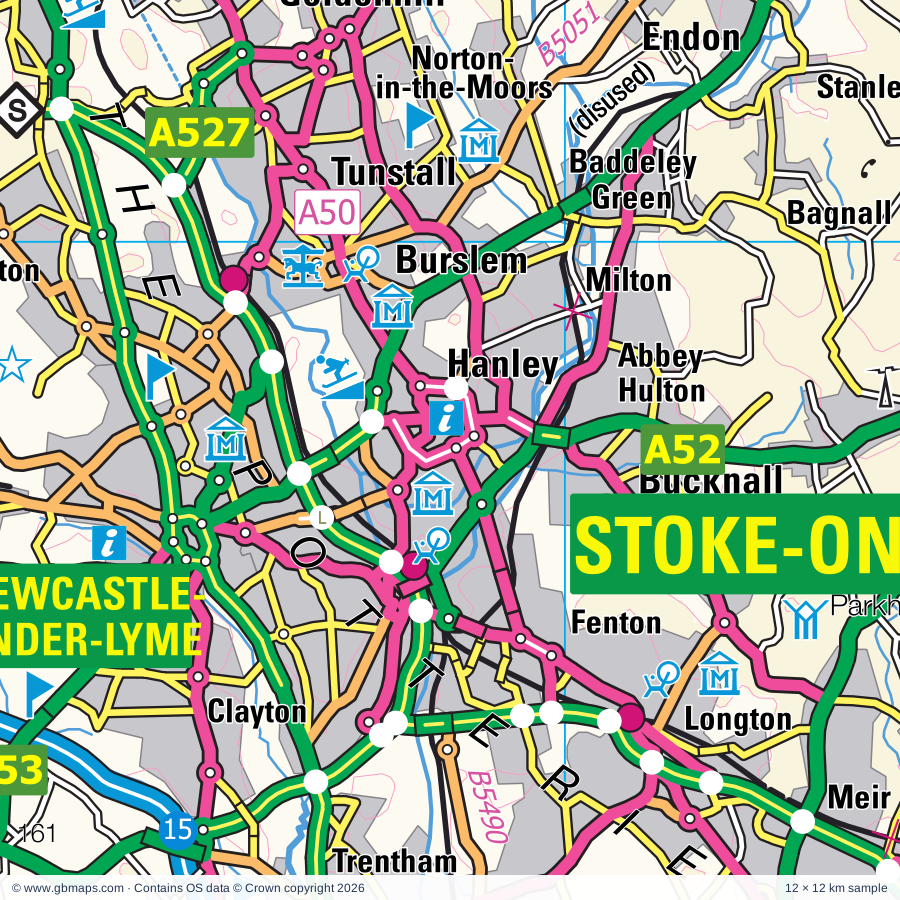
Stoke-on-Trent regional road map. Full 60 × 60 km PDF, SVG and Illustrator files, with a free PDF sample.

GBMAPS.COM

Stoke-on-Trent Regional Road Map

Call Us Now for Help01751 473136

GREAT BRITAIN ROAD ATLAS · 1:250,000 GB-390-0360

Stoke-on-Trent & surrounding area

Explore the full 60 × 60 km Stoke-on-Trent regional road map at 1:250,000, covering Biddulph, Congleton, Kidsgrove, Leek, Bollington. Compare the complete coverage below; a detailed PDF sample is available free.

STOKE-ON-TRENT & SURROUNDING AREAREGIONAL ROAD MAP
60 × 60 km · Full map previewDownload the free SVG ↓

INSIDE THE FULL 60 × 60 KM MAP

Explore the Stoke-on-Trent map area

1:250,000 cartography

Towns, villages & places

More mapped places (306)
  • Gatley
  • Marple
  • Hale
  • Altrincham
  • Ashbourne
  • Uttoxeter
  • Lymm
  • Warrington
  • Newtown
  • Timbersbrook
  • Key Green
  • Rudyard
  • Horton
  • Astbury
  • Heaton
  • Harriseahead
  • Bosley
  • Eaton
  • Newchapel
  • Longsdon
  • Endon
  • Brownlow
  • Rodeheath
  • Danebridge
  • Stanley
  • Wincle
  • Highlane
  • Meerbrook
  • Bagnall
  • Marton
  • Oakgrove
  • Talke
  • Allgreave
  • Cheddleton
  • Gawsworth
  • Blackshaw Moor
  • Arclid
  • Swettenham
  • Gleadsmoss
  • Thorncliffe
  • Wildboarclough
  • Bradnop
  • Langley
  • Wetley Rocks
  • Siddington
  • Lower Withington
  • Werrington
  • Hassall
  • Audley
  • Henbury
  • Consall
  • Flash
  • Bradwall
  • Mixon
  • Wheelock
  • Winterley
  • Barthomley
  • Goostrey
  • Ipstones
  • Onecote
  • Brookhouse
  • Elworth
  • Rainow
  • Balterley
  • Leycett
  • Prestbury
  • Haslington
  • Kingsley
  • Cookshill
  • Cranage
  • Chelford
  • Keele
  • Ford
  • Foxt
  • Froghall
  • Hollinsclough
  • Butterton
  • Dilhorne
  • Fawfieldhead
  • Over Peover
  • Winkhill
  • Betley
  • Weston
  • Marthall
  • Warslow
  • Whiston
  • Warmingham
  • Allostock
  • Hanchurch
  • Grindon
  • Longnor
  • Wrinehill
  • Chorlton
  • Forsbrook
  • Waterfall
  • Brund
  • Waterhouses
  • Byley
  • Adlington
  • Blakenhall
  • Crowdicote
  • Ollerton
  • Hough
  • Cauldon
  • Sheen
  • Whitmore
  • Swan Green
  • Wetton
  • Knowl Wall
  • Wimboldsley
  • Shavington
  • Barlaston
  • Oakamoor
  • Checkley
  • Tittensor
  • Kettleshulme
  • Fernilee
  • Cotton
  • Cresswell
  • Pilsbury
  • Beech
  • Onneley
  • Taxal
  • Wybunbury
  • Fulford
  • Woodford
  • Mobberley
  • Hartington
  • Calton
  • King Sterndale
  • Hopedale
  • Plumley
  • Chelmorton
  • Walgherton
  • Combs
  • Alstonefield
  • Moddershall
  • Willaston
  • Farley
  • Ramshorn
  • Handforth
  • Aston
  • Woore
  • Oulton
  • Lower Tean
  • Maer
  • Milldale
  • Worleston
  • Heathcote
  • Flagg
  • Stapeley
  • Swynnerton
  • Alton
  • Blackbrook
  • Hatherton
  • Styal
  • Great Gate
  • Ilam
  • Cotwalton
  • Cranberry
  • Wootton
  • Dorrington
  • Biggin
  • Checkley
  • Blackwell
  • Disley
  • Monyash
  • Cotes
  • Blore
  • Hollington
  • Swinscoe
  • Knighton
  • Croxden
  • Moulton
  • Standon
  • Wormhill
  • Davenham
  • Taddington
  • Chinley
  • Stanton
  • Mere
  • Wincham
  • Hankelow
  • Podmore
  • Fole
  • Buerton
  • Kingsmead
  • Ashley
  • Ashley
  • Ellastone
  • Marston
  • Pickmere
  • Thorpe
  • Wettenhall
  • Chatcull
  • Denstone
  • Yarnfield
  • Acton
  • Mill Meece
  • Withington
  • Slackhall
  • Sparrowpit
  • Salterswall
  • Rostherne
  • Wheston
  • Norbury
  • Beamhurst
  • Sheldon
  • Milwich
  • Mucklestone
  • Barbridge
  • Tissington
  • Hartford
  • Slindon
  • Whitegate
  • Burland
  • Loggerheads
  • Audlem
  • Coton
  • Wardle
  • Mapleton
  • Kinsey Heath
  • Peak Forest
  • Pikehall
  • Rocester
  • Field
  • Mayfield
  • Mellor
  • Ravensmoor
  • Wetwood
  • Tideswell
  • Middleton
  • Croxton
  • Burston
  • Roston
  • Cressbrook
  • Stramshall
  • Fairoak
  • Sturbridge
  • Hayfield
  • Snelston
  • Litton
  • Bowdon
  • Sound
  • Coxbank
  • Barnton
  • Clifton
  • Monsal Head
  • Sugnall
  • Fradswell
  • Comberbach
  • Betton
  • Arley
  • Bramshall
  • Ashford in the Water
  • Adderley
  • Gratwich
  • Sandiway
  • Aston
  • Wardlow
  • Weaverham
  • Hales
  • Waldley
  • Little Hucklow
  • Almington
  • Antrobus
  • Outlands
  • Little Leigh
  • Newhall
  • Coplow Dale
  • Broomedge
  • Wilkesley
  • Grindlow
  • Burleydam
  • Foolow
  • Chipnall
  • Edale
  • Wyaston
  • Doveridge
  • Castleton
  • Osmaston
  • Little Cubley
  • Bradwell
  • Heatley
  • Longslow
  • Yeaveley
  • Woodseaves
  • Warburton
  • Abney
  • Alkmonton
  • Hope
  • Brough
  • Stretton
  • Longford
  • Sutton
  • Boylestone
  • Aston
  • Calverhall
  • Marchington
  • Bletchley
  • Thornhill
  • Ternhill
  • Sudbury
  • Foston
  • Wollerton
  • Scropton

Roads across this sheet

M6, M56, M60, A6, A34, A41, A49, A50, A51, A52, A53, A54, A56, A57, A500, A515, A517, A518, A519, A520, A521, A522, A523, A524

More road numbers

A525, A527, A529, A530, A531, A532, A533, A534, A535, A536, A537, A538, A555, A556, A559, A560, A574, A623, A624, A626, A627, A5004, A5005, A5006, A5007, A5008, A5009, A5010, A5011, A5012, A5015, A5018, A5019, A5020, A5022, A5033, A5034, A5035, A5060, A5061, A5078, A5102, A5143, A5144, A5149, A5182, A5270, A5271, A5272, A5509, A6015, A6020, A6144, A6187, B5013, B5017, B5026, B5027, B5029, B5030, B5031, B5032, B5033, B5034, B5038, B5039, B5041, B5044, B5045, B5047, B5050, B5051, B5053, B5054, B5055, B5056, B5059, B5066, B5071, B5074, B5075, B5076, B5077, B5078, B5079, B5081, B5082, B5083, B5085, B5086, B5087, B5088, B5090, B5091, B5094, B5095, B5142, B5144, B5153, B5156, B5157, B5158, B5159, B5160, B5161, B5162, B5163, B5164, B5165, B5166, B5167, B5168, B5210, B5308, B5309, B5315, B5331, B5334, B5338, B5341, B5352, B5355, B5356, B5357, B5358, B5359, B5367, B5368, B5369, B5370, B5371, B5374, B5391, B5392, B5415, B5417, B5465, B5470, B5490, B5500, B6049, B6062, B6101, B6102, B6171, B6465

Rivers & waterways

Bridgewater Canal, Caldon Canal, Head of Trent, Llangollen Canal, Macclesfield Canal, Manchester Ship Canal, Peak Forest Canal, River Alport, River Ashop, River Blithe, River Bollin, River Churnet

More waterways

River Dane, River Dean, River Derwent, River Dove, River Goyt, River Manifold, River Mersey, River Noe, River Tern, River Trent, River Weaver, River Wheelock, River Wye, Shropshire Union Canal, Shropshire Union Canal (Middlewich Branch), Trent & Mersey Canal, Trent and Mersey Canal, Weaver Navigation, Wincham Brook

Landmarks & landscape

Adlington Hall, Alderley Edge, Alton Towers Theme Park, Anderton Boat Lift, Anson Museum, Apedale Community Country Park, Apedale Heritage Centre, Applejacks Farm, Arbor Low, Arbor Low (Henge), Arley Hall, Arley Hall and Gardens, PEAK DISTRICT NATIONAL PARK

More named features

Astbury Mere Country Park, Baguley Hall, Biddulph Grange Country Park, Biddulph Grange Garden, Blackbrook Zoological Park, Blaze Farm, Bramhall Hall, Brereton Heath Park, Bridgemere Garden World, Brookside Miniature Railway, Buxton Country Park, Buxton Go Ape, Buxton Museum and Art Gallery, Buxton Raceway, Candle Workshop, Capesthorne Hall, Cat and Fiddle, Ceramica The Pottery Showcase, Chatterley Whitfield Heritage Country Park, Chestnut Centre Conservation Park, Childrens Zoo, Churnet Valley Railway, Consall Gardens, Consall Nature Park, Coombes Valley Nature Reserve, Craft Centre, Croxden Abbey, Cuckoo Clock Museum, Dagfields Craft & Antiques Centre, Darley Moor Sports Centre, Deep Hayes Country Park, Deep Hayes Country Park Visitor Centre, Dorfold Hall, Dorfold Hall Gardens, Dunge Valley Gardens, Dunham Massey, Dunham Massey Hall, Dunham Massey Hall Garden, Englesea-brook Heritage Centre, Etruria Industrial Museum, The Potteries Museum, The Dudson Centre, Farmcraft Rare Breeds Centre, Flint Mill Museum, Ford Green Hall Museum, Foxfield Steam Railway, Freshfields Donkey Sanctuary, Gauntlet Birds of Prey Centre, Gawsworth Hall, Gladstone Pottery Museum, Greenway Bank Country Park & Visitor Centre, Hack Green Secret Nuclear Bunker, Hare Hill Garden, Hawksmoor Nature Reserve, Hayfield Countryside Centre, Heart of England Equestrian, Hillside Bird Oasis, Home Farm, Ilam Country Park, Ilam Park Visitor Centre, John Beswick Studio, Leeds Pottery, Aynsley China, Knutsford Heritage Centre, Ladderedge Country Park, Lakemoor Park Farm, Lathkill Dale National Nature Reserve, Little Moreton Hall, Longnor Craft Centre, Lud's Church (chasm) Beauty Spot, Lyme Hall, Lyme Park, Manifold Valley Visitor Centre, Marbury Park Country Park, Mill Meece Pumping Station, Millers Dale and Priestcliffe Lees, Monks Dale, Moorcroft, Moorland Pottery, Moorland Visitor Centre, Museum of Childhood, Nantwich Museum, Nether Alderley Mill, Northwich Salt Museum, The Dock Road Edwardian Pumping Station, Old Colehurst Manor, Old Hall, Old Man of Mow, Parkhall Country Park, Pavilion Gardens, Peover Hall, Peveril Castle, Quarry Bank Mill, Reaseheath College, Rode Hall, Rode Hall Garden, Rudyard Lake Visitor Centre, Rudyard Lake Railway, Sandbach Crosses, Shavington Park, Shelton Pottery, Silverdale Country Park, Snugbury's Famous Jersey Ice Cream, Solar Farm, Stockley Farm, Sudbury Hall, Tabley House, Tatton Hall, Tatton Home Farm, Tatton Park, Teggs Nose Country Park, The Borough Museum and Art Gallery, The Brindley Mill, The Dorothy Clive Memorial Garden, The Old Manor, The Quinta Aboretum, The Railway Age, The Roaches, The Threshing Barn, The Trentham Estate, The Wedgewood Story, Tideswell Dale, Tissington Hall, Tittesworth Reservoir Visitor Centre, Trentham Monkey Forest, Tumuli, Uttoxeter Heritage Centre, Uttoxeter Racecourse, Visitor Centre, Visitor Centre, Granada Arboretum, Walton Hall, Walton Hall Gardens, Warrington Museum & Art Gallery, Wedgewood Museum, West Park Museum, Paradise Mill, Silk Heritage Centre, Whitmore Hall, Wythenshaw Community Farm, Wythenshawe Hall

Local authority & parish coverage

Wholly or partly within the full map rectangle. These boundaries are coverage information, not additional artwork layers.

  • Cheshire EastPartly within
  • Cheshire West and ChesterPartly within
  • City of Stoke-on-TrentWholly within
  • Derbyshire Dales DistrictPartly within
  • East Staffordshire DistrictPartly within
  • HaltonPartly within
  • High Peak DistrictPartly within
  • Manchester DistrictPartly within
  • Newcastle-under-Lyme DistrictWholly within
  • Sheffield DistrictPartly within
  • ShropshirePartly within
  • South Derbyshire DistrictPartly within
  • Stafford DistrictPartly within
  • Staffordshire Moorlands DistrictWholly within
  • Stockport DistrictPartly within
  • Trafford DistrictPartly within
  • WarringtonPartly within
Wards & electoral divisions 247 areas
  • Abbey Hulton Ward
  • Alderley Edge Ward
  • Alsager Ward
  • Alton Ward
  • Altrincham Ward
  • Appleton Ward (part)
  • Ashbourne North Ward (part)
  • Ashbourne South Ward (part)
  • Audlem Ward (part)
  • Audley Ward
  • Baddeley, Milton & Norton Ward
  • Bagnall and Stanley Ward
  • Baguley Ward
  • Bakewell Ward (part)
  • Barlaston Ward
  • Barms Ward
  • Basford & Hartshill Ward
  • Bentilee, Ubberley & Townsend Ward
  • Bewsey & Whitecross Ward (part)
  • Biddulph East Ward
  • Biddulph Moor Ward
  • Biddulph North Ward
  • Biddulph South Ward
  • Biddulph West Ward
  • Birches Head & Northwood Ward
  • Blackbrook Ward
  • Blurton Ward
  • Blythe Ward (part)
  • Bollington Ward
  • Bonsall & Winster Ward (part)
  • Boothen Ward
  • Bowdon Ward (part)
  • Bradeley & Chell Heath Ward
  • Bradwell Ward
  • Bradwell Ward (part)
  • Brailsford Ward (part)
  • Bramhall North Ward
  • Bramhall South & Woodford Ward
  • Bredbury Green & Romiley Ward (part)
  • Brereton Rural Ward
  • Brinnington & Stockport Central Ward (part)
  • Broadheath Ward (part)
  • Broken Cross and Upton Ward
  • Brooklands Ward (part)
  • Brown Edge and Endon Ward
  • Bucknall & Eaton Park Ward
  • Bunbury Ward (part)
  • Burbage Ward
  • Burslem Park Ward
  • Burslem Ward
  • Buxton Central Ward
  • Calver & Longstone Ward (part)
  • Caverswall Ward
  • Cellarhead Ward
  • Chapel East Ward
  • Chapel West Ward
  • Cheadle East & Cheadle Hulme North Ward (part)
  • Cheadle Hulme South Ward
  • Cheadle North East Ward
  • Cheadle South East Ward
  • Cheadle West & Gatley Ward
  • Cheadle West Ward
  • Checkley Ward
  • Cheddleton Ward
  • Chelford Ward
  • Churnet Ward
  • Clayton Ward
  • Congleton East Ward
  • Congleton West Ward
  • Corbar Ward
  • Cote Heath Ward
  • Crackley & Red Street Ward
  • Crewe Central Ward
  • Crewe East Ward
  • Crewe North Ward
  • Crewe South Ward
  • Crewe St. Barnabas Ward
  • Crewe West Ward
  • Cross Heath Ward
  • Crown Ward (part)
  • Dane Valley Ward
  • Dane Ward
  • Daresbury, Moore & Sandymoor Ward (part)
  • Davenham, Moulton & Kingsmead Ward
  • Davenport & Cale Green Ward
  • Didsbury East Ward (part)
  • Disley Ward
  • Dovedale, Parwich & Brassington Ward (part)
  • Doveridge & Sudbury Ward
  • Dresden & Florence Ward
  • Eccleshall Ward (part)
  • Edgeley Ward (part)
  • Etruria & Hanley Ward
  • Fairfield & Howley Ward
  • Fenton East Ward
  • Fenton West & Mount Pleasant Ward
  • Ford Green & Smallthorne Ward
  • Forsbrook Ward
  • Fulford Ward
  • Gawsworth Ward
  • Goldenhill & Sandyford Ward
  • Grappenhall Ward
  • Great Chell & Packmoor Ward
  • Hale Barns & Timperley South Ward
  • Hale Ward
  • Hamps Valley Ward
  • Handforth Ward
  • Hanford, Newstead & Trentham Ward
  • Hanley Park, Joiner's Square & Shelton Ward
  • Hartford & Greenbank Ward
  • Hartington & Taddington Ward
  • Hartshill Park & Stoke Ward
  • Haslington Ward
  • Hathersage Ward (part)
  • Hayfield Ward (part)
  • Hazel Grove Ward
  • Heald Green Ward
  • Heath Ward
  • Heatons South Ward (part)
  • High Legh Ward
  • Hilton Ward (part)
  • Holditch & Chesterton Ward
  • Hollybush Ward
  • Hope Valley Ward (part)
  • Horton Ward
  • Ipstones Ward
  • Keele Ward
  • Kidsgrove & Ravenscliffe Ward
  • Knutsford Ward
  • Knutton Ward
  • Latchford East Ward
  • Latchford West Ward
  • Leek East Ward
  • Leek North Ward
  • Leek South Ward
  • Leek West Ward
  • Leighton Ward
  • Lightwood North & Normacot Ward
  • Limestone Peak Ward
  • Little Chell & Stanfield Ward
  • Loggerheads Ward
  • Longton & Meir Hay South Ward
  • Lymm North & Thelwall Ward
  • Lymm South Ward
  • Macclesfield Central Ward
  • Macclesfield East Ward
  • Macclesfield Hurdsfield Ward
  • Macclesfield South Ward
  • Macclesfield Tytherington Ward
  • Macclesfield West and Ivy Ward
  • Madeley & Betley Ward
  • Maer & Whitmore Ward
  • Manifold Ward
  • Manor Ward (part)
  • Marbury Ward (part)
  • Marple North Ward (part)
  • Marple South & High Lane Ward
  • May Bank Ward
  • Meir Hay North, Parkhall & Weston Coyney Ward
  • Meir North Ward
  • Meir Park Ward
  • Meir South Ward
  • Middlewich Ward
  • Milwich Ward (part)
  • Mobberley Ward
  • Moorcroft & Sneyd Green Ward
  • Nantwich North and West Ward
  • Nantwich South and Stapeley Ward
  • New Mills East Ward
  • New Mills West Ward
  • Newchapel & Mow Cop Ward
  • Norbury & Woodsmoor Ward
  • Norbury Ward (part)
  • Northenden Ward (part)
  • Northwich Leftwich Ward
  • Northwich Winnington & Castle Ward
  • Northwich Witton Ward
  • Odd Rode Ward
  • Offerton Ward
  • Orford Ward (part)
  • Penkhull & Springfields Ward
  • Poplars & Hulme Ward (part)
  • Poulton North Ward (part)
  • Poulton South Ward (part)
  • Poynton East and Pott Shrigley Ward
  • Poynton West and Adlington Ward
  • Prestbury Ward
  • Rixton & Woolston Ward (part)
  • Rudheath Ward
  • Sandbach Elworth Ward
  • Sandbach Ettiley Heath and Wheelock Ward
  • Sandbach Heath and East Ward
  • Sandbach Town Ward
  • Sandford Hill Ward
  • Seighford & Church Eaton Ward (part)
  • Sett Ward (part)
  • Shakerley Ward
  • Sharston Ward
  • Shavington Ward
  • Silverdale Ward
  • St. Michael's & Stonefield Ward
  • Stannington Ward (part)
  • Stockton Heath Ward
  • Stone Bench Ward
  • Stramshall & Weaver Ward
  • Sutton Ward
  • Swynnerton & Oulton Ward
  • Talke & Butt Lane Ward
  • Tarporley Ward (part)
  • Temple Ward
  • Thistleberry Ward
  • Tideswell Ward
  • Timperley Central Ward
  • Timperley North Ward (part)
  • Town Ward
  • Town Ward
  • Trent Vale & Oak Hill Ward
  • Tunstall Ward
  • Walton Ward
  • Weaver & Cuddington Ward (part)
  • Werrington Ward
  • Westbury Park & Northwood Ward
  • Westlands Ward
  • Whaley Bridge Ward
  • Willaston and Rope Ward
  • Wilmslow Dean Row Ward
  • Wilmslow East Ward
  • Wilmslow Lacey Green Ward
  • Wilmslow West and Chorley Ward
  • Winsford Dene Ward
  • Winsford Gravel Ward
  • Winsford Over & Verdin Ward (part)
  • Winsford Swanlow Ward
  • Winsford Wharton Ward
  • Wistaston Ward
  • Wolstanton Ward
  • Woodhouse Park Ward
  • Wrenbury Ward (part)
  • Wybunbury Ward
  • Youlgrave Ward (part)
  • Cheswardine ED (part)
  • Hodnet ED (part)
  • Market Drayton East & Rural ED
  • Market Drayton North ED
  • Market Drayton South ED
  • Prees ED (part)
  • Whitchurch South ED (part)
Civil parishes & communities 347 areas
  • Abney and Abney Grange CP (part)
  • Acton Bridge CP (part)
  • Adbaston CP (part)
  • Adderley CP
  • Adlington CP
  • Alderley Edge CP
  • Alkmonton CP (part)
  • Allostock CP
  • Alpraham and Calveley CP (part)
  • Alsager CP
  • Alstonefield CP
  • Alton CP
  • Anderton with Marbury CP
  • Antrobus CP
  • Appleton CP (part)
  • Arclid CP
  • Ashbourne CP
  • Ashford in the Water CP (part)
  • Ashley CP
  • Aston By Budworth CP
  • Aston CP
  • Aston Juxta Mondrum CP
  • Audlem CP
  • Audley Rural CP
  • Austerson CP
  • Baddiley CP (part)
  • Baddington CP
  • Bagnall CP
  • Bakewell CP (part)
  • Ballidon CP (part)
  • Balterley CP
  • Bamford CP (part)
  • Barlaston CP
  • Barnton CP
  • Barthomley CP
  • Barton Blount CP (part)
  • Betchton CP
  • Betley CP
  • Bexton CP
  • Biddulph CP
  • Blackwell in the Peak CP
  • Blore with Swinscoe CP
  • Bollington CP
  • Bosley CP
  • Bostock CP
  • Boylestone CP
  • Bradbourne CP (part)
  • Bradfield CP (part)
  • Bradley CP (part)
  • Bradnop CP
  • Bradwall CP
  • Bradwell CP
  • Brassington CP (part)
  • Brereton CP
  • Brindley CP (part)
  • Broomhall CP
  • Brough and Shatton CP (part)
  • Brown Edge CP
  • Brushfield CP
  • Buerton CP
  • Burland and Acton CP (part)
  • Butterton CP
  • Byley CP
  • Castleton CP
  • Caverswall CP
  • Chapel and Hill Chorlton CP
  • Chapel-en-le-Frith CP
  • Cheadle CP
  • Chebsey CP (part)
  • Checkley CP
  • Cheddleton CP
  • Chelford CP
  • Chelmorton CP
  • Cheswardine CP (part)
  • Chinley, Buxworth and Brownside CP
  • Cholmondeston CP
  • Chorley CP
  • Church Broughton CP (part)
  • Church Lawton CP
  • Church Minshull CP
  • Clifton and Compton CP
  • Comberbach CP
  • Congleton CP
  • Consall CP
  • Coole Pilate CP
  • Cotton CP
  • Cranage CP
  • Crewe CP
  • Croxden CP
  • Cubley CP
  • Cuddington CP (part)
  • Daresbury CP (part)
  • Darnhall CP
  • Davenham CP
  • Denstone CP
  • Derwent CP (part)
  • Dilhorne CP
  • Disley CP
  • Dodcott cum Wilkesley CP (part)
  • Doddington and District CP
  • Doveridge CP
  • Draycott in the Clay CP (part)
  • Draycott in the Moors CP
  • Dunham Massey CP (part)
  • Dutton CP (part)
  • Eaton CP
  • Eaton and Alsop CP
  • Eccleshall CP (part)
  • Edale CP
  • Edlaston and Wyaston CP (part)
  • Ellastone CP
  • Endon and Stanley CP
  • Eyam CP (part)
  • Farley CP
  • Fawfieldhead CP
  • Fenny Bentley CP
  • Flagg CP
  • Foolow CP (part)
  • Forsbrook CP
  • Foston and Scropton CP (part)
  • Fradswell CP (part)
  • Fulford CP
  • Gawsworth CP
  • Gayton CP (part)
  • Goostrey CP
  • Grappenhall and Thelwall CP
  • Gratton CP (part)
  • Great Budworth CP
  • Great Hucklow CP
  • Great Longstone CP (part)
  • Great Warford CP
  • Green Fairfield CP
  • Grindlow CP
  • Grindon CP
  • Hanbury CP (part)
  • Handforth CP
  • Hankelow CP
  • Hartford CP
  • Hartington Middle Quarter CP
  • Hartington Nether Quarter CP
  • Hartington Town Quarter CP
  • Hartington Upper Quarter CP
  • Haslington CP
  • Hassall CP
  • Hatherton CP
  • Hatton CP (part)
  • Haughton CP (part)
  • Hayfield CP (part)
  • Hazlebadge CP
  • Heathylee CP
  • Heaton CP
  • Henbury CP
  • High Legh CP
  • Higher Hurdsfield CP
  • Hilderstone CP
  • Hodnet CP (part)
  • Hollinsclough CP
  • Holmes Chapel CP
  • Hope CP
  • Hope Woodlands CP (part)
  • Horton CP
  • Hough and Chorlton CP
  • Hulme Walfield CP
  • Hungry Bentley CP
  • Ightfield CP (part)
  • Ilam CP
  • Ipstones CP
  • Keele CP
  • Kettleshulme and Lyme Handley CP
  • Kidsgrove CP
  • King Sterndale CP
  • Kingsley CP
  • Kingsmead CP
  • Kingstone CP (part)
  • Kniveton CP (part)
  • Knutsford CP
  • Lach Dennis and Lostock Green CP
  • Leek CP
  • Leekfrith CP
  • Leigh CP
  • Leighton CP
  • Little Bollington with Agden CP
  • Little Budworth CP (part)
  • Little Hucklow CP
  • Little Leigh CP (part)
  • Little Longstone CP
  • Little Warford CP
  • Litton CP
  • Loggerheads CP
  • Longford CP (part)
  • Longnor CP
  • Longsdon CP
  • Lostock Gralam CP
  • Lower Withington CP
  • Lymm CP
  • Macclesfield CP
  • Macclesfield Forest and Wildboarclough CP
  • Madeley CP
  • Maer CP
  • Mapleton CP
  • Marchington CP (part)
  • Market Drayton CP
  • Marston CP (part)
  • Marston CP
  • Marston Montgomery CP
  • Marthall CP
  • Marton CP
  • Mayfield CP
  • Mere CP
  • Middleton and Smerrill CP (part)
  • Middlewich CP
  • Millington and Rostherne CP
  • Milwich CP
  • Minshull Vernon CP
  • Mobberley CP
  • Monyash CP
  • Moreton Say CP
  • Moreton cum Alcumlow CP
  • Moston CP
  • Mottram St. Andrew CP
  • Moulton CP
  • Nantwich CP
  • Nether Alderley CP
  • Nether Peover CP
  • New Mills CP (part)
  • Newbold Astbury CP
  • Newhall CP (part)
  • Newton Grange CP
  • Norbury and Roston CP
  • North Rode CP
  • Northwich CP
  • Norton in Hales CP
  • Oakamoor CP
  • Odd Rode CP
  • Offcote and Underwood CP (part)
  • Okeover CP
  • Ollerton CP
  • Onecote CP
  • Osmaston CP (part)
  • Over Alderley CP
  • Over Haddon CP (part)
  • Parwich CP
  • Peak Forest CP
  • Peover Inferior CP
  • Peover Superior and Snelson CP
  • Pickmere CP
  • Plumley CP
  • Poole CP
  • Pott Shrigley CP
  • Poulton-with-Fearnhead CP (part)
  • Poynton with Worth CP
  • Prees CP (part)
  • Prestbury CP
  • Quarnford CP
  • Rainow CP
  • Ramshorn CP
  • Ringway CP
  • Rixton-with-Glazebrook CP (part)
  • Rocester CP
  • Rodsley CP (part)
  • Rope CP
  • Rudheath CP
  • Rushton CP
  • Rushton CP (part)
  • Sandbach CP
  • Sandon and Burston CP (part)
  • Shavington cum Gresty CP
  • Sheen CP
  • Sheldon CP
  • Shirley CP (part)
  • Siddington CP
  • Silverdale CP
  • Smallwood CP
  • Snelston CP
  • Somerford Booths CP
  • Somerford CP
  • Somersal Herbert CP
  • Sound CP
  • Sproston CP
  • Standon CP
  • Stanthorne and Wimboldsley CP
  • Stanton CP
  • Stapeley and District CP
  • Stockton Heath CP
  • Stoke and Hurleston CP
  • Stoke upon Tern CP (part)
  • Stone CP
  • Stone Rural CP (part)
  • Stoney Middleton CP (part)
  • Stowe-by-Chartley CP (part)
  • Stretton CP
  • Styal CP
  • Sudbury CP
  • Sutton CP
  • Sutton upon Tern CP (part)
  • Swettenham CP
  • Swynnerton CP
  • Tabley Inferior CP
  • Tabley Superior CP
  • Taddington CP
  • Thornhill CP (part)
  • Thorpe CP
  • Tideswell CP
  • Tissington and Lea Hall CP (part)
  • Tittesworth CP
  • Toft CP
  • Twemlow CP
  • Uttoxeter CP
  • Uttoxeter Rural CP (part)
  • Walgherton CP
  • Walton CP (part)
  • Warburton CP (part)
  • Wardle CP (part)
  • Wardlow CP
  • Warmingham CP
  • Warslow and Elkstones CP
  • Waterhouses CP
  • Weaverham CP (part)
  • Werrington CP
  • Weston and Crewe Green CP
  • Wettenhall CP
  • Wetton CP
  • Whaley Bridge CP
  • Wheston CP
  • Whitchurch Rural CP (part)
  • Whitegate and Marton CP (part)
  • Whitgreave CP (part)
  • Whitley CP (part)
  • Whitmore CP
  • Willaston CP
  • Wilmslow CP
  • Wincham CP
  • Wincle CP
  • Winsford CP
  • Wistaston CP
  • Woolstanwood CP
  • Woolston CP (part)
  • Woore CP
  • Wootton CP
  • Worleston CP
  • Wormhill CP
  • Wrenbury cum Frith CP (part)
  • Wybunbury CP
  • Yarnfield and Cold Meece CP
  • Yeaveley CP
  • Yeldersley CP (part)
  • Youlgreave CP (part)

Source: the GBMaps road atlas, OS Boundary-Line and postcode mapping datasets. Source editions are being checked for publication. Unmarked boundary names are wholly within the sheet; “part” means the map edge crosses the area.

Place lists are selected from the map source, not a complete gazetteer. Named features describe the cartography; visitor facilities and opening status are not verified. The free sample covers only 12 × 12 km of this larger sheet.

INSIDE YOUR DOWNLOAD

A proper road map, in useful formats

Road classifications, towns and villages, railways, rivers, landscape detail and tourist symbols, brought together in the GBMaps regional road atlas style.

PDF filePDFSVG fileSVGAdobe Illustrator AI fileAi

PDF for the finished map. SVG and layered Illustrator artwork for adapting colours, adding your own information and preparing designs.

THE FINISHED SHEET

Designed for print and presentation

Map coverage
60 × 60 km
Sample coverage
12 × 12 km
Print layout
A3 landscape · enlarged 1:250k cartography
Sheet furniture
Border, scale bar, key & north arrow

A few useful details

What changes when I select another square?

Select a surrounding square to bring it into the centre and reveal the maps around it. Each square is a different 60 × 60 km map. The preview, free sample and selected download change together. Neighbouring sheets overlap by 30 km so you can choose the coverage that suits you.

Is the free sample a vector map?

The on-page detail is an SVG. The free download is a separate 12 × 12 km PDF with a link to the full map. Please retain its copyright credits and product link when sharing it.

Can I buy a larger combined map?

These downloads are individual ready-made sheets. Contact GBMaps if you need a larger combined area.

FREE PDF SAMPLE

Your free map sample

Your free 12 × 12 km sample includes a link back to this map, so you can return for the full area whenever you need it.

Download free PDF sample ↓

Get your Stoke-on-Trent map

Map download bundle

£24.00including VATOne payment

Pay securely

One payment. Your map stays open.

Your map download

Your map files

Preparing your download…

Checking your private download link…

Your map downloads

Already bought a map?

Find the downloads from your purchases.

Enter the email address you used at checkout. We’ll email you a private link to your available map downloads.