Southampton regional road map. Full 60 × 60 km PDF, SVG and Illustrator files, with a free PDF sample.

GBMAPS.COM

Southampton Regional Road Map

Call Us Now for Help01751 473136

GREAT BRITAIN ROAD ATLAS · 1:250,000 GB-420-0090

Southampton & surrounding area

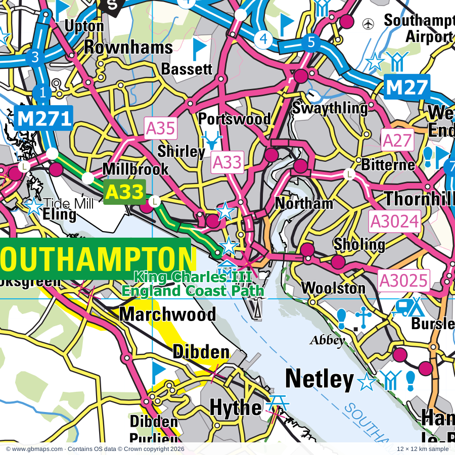
Explore the full 60 × 60 km Southampton regional road map at 1:250,000, covering Southampton, Christchurch, New Milton, Bournemouth, Lymington. Compare the complete coverage below; a detailed PDF sample is available free.

SOUTHAMPTON & SURROUNDING AREAREGIONAL ROAD MAP
60 × 60 km · Full map previewDownload the free SVG ↓

INSIDE THE FULL 60 × 60 KM MAP

Explore the Southampton map area

1:250,000 cartography

Towns, villages & places

More mapped places (180)

Roads across this sheet

M3, M27, M271, A27, A31, A33, A35, A36, A326, A334, A335, A336, A337, A338, A341, A347, A348, A349, A350, A351, A352, A354, A3020, A3024

More road numbers

A3025, A3035, A3040, A3049, A3054, A3055, A3057, A3060, A3090, B3033, B3035, B3036, B3037, B3038, B3039, B3043, B3053, B3054, B3055, B3056, B3058, B3059, B3061, B3063, B3064, B3065, B3066, B3067, B3068, B3069, B3070, B3072, B3073, B3074, B3075, B3076, B3078, B3079, B3080, B3081, B3082, B3093, B3320, B3322, B3323, B3325, B3341, B3342, B3347, B3351, B3354, B3369, B3397, B3399, B3401

Rivers & waterways

Beaulieu River, Corfe River, Lymington River, Moors River, River Allen, River Avon, River Frome, River Itchen, River Piddle or Trent, River Stour, River Test, The Itchen Navigation

Landmarks & landscape

Adventure Wonderland, Alderholt Mill, Apple Court Gardens, Artsway, Avon Heath Country Park, Badbury Rings, Beaulieu Abbey, Beaulieu Hotel, Blackgang Chine Theme Park, Blackgang Sawmill & St Catherine's Quay, Blackwater Arboretum, Blue Pool, NEW FOREST NATIONAL PARK

More named features

Bolderwood Arboretum Ornamental Drive, Bolderwood Deer Sanctuary, Bournemouth Aviation Museum, Breamore Countryside Museum, Breamore House, Brighstone Village Museum, Brownsea Island, Bucklers Hard Maritime Museum, Bursledon Brickworks, Calshot Castle, Carisbrooke Castle, Castle View Visitor Centre, Model Village, Chawton Solar Farm, Chessell Pottery, Chettle House, Christchurch Castle Keep and Motte, Christchurch Priory, Cliff Lift, Artificial Surf Reef, Bournemouth Inrenational Centre, Coastal Activity Park, Coleman's Farm Park, Compton Acres Gardens, Constables House, Corfe Castle, Corfe Castle Museum, Swanage Railway Museum, Cowes Maritime Museum, Sir Max Aitken Museum, Cranborne Common Nature Reserve, Cranborne Manor Gardens, Creech Barrow Seven Memorial, Cuckoo Hill Railway, Deans Court Gardens, Delta Force, Dimbola Lodge Photographic Museum, Dinosaur Farm Museum, Dorset Heavy Horse and Animal Centre, Durlston Country Park, Durrants Solar Farm, Durslston Country Park Visitor Centre, Eastleigh Town Museum, Edmonsham House & Gardens, Eling Tide Mill, Totton and Eling Heritage Centre, Exbury Gardens, Exbury Gardens Steam Railway, Farmer Palmer's Animal World, Fordingbridge Museum, Fort Victoria Country Park, Fort Victoria Marine Aquarium, Furzey Gardens, Go Ape Itchen Valley, Golden Hill Fort Country Park, Hall of Aviation, Tudor House, SeaCity, Hamptworth Lodge, Hengistbury Head Nature Reserve, Hengistbury Head Visitor Centre, Highcliffe Castle, Highcliffe Castle Visitor Centre, Holly Hill Woodland Park, Homeland Solar Farm, Honeybrook Farm and Country Park, Hurst Castle, Itchen Valley Country Park, Jurassic Coast (World Heritage Site), Kingston Lacy, Knightwood Oak, Knoll Beach Visitor Centre, Knoll Gardens, Knowlton Church and Earthworks, Lakeside Country Park, Larmer Tree Gardens, Lepe Country Park, Liberty's Owl Raptor & Reptile Centre, Longdown Activity Farm, Lymington-Keyhaven Nature Reserve, MGFT Animal Sanctuary, Maize Maze, Matchams Karting, Medieval Merchant's House, Moors Valley Country Park, Moors Valley Railway, Go Ape Moors Valley, Mottistone Manor Gardens, Moyles Court, Museum, Needles Old Battery, Needles Pleasure Park, Netley Abbey, New Forest Centre & Visitor Centre, New Forest Reptile Centre, New Forest Wildlife Park, New Forest Wine (Vineyard), Newtown National Nature Reserve, Newtown Old Town Hall, Oceanarium, Out of Town Centre, Palace House, Paultons Park, Place Mill, Stanpit Marsh Visitor Centre, Poole Museum, Old Lifeboat House, Scaplen's Court Museum, Portuguese Fireplace, Purbeck Stone Industry Museum, Putlake Adventure Farm, RNLI HQ, Poole Pottery, Rhinefield Ornamental Drive, Ringwood Brewery, Ringwood Town and Country Experience, Rockbourne Roman Villa, Rossiters Vineyard, Royal Signals Museum, Royal Victoria Country Park, Rufus Stone, Russell-Cotes Museum & Art Gallery, Sammy Miller Motorcycle Museum, Sea Water Baths, Solar Farm, Spinners Garden, St Barbe Museum, St Catherine's Oratory, Stables Solar Farm, Swanage Heritage Centre, Swanage Pier Visitor Centre, Swanage Railway, Tennyson's Monument, The Courtyard Craft Centre, The Hawthorns Urban Wildlife Centre, The Millais Gallery, Southampton Art Gallery, The National Motor Museum, The Park Centre, Royal Victoria Railway, The Priest's House Museum and Gardens, The Purbeck Mineral and Mining Museum, The Red House Museum and Gardens, Upton Country Park, Verwood Heritage Centre, Verwood Solar Farm, Walford Mill Craft Centre, Wareham Town Museum, West Solent Solar Farm, White Mill, Wilmingham Solar Farm, Worth Craft Centre, Yarmouth Castle
Local authority & parish coverage

Wholly or partly within the full map rectangle. These boundaries are coverage information, not additional artwork layers.

  • Bournemouth, Christchurch and PooleWholly within
  • City of SouthamptonWholly within
  • DorsetPartly within
  • Eastleigh DistrictPartly within
  • Fareham DistrictPartly within
  • Isle of WightPartly within
  • New Forest DistrictPartly within
  • Test Valley DistrictPartly within
  • WiltshirePartly within
  • Winchester DistrictPartly within
Wards & electoral divisions 141 areas
  • Alderney & Bourne Valley Ward
  • Ashley, Bashley & Fernhill Ward
  • Ashurst, Bramshaw, Copythorne & Netley Marsh Ward
  • Ballard Ward
  • Banister & Polygon Ward
  • Bargate Ward
  • Barton & Becton Ward
  • Bassett Ward
  • Beacon Ward (part)
  • Bearwood & Merley Ward
  • Bevois Ward
  • Bishop's Waltham Ward (part)
  • Bishopstoke Ward (part)
  • Bitterne Park Ward
  • Blackwater Ward (part)
  • Blandford Ward (part)
  • Boscombe East & Pokesdown Ward
  • Boscombe West Ward
  • Botley Ward (part)
  • Bournemouth Central Ward
  • Bransgore, Burley, Sopley & Ringwood East Ward
  • Broadstone Ward
  • Brockenhurst & Denny Lodge Ward
  • Bursledon & Hound North Ward
  • Burton & Grange Ward
  • Canford Cliffs Ward
  • Canford Heath Ward
  • Chandler's Ford Ward (part)
  • Chilworth, Nursling & Rownhams Ward
  • Christchurch Town Ward
  • Colehill & Wimborne Minster East Ward
  • Commons Ward
  • Corfe Mullen Ward
  • Coxford Ward
  • Cranborne & Alderholt Ward
  • Cranborne Chase Ward (part)
  • Creekmoor Ward
  • Dibden & Dibden Purlieu Ward
  • Downlands & Forest North Ward (part)
  • East Cliff & Springbourne Ward
  • East Southbourne & Tuckton Ward
  • Eastleigh Central Ward
  • Eastleigh North Ward (part)
  • Eastleigh South Ward
  • Fair Oak & Horton Heath Ward (part)
  • Fawley, Blackfield, Calshot & Langley Ward
  • Ferndown North Ward
  • Ferndown South Ward
  • Fordingbridge, Godshill & Hyde Ward
  • Forest & Solent Ward
  • Freemantle Ward
  • Hamble & Netley Ward
  • Hamworthy Ward
  • Hardley, Holbury & North Blackfield Ward
  • Harefield Ward
  • Hedge End North Ward (part)
  • Hedge End South Ward
  • Highcliffe & Walkford Ward
  • Hill Forts & Upper Tarrants Ward (part)
  • Hook-with-Warsash Ward (part)
  • Hythe Central Ward
  • Hythe South Ward
  • Kinson Ward
  • Littledown & Iford Ward
  • Locks Heath Ward (part)
  • Lymington Ward
  • Lyndhurst & Minstead Ward
  • Lytchett Matravers & Upton Ward (part)
  • Marchwood & Eling Ward
  • Milford & Hordle Ward
  • Millbrook Ward
  • Milton Ward
  • Moordown Ward
  • Mudeford, Stanpit & West Highcliffe Ward
  • Muscliff & Strouden Park Ward
  • Newtown & Heatherlands Ward
  • North Baddesley Ward (part)
  • Oakdale Ward
  • Parkstone Ward
  • Peartree Ward
  • Penn Hill Ward
  • Pennington Ward
  • Poole Town Ward
  • Portswood Ward
  • Puddletown & Lower Winterborne Ward (part)
  • Queen's Park Ward
  • Redbridge Ward
  • Redhill & Northbourne Ward
  • Ringwood North & Ellingham Ward
  • Ringwood South Ward
  • Romsey Abbey Ward (part)
  • Romsey Tadburn Ward (part)
  • Sarisbury & Whiteley Ward (part)
  • Shirley Ward
  • Sholing Ward
  • South East Purbeck Ward (part)
  • St. Leonards & St. Ives Ward
  • Stour & Allen Vale Ward (part)
  • Swanage Ward
  • Sway Ward
  • Swaythling Ward
  • Talbot & Branksome Woods Ward
  • Thornhill Ward
  • Totton Central Ward
  • Totton North Ward
  • Totton South Ward
  • Upper Meon Valley Ward (part)
  • Valley Park Ward (part)
  • Verwood Ward
  • Wallisdown & Winton West Ward
  • Wareham Ward (part)
  • West End North Ward
  • West End South Ward
  • West Moors & Three Legged Cross Ward
  • West Parley Ward
  • West Southbourne Ward
  • Westbourne & West Cliff Ward
  • Wimborne Minster Ward
  • Winterborne North Ward (part)
  • Winton East Ward
  • Woolston Ward
  • Brighstone, Calbourne & Shalfleet ED
  • Carisbrooke & Gunville ED (part)
  • Central Rural ED (part)
  • Chale, Niton & Shorwell ED (part)
  • Cowes Medina ED (part)
  • Cowes North ED
  • Cowes South & Northwood ED (part)
  • Cowes West & Gurnard ED
  • Downton & Ebble Valley ED (part)
  • East Cowes ED (part)
  • Fovant & Chalke Valley ED (part)
  • Freshwater North & Yarmouth ED
  • Freshwater South ED
  • Mountjoy & Shide ED (part)
  • Newport Central ED (part)
  • Newport West ED
  • Parkhurst & Hunnyhill ED (part)
  • Redlynch & Landford ED (part)
  • Tisbury ED (part)
  • Totland & Colwell ED
Civil parishes & communities 151 areas
  • Alderholt CP
  • Arne CP (part)
  • Ashmore CP (part)
  • Ashurst and Colbury CP
  • Beaulieu CP
  • Berwick St. John CP (part)
  • Bishopstoke CP (part)
  • Blandford Forum CP (part)
  • Blandford St. Mary CP (part)
  • Boldre CP
  • Botley CP (part)
  • Bournemouth CP
  • Bowerchalke CP (part)
  • Bramshaw CP
  • Bransgore CP
  • Breamore CP (part)
  • Brighstone CP
  • Broadstone CP
  • Brockenhurst CP
  • Burley CP
  • Bursledon CP
  • Burton and Winkton CP
  • Calbourne, Newtown and Porchfield CP
  • Chalbury CP
  • Chale CP (part)
  • Chandler's Ford CP (part)
  • Charlton Marshall CP (part)
  • Chettle CP
  • Chillerton and Gatcombe CP (part)
  • Chilworth CP
  • Christchurch CP
  • Church Knowle CP
  • Colehill CP
  • Compton Abbas CP (part)
  • Copythorne CP
  • Corfe Castle CP
  • Corfe Mullen CP
  • Cowes CP (part)
  • Cranborne CP
  • Crichel CP
  • Damerham CP
  • Denny Lodge CP
  • Donhead St. Mary CP (part)
  • Downton CP (part)
  • Durley CP (part)
  • East Boldre CP
  • East Cowes CP (part)
  • East Holme CP (part)
  • Eastleigh Town CP (part)
  • Ebbesborne Wake CP (part)
  • Edmondsham CP
  • Ellingham, Harbridge and Ibsley CP
  • Exbury and Lepe CP
  • Fair Oak and Horton Heath CP (part)
  • Farnham CP
  • Fawley CP
  • Ferndown Town CP
  • Fordingbridge CP
  • Freshwater CP
  • Godshill CP (part)
  • Godshill CP
  • Gurnard CP
  • Gussage All Saints CP
  • Gussage St. Michael CP
  • Hale CP
  • Hamble-le-Rice CP
  • Hedge End CP (part)
  • Highcliffe and Walkford CP
  • Hinton CP
  • Holt CP
  • Hordle CP
  • Horton CP
  • Hound CP
  • Hurn CP
  • Hyde CP
  • Hythe and Dibden CP
  • Iwerne Minster CP (part)
  • Kimmeridge CP
  • Landford CP (part)
  • Langton Long Blandford CP (part)
  • Langton Matravers CP
  • Lymington and Pennington CP
  • Lyndhurst CP
  • Lytchett Matravers CP
  • Lytchett Minster and Upton CP
  • Marchwood CP
  • Martin CP (part)
  • Melbury Abbas CP (part)
  • Melchet Park and Plaitford CP (part)
  • Milford-on-Sea CP
  • Minstead CP
  • Morden CP (part)
  • Netley Marsh CP
  • New Milton CP
  • Newport and Carisbrooke CP (part)
  • Niton and Whitwell CP (part)
  • North Baddesley CP (part)
  • Northwood CP (part)
  • Nursling and Rownhams CP
  • Owslebury CP (part)
  • Pamphill CP
  • Pimperne CP (part)
  • Poole CP
  • Redlynch CP (part)
  • Ringwood CP
  • Rockbourne CP (part)
  • Romsey CP (part)
  • Rookley CP (part)
  • Sandleheath CP
  • Shalfleet CP
  • Shapwick CP
  • Shorwell CP
  • Sixpenny Handley and Pentridge CP (part)
  • Sopley CP
  • Spetisbury CP (part)
  • St. Leonards and St. Ives CP
  • Steeple with Tyneham CP (part)
  • Stourpaine CP (part)
  • Studland CP
  • Sturminster Marshall CP (part)
  • Swanage CP
  • Sway CP
  • Tarrant Crawford CP
  • Tarrant Gunville CP (part)
  • Tarrant Hinton CP
  • Tarrant Keyneston CP (part)
  • Tarrant Launceston CP
  • Tarrant Monkton CP
  • Tarrant Rawston CP
  • Tarrant Rushton CP
  • Throop and Holdenhurst CP
  • Tollard Royal CP (part)
  • Totland CP
  • Totton and Eling CP
  • Valley Park CP (part)
  • Verwood CP
  • Wareham St. Martin CP (part)
  • Wareham Town CP
  • Wellow CP (part)
  • West End CP
  • West Moors CP
  • West Parley CP
  • Whitsbury CP (part)
  • Wimborne Minster CP
  • Wimborne St. Giles CP
  • Winterborne Zelston CP (part)
  • Witchampton CP
  • Woodgreen CP
  • Woodlands CP
  • Worth Matravers CP
  • Yarmouth CP

Source: the GBMaps road atlas, OS Boundary-Line and postcode mapping datasets. Source editions are being checked for publication. Unmarked boundary names are wholly within the sheet; “part” means the map edge crosses the area.

Place lists are selected from the map source, not a complete gazetteer. Named features describe the cartography; visitor facilities and opening status are not verified. The free sample covers only 12 × 12 km of this larger sheet.

INSIDE YOUR DOWNLOAD

A proper road map, in useful formats

Road classifications, towns and villages, railways, rivers, landscape detail and tourist symbols, brought together in the GBMaps regional road atlas style.

PDF filePDFSVG fileSVGAdobe Illustrator AI fileAi

PDF for the finished map. SVG and layered Illustrator artwork for adapting colours, adding your own information and preparing designs.

THE FINISHED SHEET

Designed for print and presentation

Map coverage
60 × 60 km
Sample coverage
12 × 12 km
Print layout
A3 landscape · enlarged 1:250k cartography
Sheet furniture
Border, scale bar, key & north arrow

A few useful details

What changes when I select another square?

Select a surrounding square to bring it into the centre and reveal the maps around it. Each square is a different 60 × 60 km map. The preview, free sample and selected download change together. Neighbouring sheets overlap by 30 km so you can choose the coverage that suits you.

Is the free sample a vector map?

The on-page detail is an SVG. The free download is a separate 12 × 12 km PDF with a link to the full map. Please retain its copyright credits and product link when sharing it.

Can I buy a larger combined map?

These downloads are individual ready-made sheets. Contact GBMaps if you need a larger combined area.

FREE PDF SAMPLE

Your free map sample

Your free 12 × 12 km sample includes a link back to this map, so you can return for the full area whenever you need it.

Download free PDF sample ↓

Get your Southampton map

Map download bundle

£24.00including VATOne payment

Pay securely

One payment. Your map stays open.

Your map download

Your map files

Preparing your download…

Checking your private download link…

Your map downloads

Already bought a map?

Find the downloads from your purchases.

Enter the email address you used at checkout. We’ll email you a private link to your available map downloads.