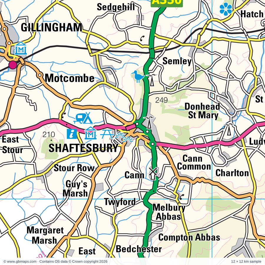
Shaftesbury regional road map. Full 60 × 60 km PDF, SVG and Illustrator files, with a free PDF sample.

GBMAPS.COM

Shaftesbury Regional Road Map

Call Us Now for Help01751 473136

GREAT BRITAIN ROAD ATLAS · 1:250,000 GB-390-0120

Shaftesbury & surrounding area

Explore the full 60 × 60 km Shaftesbury regional road map at 1:250,000, covering Shaftesbury, Gillingham, Mere, Stalbridge, Verwood. Compare the complete coverage below; a detailed PDF sample is available free.

SHAFTESBURY & SURROUNDING AREAREGIONAL ROAD MAP
60 × 60 km · Full map previewDownload the free SVG ↓

INSIDE THE FULL 60 × 60 KM MAP

Explore the Shaftesbury map area

1:250,000 cartography

Towns, villages & places

More mapped places (275)
  • Ludwell
  • Cann
  • Compton Abbas
  • Twyford
  • Bedchester
  • Stubhampton
  • Semley
  • Woodcutts
  • Motcombe
  • Minchington
  • Stour Row
  • Iwerne Courtney
  • Alvediston
  • Chettle
  • Sedgehill
  • Ansty
  • Dean
  • Newtown
  • Deanland
  • West End
  • Manston
  • Swallowcliffe
  • Cashmoor
  • Hammoon
  • Todber
  • Tisbury
  • Pimperne
  • Woodminton
  • Stourpaine
  • Fiddleford
  • Shillingstone
  • Chicksgrove
  • Marnhull
  • Durweston
  • Bowerchalke
  • Fifield Bavant
  • Hindon
  • Woodyates
  • Mead End
  • Ridge
  • Broad Oak
  • Bryanston
  • Huntingford
  • Fovant
  • Pentridge
  • Manswood
  • Chilmark
  • Turnworth
  • Chicklade
  • Silton
  • Dinton
  • Cucklington
  • Witchampton
  • Bourton
  • Martin
  • Ibberton
  • Zeals
  • Cranborne
  • Lydlinch
  • Thornicombe
  • Baverstock
  • Henstridge
  • Woolland
  • Chalbury
  • Tidpit
  • Penselwood
  • Horton
  • Spetisbury
  • Woodlands
  • Stourton
  • Yenston
  • Shapwick
  • Stanbridge
  • Templecombe
  • Gaunts
  • Bishopstone
  • King's Stag
  • Stockton
  • Sherrington
  • Horsington
  • Bapton
  • Burcombe
  • Boyton
  • Holt
  • Wylye
  • Kilmington
  • Winterborne Whitechurch
  • Hilton
  • Higher Ansty
  • Clapgate
  • Corton
  • Damerham
  • Tytherington
  • Almer
  • Lower Street
  • Mappowder
  • Deptford
  • Holwell
  • Rockbourne
  • Lower Ansty
  • Mannington
  • Cowgrove
  • Pamphill
  • North Cheriton
  • Broom Hill
  • Stowell
  • Knook
  • Holt Heath
  • Pulham
  • Holton
  • Goathill
  • Netherhampton
  • Whitsbury
  • Hardway
  • Anderson
  • Heytesbury
  • Alderholt
  • Crockerton
  • Sandleheath
  • Homington
  • Horningsham
  • Norton Bavant
  • Haydon
  • Bishopstrow
  • Quidhampton
  • Redlynch
  • Stoford
  • Alweston
  • Duntish
  • Stapleford
  • Ashford
  • Cheselbourne
  • Oborne
  • North Brewham
  • Merley
  • East Morden
  • Folke
  • Blackford
  • Dewlish
  • Poyntington
  • Odstock
  • Bloxworth
  • Breamore
  • Bere Regis
  • Plush
  • Bickton
  • Chitterne
  • Hampreston
  • Holnest
  • Yarlington
  • Middlemarsh
  • Harbridge
  • Longburton
  • Ashley Heath
  • Nunton
  • Stuckton
  • Trickett's Cross
  • Britford
  • Slepe
  • Ibsley
  • Longham
  • Woodgreen
  • Ellingham
  • St Leonards
  • Bodenham
  • South Cadbury
  • Tolpuddle
  • St Ives
  • Corsley
  • Bearwood
  • Lane End
  • Hyde
  • Sutton Montis
  • Upton
  • Affpuddle
  • Lillington
  • Organford
  • Briantspuddle
  • Piddletrenthide
  • Godshill
  • Galhampton
  • Mockbeggar
  • Frogham
  • Hermitage
  • Trudoxhill
  • Blissford
  • Downton
  • Batcombe
  • Hale
  • Burleston
  • Blashford
  • Tytherington
  • Chapmanslade
  • Wanstrow
  • Ford
  • Lamyatt
  • Shrewton
  • Rimpton
  • Westcombe
  • Puddletown
  • Piddlehinton
  • Orcheston
  • North Charford
  • Up Cerne
  • Alderbury
  • Woodfalls
  • Sparkford
  • Lake
  • Whaddon
  • Nunney
  • Berkley
  • Thornford
  • Leigh
  • Linwood
  • Hangersley
  • Kingston
  • Wilsford
  • Tincleton
  • Leighton
  • Alhampton
  • Tilshead
  • Linford
  • Sutton
  • Bisterne
  • Evercreech
  • Nether Cerne
  • Ditcheat
  • Alford
  • Chesterblade
  • Whatley
  • Chetnole
  • Picket Post
  • Hurn
  • Batcombe
  • Avon
  • Woodsford
  • Chantry
  • Gomeldon
  • Cranmore
  • Godmanstone
  • Up Sydling
  • Dean
  • Porton
  • Downhead
  • Prestleigh
  • Mells
  • Forston
  • Wraxall
  • Ripley
  • Doulting
  • Stinsford
  • Idmiston
  • Sopley
  • Waterlip
  • Pylle
  • Vobster
  • Charminster
  • Burton
  • Durrington
  • Winkton
  • Coleford
  • Bulford
  • Stratton
  • Bransgore
  • Grimstone
  • Milston
  • Frampton
  • Figheldean
  • Holcombe
  • Netheravon
  • Oakhill
  • Nettlebridge
  • Fittleton
  • Ashwick
  • Binegar

Roads across this sheet

A30, A35, A37, A337, A338, A341, A345, A347, A348, A349, A350, A351, A352, A354, A356, A357, A359, A360, A361, A362, A367, A371, A3028, A3030

More road numbers

A3040, A3049, A3060, A3094, A3098, B390, B3059, B3061, B3063, B3064, B3065, B3066, B3067, B3068, B3072, B3073, B3074, B3075, B3078, B3080, B3081, B3082, B3083, B3085, B3086, B3089, B3090, B3091, B3092, B3093, B3095, B3099, B3135, B3136, B3139, B3142, B3143, B3144, B3145, B3146, B3147, B3148, B3150, B3152, B3153, B3159, B3347, B3356, B3369, B3390, B3414

Rivers & waterways

Moors River, River Allen, River Avon, River Bourne, River Brue, River Cale, River Cary, River Ebble, River Frome, River Lydden, River Nadder, River Piddle or Trent

More waterways

River Stour, River Wylye, River Yeo, Whitelake

Landmarks & landscape

Adventure Wonderland, Alderholt Mill, Alfred's Tower, Athelhampton House, Avon Heath Country Park, Badbury Rings, Binghams Melcombe, Blandford Forum Museum, Cavalcade of Costume, Blanford Forum Solar Park, Bournemouth Aviation Museum, Breamore Countryside Museum, Breamore House, NEW FOREST NATIONAL PARK

More named features

Bruton Museum, Bulford Kiwi, Bulford Kiwi (Hill Figure), Bush Farm Bison Centre, Cadbury Castle, Canada Farm Solar Park, Castle Cary Museum, Cerne Abbas Giant, Cerne Abbas Giant (Hill Figure), Chettle House, Christchurch Castle Keep and Motte, Christchurch Priory, Clouds Hill, Compton Chamberlain Military Badge, Constables House, Cranborne Common Nature Reserve, Cranborne Manor Gardens, Cuckoo Hill Railway, Deans Court Gardens, Dorset Heavy Horse and Animal Centre, Dorset Wildlife Trust Visitor Centre, Downton Moot, East Somerset Railway, Edmonsham House & Gardens, Farmer Giles' Farmstead, Farmer Palmer's Animal World, Fiddleford Manor, Fordingbridge Museum, Fovant Down Military Badges, Fovant Down Regimental Badges (Hill Figure), Frome Museum, Gants Mill and Garden, Gillingham Museum, Gorcombe Farm, Hardy's Cottage, Hardy's Birthplace Visitor Centre, Hauser & Wirth Somerset, Haynes Motor Museum, Heale House Garden, Hengistbury Head Nature Reserve, Hengistbury Head Visitor Centre, Homeland Solar Farm, Honeybrook Farm and Country Park, Kingsettle Wood, Kingston Lacy, Kingston Maurward, Knoll Gardens, Knowlton Church and Earthworks, Lamb Down Military Badge, Lamb Down Military Badge (Hill Figure), Larkhill Point to Point Racecourse, Larmer Tree Gardens, Liberty's Owl Raptor & Reptile Centre, Little Clarendon, Longleat House, Longleat House & Attractions, Longleat Safari Park, Maize Maze, Matchams Karting, Max Gate, Mere Museum, Milton Abbey, Minterne House Gardens, Mompesson House, Moors Valley Country Park, Moors Valley Railway, Go Ape Moors Valley, Moyles Court, Netheravon Dovecote, New Barn Field Centre, Nunney Castle, Old Castle, Old Sarum, Old Wardour Castle, Paradise Pastures Donkey Sanctuary, Parsonage Down Nature Reserve, Philipps House, Philipps House & Dinton Park, Place Mill, Stanpit Marsh Visitor Centre, Poole Museum, Old Lifeboat House, Scaplen's Court Museum, Purse Cundal Manor House, Pythouse Walled Garden, RNLI HQ, Poole Pottery, Redcoats Regimental Museum, Salisbury and South Wilts Museum, The John Creasey Museum, Secrets of Salisbury Medieval Hall, Ringwood Brewery, Ringwood Town and Country Experience, Rockbourne Roman Villa, Royal Bath and West of England Showground, Royal Signals Museum, Salisbury Arts Centre, Salisbury Cathedral, Salisbury Racecourse, Sandford Orcas Manor House, Shaftesbury Town Museum, Shaftesbury Abbey Museum and Gardens, Shear Water, Sherborne Castle and Gardens, Sherborne Old Castle, Sherborne Museum, Sherbourne Castle, Shillingstone Station, Solar Farm, Stonehenge, Stonehenge (World Heritage Site), Stonehenge Visitor Centre, Stourhead Gardens, Stourhead House, Stourton House Flower Gardens, Sturminster Newton Museum, Sutton Down Military Badges, The Courtyard Craft Centre, The Dewey Museum, The Nine Stones, The Priest's House Museum and Gardens, The Red House Museum and Gardens, The Studio, The Tolpuddle Martyrs Tree, Tolpuddle Martyrs Museum, Upton Country Park, Verwood Heritage Centre, Verwood Solar Farm, Visitor Centre, Walford Mill Craft Centre, Whistley Farm Solar Farm, White Mill, White Sheet Hill Nature Reserve, Wilton Carpet Factory, Wilton House & Gardens, Wincanton Racecourse, Windsor Farm Solar Farm, Wolfeton House, Woodhenge, Wylye Valley Vineyard
Local authority & parish coverage

Wholly or partly within the full map rectangle. These boundaries are coverage information, not additional artwork layers.

  • Bournemouth, Christchurch and PoolePartly within
  • DorsetPartly within
  • New Forest DistrictPartly within
  • SomersetPartly within
  • WiltshirePartly within
Wards & electoral divisions 121 areas
  • Alderney & Bourne Valley Ward
  • Beacon Ward
  • Bearwood & Merley Ward
  • Blackmore Vale Ward
  • Blandford Ward
  • Boscombe East & Pokesdown Ward
  • Boscombe West Ward
  • Bournemouth Central Ward
  • Bransgore, Burley, Sopley & Ringwood East Ward (part)
  • Broadstone Ward
  • Burton & Grange Ward
  • Canford Cliffs Ward (part)
  • Canford Heath Ward
  • Chalk Valleys Ward
  • Charminster St. Mary's Ward
  • Christchurch Town Ward
  • Colehill & Wimborne Minster East Ward
  • Commons Ward
  • Corfe Mullen Ward
  • Cranborne & Alderholt Ward
  • Cranborne Chase Ward
  • Creekmoor Ward
  • Dorchester East Ward (part)
  • Dorchester Poundbury Ward (part)
  • Dorchester West Ward (part)
  • Downlands & Forest North Ward (part)
  • East Cliff & Springbourne Ward
  • East Southbourne & Tuckton Ward
  • Eggardon Ward (part)
  • Ferndown North Ward
  • Ferndown South Ward
  • Fordingbridge, Godshill & Hyde Ward (part)
  • Gillingham Ward
  • Hamworthy Ward (part)
  • Highcliffe & Walkford Ward (part)
  • Hill Forts & Upper Tarrants Ward
  • Kinson Ward
  • Littledown & Iford Ward
  • Lytchett Matravers & Upton Ward
  • Moordown Ward
  • Mudeford, Stanpit & West Highcliffe Ward (part)
  • Muscliff & Strouden Park Ward
  • Newtown & Heatherlands Ward
  • Oakdale Ward
  • Parkstone Ward (part)
  • Penn Hill Ward (part)
  • Poole Town Ward (part)
  • Puddletown & Lower Winterborne Ward
  • Queen's Park Ward
  • Redhill & Northbourne Ward
  • Ringwood North & Ellingham Ward (part)
  • Ringwood South Ward
  • Shaftesbury Town Ward
  • Sherborne East Ward
  • Sherborne Rural Ward (part)
  • Sherborne West Ward
  • South East Purbeck Ward (part)
  • St. Leonards & St. Ives Ward
  • Stalbridge & Marnhull Ward
  • Stour & Allen Vale Ward
  • Sturminster Newton Ward
  • Talbot & Branksome Woods Ward
  • Verwood Ward
  • Wallisdown & Winton West Ward
  • Wareham Ward (part)
  • West Moors & Three Legged Cross Ward
  • West Parley Ward
  • West Purbeck Ward (part)
  • West Southbourne Ward
  • Westbourne & West Cliff Ward (part)
  • Wimborne Minster Ward
  • Winterborne & Broadmayne Ward (part)
  • Winterborne North Ward
  • Winton East Ward
  • Yetminster Ward (part)
  • Alderbury & Whiteparish ED (part)
  • Amesbury East & Bulford ED (part)
  • Amesbury South ED
  • Amesbury West ED
  • Avon Valley ED (part)
  • Blackmoor Vale ED
  • Castle Cary ED (part)
  • Devizes Rural West ED (part)
  • Downton & Ebble Valley ED (part)
  • Durrington ED
  • Ethandune ED (part)
  • Fovant & Chalke Valley ED
  • Frome East ED
  • Frome North ED (part)
  • Frome West ED (part)
  • Laverstock ED
  • Mendip Central and East ED (part)
  • Mendip Hills ED (part)
  • Mendip South ED (part)
  • Mere ED
  • Nadder Valley ED
  • Old Sarum & Lower Bourne Valley ED (part)
  • Pewsey Vale West ED (part)
  • Redlynch & Landford ED (part)
  • Salisbury Bemerton Heath ED
  • Salisbury Fisherton & Bemerton Village ED
  • Salisbury Harnham East ED
  • Salisbury Harnham West ED
  • Salisbury Milford ED
  • Salisbury St. Edmund's ED
  • Salisbury St. Francis & Stratford ED
  • Salisbury St. Paul's ED
  • Shepton Mallet ED (part)
  • The Lavingtons ED (part)
  • Till Valley ED (part)
  • Tisbury ED
  • Warminster Broadway ED
  • Warminster East ED
  • Warminster North & Rural ED
  • Warminster West ED
  • Westbury East ED (part)
  • Westbury West ED (part)
  • Wilton ED
  • Wincanton & Bruton ED
  • Winterslow & Upper Bourne Valley ED (part)
  • Wylye Valley ED (part)
Civil parishes & communities 369 areas
  • Abbas and Templecombe CP
  • Affpuddle and Turnerspuddle CP (part)
  • Alderbury CP (part)
  • Alderholt CP
  • Alford CP (part)
  • Allington CP (part)
  • Alton Pancras CP
  • Alvediston CP
  • Amesbury CP (part)
  • Anderson CP
  • Ansford CP
  • Ansty CP
  • Arne CP (part)
  • Ashmore CP
  • Ashwick CP
  • Athelhampton and Puddletown CP
  • Barford St. Martin CP
  • Batcombe CP
  • Batcombe CP
  • Beer Hackett CP (part)
  • Bere Regis CP (part)
  • Berkley CP (part)
  • Berwick St. James CP
  • Berwick St. John CP
  • Berwick St. Leonard CP
  • Binegar CP (part)
  • Bishop's Caundle CP
  • Bishopstone CP
  • Bishopstrow CP
  • Blandford Forum CP
  • Blandford St. Mary CP
  • Bloxworth CP
  • Bournemouth CP (part)
  • Bourton CP
  • Bowerchalke CP
  • Boyton CP
  • Bradford Peverell CP
  • Bransgore CP (part)
  • Bratton CP (part)
  • Bratton Seymour CP
  • Breamore CP
  • Brewham CP
  • Britford CP
  • Brixton Deverill CP
  • Broad Chalke CP
  • Broadstone CP
  • Bruton CP
  • Bryanston CP
  • Buckhorn Weston CP
  • Buckland Dinham CP (part)
  • Buckland Newton CP
  • Bulford CP (part)
  • Burcombe Without CP
  • Burleston and Tolpuddle CP
  • Burley CP (part)
  • Burton and Winkton CP
  • Cann CP
  • Castle Cary CP
  • Castleton CP (part)
  • Cattistock CP (part)
  • Caundle Marsh CP
  • Cerne Abbas CP
  • Chalbury CP
  • Chapmanslade CP
  • Charlton Horethorne CP
  • Charlton Marshall CP
  • Charlton Musgrove CP
  • Charlton St. Peter CP (part)
  • Charminster CP
  • Cheselbourne CP
  • Chetnole CP (part)
  • Chettle CP
  • Cheverell Magna CP (part)
  • Chicklade CP
  • Chilcompton CP (part)
  • Child Okeford CP
  • Chilmark CP
  • Chitterne CP
  • Christchurch CP
  • Clarendon Park CP (part)
  • Codford CP
  • Coleford CP (part)
  • Colehill CP
  • Compton Abbas CP
  • Compton Chamberlayne CP
  • Compton Pauncefoot CP
  • Compton Valence CP (part)
  • Coombe Bissett CP
  • Corfe Mullen CP
  • Corsley CP
  • Corton Denham CP
  • Coulston CP (part)
  • Cranborne CP
  • Cranmore CP
  • Crichel CP
  • Croscombe CP (part)
  • Cucklington CP
  • Damerham CP
  • Dewlish CP
  • Dilton Marsh CP (part)
  • Dinton CP
  • Ditcheat CP (part)
  • Donhead St. Andrew CP
  • Donhead St. Mary CP
  • Dorchester CP (part)
  • Doulting CP
  • Downhead CP
  • Downton CP (part)
  • Durnford CP
  • Durrington CP
  • Durweston CP
  • East Knoyle CP
  • East Orchard CP
  • East Pennard CP (part)
  • East Stoke CP (part)
  • East Stour CP
  • Ebbesborne Wake CP
  • Edington CP (part)
  • Edmondsham CP
  • Ellingham, Harbridge and Ibsley CP (part)
  • Emborough CP (part)
  • Enford CP (part)
  • Erlestoke CP (part)
  • Evercreech CP
  • Farnham CP
  • Ferndown Town CP
  • Fifehead Magdalen CP
  • Fifehead Neville CP
  • Figheldean CP (part)
  • Firsdown CP (part)
  • Fittleton cum Haxton CP (part)
  • Folke CP
  • Fonthill Bishop CP
  • Fonthill Gifford CP
  • Fontmell Magna CP
  • Fordingbridge CP
  • Fovant CP
  • Frampton CP
  • Frome CP
  • Frome St. Quintin CP (part)
  • Frome Vauchurch CP (part)
  • Gillingham CP
  • Glanvilles Wootton CP
  • Goathill CP
  • Godmanstone CP
  • Godshill CP (part)
  • Great Elm CP (part)
  • Great Wishford CP
  • Gussage All Saints CP
  • Gussage St. Michael CP
  • Hale CP (part)
  • Hammoon CP
  • Hanford CP
  • Haydon CP
  • Hazelbury Bryan CP
  • Henstridge CP
  • Hermitage CP
  • Heytesbury CP (part)
  • Highcliffe and Walkford CP (part)
  • Hilfield CP
  • Hilton CP
  • Hindon CP
  • Hinton CP
  • Hinton St. Mary CP
  • Holcombe CP (part)
  • Holnest CP
  • Holt CP
  • Holton CP
  • Holwell CP
  • Horningsham CP
  • Horsington CP
  • Horton CP
  • Hurn CP
  • Hyde CP (part)
  • Ibberton CP
  • Idmiston CP (part)
  • Iwerne Courtney or Shroton CP
  • Iwerne Minster CP
  • Iwerne Stepleton CP
  • Kilmington CP
  • Kingston Deverill CP
  • Kington Magna CP
  • Knook CP
  • Lamyatt CP
  • Langton Long Blandford CP
  • Laverstock CP
  • Leigh CP
  • Leigh-on-Mendip CP
  • Leweston CP
  • Lillington CP
  • Longbridge Deverill CP
  • Longburton CP
  • Lovington CP (part)
  • Lydlinch CP
  • Lytchett Matravers CP
  • Lytchett Minster and Upton CP
  • Maiden Bradley with Yarnfield CP
  • Maiden Newton CP (part)
  • Manston CP
  • Maperton CP
  • Mappowder CP
  • Margaret Marsh CP
  • Market Lavington CP (part)
  • Marnhull CP
  • Marston Magna CP (part)
  • Martin CP
  • Melbury Abbas CP
  • Melbury Bubb CP (part)
  • Melcombe Horsey CP
  • Mells CP (part)
  • Mere CP
  • Milborne Port CP
  • Milborne St. Andrew CP
  • Milston CP (part)
  • Milton Abbas CP
  • Milton Clevedon CP
  • Minterne Magna CP
  • Morden CP
  • Moreton CP (part)
  • Motcombe CP
  • Nether Cerne CP
  • Nether Compton CP (part)
  • Netheravon CP (part)
  • Netherhampton CP
  • North Barrow CP (part)
  • North Cadbury CP
  • North Cheriton CP
  • North Wootton CP
  • Norton Bavant CP
  • Nunney CP
  • Oborne CP
  • Odstock CP
  • Okeford Fitzpaine CP
  • Orcheston CP (part)
  • Pamphill CP
  • Pen Selwood CP
  • Piddlehinton CP
  • Piddletrenthide CP
  • Pilton CP (part)
  • Pimperne CP
  • Pitcombe CP
  • Pitton and Farley CP (part)
  • Poole CP (part)
  • Poyntington CP
  • Pulham CP
  • Purse Caundle CP
  • Pylle CP (part)
  • Queen Camel CP (part)
  • Quidhampton CP
  • Redlynch CP (part)
  • Rimpton CP (part)
  • Ringwood CP
  • Rockbourne CP
  • Rushall CP (part)
  • Salisbury CP
  • Sandford Orcas CP
  • Sandleheath CP
  • Sedgehill and Semley CP
  • Selwood CP (part)
  • Shaftesbury CP
  • Shapwick CP
  • Shepton Mallet CP (part)
  • Shepton Montague CP
  • Sherborne CP
  • Sherrington CP
  • Shillingstone CP
  • Shrewton CP
  • Silton CP
  • Sixpenny Handley and Pentridge CP
  • Sopley CP
  • South Barrow CP (part)
  • South Cadbury and Sutton Montis CP
  • South Newton CP
  • Sparkford CP (part)
  • Spetisbury CP
  • St. Cuthbert Out CP (part)
  • St. Leonards and St. Ives CP
  • Stalbridge CP
  • Stapleford CP
  • Steeple Langford CP
  • Stinsford CP
  • Stockton CP
  • Stoke St. Michael CP
  • Stoke Trister CP
  • Stoke Wake CP
  • Stour Provost CP
  • Stourpaine CP
  • Stourton Caundle CP
  • Stourton with Gasper CP
  • Stratford Toney CP
  • Stratton CP
  • Stratton on the Fosse CP (part)
  • Sturminster Marshall CP
  • Sturminster Newton CP
  • Sutton Mandeville CP
  • Sutton Veny CP
  • Sutton Waldron CP
  • Swallowcliffe CP
  • Sydling St. Nicholas CP
  • Tarrant Crawford CP
  • Tarrant Gunville CP
  • Tarrant Hinton CP
  • Tarrant Keyneston CP
  • Tarrant Launceston CP
  • Tarrant Monkton CP
  • Tarrant Rawston CP
  • Tarrant Rushton CP
  • Teffont CP
  • Thornford CP (part)
  • Throop and Holdenhurst CP
  • Tilshead CP (part)
  • Tincleton CP
  • Tisbury CP
  • Todber CP
  • Tollard Royal CP
  • Trent CP (part)
  • Trudoxhill CP
  • Turnworth CP
  • Up Cerne CP
  • Upavon CP (part)
  • Upton Lovell CP
  • Upton Noble CP
  • Upton Scudamore CP
  • Verwood CP
  • Wanstrow CP
  • Wareham St. Martin CP (part)
  • Warminster CP
  • West Bradley CP (part)
  • West Knighton CP (part)
  • West Knoyle CP
  • West Lavington CP (part)
  • West Moors CP
  • West Orchard CP
  • West Parley CP
  • West Stafford CP (part)
  • West Stour CP
  • West Tisbury CP
  • Westbury CP (part)
  • Whatley CP
  • Whitsbury CP
  • Wilsford cum Lake CP
  • Wilton CP
  • Wimborne Minster CP
  • Wimborne St. Giles CP
  • Wincanton CP
  • Winterborne Clenston CP
  • Winterborne Houghton CP
  • Winterborne Kingston CP
  • Winterborne Monkton CP (part)
  • Winterborne St. Martin CP (part)
  • Winterborne Stickland CP
  • Winterborne Whitechurch CP
  • Winterborne Zelston CP
  • Winterbourne Abbas CP (part)
  • Winterbourne CP
  • Winterbourne Steepleton CP (part)
  • Winterbourne Stoke CP
  • Witchampton CP
  • Witham Friary CP
  • Woodford CP
  • Woodgreen CP
  • Woodlands CP
  • Woodsford CP (part)
  • Wool CP (part)
  • Woolland CP
  • Wylye CP
  • Yarlington CP
  • Yetminster CP (part)
  • Zeals CP

Source: the GBMaps road atlas, OS Boundary-Line and postcode mapping datasets. Source editions are being checked for publication. Unmarked boundary names are wholly within the sheet; “part” means the map edge crosses the area.

Place lists are selected from the map source, not a complete gazetteer. Named features describe the cartography; visitor facilities and opening status are not verified. The free sample covers only 12 × 12 km of this larger sheet.

INSIDE YOUR DOWNLOAD

A proper road map, in useful formats

Road classifications, towns and villages, railways, rivers, landscape detail and tourist symbols, brought together in the GBMaps regional road atlas style.

PDF filePDFSVG fileSVGAdobe Illustrator AI fileAi

PDF for the finished map. SVG and layered Illustrator artwork for adapting colours, adding your own information and preparing designs.

THE FINISHED SHEET

Designed for print and presentation

Map coverage
60 × 60 km
Sample coverage
12 × 12 km
Print layout
A3 landscape · enlarged 1:250k cartography
Sheet furniture
Border, scale bar, key & north arrow

A few useful details

What changes when I select another square?

Select a surrounding square to bring it into the centre and reveal the maps around it. Each square is a different 60 × 60 km map. The preview, free sample and selected download change together. Neighbouring sheets overlap by 30 km so you can choose the coverage that suits you.

Is the free sample a vector map?

The on-page detail is an SVG. The free download is a separate 12 × 12 km PDF with a link to the full map. Please retain its copyright credits and product link when sharing it.

Can I buy a larger combined map?

These downloads are individual ready-made sheets. Contact GBMaps if you need a larger combined area.

FREE PDF SAMPLE

Your free map sample

Your free 12 × 12 km sample includes a link back to this map, so you can return for the full area whenever you need it.

Download free PDF sample ↓

Get your Shaftesbury map

Map download bundle

£24.00including VATOne payment

Pay securely

One payment. Your map stays open.

Your map download

Your map files

Preparing your download…

Checking your private download link…

Your map downloads

Already bought a map?

Find the downloads from your purchases.

Enter the email address you used at checkout. We’ll email you a private link to your available map downloads.