Portsmouth regional road map. Full 60 × 60 km PDF, SVG and Illustrator files, with a free PDF sample.

GBMAPS.COM

Portsmouth Regional Road Map

Call Us Now for Help01751 473136

GREAT BRITAIN ROAD ATLAS · 1:250,000 GB-450-0090

Portsmouth & surrounding area

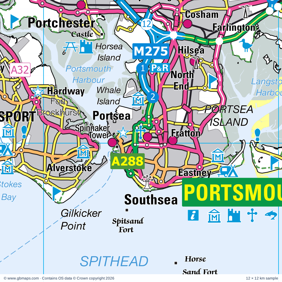
Explore the full 60 × 60 km Portsmouth regional road map at 1:250,000, covering Southampton, Newport, East Cowes, Cowes, Ryde. Compare the complete coverage below; a detailed PDF sample is available free.

PORTSMOUTH & SURROUNDING AREAREGIONAL ROAD MAP
60 × 60 km · Full map previewDownload the free SVG ↓

INSIDE THE FULL 60 × 60 KM MAP

Explore the Portsmouth map area

1:250,000 cartography

Towns, villages & places

More mapped places (165)

Roads across this sheet

M3, M27, M271, M275, A3, A3(M), A27, A31, A32, A33, A35, A36, A259, A288, A326, A334, A335, A336, A337, A397, A2030, A2047, A3020, A3021

More road numbers

A3023, A3024, A3025, A3035, A3051, A3054, A3055, A3056, A3057, A3090, B2141, B2146, B2147, B2148, B2149, B2150, B2151, B2152, B2154, B2155, B2177, B2179, B3033, B3035, B3036, B3037, B3038, B3039, B3043, B3053, B3054, B3055, B3056, B3058, B3076, B3078, B3079, B3080, B3320, B3321, B3322, B3323, B3325, B3326, B3327, B3328, B3329, B3330, B3331, B3333, B3334, B3340, B3341, B3342, B3354, B3385, B3395, B3397, B3399, B3401

Rivers & waterways

Beaulieu River, Lymington River, River Hamble, River Itchen, River Meon, River Test, River Yar, The Itchen Navigation

Landmarks & landscape

Adgestone Vineyard, Amazon World Zoo Park, Apple Court Gardens, Appuldurcombe House, Apse New Barn Solar Farm, Arreton Craft Village, Artsway, Beaulieu Abbey, Beaulieu Hotel, Bembridge Windmill, Bishop's Waltham Museum, Bishop's Waltham Palace, NEW FOREST NATIONAL PARK, SOUTH DOWNS NATIONAL PARK

More named features

Blackgang Chine Theme Park, Blackgang Sawmill & St Catherine's Quay, Blackwater Arboretum, Blue Reef Aquarium, Bolderwood Arboretum Ornamental Drive, Bolderwood Deer Sanctuary, Botley Mill, Brighstone Village Museum, Bucklers Hard Maritime Museum, Bursledon Brickworks, Butser Ancient Farm, Calshot Castle, Carisbrooke Castle, Chase Mill, Chawton Solar Farm, Chessell Pottery, Clanfield Pottery, Classic Boat Museum & Gallery, Coleman's Farm Park, Cowes Maritime Museum, Sir Max Aitken Museum, Delta Force, Dimbola Lodge Photographic Museum, Dinosaur Farm Museum, Dinosaur Isle, Diving Museum, Donkey Sanctuary, Isle of Wight Owl & Falconry Centre, Durrants Solar Farm, East Cowes Heritage Centre, Eastleigh Town Museum, Eastney Beam Engine House, Eastney Pumping Station Industrial Museum, D Day Museum, Eling Tide Mill, Totton and Eling Heritage Centre, Emsworth Museum, Exbury Gardens, Exbury Gardens Steam Railway, Farlington Marshes Nature Reserve, Flamingo Park, Appley Tower, Fort Brockhurst, Fort Nelson (Royal Armouries Museum of Artillery), Fort Victoria Country Park, Fort Victoria Marine Aquarium, Furzey Gardens, Glory Art Glass, Go Ape Itchen Valley, Godshill Model Village, Isle of Wight Natural History Centre, Golden Hill Fort Country Park, Gosport Gallery, Hall of Aviation, Tudor House, SeaCity, Hamptworth Lodge, Harting Downs Nature Reserve, Havant Arts Centre, Hayling Seaside Railway, Highcliffe Castle, Highcliffe Castle Visitor Centre, Holly Hill Woodland Park, Horse Sand Fort, Hurst Castle, Isle of Wight Bus & Coach Museum, Isle of Wight Butterfly World, Isle of Wight Lavender, Isle of Wight Museum of Geology, Isle of Wight Steam Railway (Tourist Railway), Isle of Wight Zoo, Itchen Valley Country Park, Knightwood Oak, Lakeside Country Park, Lepe Country Park, Lilliput Antique Doll & Toy Museum, Isle of Wight Wax Works, Longdown Activity Farm, Longshoreman's Museum, Ventnor Heritage Museum, Lymington-Keyhaven Nature Reserve, Manor Farm Country Park, Manor Farm and Country Park, Mary Rose, Charles Dickens Birthplace Museum, Royal Naval Museum, Medieval Merchant's House, Meon Valley Vineyard, Mottistone Manor Gardens, Museum, Museum of Island History, Needles Old Battery, Needles Pleasure Park, Nelson's Monument, Netley Abbey, New Forest Centre & Visitor Centre, New Forest Reptile Centre, New Forest Wildlife Park, New Forest Wine (Vineyard), Newlands Solar Farm, Newport Roman Villa, The Riverside Centre, Newtown National Nature Reserve, Newtown Old Town Hall, No Man's Land Fort, Northbrook Springs Vineyard, Nostalgia Toy Museum, Nunwell House, Osborne House, Out of Town Centre, Owl and Monkey Haven, Palace, Palace House, Paultons Park, Portchester Castle, Portsmouth Anglican Cathedral, Portsmouth City Museum and Art Gallery, Portsmouth Historic Dockyard, Spinnaker Tower, King James's Gate, Portsmouth RC Cathedral, Portsmouth Spinnaker Tower, Portuguese Fireplace, Quarr Abbey, Queen Elizabeth Country Park, Queen Elizabeth Country Park Visitor Centre, RN Submarine Museum, Gosport Museum, 17th Century Experience, Explosion Museum of Naval Firepower, Rhinefield Ornamental Drive, Robin Hill Adventure Park, Rossiters Vineyard, Royal Garrison Church, Portsmouth Landport Gate, Portsmouth King James Gate, Fort Cumberland, Royal Marines Museum, Cumberland House Natural History Museum, Royal Victoria Country Park, Rufus Stone, Rylstone Garden, Sammy Miller Motorcycle Museum, Sea Water Baths, Sharon Orchard, Rosemary Vineyard, Smallbrook Stadium, Solar Farm, Southsea Castle, Southsea Model Village, Spinners Garden, Spitsand Fort, Square Tower, St Barbe Museum, St Catherine's Oratory, St Helen's Fort, Stables Solar Farm, Stansted Park, Staunton Country Park, Swanwick Nature Reserve, Tennyson's Monument, The Hawthorns Urban Wildlife Centre, The Millais Gallery, Southampton Art Gallery, The National Motor Museum, The Park Centre, Royal Victoria Railway, The Shipwreck Centre and Maritime Museum, Titchfield Abbey, Uppark, Ventnor Botanic Gardens, Waltzing Waters Aqua Theatre, West Solent Solar Farm, Westbury Manor Museum, Wickham Vineyard, Wilmingham Solar Farm, Yarmouth Castle
Local authority & parish coverage

Wholly or partly within the full map rectangle. These boundaries are coverage information, not additional artwork layers.

  • Bournemouth, Christchurch and PoolePartly within
  • Chichester DistrictPartly within
  • City of PortsmouthWholly within
  • City of SouthamptonWholly within
  • East Hampshire DistrictPartly within
  • Eastleigh DistrictPartly within
  • Fareham DistrictWholly within
  • Gosport DistrictWholly within
  • Havant DistrictWholly within
  • Isle of WightWholly within
  • New Forest DistrictPartly within
  • Test Valley DistrictPartly within
  • WiltshirePartly within
  • Winchester DistrictPartly within
Wards & electoral divisions 178 areas
  • Alverstoke Ward
  • Anglesey Ward
  • Ashley, Bashley & Fernhill Ward
  • Ashurst, Bramshaw, Copythorne & Netley Marsh Ward
  • Avenue Ward
  • Baffins Ward
  • Ballard Ward
  • Banister & Polygon Ward
  • Bargate Ward
  • Barton & Becton Ward
  • Bassett Ward
  • Bedhampton Ward
  • Bevois Ward
  • Bishop's Waltham Ward (part)
  • Bishopstoke Ward (part)
  • Bitterne Park Ward
  • Blackwater Ward (part)
  • Botley Ward
  • Bransgore, Burley, Sopley & Ringwood East Ward (part)
  • Bridgemary Ward
  • Brockenhurst & Denny Lodge Ward
  • Brockhurst & Privett Ward
  • Buriton & East Meon Ward (part)
  • Bursledon & Hound North Ward
  • Central Meon Valley Ward (part)
  • Central Southsea Ward
  • Chandler's Ford Ward (part)
  • Charles Dickens Ward
  • Chilworth, Nursling & Rownhams Ward
  • Clanfield Ward
  • Copnor Ward
  • Cosham Ward
  • Cowplain Ward
  • Coxford Ward
  • Denmead Ward
  • Dibden & Dibden Purlieu Ward
  • Downlands & Forest North Ward (part)
  • Drayton and Farlington Ward
  • Eastleigh Central Ward
  • Eastleigh North Ward (part)
  • Eastleigh South Ward
  • Eastney and Craneswater Ward
  • Elson Ward
  • Emsworth Ward
  • Fair Oak & Horton Heath Ward (part)
  • Fareham Park Ward
  • Fareham Town Ward
  • Fawley, Blackfield, Calshot & Langley Ward
  • Fordingbridge, Godshill & Hyde Ward (part)
  • Forest & Solent Ward
  • Fort Fareham Ward
  • Forton Ward
  • Fratton Ward
  • Freemantle Ward
  • Grange & Alver Valley Ward
  • Hamble & Netley Ward
  • Harbour Villages Ward (part)
  • Harbourside & Town Ward
  • Hardley, Holbury & North Blackfield Ward
  • Hardway Ward
  • Harefield Ward
  • Hart Plain Ward
  • Harting Ward (part)
  • Havant St. Faith's Ward
  • Hayling East Ward
  • Hayling West Ward
  • Hedge End North Ward
  • Hedge End South Ward
  • Highcliffe & Walkford Ward (part)
  • Hill Head Ward
  • Hilsea Ward
  • Hook-with-Warsash Ward
  • Horndean Catherington Ward
  • Horndean Downs Ward
  • Horndean Kings & Blendworth Ward
  • Horndean Murray Ward
  • Hythe Central Ward
  • Hythe South Ward
  • Lavant Ward (part)
  • Lee East Ward
  • Lee West Ward
  • Leesland & Newtown Ward
  • Leigh Park Central & West Leigh Ward
  • Leigh Park Hermitage Ward
  • Locks Heath Ward
  • Lymington Ward
  • Lyndhurst & Minstead Ward
  • Marchwood & Eling Ward
  • Milford & Hordle Ward
  • Millbrook Ward
  • Milton Ward
  • Milton Ward
  • Mudeford, Stanpit & West Highcliffe Ward (part)
  • Nelson Ward
  • North Baddesley Ward (part)
  • Park Gate Ward
  • Paulsgrove Ward
  • Peartree Ward
  • Peel Common Ward
  • Pennington Ward
  • Portchester Castle Ward
  • Portchester Wicor Ward
  • Portswood Ward
  • Purbrook Ward
  • Redbridge Ward
  • Ringwood North & Ellingham Ward (part)
  • Romsey Abbey Ward (part)
  • Romsey Tadburn Ward (part)
  • Rowlands Castle Ward
  • Rowner & Holbrook Ward
  • Sarisbury & Whiteley Ward
  • Shirley Ward
  • Sholing Ward
  • Southbourne Ward
  • Southwick & Wickham Ward
  • St. Jude Ward
  • St. Thomas Ward
  • Stakes Ward
  • Stubbington Ward
  • Sway Ward
  • Swaythling Ward
  • The Witterings Ward (part)
  • Thornhill Ward
  • Titchfield Common Ward
  • Titchfield Ward
  • Totton Central Ward
  • Totton North Ward
  • Totton South Ward
  • Uplands & Funtley Ward
  • Upper Meon Valley Ward (part)
  • Valley Park Ward (part)
  • Wallington & Downend Ward
  • Waterloo Ward
  • West End North Ward
  • West End South Ward
  • Westbourne Ward (part)
  • Whiteley & Shedfield Ward
  • Woolston Ward
  • Bembridge ED
  • Binstead & Fishbourne ED
  • Brading & St. Helens ED
  • Brighstone, Calbourne & Shalfleet ED
  • Carisbrooke & Gunville ED
  • Central Rural ED
  • Chale, Niton & Shorwell ED
  • Cowes Medina ED
  • Cowes North ED
  • Cowes South & Northwood ED
  • Cowes West & Gurnard ED
  • East Cowes ED
  • Fairlee & Whippingham ED
  • Freshwater North & Yarmouth ED
  • Freshwater South ED
  • Haylands & Swanmore ED
  • Lake North ED
  • Lake South ED
  • Mountjoy & Shide ED
  • Nettlestone & Seaview ED
  • Newchurch, Havenstreet & Ashey ED
  • Newport Central ED
  • Newport West ED
  • Osborne ED
  • Pan & Barton ED
  • Parkhurst & Hunnyhill ED
  • Redlynch & Landford ED (part)
  • Ryde Appley & Elmfield ED
  • Ryde Monktonmead ED
  • Ryde North West ED
  • Ryde South East ED
  • Ryde West ED
  • Sandown North ED
  • Sandown South ED
  • Shanklin Central ED
  • Shanklin South ED
  • Totland & Colwell ED
  • Ventnor & St. Lawrence ED
  • Wootton Bridge ED
  • Wroxall, Lowtherville & Bonchurch ED
Civil parishes & communities 116 areas
  • Arreton CP
  • Ashurst and Colbury CP
  • Beaulieu CP
  • Bembridge CP
  • Bishops Waltham CP (part)
  • Bishopstoke CP (part)
  • Boarhunt CP
  • Boldre CP
  • Bosham CP (part)
  • Botley CP
  • Brading CP
  • Bramshaw CP
  • Bransgore CP (part)
  • Brighstone CP
  • Brockenhurst CP
  • Buriton CP (part)
  • Burley CP (part)
  • Bursledon CP
  • Calbourne, Newtown and Porchfield CP
  • Chale CP
  • Chandler's Ford CP (part)
  • Chidham and Hambrook CP (part)
  • Chillerton and Gatcombe CP
  • Chilworth CP
  • Clanfield CP
  • Compton CP (part)
  • Copythorne CP
  • Corhampton and Meonstoke CP (part)
  • Cowes CP
  • Curdridge CP
  • Denmead CP
  • Denny Lodge CP
  • Droxford CP (part)
  • Durley CP
  • East Boldre CP
  • East Cowes CP
  • East Meon CP (part)
  • East Wittering CP (part)
  • Eastleigh Town CP (part)
  • Ellingham, Harbridge and Ibsley CP (part)
  • Exbury and Lepe CP
  • Fair Oak and Horton Heath CP (part)
  • Fawley CP
  • Fishbourne CP
  • Freshwater CP
  • Funtington CP (part)
  • Godshill CP
  • Godshill CP (part)
  • Gurnard CP
  • Hale CP (part)
  • Hamble-le-Rice CP
  • Hambledon CP (part)
  • Harting CP (part)
  • Havenstreet and Ashey CP
  • Hedge End CP
  • Highcliffe and Walkford CP (part)
  • Hordle CP
  • Horndean CP
  • Hound CP
  • Hyde CP (part)
  • Hythe and Dibden CP
  • Lake CP
  • Landford CP (part)
  • Lymington and Pennington CP
  • Lyndhurst CP
  • Marchwood CP
  • Marden CP (part)
  • Melchet Park and Plaitford CP (part)
  • Milford-on-Sea CP
  • Minstead CP
  • Netley Marsh CP
  • Nettlestone and Seaview CP
  • New Milton CP
  • Newchurch CP
  • Newlands CP
  • Newport and Carisbrooke CP
  • Niton and Whitwell CP
  • North Baddesley CP (part)
  • Northwood CP
  • Nursling and Rownhams CP
  • Owslebury CP (part)
  • Redlynch CP (part)
  • Romsey CP (part)
  • Rookley CP
  • Rowlands Castle CP
  • Ryde CP
  • Sandown CP
  • Shalfleet CP
  • Shanklin CP
  • Shedfield CP
  • Shorwell CP
  • Soberton CP
  • Southbourne CP
  • Southwick and Widley CP
  • St. Helens CP
  • Stoughton CP (part)
  • Swanmore CP
  • Sway CP
  • Totland CP
  • Totton and Eling CP
  • Upham CP (part)
  • Valley Park CP (part)
  • Ventnor CP
  • Wellow CP (part)
  • West End CP
  • West Itchenor CP (part)
  • West Meon CP (part)
  • West Thorney CP
  • West Wittering CP (part)
  • Westbourne CP
  • Whippingham CP
  • Whiteley CP
  • Wickham and Knowle CP
  • Wootton Bridge CP
  • Wroxall CP
  • Yarmouth CP

Source: the GBMaps road atlas, OS Boundary-Line and postcode mapping datasets. Source editions are being checked for publication. Unmarked boundary names are wholly within the sheet; “part” means the map edge crosses the area.

Place lists are selected from the map source, not a complete gazetteer. Named features describe the cartography; visitor facilities and opening status are not verified. The free sample covers only 12 × 12 km of this larger sheet.

INSIDE YOUR DOWNLOAD

A proper road map, in useful formats

Road classifications, towns and villages, railways, rivers, landscape detail and tourist symbols, brought together in the GBMaps regional road atlas style.

PDF filePDFSVG fileSVGAdobe Illustrator AI fileAi

PDF for the finished map. SVG and layered Illustrator artwork for adapting colours, adding your own information and preparing designs.

THE FINISHED SHEET

Designed for print and presentation

Map coverage
60 × 60 km
Sample coverage
12 × 12 km
Print layout
A3 landscape · enlarged 1:250k cartography
Sheet furniture
Border, scale bar, key & north arrow

A few useful details

What changes when I select another square?

Select a surrounding square to bring it into the centre and reveal the maps around it. Each square is a different 60 × 60 km map. The preview, free sample and selected download change together. Neighbouring sheets overlap by 30 km so you can choose the coverage that suits you.

Is the free sample a vector map?

The on-page detail is an SVG. The free download is a separate 12 × 12 km PDF with a link to the full map. Please retain its copyright credits and product link when sharing it.

Can I buy a larger combined map?

These downloads are individual ready-made sheets. Contact GBMaps if you need a larger combined area.

FREE PDF SAMPLE

Your free map sample

Your free 12 × 12 km sample includes a link back to this map, so you can return for the full area whenever you need it.

Download free PDF sample ↓

Get your Portsmouth map

Map download bundle

£24.00including VATOne payment

Pay securely

One payment. Your map stays open.

Your map download

Your map files

Preparing your download…

Checking your private download link…

Your map downloads

Already bought a map?

Find the downloads from your purchases.

Enter the email address you used at checkout. We’ll email you a private link to your available map downloads.