Plymouth regional road map. Full 60 × 60 km PDF, SVG and Illustrator files, with a free PDF sample.

GBMAPS.COM

Plymouth Regional Road Map

Call Us Now for Help01751 473136

GREAT BRITAIN ROAD ATLAS · 1:250,000 GB-240-0060

Plymouth & surrounding area

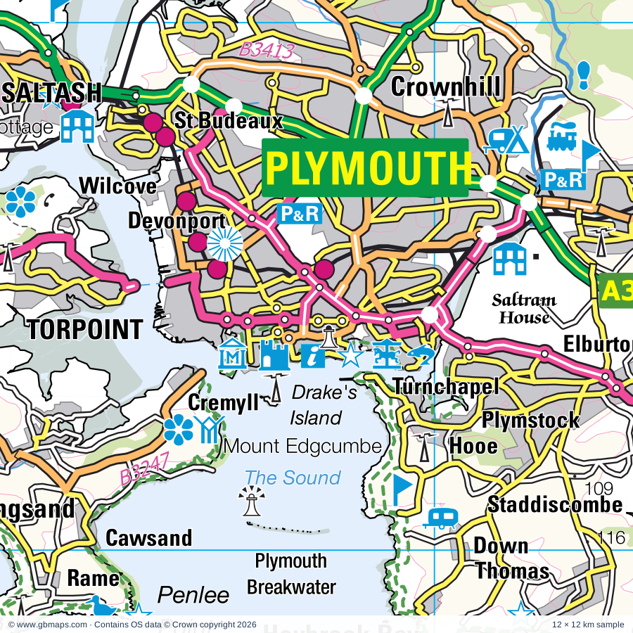
Explore the full 60 × 60 km Plymouth regional road map at 1:250,000, covering Saltash, Torpoint, Callington, Liskeard, Looe. Compare the complete coverage below; a detailed PDF sample is available free.

PLYMOUTH & SURROUNDING AREAREGIONAL ROAD MAP
60 × 60 km · Full map previewDownload the free SVG ↓

INSIDE THE FULL 60 × 60 KM MAP

Explore the Plymouth map area

1:250,000 cartography

Towns, villages & places

More mapped places (208)
  • St Germans
  • Tideford
  • Pillaton
  • Antony
  • St Mellion
  • Sheviock
  • Polbathic
  • St John
  • Blunts
  • Crafthole
  • Trerulefoot
  • Burraton
  • Portwrinkle
  • Bohetherick
  • St Dominick
  • Freathy
  • Bere Alston
  • Cremyll
  • Calstock
  • Newbridge
  • Hessenford
  • Harrowbarrow
  • Kingsand
  • Quethiock
  • Roborough
  • Cawsand
  • Downderry
  • Morwellham Quay
  • Rame
  • St Ann's Chapel
  • Seaton
  • St Ive
  • Menheniot
  • Widegates
  • Trevigro
  • Gunnislake
  • Bickleigh
  • Chilsworthy
  • Horningtops
  • Crapstone
  • Downgate
  • Clearbrook
  • Golberdon
  • Latchley
  • Merrymeet
  • Luckett
  • Plymstock
  • Walreddon
  • Morval
  • Staddiscombe
  • Trewidland
  • Yelverton
  • Pensilva
  • Heybrook Bay
  • Shaugh Prior
  • St Martin
  • Plympton
  • Horsebridge
  • Grenofen
  • Horrabridge
  • Sandplace
  • Wotter
  • Linkinhorne
  • Meavy
  • St Keyne
  • Tremar
  • Dousland
  • Walkhampton
  • Tredinnick
  • Duloe
  • Darite
  • Brixton
  • St Cleer
  • Lee Moor
  • Upton
  • Lamerton
  • Sheepstor
  • Minions
  • Rezare
  • Sparkwell
  • Treburley
  • Common Moor
  • Herodsfoot
  • Muchlarnick
  • Bathpool
  • Henwood
  • Dobwalls
  • Milton Abbot
  • Noss Mayo
  • Dunterton
  • Lutton
  • Longcross
  • Yealmpton
  • Trebullett
  • Lezant
  • Felldownhead
  • Pelynt
  • St Pinnock
  • Carey Park
  • Lee Mill
  • Cornwood
  • Larrick
  • Doublebois
  • Bradstone
  • Peter Tavy
  • Dunstone
  • Polperro
  • Merrivale
  • Kelly
  • Mary Tavy
  • Lanreath
  • Chillaton
  • Trebartha
  • Lawhitton
  • St Neot
  • Marystow
  • Westlake
  • Princetown
  • Horndon
  • Trenewan
  • Holbeton
  • Harford
  • Braddock
  • Whiteworks
  • Lewannick
  • Lansallos
  • Coryton
  • Ermington
  • Tinhay
  • Lifton
  • Couch's Mill
  • Boconnoc
  • Two Bridges
  • Liftondown
  • Portgate
  • Penpoll
  • Tregadillett
  • Polyphant
  • Warleggan
  • Lerryn
  • St Veep
  • Lewtrenchard
  • Kingston
  • Bittaford
  • Mount
  • Newmills
  • Lewdown
  • Fivelanes
  • Stowford
  • Modbury
  • Lydford
  • Bolventor
  • Altarnun
  • Trewen
  • Thrushelton
  • Ugborough
  • Golant
  • Langore
  • Hexworthy
  • Werrington
  • St Winnow
  • Didworthy
  • Temple
  • Yeolmbridge
  • Polruan
  • Ringmore
  • Cardinham
  • Combebow
  • Broadwoodwidger
  • Lescrow
  • Ladycross
  • Shortacombe
  • Laneast
  • Egloskerry
  • South Brent
  • Bigbury-on-Sea
  • Millpool
  • Bigbury
  • Dartmeet
  • Bridgetown
  • Brownston
  • Bellever
  • Tregeare
  • Ashford
  • St Clether
  • Langdon
  • Bantham
  • Bridestowe
  • Postbridge
  • Waterloo
  • Tresmeer
  • Buckland
  • Thurlestone
  • Tremaine
  • Treneglos
  • Outer Hope
  • Inner Hope
  • Galmpton
  • Hallworthy
  • Bolberry
  • Tremail
  • Davidstow
  • Tresinney
  • Trewassa
  • Valley Truckle
  • Gidleigh
  • Murchington
  • Wonson

Roads across this sheet

A39, A374, A379, A386, A387, A388, A390, A395, A3064, A3082, A3121, B3186, B3196, B3212, B3213, B3214, B3238, B3240, B3247, B3249, B3250, B3251, B3252, B3253

More road numbers

B3254, B3257, B3262, B3266, B3268, B3269, B3271, B3314, B3357, B3359, B3360, B3362, B3372, B3373, B3392, B3396, B3413, B3415, B3416, B3417, B3432

Rivers & waterways

De Lank River, East Dart River, East Okement River, River Avon, River Bovey, River Camel, River Carey, River Dart, River Erme, River Fowey, River Inny, River Lyd

More waterways

River Lynher, River Meavy, River Ottery, River Plym, River Seaton, River Tamar, River Tavy, River Taw, River Teign, River Thrushel, River Tiddy, River Walkham, River Wolf, River Yealm, St Neot River or River Loveny, West Dart River, West Okement River, West River Dart

Landmarks & landscape

Antique Chairs & Museum, Antony House, Antony Woodland Garden, Barbican Leisure Park, Brent Tor, Buckland Abbey, Buckland Abbey Garden, Burrator Discover Centre, Callington Town Museum, Carnglaze Caverns, City Museum and Art Gallery, Elizabethan House, Mayflower Exhibition, Cotehele, DARTMOOR NATIONAL PARK

More named features

Cotehele Estate (World Heritage Site), Cotehele House, Cotehele Quay Art and Craft Gallery, Cotehele Watermill, Cotehele Quay National Maritime Museum, Country Park, Cycle Trail, Daphne du Maurier's Smugglers at Jamaica, Dart Valley Nature Reserve, Dartmeet, Dartmoor Zoological Park, Davidstow Airfield & Cornwall at War Museum, Dingles Steam Village, Dupath Well, Dupath Well House, Filham Park, Fowey Aquarium, Fowey Museum, Furzeball Gardens, Golitha Falls, Grimspound, HM Prison Dartmoor Museum, Hidden Valley Adventure Park, Highmoorland Visitor Centre, Hurlers Stone Circles, Jamaica Inn, King Donert's Stone, King Doniert's Stone, Kit Hill (World Heritage Site), Lakeside Visitor Centre, Launceston Castle, Launceston Steam Railway, Lukesland Gardens, Lydford Castles and Saxon Town, Lydford Gorge and Waterfall, Magnificent Music Machines Museum, Mary Newmans Cottage, Merchants House Museum, Merrivale Prehistoric Settlement, Merrivale Stone Rows, Minions Heritage Centre, Morwellham Quay (World Heritage Site), Morwellham Quay Copper Mine, Garlandstone Historic Vessel, Mount Edgcumbe Country Park, Mount Edgcumbe Garden, National Marine Aquarium, New Mills Farm Park, Old Guildhall Museum, Penlee Battery Nature Reserve, Pinsla Garden, Plym Valley Railway, Plymouth Royal Citadel, Plympton Castle, Polperro Heritage Museum of Smuggling, Porfell Animal Land, Port Eliot House & Gardens, Postbridge National Park Visitor Centre, Queen Adelaide's Grotto, Restormel Castle, Saltash Heritage Collection, Saltram House, Smeaton's Tower, Plymouth Mayflower, Plymouth Gin Distillery Visitor Centre, Solar Farm, Southern Gallery, St Catherine's Castle, St Winnow Barton Farm Museum, Stuart House Arts & Heritage Centre, Liskeard & District Museum (World Heritage Site), Tamar Belle Heritage Centre, Tamar Otter Sanctuary, Tamar Trails Centre, Tamar Valley Donkey Park, Tavistock Museum, Tavistock Museum (World Heritage Site), The Arthurian Centre, The Barn Climbing Centre, The Garden House, The Hurlers, The Monkey Sanctuary, The Old Pump House, Trethevy Quoit, Trethorne Leisure Farm, Warleigh Solar Farm, Wembury Marine Centre, Wesley Cottage, Wheal Betsy Engine House
Local authority & parish coverage

Wholly or partly within the full map rectangle. These boundaries are coverage information, not additional artwork layers.

  • City of PlymouthWholly within
  • CornwallPartly within
  • South Hams DistrictPartly within
  • Teignbridge DistrictPartly within
  • Torridge DistrictPartly within
  • West Devon DistrictPartly within
Wards & electoral divisions 71 areas
  • Ashburton & Buckfastleigh Ward (part)
  • Bere Ferrers Ward
  • Bickleigh & Cornwood Ward
  • Bridestowe Ward (part)
  • Broadheath Ward (part)
  • Buckland Monachorum Ward
  • Budshead Ward
  • Burrator Ward
  • Chagford Ward (part)
  • Charterlands Ward (part)
  • Compton Ward
  • Dartmoor Ward (part)
  • Devonport Ward
  • Drake Ward
  • Drewsteignton Ward (part)
  • Efford and Lipson Ward
  • Eggbuckland Ward
  • Ermington & Ugborough Ward (part)
  • Ham Ward
  • Honicknowle Ward
  • Ivybridge East Ward
  • Ivybridge West Ward
  • Loddiswell & Aveton Gifford Ward (part)
  • Mary Tavy Ward
  • Milton Ford Ward
  • Moor View Ward
  • Moretonhampstead Ward (part)
  • Newton & Yealmpton Ward
  • Okehampton South Ward (part)
  • Peverell Ward
  • Plympton Chaddlewood Ward
  • Plympton Erle Ward
  • Plympton St. Mary Ward
  • Plymstock Dunstone Ward
  • Plymstock Radford Ward
  • Salcombe & Thurlestone Ward (part)
  • South Brent Ward (part)
  • South Tawton Ward (part)
  • Southway Ward
  • St. Budeaux Ward
  • St. Peter and the Waterfront Ward
  • Stoke Ward
  • Sutton and Mount Gould Ward
  • Tamarside Ward
  • Tavistock North Ward
  • Tavistock South East Ward
  • Tavistock South West Ward
  • Wembury & Brixton Ward
  • Woolwell Ward
  • Altarnun & Stoke Climsland ED
  • Bodmin St. Petroc's ED (part)
  • Callington & St. Dominic ED
  • Calstock ED
  • Camelford & Boscastle ED (part)
  • Fowey, Tywardreath & Par ED (part)
  • Lanivet, Blisland & Bodmin St. Lawrence ED (part)
  • Launceston North & North Petherwin ED (part)
  • Launceston South ED
  • Liskeard Central ED
  • Liskeard South & Dobwalls ED
  • Looe East & Deviock ED
  • Looe West, Pelynt, Lansallos & Lanteglos ED
  • Lostwithiel & Lanreath ED (part)
  • Lynher ED
  • Rame Peninsula & St. Germans ED
  • Saltash Essa ED
  • Saltash Tamar ED
  • Saltash Trematon & Landrake ED
  • St. Cleer & Menheniot ED
  • St. Teath & Tintagel ED (part)
  • Torpoint ED
Civil parishes & communities 149 areas
  • Advent CP (part)
  • Altarnun CP
  • Antony CP
  • Aveton Gifford CP (part)
  • Bere Ferrers CP
  • Bickleigh CP
  • Bigbury CP
  • Blisland CP (part)
  • Boconnoc CP
  • Bodmin CP (part)
  • Botusfleming CP
  • Braddock CP
  • Bradstone CP
  • Bratton Clovelly CP (part)
  • Brentor CP
  • Bridestowe CP (part)
  • Brixton CP
  • Broadwoodwidger CP (part)
  • Buckland Monachorum CP
  • Callington CP
  • Calstock CP
  • Camelford CP (part)
  • Cardinham CP (part)
  • Chagford CP (part)
  • Churchstow CP (part)
  • Cornwood CP
  • Coryton CP
  • Dartmoor Forest CP (part)
  • Davidstow CP
  • Dean Prior CP (part)
  • Deviock CP
  • Dobwalls CP
  • Duloe CP
  • Dunterton CP
  • Egloskerry CP
  • Ermington CP
  • Forrabury and Minster CP (part)
  • Fowey CP (part)
  • Gidleigh CP
  • Gulworthy CP
  • Harford CP
  • Helland CP (part)
  • Holbeton CP
  • Holne CP (part)
  • Horrabridge CP
  • Ivybridge CP
  • Kelly CP
  • Kingston CP
  • LCPs of Bridestowe and Sourton (part)
  • Lamerton CP
  • Landrake with St. Erney CP
  • Landulph CP
  • Laneast CP
  • Lanhydrock CP (part)
  • Lanlivery CP (part)
  • Lanreath CP
  • Lanteglos CP
  • Launceston CP
  • Lawhitton Rural CP
  • Lesnewth CP (part)
  • Lewannick CP
  • Lewtrenchard CP
  • Lezant CP
  • Lifton CP
  • Linkinhorne CP
  • Liskeard CP
  • Looe CP
  • Lostwithiel CP (part)
  • Lydford CP
  • Maker-with-Rame CP
  • Malborough CP (part)
  • Manaton CP (part)
  • Mary Tavy CP
  • Marystow CP
  • Meavy CP
  • Menheniot CP
  • Millbrook CP
  • Milton Abbot CP
  • Modbury CP (part)
  • Morval CP
  • Newton and Noss CP
  • North Bovey CP (part)
  • North Hill CP
  • North Huish CP (part)
  • North Petherwin CP (part)
  • Okehampton Hamlets CP (part)
  • Otterham CP (part)
  • Pelynt CP
  • Peter Tavy CP
  • Pillaton CP
  • Polperro CP
  • Quethiock CP
  • Ringmore CP
  • Saltash CP
  • Sampford Spiney CP
  • Shaugh Prior CP
  • Sheepstor CP
  • Sheviock CP
  • Sourton CP (part)
  • South Brent CP (part)
  • South Hill CP
  • South Huish CP (part)
  • South Milton CP (part)
  • South Petherwin CP
  • South Tawton CP (part)
  • Sparkwell CP
  • St. Breward CP (part)
  • St. Cleer CP
  • St. Clether CP
  • St. Dominick CP
  • St. Germans CP
  • St. Giles on the Heath CP (part)
  • St. Ive and Pensilva CP
  • St. John CP
  • St. Juliot CP (part)
  • St. Keyne and Trewidland CP
  • St. Martin-by-Looe CP
  • St. Mellion CP
  • St. Neot CP
  • St. Pinnock CP
  • St. Sampson CP (part)
  • St. Stephens By Launceston Rural CP
  • St. Thomas the Apostle Rural CP
  • St. Veep CP
  • St. Winnow CP (part)
  • Stokeclimsland CP
  • Stowford CP
  • Sydenham Damerel CP
  • Tavistock CP
  • Throwleigh CP (part)
  • Thrushelton CP (part)
  • Thurlestone CP (part)
  • Torpoint CP
  • Tremaine CP (part)
  • Tresmeer CP
  • Trevalga CP (part)
  • Trewen CP
  • Tywardreath and Par CP (part)
  • Ugborough CP (part)
  • Walkhampton CP
  • Warbstow CP (part)
  • Warleggan CP
  • Wembury CP
  • Werrington CP (part)
  • West Alvington CP (part)
  • West Buckfastleigh CP (part)
  • Whitchurch CP
  • Widecombe in the Moor CP (part)
  • Yealmpton CP

Source: the GBMaps road atlas, OS Boundary-Line and postcode mapping datasets. Source editions are being checked for publication. Unmarked boundary names are wholly within the sheet; “part” means the map edge crosses the area.

Place lists are selected from the map source, not a complete gazetteer. Named features describe the cartography; visitor facilities and opening status are not verified. The free sample covers only 12 × 12 km of this larger sheet.

INSIDE YOUR DOWNLOAD

A proper road map, in useful formats

Road classifications, towns and villages, railways, rivers, landscape detail and tourist symbols, brought together in the GBMaps regional road atlas style.

PDF filePDFSVG fileSVGAdobe Illustrator AI fileAi

PDF for the finished map. SVG and layered Illustrator artwork for adapting colours, adding your own information and preparing designs.

THE FINISHED SHEET

Designed for print and presentation

Map coverage
60 × 60 km
Sample coverage
12 × 12 km
Print layout
A3 landscape · enlarged 1:250k cartography
Sheet furniture
Border, scale bar, key & north arrow

A few useful details

What changes when I select another square?

Select a surrounding square to bring it into the centre and reveal the maps around it. Each square is a different 60 × 60 km map. The preview, free sample and selected download change together. Neighbouring sheets overlap by 30 km so you can choose the coverage that suits you.

Is the free sample a vector map?

The on-page detail is an SVG. The free download is a separate 12 × 12 km PDF with a link to the full map. Please retain its copyright credits and product link when sharing it.

Can I buy a larger combined map?

These downloads are individual ready-made sheets. Contact GBMaps if you need a larger combined area.

FREE PDF SAMPLE

Your free map sample

Your free 12 × 12 km sample includes a link back to this map, so you can return for the full area whenever you need it.

Download free PDF sample ↓

Get your Plymouth map

Map download bundle

£24.00including VATOne payment

Pay securely

One payment. Your map stays open.

Your map download

Your map files

Preparing your download…

Checking your private download link…

Your map downloads

Already bought a map?

Find the downloads from your purchases.

Enter the email address you used at checkout. We’ll email you a private link to your available map downloads.