Plymouth regional road map. Full 60 × 60 km PDF, SVG and Illustrator files, with a free PDF sample.

GBMAPS.COM

Plymouth Regional Road Map

Call Us Now for Help01751 473136

GREAT BRITAIN ROAD ATLAS · 1:250,000 GB-270-0060

Plymouth & surrounding area

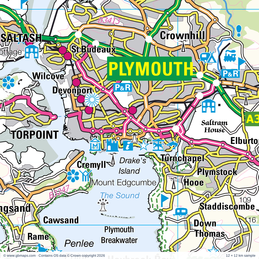
Explore the full 60 × 60 km Plymouth regional road map at 1:250,000, covering Buckfastleigh, Ivybridge, Totnes, Ashburton, Kingsbridge. Compare the complete coverage below; a detailed PDF sample is available free.

PLYMOUTH & SURROUNDING AREAREGIONAL ROAD MAP
60 × 60 km · Full map previewDownload the free SVG ↓

INSIDE THE FULL 60 × 60 KM MAP

Explore the Plymouth map area

1:250,000 cartography

Towns, villages & places

More mapped places (206)
  • Topsham
  • South Brent
  • Avonwick
  • Didworthy
  • Harbourneford
  • Diptford
  • Rattery
  • Bittaford
  • Ugborough
  • Bickham
  • Tigley
  • Harford
  • Belsford
  • Brownston
  • Harberton
  • Buckfast
  • Scorriton
  • Dartington
  • Harbertonford
  • Ermington
  • Modbury
  • Holne
  • Cornwood
  • Moreleigh
  • Westlake
  • Staverton
  • Halwell
  • Lutton
  • Lee Mill
  • Littlehempston
  • Ashford
  • Loddiswell
  • Broadhempston
  • Woodleigh
  • Poundsgate
  • Ashprington
  • Sparkwell
  • Tuckenhay
  • Allaleigh
  • Hutcherleigh
  • Woodland
  • Lee Moor
  • Holbeton
  • Venn
  • Woodford
  • Cornworthy
  • Hexworthy
  • Dartmeet
  • Dunstone
  • Kingston
  • Blackawton
  • Ponsworthy
  • Torbryan
  • Whiteworks
  • Bigbury
  • Churchstow
  • Caton
  • Millcombe
  • Yealmpton
  • Goveton
  • Wotter
  • Ringmore
  • Denbury
  • Ipplepen
  • Capton
  • East Cornworthy
  • Bickington
  • Sigford
  • Sheepstor
  • Shaugh Prior
  • Plympton
  • Buckland
  • Bigbury-on-Sea
  • Bantham
  • Brixton
  • Dittisham
  • Marldon
  • Harleston
  • Thurlestone
  • Princetown
  • Meavy
  • Compton
  • Two Bridges
  • Sherford
  • Bellever
  • Abbotskerswell
  • Bickleigh
  • Ilsington
  • Bowden
  • Haytor Vale
  • Woolston
  • Liverton
  • Dousland
  • Clearbrook
  • Frogmore
  • Strete
  • Slapton
  • Walkhampton
  • Noss Mayo
  • Kingskerswell
  • Chillington
  • Yelverton
  • Galmpton
  • Plymstock
  • Brimley
  • Postbridge
  • Outer Hope
  • Stoke Fleming
  • Stokenham
  • Malborough
  • Kingswear
  • Inner Hope
  • Teigngrace
  • Heathfield
  • Staddiscombe
  • Roborough
  • Coffinswell
  • Bolberry
  • Horrabridge
  • Crapstone
  • Hillhead
  • Ford
  • Merrivale
  • Preston
  • Daccombe
  • Manaton
  • Dunstone
  • Torcross
  • Beeson
  • Netherton
  • Beesands
  • Lustleigh
  • Heybrook Bay
  • Kellaton
  • Grenofen
  • Stokeinteignhead
  • Hallsands
  • Lettaford
  • Hennock
  • Walreddon
  • Bishopsteignton
  • Cremyll
  • Peter Tavy
  • Ideford
  • Bere Alston
  • Shaldon
  • Luton
  • Cargreen
  • Horndon
  • Trusham
  • Wilcove
  • Morwellham Quay
  • Coombe
  • Mary Tavy
  • Calstock
  • Doccombe
  • Kingsand
  • Murchington
  • Christow
  • Cawsand
  • Gidleigh
  • Carkeel
  • Easton
  • Bridford
  • Ashcombe
  • Bohetherick
  • Gunnislake
  • Rame
  • Holcombe
  • Botusfleming
  • Wonson
  • Burraton
  • St John
  • Lamerton
  • St Ann's Chapel
  • Doddiscombsleigh
  • Dunsford
  • Chilsworthy
  • Lydford
  • Shortacombe
  • Latchley
  • Dunchideock
  • Longcross
  • Horsebridge
  • Kenn
  • Kennford
  • Coryton
  • Cockwood
  • Chillaton
  • Bridestowe
  • Kenton
  • Marystow
  • Milton Abbot
  • Combebow
  • Starcross
  • Lewtrenchard
  • Powderham
  • Lewdown
  • Exminster
  • Thrushelton
  • Lympstone
  • Stowford
  • Portgate
  • Exton
  • Ebford
  • Broadwoodwidger

Roads across this sheet

M5, A374, A376, A379, A380, A381, A382, A383, A384, A385, A386, A388, A390, A3022, A3064, A3121, A3122, B3060, B3123, B3179, B3186, B3192, B3193, B3195

More road numbers

B3196, B3199, B3201, B3203, B3204, B3205, B3206, B3212, B3213, B3214, B3238, B3240, B3247, B3250, B3257, B3271, B3344, B3352, B3357, B3362, B3372, B3373, B3380, B3387, B3392, B3396, B3413, B3416, B3417, B3432

Rivers & waterways

East Dart River, East Okement River, Exeter Canal, River Avon, River Bovey, River Clyst, River Dart, River Erme, River Exe, River Kenn, River Lyd, River Meavy

More waterways

River Plym, River Tamar, River Tavy, River Taw, River Teign, River Thrushel, River Walkham, River Wolf, River Yealm, West Dart River, West Okement River, West River Dart

Landmarks & landscape

Antony House, Antony Woodland Garden, Ashburton Museum, Ashcombe Adventure Centre, Babbacombe Model Village, Barbican Leisure Park, Bayards Cove Castle, Becky Falls Beauty Spot, Berry Head Country Park, Berry Pomeroy Castle, Bishopsteignton Museum, Bradley Manor, DARTMOOR NATIONAL PARK

More named features

Brent Tor, Britannia Royal Naval College, Brixham Museum, Buckfast Abbey, Buckfast Butterfly Farm & Otter Sanctuary and Indoor RockClimbing, Buckland Abbey, Buckland Abbey Garden, Burrator Discover Centre, Bygones Museum, Canonteign Country Park, Canonteign Falls, Castle, Castle Drogo, Chilli Farm, China Blue, Church House, City Museum and Art Gallery, Elizabethan House, Mayflower Exhibition, Coleton Fishacre House & Garden, Compton Castle, Cookworthy Museum, Cotehele, Cotehele Estate (World Heritage Site), Cotehele House, Cotehele Quay Art and Craft Gallery, Cotehele Watermill, Cotehele Quay National Maritime Museum, Craft Centre, Dart Valley Nature Reserve, Dartington Cider Press Centre, Dartington Pottery, Dartington Hall, Dartmeet, Dartmoor Visitor Centre, Dartmoor Zoological Park, Dartmouth Castle, Dartmouth Museum, Dartmouth Pottery, Dawlish Museum, Dawlish Warren National Nature Reserve, Decoy Country Park, Devon Bird of Prey Centre, Devon Wildlife Centre & Hospital, Devon and Exeter Racecourse, Dingles Steam Village, Dunsford and Meadhaydown Wood Nature Reserve, East Dartmoor Woods and Heaths National Nature Reserve, East Slapton Ley National Nature Reserve, Fast Rabbit Farm, Filham Park, Follarton House Gardens and Aboretum, Go Ape Haldon Forest, Greenway, Grimspound, HM Prison Dartmoor Museum, Haldon Belvedere, Hallsands Ruined Village, Highmoorland Visitor Centre, Homeyards Botanical Gardens, Hound Tor, House of Marbles Glass and Teign Valley Glass, Kents Cavern, Kirkham House, Lakeside Visitor Centre, Lawrence Castle (Haldon Belvedere), Living Coasts, Lukesland Gardens, Lydford Castles and Saxon Town, Lydford Gorge and Waterfall, Mary Newmans Cottage, Merchants House Museum, Merrivale Prehistoric Settlement, Merrivale Stone Rows, Moretonhampstead Motor Museum, Morwellham Quay (World Heritage Site), Morwellham Quay Copper Mine, Garlandstone Historic Vessel, Mount Edgcumbe Country Park, Mount Edgcumbe Garden, National Marine Aquarium, Nature Reserve Visitor Centre, Newton Abbot Racecourse, Newton Abbot Town & GWR Museum, Occombe Farm Attraction, Operation Tiger Memorial, Orchid Paradise, Overbeck's Museum & Garden, Paignton Zoo, Paignton and Dartmouth Steam Railway (Tourist Railway), Penlee Battery Nature Reserve, Pennywell Farm & Wildlife Centre, Plant World Gardens, Plym Valley Railway, Plymouth Royal Citadel, Plympton Castle, Postbridge National Park Visitor Centre, Powderham Castle, Queen Adelaide's Grotto, Rare Breeds Farm, River Dart Country Park, Salcombe Maritime Museum, Saltash Heritage Collection, Saltram House, Seashore Centre, Quaywest Leisure Park, Shaldon Wildlife Trust, Sharpham Vineyard, Smeaton's Tower, Plymouth Mayflower, Plymouth Gin Distillery Visitor Centre, Solar Farm, South Devon Railway, St Lawrence Chapel Heritage, Cultural and Community Centre, Start Point Lighthouse, Stover Country Park, Interpretation Centre, Tamar Belle Heritage Centre, Tamar Trails Centre, Tamar Valley Donkey Park, Tavistock Museum, Tavistock Museum (World Heritage Site), Teignmouth Museum, The Garden House, The Old Pump House, The Rock Gardens, The Valiant Soldier Museum and Heritage Centre, Topsham Museum, Torquay Natural History Museum, Torre Abbey, Totnes Castle, Totnes Guildhall, Totnes Museum & Elizabethan House, Devonshire Collection Of Period Costume, Trago Mills Leisure Park, Tuckers Maltings, Ugbrooke House, Ugbrooke House and Gardens, Visitor Centre, Warleigh Solar Farm, Wembury Marine Centre, Wheal Betsy Engine House, Woodlands Leisure Park
Local authority & parish coverage

Wholly or partly within the full map rectangle. These boundaries are coverage information, not additional artwork layers.

  • City of PlymouthWholly within
  • CornwallPartly within
  • East Devon DistrictPartly within
  • Exeter DistrictPartly within
  • South Hams DistrictWholly within
  • Teignbridge DistrictPartly within
  • TorbayWholly within
  • Torridge DistrictPartly within
  • West Devon DistrictPartly within
Wards & electoral divisions 112 areas
  • Allington & Strete Ward
  • Alphington Ward (part)
  • Ambrook Ward
  • Ashburton & Buckfastleigh Ward
  • Barton with Watcombe Ward
  • Bere Ferrers Ward
  • Bickleigh & Cornwood Ward
  • Bishopsteignton Ward
  • Blackawton & Stoke Fleming Ward
  • Bovey Ward
  • Bradley Ward
  • Bridestowe Ward (part)
  • Broadheath Ward (part)
  • Buckland & Milber Ward
  • Buckland Monachorum Ward
  • Budshead Ward
  • Burrator Ward
  • Bushell Ward
  • Chagford Ward (part)
  • Charterlands Ward
  • Chudleigh Ward
  • Churston with Galmpton Ward
  • Clifton with Maidenway Ward
  • Clyst Valley Ward (part)
  • Cockington with Chelston Ward
  • Collaton St. Mary Ward
  • College Ward
  • Compton Ward
  • Dartington & Staverton Ward
  • Dartmoor Ward (part)
  • Dartmouth & East Dart Ward
  • Dawlish North East Ward
  • Dawlish South West Ward
  • Devonport Ward
  • Drake Ward
  • Drewsteignton Ward (part)
  • Efford and Lipson Ward
  • Eggbuckland Ward
  • Ellacombe Ward
  • Ermington & Ugborough Ward
  • Exmouth Halsdon Ward (part)
  • Exmouth Town Ward (part)
  • Furzeham with Summercombe Ward
  • Goodrington with Roselands Ward
  • Ham Ward
  • Haytor Ward
  • Honicknowle Ward
  • Ipplepen Ward
  • Ivybridge East Ward
  • Ivybridge West Ward
  • Kenn Valley Ward (part)
  • Kenton & Starcross Ward
  • Kerswell-with-Combe Ward
  • King's Ash Ward
  • Kingsbridge Ward
  • Kingsteignton East Ward
  • Kingsteignton West Ward
  • Loddiswell & Aveton Gifford Ward
  • Marldon & Littlehempston Ward
  • Mary Tavy Ward
  • Milton Ford Ward (part)
  • Moor View Ward
  • Moretonhampstead Ward (part)
  • Newton & Yealmpton Ward
  • Okehampton South Ward (part)
  • Peverell Ward
  • Plympton Chaddlewood Ward
  • Plympton Erle Ward
  • Plympton St. Mary Ward
  • Plymstock Dunstone Ward
  • Plymstock Radford Ward
  • Preston Ward
  • Priory Ward (part)
  • Roundham with Hyde Ward
  • Salcombe & Thurlestone Ward
  • Shaldon & Stokeinteignhead Ward
  • Shiphay Ward
  • South Brent Ward
  • South Tawton Ward (part)
  • Southway Ward
  • St. Budeaux Ward
  • St. Marychurch Ward
  • St. Peter and the Waterfront Ward
  • St. Peter's with St. Mary's Ward
  • Stoke Ward
  • Stokenham Ward
  • Sutton and Mount Gould Ward
  • Tamarside Ward (part)
  • Tavistock North Ward
  • Tavistock South East Ward
  • Tavistock South West Ward
  • Teign Valley Ward (part)
  • Teignmouth Central Ward
  • Teignmouth East Ward
  • Teignmouth West Ward
  • Topsham Ward (part)
  • Tormohun Ward
  • Totnes Ward
  • Wellswood Ward
  • Wembury & Brixton Ward
  • West Dart Ward
  • Woodbury & Lympstone Ward (part)
  • Woolwell Ward
  • Altarnun & Stoke Climsland ED (part)
  • Callington & St. Dominic ED (part)
  • Calstock ED (part)
  • Lynher ED (part)
  • Rame Peninsula & St. Germans ED (part)
  • Saltash Essa ED
  • Saltash Tamar ED
  • Saltash Trematon & Landrake ED (part)
  • Torpoint ED
Civil parishes & communities 164 areas
  • Abbotskerswell CP
  • Antony CP (part)
  • Ashburton CP
  • Ashcombe CP
  • Ashprington CP
  • Ashton CP
  • Aveton Gifford CP
  • Bere Ferrers CP
  • Berry Pomeroy CP
  • Bickington CP
  • Bickleigh CP
  • Bigbury CP
  • Bishopsteignton CP
  • Blackawton CP
  • Botusfleming CP (part)
  • Bovey Tracey CP
  • Bradstone CP (part)
  • Bratton Clovelly CP (part)
  • Brentor CP
  • Bridestowe CP (part)
  • Bridford CP
  • Brixham CP
  • Brixton CP
  • Broadhempston CP
  • Broadwoodwidger CP (part)
  • Buckfastleigh CP
  • Buckland Monachorum CP
  • Buckland in the Moor CP
  • Buckland-Tout-Saints CP
  • Calstock CP (part)
  • Chagford CP (part)
  • Charleton CP
  • Chivelstone CP
  • Christow CP
  • Chudleigh CP
  • Churchstow CP
  • Clyst St. George CP (part)
  • Clyst St. Mary CP (part)
  • Coffinswell CP
  • Cornwood CP
  • Cornworthy CP
  • Coryton CP
  • Dartington CP
  • Dartmoor Forest CP (part)
  • Dartmouth CP
  • Dawlish CP
  • Dean Prior CP
  • Denbury and Torbryan CP
  • Diptford CP
  • Dittisham CP
  • Doddiscombsleigh CP
  • Drewsteignton CP (part)
  • Dunchideock CP
  • Dunsford CP (part)
  • East Allington CP
  • East Portlemouth CP
  • Ermington CP
  • Exminster CP
  • Exmouth CP (part)
  • Frogmore and Sherford CP
  • Gidleigh CP
  • Gulworthy CP
  • Haccombe with Combe CP
  • Halwell and Moreleigh CP
  • Harberton CP
  • Harford CP
  • Hennock CP
  • Holbeton CP
  • Holcombe Burnell CP (part)
  • Holne CP
  • Horrabridge CP
  • Ide CP (part)
  • Ideford CP
  • Ilsington CP
  • Ipplepen CP
  • Ivybridge CP
  • Kelly CP (part)
  • Kenn CP
  • Kenton CP
  • Kingsbridge CP
  • Kingskerswell CP
  • Kingsteignton CP
  • Kingston CP
  • Kingswear CP
  • LCPs of Bridestowe and Sourton (part)
  • Lamerton CP
  • Landulph CP (part)
  • Lewtrenchard CP
  • Lifton CP (part)
  • Littlehempston CP
  • Loddiswell CP
  • Lustleigh CP
  • Lydford CP
  • Lympstone CP (part)
  • Maker-with-Rame CP
  • Malborough CP
  • Mamhead CP
  • Manaton CP
  • Marldon CP
  • Mary Tavy CP
  • Marystow CP
  • Meavy CP
  • Millbrook CP
  • Milton Abbot CP (part)
  • Modbury CP
  • Moretonhampstead CP (part)
  • Newton Abbot CP
  • Newton and Noss CP
  • North Bovey CP
  • North Huish CP
  • Ogwell CP
  • Okehampton Hamlets CP (part)
  • Peter Tavy CP
  • Pillaton CP (part)
  • Powderham CP
  • Rattery CP
  • Ringmore CP
  • Salcombe CP
  • Saltash CP (part)
  • Sampford Spiney CP
  • Shaldon CP
  • Shaugh Prior CP
  • Sheepstor CP
  • Shillingford St. George CP
  • Slapton CP
  • Sourton CP (part)
  • South Brent CP
  • South Huish CP
  • South Milton CP
  • South Pool CP
  • South Tawton CP (part)
  • Sparkwell CP
  • St. Dominick CP (part)
  • St. John CP (part)
  • Starcross CP
  • Staverton CP
  • Stoke Fleming CP
  • Stoke Gabriel CP
  • Stokeclimsland CP (part)
  • Stokeinteignhead CP
  • Stokenham CP
  • Stowford CP (part)
  • Strete CP
  • Sydenham Damerel CP (part)
  • Tavistock CP
  • Teigngrace CP
  • Teignmouth CP
  • Throwleigh CP (part)
  • Thrushelton CP (part)
  • Thurlestone CP
  • Torpoint CP
  • Totnes CP
  • Trusham CP
  • Ugborough CP
  • Walkhampton CP
  • Wembury CP
  • West Alvington CP
  • West Buckfastleigh CP
  • Whitchurch CP
  • Widecombe in the Moor CP
  • Woodbury CP (part)
  • Woodland CP
  • Woodleigh CP
  • Yealmpton CP

Source: the GBMaps road atlas, OS Boundary-Line and postcode mapping datasets. Source editions are being checked for publication. Unmarked boundary names are wholly within the sheet; “part” means the map edge crosses the area.

Place lists are selected from the map source, not a complete gazetteer. Named features describe the cartography; visitor facilities and opening status are not verified. The free sample covers only 12 × 12 km of this larger sheet.

INSIDE YOUR DOWNLOAD

A proper road map, in useful formats

Road classifications, towns and villages, railways, rivers, landscape detail and tourist symbols, brought together in the GBMaps regional road atlas style.

PDF filePDFSVG fileSVGAdobe Illustrator AI fileAi

PDF for the finished map. SVG and layered Illustrator artwork for adapting colours, adding your own information and preparing designs.

THE FINISHED SHEET

Designed for print and presentation

Map coverage
60 × 60 km
Sample coverage
12 × 12 km
Print layout
A3 landscape · enlarged 1:250k cartography
Sheet furniture
Border, scale bar, key & north arrow

A few useful details

What changes when I select another square?

Select a surrounding square to bring it into the centre and reveal the maps around it. Each square is a different 60 × 60 km map. The preview, free sample and selected download change together. Neighbouring sheets overlap by 30 km so you can choose the coverage that suits you.

Is the free sample a vector map?

The on-page detail is an SVG. The free download is a separate 12 × 12 km PDF with a link to the full map. Please retain its copyright credits and product link when sharing it.

Can I buy a larger combined map?

These downloads are individual ready-made sheets. Contact GBMaps if you need a larger combined area.

FREE PDF SAMPLE

Your free map sample

Your free 12 × 12 km sample includes a link back to this map, so you can return for the full area whenever you need it.

Download free PDF sample ↓

Get your Plymouth map

Map download bundle

£24.00including VATOne payment

Pay securely

One payment. Your map stays open.

Your map download

Your map files

Preparing your download…

Checking your private download link…

Your map downloads

Already bought a map?

Find the downloads from your purchases.

Enter the email address you used at checkout. We’ll email you a private link to your available map downloads.