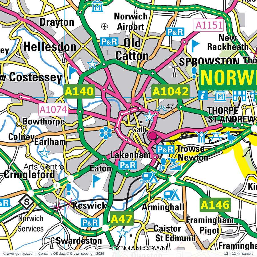
Norwich regional road map. Full 60 × 60 km PDF, SVG and Illustrator files, with a free PDF sample.

GBMAPS.COM

Norwich Regional Road Map

Call Us Now for Help01751 473136

GREAT BRITAIN ROAD ATLAS · 1:250,000 GB-630-0300

Norwich & surrounding area

Explore the full 60 × 60 km Norwich regional road map at 1:250,000, covering Loddon, Bungay, Beccles, Harleston, Gorleston-on-Sea. Compare the complete coverage below; a detailed PDF sample is available free.

NORWICH & SURROUNDING AREAREGIONAL ROAD MAP
60 × 60 km · Full map previewDownload the free SVG ↓

INSIDE THE FULL 60 × 60 KM MAP

Explore the Norwich map area

1:250,000 cartography

Towns, villages & places

More mapped places (361)
  • Thurton
  • Seething
  • Ashby St Mary
  • Hellington
  • Poringland
  • Mundham
  • Sisland
  • Rockland St Mary
  • Claxton
  • Bramerton
  • Shotesham
  • Kirby Bedon
  • Woodton
  • Chedgrave
  • Arminghall
  • Surlingham
  • Langley Street
  • Hedenham
  • Topcroft
  • Dunston
  • Postwick
  • Swainsthorpe
  • Hempnall
  • Hales
  • Buckenham
  • Topcroft Street
  • Brundall
  • Newton Flotman
  • Hassingham
  • Cantley
  • Strumpshaw
  • Ditchingham
  • Broome
  • Keswick
  • Raveningham
  • Ellingham
  • Blofield
  • Tasburgh
  • Swardeston
  • Limpenhoe
  • Fritton
  • Stockton
  • Mulbarton
  • Lingwood
  • Morningthorpe
  • Earsham
  • Southwood
  • Beighton
  • Thorpe End
  • Flordon
  • Thurlton
  • Mettingham
  • Denton
  • Cringleford
  • Bracon Ash
  • Reedham
  • Shelton
  • Freethorpe
  • Geldeston
  • Hemblington
  • Tharston
  • Maypole Green
  • Hapton
  • Shipmeadow
  • Hardwick
  • Flixton
  • Halvergate
  • Alburgh
  • North Green
  • Wickhampton
  • Thorpe
  • Gillingham
  • Toft Monks
  • Colney
  • Panxworth
  • Salhouse
  • Damgate
  • Barsham
  • South Walsham
  • Tunstall
  • Wreningham
  • Haddiscoe
  • Ketteringham
  • Homersfield
  • Fundenhall
  • Acle
  • Wacton
  • Wortwell
  • Bush Green
  • Woodbastwick
  • Ranworth
  • Hethersett
  • Ringsfield
  • St Olaves
  • Upton
  • Spixworth
  • Aldeby
  • Fritton
  • Ashwellthorpe
  • Tacolneston
  • Crostwick
  • Aslacton
  • Stokesby
  • Starston
  • Bawburgh
  • High Street
  • Silfield
  • Wheatacre
  • Mendham
  • Costessey
  • Wroxham
  • Worlingham
  • Herringfleet
  • Horning
  • Drayton
  • Somerleyton
  • Hoveton
  • Belton
  • Weston
  • Billockby
  • Frettenham
  • Belaugh
  • Clippesby
  • Stone Street
  • Redisham
  • Marlingford
  • Rumburgh
  • Bunwell
  • Tibenham
  • Ellough
  • Thurne
  • Horsford
  • Easton
  • Taverham
  • Metfield
  • Wramplingham
  • Needham
  • Runham
  • Rushall
  • Horstead
  • North Cove
  • Hainford
  • Hargate
  • Burgh St Margaret
  • Coltishall
  • Suton
  • Thrigby
  • Barford
  • Barnby
  • Ludham
  • Weybread
  • Lound
  • Repps
  • Waterloo
  • Ashmanhaugh
  • Shadingfield
  • Metfield Common
  • Filby
  • Mill Common
  • Bradwell
  • Spexhall
  • Gissing
  • Irstead
  • Neatishead
  • Tunstead
  • Wissett
  • Ringland
  • Bastwick
  • Sotterley
  • Mautby
  • Colton
  • Blundeston
  • Rollesby
  • Dickleburgh
  • Crownthorpe
  • Camps Heath
  • Mutford
  • Brockdish
  • Felthorpe
  • Brampton
  • Shimpling
  • Hopton on Sea
  • Wicklewood
  • Fressingfield
  • Honingham
  • Chediston
  • Thelveton
  • Barton Turf
  • Barnham Broom
  • Westhall
  • Rushmere
  • Kimberley
  • Pennygate
  • Catfield
  • Burston
  • Hevingham
  • Syleham
  • Haveringland
  • Scottow
  • Stoven
  • Buxton
  • Lamas
  • Martham
  • Badersfield
  • Winfarthing
  • Attlebridge
  • Henstead
  • Wingfield
  • Hackford
  • Gisleham
  • Smallburgh
  • Besthorpe
  • Corton
  • Morton
  • The Heath
  • Holton
  • Cratfield
  • Sloley
  • Coston
  • Uggeshall
  • Deopham
  • Cuckold's Green
  • Shelfanger
  • Cookley
  • Sutton
  • Billingford
  • Pixey Green
  • Swannington
  • Mells
  • Puddledock
  • Alderford
  • Scratby
  • Brampton
  • Runhall
  • Dilham
  • Welborne
  • Scole
  • Hardingham
  • Hickling
  • Hoxne
  • Worstead
  • Kessingland
  • West Somerton
  • Hemsby
  • Skeyton
  • Hockering
  • Walpole
  • Frostenden
  • Benacre
  • Marsham
  • California
  • Banham
  • Wrentham
  • Blyford
  • Huntingfield
  • Newport
  • Barnaby Green
  • Oakley
  • Ashfield Green
  • East Somerton
  • Wangford
  • Stradbroke
  • Mattishall
  • Westwick
  • Brandiston
  • Wenhaston
  • Denham
  • Stuston
  • Ubbeston
  • Heveningham
  • Winterton-on-Sea
  • Ingham
  • Lenwade
  • Laxfield
  • Eastgate
  • South Cove
  • Thuxton
  • Horsey
  • Honing
  • The Grove
  • Roydon
  • Bramfield
  • Tuttington
  • Thorington
  • Palgrave
  • Garvestone
  • Reymerston
  • Wilby
  • Wilby
  • Covehithe
  • Brome
  • Bressingham
  • Cawston
  • North Tuddenham
  • Horham
  • Fersfield
  • Blythburgh
  • Lyng
  • Brundish Street
  • Booton
  • Waxham
  • Kenninghall
  • Lessingham
  • Felmingham
  • Whitwell
  • Eccles Road
  • Quidenham
  • Elsing
  • Hempstead
  • Crostwight
  • Thrandeston
  • Sparham
  • Crown Corner
  • Sea Palling
  • Athelington
  • Reydon
  • Sibton
  • Whinburgh
  • Mill Street
  • Whimpwell Green
  • Banningham
  • Blickling
  • Redlingfield
  • Eccles on Sea
  • Yaxham
  • Ingworth
  • Salle
  • Yaxley
  • Wortham
  • Walberswick
  • Darsham
  • Woodgate
  • Occold
  • Braiseworth
  • Bawdeswell
  • Mellis
  • Oulton
  • Heydon
  • Redgrave
  • Foxley
  • Themelthorpe
  • Dunwich
  • Garboldisham
  • Botesdale
  • Billingford
  • Blo' Norton
  • Corpusty
  • Rickinghall
  • Hinderclay
  • Guestwick
  • Gislingham
  • Thelnetham
  • Candle Street
  • Thurning
  • Foulsham
  • Bintree
  • Twyford
  • Wattisfield
  • Hindolveston
  • Crownland
  • Four Ashes

Roads across this sheet

A11, A12, A47, A140, A143, A144, A145, A146, A147, A149, A1024, A1042, A1054, A1056, A1062, A1064, A1066, A1067, A1074, A1095, A1117, A1144, A1145, A1151

More road numbers

A1242, A1243, A1402, B1062, B1074, B1077, B1108, B1110, B1111, B1113, B1116, B1117, B1118, B1123, B1124, B1125, B1126, B1127, B1132, B1134, B1135, B1136, B1140, B1141, B1145, B1147, B1149, B1150, B1152, B1159, B1172, B1332, B1354, B1370, B1375, B1384, B1385, B1387, B1435, B1437, B1527, B1531, B1532

Rivers & waterways

Canal, Hundred Stream, Little Ouse River, North Walsham & Dilham Canal (disused), River Alde, River Ant, River Blyth, River Bure, River Chet, River Dove, River Thet, River Thurne

More waterways

River Tud, River Waveney, River Wensum, River Yare

Landmarks & landscape

100th Bomb Group Memorial Museum (USAF), Africa Alive, Alderfen Broad Nature Reserve, Banham Zoo, Barton Broad Nature Reserve, Beccles & District Museum, Benacre Nature Reserve, Berney Arms Nature Reserve, Bewilderwood, Bigods Castle, Blickling Hall, Blickling Hall Garden and Park, THE BROADS

More named features

Breydon Water Nature Reserve, Britannia Pier and Theatre, Wellington Pier and Theatre, Broadlands Art Centre, Bungay Castle (Bigods Castle), Bungay Museum, Bure Valley Railway, Burgh Castle, Burston Strike School, Buxton Heath Nature Reserve, Caister Castle Motor Museum, Caister Nova Scotia Solar Farm, Caister Roman Site, Caister-on-Sea Castle, Carlton Marches Wildlife Centre, Carlton Marshes Nature Reserve, Castle (rems of), Chediston Hall Solar Farm, City of Norwich Aviation Museum, Classic Rose Centre, Cow Tower, Dinosaur Adventure Park, Diss Museum, Dragon Hall, Dragon Hall, Assembly House, Dunwich Museum, East Anglian Transport Museum, East Ruston Old Vicarage Garden, Euroscope, Eye Castle, Fairhaven Gardens Trust, Forncett Industrial Steam Museum, Fritton Lake Country World, Garboldisham Windmill, Great Yarmouth Pleasure Beach, Great Yarmouth Racecourse, Great Yarmouth Sea Life Centre, Hales Hall, Halesworth & District Museum, Halesworth (Holton) Airfield Station 365 Memorial Museum, Hall, Hardley Windmill Visitor Centre, Harleston Town Museum, Herringfleet Drainage Mill, Hickling Broad National Nature Reserve, Hobland Hall, Horning Parish Staithe (West), Horning Parish Staithe (East), Mississippi Paddle Boat, Horsey Mere Drainage Mill, Horsey Mere Moorings, Hoveton Great Broad Nature Reserve, Hoveton Hall Gardens, How Hill/Reedham Marsh Nature Reserve, Ice Experience, Irstead Staithe Moorings, Kimberley House, Laxfield & District Museum, Lowestoft Museum, East Suffolk Maritime Museum, Lowestoft Memorial Museum, ISCA Maritime Museum, Ludham (Womack Staithe), Ludham Bridge Drainage Mill, Maritime Museum, Merrivale Model Village, Mid Yare Nature Reserve, Museum of the Broads, Neatishead Air Defence Radar Museum, Neatishead Moorings, Gay's Staithe Moorings, Nelson's Monument, Norfolk & Suffolk Aviation Museum, Norfolk Motor Cycle Museum, Norwich Arts Centre, Elm Hill, Pottergate Arts Centre, St Andrews Hall, Norwich Art Gallery, Norwich Cathedral, Oasis Camel Centre, Old Buckenham Windmill, Old Merchants House Row 117, Row 111 House, Greyfriars Cloisters, Paddy's Lane Barton Moorings, Pettitts Animal Adventure Park, Plantation Garden, Play Barn, Pleasurewood Hills Family Theme Park, Potter Heigham New Bridge Moorings, ROMAN FORT, Ranworth Broad Nature Reserve, Ranworth Staithe Visitor Centre, Raveningham Gardens, Redwings Horse Sanctuary, Royal Norfolk Showground, Sainsbury Centre for Visual Arts, Snetterton Motor Racing Circuit, Somerleyton Hall, Southwold Museum, The Amber Museum, Sailor Reading Room, Sparham Pools, St Olave's Priory, St Olaves Drainage Mill, Stanger's Hall Museum, Norwich Castle Museum, Royal Norfolk Regimental Museum, J Jarrold Printing Museum, Starston Windpump, Stracey Arms Drainage Mill, Strumpshaw Hall Steam Museum, Suffolk Apple Juice and Cider Press, Surlingham Broad Nature Reserve, Sutton (Windmill) Pottery, Sutton Staithe Moorings, Ted Ellis Nature Reserve, The Dell Garden, Thelnetham Windmill, Thrigby Hall Wildlife Gardens, Toad Hall Cottage Centre, Toad Hole Cottage, Tollhouse Museum, Elizabethan House Museum, Norfolk Nelson Museum, Time and Tide Museum, Potteries and Herring Smoking Museum, Herring Smoking Museum, Turf Fen Drainage Mill, USAAF 446th Bomb Group War Memorial, Upton Fen Nature Reserve, VENTA ICENORUM ROMAN TOWN, Venture Farm Animal Trust, Visitor Centre, Walberswick Nature Reserve, Waveney River Centre, Waveney Valley Railway and Nursery Line (Tourist Railway), Waxham Great Barn, West Somerton Moorings, Weston Longville Solar Farm, Whitlingham Country Park, Whittingham Marsh Nature Reserve, Whitwell & Reepham Railway, Wicklewood Cornmill, Winstanley Cats, Winterton Dunes Nature Reserve, Wite Slea Moorings, Heigham Sound, Wroxham Barns Craft & Farm Attraction, Wymondham Abbey, Wymondham Heritage Museum
Local authority & parish coverage

Wholly or partly within the full map rectangle. These boundaries are coverage information, not additional artwork layers.

  • Breckland DistrictPartly within
  • Broadland DistrictPartly within
  • East Suffolk DistrictPartly within
  • Great Yarmouth DistrictWholly within
  • Mid Suffolk DistrictPartly within
  • North Norfolk DistrictPartly within
  • Norwich DistrictWholly within
  • South Norfolk DistrictPartly within
  • West Suffolk DistrictPartly within
Wards & electoral divisions 136 areas
  • Acle Ward
  • All Saints & Wayland Ward (part)
  • Attleborough Burgh & Haverscroft Ward
  • Attleborough Queens & Besthorpe Ward
  • Aylsham Ward (part)
  • Bacton Ward (part)
  • Bacton Ward (part)
  • Barningham Ward (part)
  • Beccles & Worlingham Ward
  • Beck Vale, Dickleburgh & Scole Ward
  • Blofield with South Walsham Ward
  • Bowthorpe Ward
  • Bradwell North Ward
  • Bradwell South and Hopton Ward
  • Bressingham & Burston Ward
  • Brooke Ward
  • Brundall Ward
  • Bungay & Wainford Ward
  • Bunwell Ward
  • Burlingham Ward
  • Buxton Ward
  • Caister North Ward
  • Caister South Ward
  • Carlton & Whitton Ward
  • Carlton Colville Ward
  • Catton Grove Ward
  • Central And Northgate Ward
  • Central Wymondham Ward
  • Claydon Ward
  • Coltishall Ward
  • Cringleford Ward
  • Crome Ward
  • Debenham Ward (part)
  • Dereham Neatherd Ward (part)
  • Diss & Roydon Ward
  • Ditchingham & Earsham Ward
  • Drayton North Ward
  • Drayton South Ward
  • East Flegg Ward
  • Easton Ward
  • Eaton Ward
  • Erpingham Ward (part)
  • Eye Ward (part)
  • Eynesford Ward (part)
  • Fleggburgh Ward
  • Forncett Ward
  • Framlingham Ward (part)
  • Fressingfield Ward
  • Gislingham Ward (part)
  • Gorleston Ward
  • Great Witchingham Ward
  • Guiltcross Ward (part)
  • Gunton & St. Margarets Ward
  • Halesworth & Blything Ward
  • Happisburgh Ward (part)
  • Harbour & Normanston Ward
  • Harleston Ward
  • Harling & Heathlands Ward (part)
  • Hellesdon North West Ward
  • Hellesdon South East Ward
  • Hempnall Ward
  • Hethersett Ward
  • Hevingham Ward
  • Hickling Ward
  • Hingham & Deopham Ward (part)
  • Horsford and Felthorpe Ward
  • Hoveton & Tunstead Ward
  • Hoxne & Worlingworth Ward (part)
  • Kelsale & Yoxford Ward (part)
  • Kessingland Ward
  • Kirkley & Pakefield Ward
  • Lakenham Ward
  • Lincoln Ward (part)
  • Loddon & Chedgrave Ward
  • Lothingland Ward
  • Lothingland Ward
  • Magdalen Ward
  • Mancroft Ward
  • Marshes Ward
  • Mattishall Ward (part)
  • Mendlesham Ward (part)
  • Mile Cross Ward
  • Mulbarton & Stoke Holy Cross Ward
  • Nelson Ward
  • Nelson Ward
  • New Costessey Ward
  • Newton Flotman Ward
  • North Walsham East Ward (part)
  • North Walsham Market Cross Ward (part)
  • North Walsham West Ward (part)
  • North Wymondham Ward
  • Old Catton and Sprowston West Ward
  • Old Costessey Ward
  • Ormesby Ward
  • Oulton Broad Ward
  • Palgrave Ward (part)
  • Plumstead Ward
  • Poringland, Framinghams & Trowse Ward
  • Reepham Ward
  • Rickinghall Ward
  • Rockland Ward
  • Saham Toney Ward (part)
  • Sewell Ward
  • Shipdham-with-Scarning Ward (part)
  • South Wymondham Ward
  • Southtown and Cobholm Ward
  • Southwold Ward
  • Spixworth with St. Faiths Ward
  • Sprowston Central Ward
  • Sprowston East Ward
  • St. Andrews Ward
  • St. Benet's Ward
  • Stalham Ward
  • Stibbard Ward (part)
  • Stody Ward (part)
  • Stradbroke & Laxfield Ward (part)
  • Stratton Ward
  • Taverham North Ward
  • Taverham South Ward
  • The Buckenhams & Banham Ward
  • Thorpe Hamlet Ward
  • Thorpe St. Andrew North West Ward
  • Thorpe St. Andrew South East Ward
  • Thurlton Ward
  • Town Close Ward
  • Trunch Ward (part)
  • University Ward
  • Upper Wensum Ward (part)
  • Walsham-le-Willows Ward (part)
  • Wensum Ward
  • West Flegg Ward
  • Wicklewood Ward
  • Worstead Ward
  • Wrentham, Wangford & Westleton Ward (part)
  • Wroxham Ward
  • Yarmouth North Ward
Civil parishes & communities 415 areas
  • Acle CP
  • Alburgh CP
  • Aldeby CP
  • Alderford CP
  • All Saints and St. Nicholas, South Elmham CP
  • Alpington CP
  • Ashby St. Mary CP
  • Ashby with Oby CP
  • Ashmanhaugh CP
  • Ashwellthorpe and Fundenhall CP
  • Aslacton CP
  • Athelington CP (part)
  • Attleborough CP
  • Attlebridge CP
  • Aylsham CP
  • Badingham CP (part)
  • Badwell Ash CP (part)
  • Banham CP
  • Barford CP
  • Barnby CP
  • Barnham Broom CP
  • Barsham CP
  • Barton Turf CP
  • Bawburgh CP
  • Bawdeswell CP
  • Beccles CP
  • Bedingfield CP (part)
  • Bedingham CP
  • Beeston St. Andrew CP
  • Beighton CP
  • Belaugh CP
  • Belton with Browston CP
  • Benacre CP
  • Bergh Apton CP
  • Besthorpe CP
  • Billingford CP (part)
  • Bintree CP (part)
  • Blickling CP (part)
  • Blo' Norton CP
  • Blofield CP
  • Blundeston CP
  • Blyford CP
  • Blythburgh CP
  • Booton CP
  • Botesdale CP
  • Bracon Ash CP
  • Bradwell CP
  • Braiseworth CP
  • Bramerton CP
  • Bramfield CP
  • Brampton CP
  • Brampton with Stoven CP
  • Brandiston CP
  • Brandon Parva, Coston, Runhall and Welborne CP
  • Bressingham CP
  • Brockdish CP
  • Brome and Oakley CP
  • Brooke CP
  • Broome CP
  • Brumstead CP
  • Brundall CP
  • Brundish CP (part)
  • Bungay CP
  • Bunwell CP
  • Burgate CP
  • Burgh Castle CP
  • Burgh St. Peter CP
  • Burgh and Tuttington CP
  • Burston and Shimpling CP
  • Buxton with Lammas CP
  • Bylaugh CP
  • Caister-on-Sea CP
  • Caistor St. Edmund and Bixley CP
  • Cantley, Limpenhoe and Southwood CP
  • Carleton Rode CP
  • Carleton St. Peter CP
  • Carlton Colville CP
  • Catfield CP
  • Cawston CP
  • Chedgrave CP
  • Chediston CP
  • Claxton CP
  • Colby CP (part)
  • Colney CP
  • Coltishall CP
  • Cookley CP
  • Corpusty and Saxthorpe CP (part)
  • Corton CP
  • Costessey CP
  • Covehithe CP
  • Cranworth CP (part)
  • Cratfield CP
  • Cringleford CP
  • Crostwick CP
  • Darsham CP (part)
  • Denham CP
  • Dennington CP (part)
  • Denton CP
  • Deopham CP
  • Dereham CP (part)
  • Dickleburgh and Rushall CP
  • Dilham CP
  • Diss CP
  • Ditchingham CP
  • Drayton CP
  • Dunwich CP (part)
  • Earsham CP
  • East Carleton CP
  • East Ruston CP (part)
  • East Tuddenham CP
  • Easton CP
  • Ellingham CP
  • Ellough CP
  • Elsing CP
  • Erpingham CP (part)
  • Eye CP
  • Felmingham CP (part)
  • Felthorpe CP
  • Filby CP
  • Finningham CP (part)
  • Fleggburgh CP
  • Flixton CP
  • Flixton CP
  • Flordon CP
  • Forncett CP
  • Foulsham CP
  • Foxley CP
  • Framingham Earl CP
  • Framingham Pigot CP
  • Freethorpe CP
  • Fressingfield CP
  • Frettenham CP
  • Fritton and St. Olaves CP
  • Frostenden CP
  • Fulmodeston CP (part)
  • Garboldisham CP (part)
  • Garvestone, Reymerston and Thuxton CP (part)
  • Geldeston CP
  • Gillingham CP
  • Gisleham CP
  • Gislingham CP
  • Gissing CP
  • Great Ellingham CP
  • Great Melton CP
  • Great Moulton CP
  • Great Witchingham CP
  • Great and Little Plumstead CP
  • Guestwick CP
  • Guist CP (part)
  • Haddiscoe CP
  • Hainford CP
  • Hales CP
  • Halesworth CP
  • Halvergate CP
  • Happisburgh CP (part)
  • Hardingham CP
  • Harling CP (part)
  • Haveringland CP
  • Heckingham CP
  • Hedenham CP
  • Hellesdon CP
  • Hellington CP
  • Hemblington CP
  • Hempnall CP
  • Hemsby CP
  • Henstead with Hulver Street CP
  • Hethersett CP
  • Heveningham CP
  • Hevingham CP
  • Heydon CP (part)
  • Heywood CP
  • Hickling CP
  • Hinderclay CP
  • Hindolveston CP (part)
  • Hingham CP (part)
  • Hockering CP
  • Hoe and Worthing CP (part)
  • Holton CP
  • Holverston CP
  • Honing CP (part)
  • Honingham CP
  • Hopton CP (part)
  • Hopton-on-Sea CP
  • Horham CP
  • Horning CP
  • Horsey CP
  • Horsford CP
  • Horsham St. Faith and Newton St. Faith CP
  • Horstead with Stanninghall CP
  • Hoveton CP
  • Howe CP
  • Hoxne CP
  • Huntingfield CP
  • Ingham CP
  • Ingworth CP (part)
  • Itteringham CP (part)
  • Kenninghall CP
  • Kessingland CP
  • Keswick and Intwood CP
  • Ketteringham CP
  • Kimberley and Carleton Forehoe CP
  • Kirby Bedon CP
  • Kirby Cane CP
  • Kirstead CP
  • Langley with Hardley CP
  • Laxfield CP (part)
  • Lessingham CP
  • Lingwood and Burlingham CP
  • Linstead Magna CP
  • Linstead Parva CP
  • Little Ellingham CP (part)
  • Little Melton CP
  • Little Witchingham CP
  • Loddon CP
  • Long Stratton CP
  • Lound CP
  • Lowestoft CP
  • Ludham CP
  • Lyng CP
  • Marlingford and Colton CP
  • Marsham CP
  • Martham CP
  • Mattishall CP
  • Mautby CP
  • Mellis CP
  • Mendham CP
  • Metfield CP
  • Mettingham CP
  • Morley CP
  • Morningthorpe and Fritton CP
  • Morton on the Hill CP
  • Mulbarton CP
  • Mundham CP
  • Mutford CP
  • Neatishead CP
  • Needham CP
  • New Buckenham CP
  • Newton Flotman CP
  • North Cove CP
  • North Elmham CP (part)
  • North Lopham CP
  • North Tuddenham CP
  • North Walsham CP (part)
  • Norton Subcourse CP
  • Occold CP (part)
  • Old Buckenham CP
  • Old Catton CP
  • Ormesby St. Margaret with Scratby CP
  • Ormesby St. Michael CP
  • Oulton Broad CP
  • Oulton CP
  • Oulton CP (part)
  • Palgrave CP
  • Peasenhall CP (part)
  • Poringland CP
  • Postwick with Witton CP
  • Potter Heigham CP
  • Pulham Market CP
  • Pulham St. Mary CP
  • Quidenham CP (part)
  • Rackheath CP
  • Raveningham CP
  • Redenhall with Harleston CP
  • Redgrave CP
  • Redisham CP
  • Redlingfield CP (part)
  • Reedham CP
  • Reepham CP
  • Repps with Bastwick CP
  • Reydon CP
  • Rickinghall Inferior CP
  • Rickinghall Superior CP
  • Ringland CP
  • Ringsfield CP
  • Rockland St. Mary CP
  • Rocklands CP (part)
  • Rollesby CP
  • Roydon CP
  • Rumburgh CP
  • Rushmere CP
  • Salhouse CP
  • Salle CP
  • Saxlingham Nethergate CP
  • Scole CP
  • Scottow CP
  • Scoulton CP (part)
  • Sea Palling CP
  • Seething CP
  • Shadingfield CP
  • Shelfanger CP
  • Shelton and Hardwick CP
  • Shipmeadow CP
  • Shotesham CP
  • Shropham CP (part)
  • Sibton CP (part)
  • Sisland CP
  • Skeyton CP
  • Sloley CP
  • Smallburgh CP
  • Snetterton CP (part)
  • Somerleyton, Ashby and Herringfleet CP
  • Somerton CP
  • Sotherton CP
  • Sotterley CP
  • South Cove CP
  • South Lopham CP
  • South Walsham CP
  • Southolt CP (part)
  • Southwold CP
  • Sparham CP
  • Spexhall CP
  • Spixworth CP
  • Spooner Row CP
  • Sprowston CP
  • St. Andrew, Ilketshall CP
  • St. Cross, South Elmham CP
  • St. James, South Elmham CP
  • St. John, Ilketshall CP
  • St. Lawrence, Ilketshall CP
  • St. Margaret, Ilketshall CP
  • St. Margaret, South Elmham CP
  • St. Mary, South Elmham Otherwise Homersfield CP
  • St. Michael, South Elmham CP
  • St. Peter, South Elmham CP
  • Stalham CP
  • Starston CP
  • Stibbard CP (part)
  • Stockton CP
  • Stoke Ash CP (part)
  • Stoke Holy Cross CP
  • Stokesby with Herringby CP
  • Stradbroke CP
  • Stratton Strawless CP
  • Strumpshaw CP
  • Stuston CP
  • Suffield CP (part)
  • Surlingham CP
  • Sutton CP
  • Swainsthorpe CP
  • Swannington CP
  • Swanton Abbott CP
  • Swanton Morley CP (part)
  • Swardeston CP
  • Syleham CP
  • Tacolneston CP
  • Tasburgh CP
  • Taverham CP
  • Tharston and Hapton CP
  • Thelnetham CP (part)
  • Themelthorpe CP
  • Thorington CP
  • Thorndon CP (part)
  • Thornham Magna CP (part)
  • Thornham Parva CP
  • Thorpe St. Andrew CP
  • Thrandeston CP
  • Thurlton CP
  • Thurne CP
  • Thurning CP (part)
  • Thurton CP
  • Thwaite CP
  • Tibenham CP
  • Tivetshall CP
  • Toft Monks CP
  • Topcroft CP
  • Trowse with Newton CP
  • Tunstead CP
  • Twyford CP (part)
  • Ubbeston CP
  • Uggeshall CP
  • Upton with Fishley CP
  • Wacton CP
  • Walberswick CP
  • Walpole CP
  • Walsham-le-Willows CP (part)
  • Wangford with Henham CP
  • Wattisfield CP (part)
  • Wenhaston with Mells Hamlet CP
  • West Caister CP
  • Westhall CP
  • Westhorpe CP (part)
  • Westleton CP (part)
  • Weston CP
  • Weston Longville CP
  • Westwick CP
  • Weybread CP
  • Wheatacre CP
  • Whinburgh and Westfield CP (part)
  • Wickham Skeith CP (part)
  • Wicklewood CP
  • Wilby CP (part)
  • Willingham St. Mary CP
  • Winfarthing CP
  • Wingfield CP
  • Winterton-on-Sea CP
  • Wissett CP
  • Witton CP (part)
  • Wood Dalling CP
  • Wood Norton CP (part)
  • Woodbastwick CP
  • Woodton CP
  • Worlingham CP
  • Worlingworth CP (part)
  • Worstead CP
  • Wortham CP
  • Wortwell CP
  • Wramplingham CP
  • Wreningham CP
  • Wrentham CP
  • Wroxham CP
  • Wymondham CP
  • Yaxham CP (part)
  • Yaxley CP
  • Yelverton CP
  • Yoxford CP (part)

Source: the GBMaps road atlas, OS Boundary-Line and postcode mapping datasets. Source editions are being checked for publication. Unmarked boundary names are wholly within the sheet; “part” means the map edge crosses the area.

Place lists are selected from the map source, not a complete gazetteer. Named features describe the cartography; visitor facilities and opening status are not verified. The free sample covers only 12 × 12 km of this larger sheet.

INSIDE YOUR DOWNLOAD

A proper road map, in useful formats

Road classifications, towns and villages, railways, rivers, landscape detail and tourist symbols, brought together in the GBMaps regional road atlas style.

PDF filePDFSVG fileSVGAdobe Illustrator AI fileAi

PDF for the finished map. SVG and layered Illustrator artwork for adapting colours, adding your own information and preparing designs.

THE FINISHED SHEET

Designed for print and presentation

Map coverage
60 × 60 km
Sample coverage
12 × 12 km
Print layout
A3 landscape · enlarged 1:250k cartography
Sheet furniture
Border, scale bar, key & north arrow

A few useful details

What changes when I select another square?

Select a surrounding square to bring it into the centre and reveal the maps around it. Each square is a different 60 × 60 km map. The preview, free sample and selected download change together. Neighbouring sheets overlap by 30 km so you can choose the coverage that suits you.

Is the free sample a vector map?

The on-page detail is an SVG. The free download is a separate 12 × 12 km PDF with a link to the full map. Please retain its copyright credits and product link when sharing it.

Can I buy a larger combined map?

These downloads are individual ready-made sheets. Contact GBMaps if you need a larger combined area.

FREE PDF SAMPLE

Your free map sample

Your free 12 × 12 km sample includes a link back to this map, so you can return for the full area whenever you need it.

Download free PDF sample ↓

Get your Norwich map

Map download bundle

£24.00including VATOne payment

Pay securely

One payment. Your map stays open.

Your map download

Your map files

Preparing your download…

Checking your private download link…

Your map downloads

Already bought a map?

Find the downloads from your purchases.

Enter the email address you used at checkout. We’ll email you a private link to your available map downloads.