Norwich regional road map. Full 60 × 60 km PDF, SVG and Illustrator files, with a free PDF sample.

GBMAPS.COM

Norwich Regional Road Map

Call Us Now for Help01751 473136

GREAT BRITAIN ROAD ATLAS · 1:250,000 GB-600-0330

Norwich & surrounding area

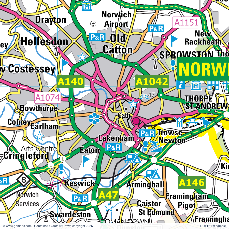
Explore the full 60 × 60 km Norwich regional road map at 1:250,000, covering Holt, Reepham, Dereham, Aylsham, Sheringham. Compare the complete coverage below; a detailed PDF sample is available free.

NORWICH & SURROUNDING AREAREGIONAL ROAD MAP
60 × 60 km · Full map previewDownload the free SVG ↓

INSIDE THE FULL 60 × 60 KM MAP

Explore the Norwich map area

1:250,000 cartography

Towns, villages & places

More mapped places (264)
  • Twyford
  • Foulsham
  • Bintree
  • Briston
  • Guestwick
  • Bale
  • Brinton
  • Hindringham
  • Gateley
  • Stody
  • Sharrington
  • Thurning
  • Thornage
  • Themelthorpe
  • Hunworth
  • Colkirk
  • Hempton
  • Foxley
  • Horningtoft
  • Binham
  • Billingford
  • Sculthorpe
  • Saxlingham
  • Brisley
  • Worthing
  • Oxwick
  • Westgate
  • Bawdeswell
  • Toftrees
  • Whissonsett
  • Letheringsett
  • Edgefield
  • Shereford
  • Langham
  • Wighton
  • Stanfield
  • Saxthorpe
  • Corpusty
  • Old Beetley
  • Salle
  • Heydon
  • East Bilney
  • Dunton
  • Cockthorpe
  • Glandford
  • Sparham
  • Whitwell
  • Hempstead
  • Warham
  • Waterden
  • Beetley
  • Hoe
  • Stiffkey
  • Mill Street
  • Booton
  • Tatterford
  • South Raynham
  • Morston
  • Oulton
  • Helhoughton
  • Mileham
  • Bittering
  • Gressenhall
  • Plumstead
  • Wiveton
  • High Kelling
  • Lyng
  • Blakeney
  • Elsing
  • Baconsthorpe
  • Woodgate
  • Tittleshall
  • Little Barningham
  • Itteringham
  • Cawston
  • Lenwade
  • South Creake
  • Wellingham
  • The Grove
  • Longham
  • Coxford
  • Salthouse
  • Matlaske
  • Brandiston
  • Kelling
  • Bodham
  • Eastgate
  • Weasenham St Peter
  • North Tuddenham
  • Litcham
  • Syderstone
  • North Creake
  • Alderford
  • Podmore
  • Weybourne
  • Swannington
  • East Rudham
  • Weasenham All Saints
  • Beeston
  • Holkham
  • Wickmere
  • Blickling
  • Bessingham
  • Morton
  • Gresham
  • Pockthorpe
  • West Rudham
  • Wendling
  • Hockering
  • Scarning
  • Attlebridge
  • Calthorpe
  • Aldborough
  • Barmer
  • Thurgarton
  • East Lexham
  • Erpingham
  • Ingworth
  • Rougham
  • Yaxham
  • Haveringland
  • Mattishall
  • Alby Hill
  • Sustead
  • West Lexham
  • Hanworth
  • The Heath
  • Marsham
  • Westfield
  • Felthorpe
  • Stanhoe
  • Bagthorpe
  • Whinburgh
  • Ringland
  • Welborne
  • Houghton
  • Honingham
  • Metton
  • Great Massingham
  • Little Massingham
  • Aylmerton
  • Harpley
  • Hevingham
  • Banningham
  • Colby
  • West Runton
  • Tuttington
  • Newton
  • Colton
  • Taverham
  • Felbrigg
  • Garvestone
  • Bradenham
  • Brampton
  • Ivy Todd
  • Thuxton
  • Shipdham
  • Roughton
  • Runhall
  • Suffield
  • Castle Acre
  • Bircham Newton
  • Easton
  • Necton
  • Horsford
  • Barnham Broom
  • Reymerston
  • Sporle
  • Buxton
  • Coston
  • Drayton
  • Docking
  • South Acre
  • Marlingford
  • Waterloo
  • Barford
  • Holme Hale
  • Felmingham
  • Costessey
  • Southburgh
  • Cranworth
  • Hainford
  • Skeyton
  • Antingham
  • Lamas
  • Anmer
  • Bawburgh
  • Northrepps
  • Southrepps
  • Wramplingham
  • Hardingham
  • Badersfield
  • West Acre
  • Brancaster
  • Fring
  • Kimberley
  • Woodrising
  • Bradfield
  • Overstrand
  • Flitcham
  • Frettenham
  • Titchwell
  • Westwick
  • Ashill
  • Sidestrand
  • Gayton Thorpe
  • Crownthorpe
  • Carbrooke
  • Hillington
  • Hackford
  • Wicklewood
  • Horstead
  • Ovington
  • Coltishall
  • Scottow
  • Shernborne
  • Swafield
  • Spixworth
  • Colney
  • East Walton
  • Grimston
  • Gimingham
  • Trunch
  • Scoulton
  • Crostwick
  • Sedgeford
  • Hethersett
  • Gayton
  • Trimingham
  • Sloley
  • Congham
  • Thornham
  • Deopham
  • Narborough
  • Roydon
  • Pott Row
  • Tunstead
  • Belaugh
  • Cringleford
  • Ketteringham
  • Ringstead
  • Pentney
  • West Bilney
  • Wroxham
  • Little Cressingham
  • Keswick
  • Cockley Cley
  • Thorpe End
  • Swardeston
  • Hilborough
  • Beachamwell
  • Mulbarton
  • Marham
  • Dunston
  • Arminghall
  • Swainsthorpe
  • Gooderstone
  • Postwick
  • Kirby Bedon
  • Barton Bendish
  • Oxborough
  • Bramerton
  • Poringland
  • Yelverton

Roads across this sheet

A11, A134, A140, A146, A147, A148, A149, A1024, A1042, A1054, A1056, A1065, A1067, A1074, A1075, A1082, A1122, A1151, A1242, A1402, B1077, B1105, B1108, B1110

More road numbers

B1113, B1135, B1140, B1145, B1146, B1147, B1149, B1150, B1153, B1155, B1156, B1172, B1332, B1354, B1355, B1436, B1439, B1440, B1454

Rivers & waterways

Babingley River, North Walsham & Dilham Canal (disused), River Bure, River Chet, River Glaven, River Nar, River Stiffkey, River Tud, River Wensum, River Wissey, River Yare

Landmarks & landscape

Adventure Activity Centre, Alby Craft Centre, Amazona Zoo, Anglican Shrine of Our Lady of Walsingham, Baconsthorpe Castle, Bailey Gate, Bailey Gate (Castle Acre), Binham Priory (remains of), Binham Wayside Cross, Bircham Windmill, Bishop Bonner's Cottage Museum, Gordon Boswell Romany Museum, Blakeney Guildhall, THE BROADS

More named features

Blakeney Nature Reserve, Blickling Hall, Blickling Hall Garden and Park, Bure Valley Railway, Buxton Heath Nature Reserve, Bygones Museum, Castle Acre, Castle Acre Priory (remains of), City of Norwich Aviation Museum, Cley Marshes Nature Reserve, Cley Marshes Visitor Centre, Cley Windmill, Cockley Cley Museum, Congham Hotel Gardens, County School Station, Cow Tower, Creake Abbey (remains of), Creake Abbey Studios, Cromer Museum, Cromer Lifeboat Museum, Davenport's Magic Kingdom, Dinosaur Adventure Park, Dragon Hall, Dragon Hall, Assembly House, Fakenham Racecourse, Fakenham Point to Point Racecourse, Farmland Bird Centre, Felbrigg Hall, Garden & Park, Flying Eight Balls Museum, Glandford Shell Museum, Cley Spy, Gooderstone Water Gardens, Great Walsingham Barns Craft Centre, Gressenhall Farm and Workhouse, Gunton Hall, Gunton Park Sawmill, Hall, Hawk & Owl Trust Visitor Centre, Henry Ramey Upcher Museum, Sheringham Lifeboat Museum, Hoe Rough Nature Reserve, Holkham Hall, Holt Country Park, Honeypot Wood Nature Reserve, Houghton Garden, Houghton Hall and Garden, Houghton House, Ice Experience, Kimberley House, Langham Glass, Letheringsett Watermill, Letton Hall, Litcham Common Nature Reserve, Little Cressingham Mill, Mannington Hall Gardens, Melsop Farm Park, Mid Norfolk Railway (Tourist Railway), Morston Marshes Nature Reserve, Museum Of Norfolk Rural Life, Norfolk Motor Cycle Museum, North Norfolk Railway, Norwich Arts Centre, Elm Hill, Pottergate Arts Centre, St Andrews Hall, Norwich Art Gallery, Norwich Cathedral, Oxborough Hall, Oxborough Wood Nature Reserve, Oxburgh Hall, Pensthorpe Natural Park, Picturecraft, Plantation Garden, Play Barn, Priory, Redwings Horse Sanctuary, Royal Norfolk Showground, Sainsbury Centre for Visual Arts, Saxon Cathedral (remains of), Shire Horse Centre, Shrine, Slipper Chapel, Solar Farm, Sparham Pools, Stanger's Hall Museum, Norwich Castle Museum, Royal Norfolk Regimental Museum, J Jarrold Printing Museum, Stody Lodge Gardens, Swaffham Museum, Swaffham Raceway, Swanton Novers Wood Nature Reserve, The Abbey, The Carmelite Friary at Burnham Norton, The Green Britain Centre, The Muckleburgh Collection, The Old Workshop Art Gallery, The Peter Coke Shell Gallery, The Shirehall Museum, The Straw Museum, The Thursford Collection, Titchwell Marsh Visitor Centre, Titchwell Nature Reserve, VENTA ICENORUM ROMAN TOWN, Venture Farm Animal Trust, Visitor Centre, Wells & Walsingham Light Railway, Wells Harbour Railway, West Acre Gardens, Weston Longville Solar Farm, Whitlingham Country Park, Whittingham Marsh Nature Reserve, Whitwell & Reepham Railway, Wicklewood Cornmill, Wildflower & Countryside Centre, William Marriott Museum at Holt Station, Winstanley Cats, Withers Gallery, Wolterton Hall, Wolterton Park, Wood Farm Visitor Centre Sheringham Park, Wymondham Abbey, Wymondham Heritage Museum
Local authority & parish coverage

Wholly or partly within the full map rectangle. These boundaries are coverage information, not additional artwork layers.

  • Breckland DistrictPartly within
  • Broadland DistrictPartly within
  • King's Lynn and West Norfolk DistrictPartly within
  • North Norfolk DistrictPartly within
  • Norwich DistrictPartly within
  • South Norfolk DistrictPartly within
Wards & electoral divisions 106 areas
  • Airfield Ward (part)
  • All Saints & Wayland Ward (part)
  • Ashill Ward (part)
  • Aylsham Ward
  • Bacton Ward (part)
  • Bedingfeld Ward (part)
  • Beeston Regis & The Runtons Ward
  • Bircham with Rudhams Ward
  • Bowthorpe Ward
  • Brancaster Ward (part)
  • Briston Ward
  • Brooke Ward (part)
  • Brundall Ward (part)
  • Burnham Market & Docking Ward
  • Buxton Ward
  • Catton Grove Ward
  • Central Wymondham Ward
  • Coastal Ward
  • Coltishall Ward
  • Cringleford Ward
  • Crome Ward
  • Cromer Town Ward
  • Dereham Neatherd Ward
  • Dereham Toftwood Ward
  • Dereham Withburga Ward
  • Dersingham Ward (part)
  • Drayton North Ward
  • Drayton South Ward
  • Easton Ward
  • Eaton Ward
  • Erpingham Ward
  • Eynesford Ward
  • Gayton & Grimston Ward (part)
  • Great Witchingham Ward
  • Gresham Ward
  • Heacham Ward (part)
  • Hellesdon North West Ward
  • Hellesdon South East Ward
  • Hermitage Ward
  • Hethersett Ward
  • Hevingham Ward
  • Hingham & Deopham Ward (part)
  • Holt Ward
  • Horsford and Felthorpe Ward
  • Hoveton & Tunstead Ward (part)
  • Lakenham Ward
  • Lancaster North Ward
  • Lancaster South Ward
  • Launditch Ward
  • Lincoln Ward
  • Mancroft Ward
  • Massingham with Castle Acre Ward (part)
  • Mattishall Ward
  • Mile Cross Ward
  • Mulbarton & Stoke Holy Cross Ward (part)
  • Mundesley Ward (part)
  • Nar Valley Ward
  • Necton Ward
  • Nelson Ward
  • New Costessey Ward
  • Newton Flotman Ward (part)
  • North Walsham East Ward (part)
  • North Walsham Market Cross Ward
  • North Walsham West Ward
  • North Wymondham Ward
  • Old Catton and Sprowston West Ward
  • Old Costessey Ward
  • Plumstead Ward (part)
  • Poppyland Ward
  • Poringland, Framinghams & Trowse Ward (part)
  • Priory Ward
  • Reepham Ward
  • Rockland Ward (part)
  • Roughton Ward (part)
  • Saham Toney Ward (part)
  • Sewell Ward
  • Sheringham North Ward
  • Sheringham South Ward
  • Shipdham-with-Scarning Ward
  • Snettisham Ward (part)
  • South Wymondham Ward (part)
  • Spixworth with St. Faiths Ward
  • Sprowston Central Ward
  • Sprowston East Ward
  • Stibbard Ward
  • Stody Ward
  • Suffield Park Ward
  • Swaffham Ward
  • Taverham North Ward
  • Taverham South Ward
  • The Raynhams Ward
  • Thorpe Hamlet Ward (part)
  • Thorpe St. Andrew North West Ward
  • Thorpe St. Andrew South East Ward
  • Town Close Ward
  • Trunch Ward (part)
  • University Ward
  • Upper Wensum Ward
  • Walsingham Ward
  • Watton Ward (part)
  • Wells with Holkham Ward
  • Wensum Ward
  • Wicklewood Ward (part)
  • Wissey Ward (part)
  • Worstead Ward (part)
  • Wroxham Ward (part)
Civil parishes & communities 324 areas
  • Alby with Thwaite CP
  • Aldborough & Thurgarton CP
  • Alderford CP
  • Alpington CP (part)
  • Anmer CP
  • Antingham CP
  • Ashill CP
  • Attlebridge CP
  • Aylmerton CP
  • Aylsham CP
  • Baconsthorpe CP
  • Bacton CP (part)
  • Bagthorpe with Barmer CP
  • Barford CP
  • Barnham Broom CP
  • Barsham CP
  • Barton Bendish CP
  • Barwick CP
  • Bawburgh CP
  • Bawdeswell CP
  • Beachamwell CP
  • Beeston Regis CP
  • Beeston St. Andrew CP
  • Beeston with Bittering CP
  • Beetley CP
  • Belaugh CP (part)
  • Bergh Apton CP (part)
  • Billingford CP
  • Binham CP
  • Bintree CP
  • Bircham CP
  • Blakeney CP
  • Blickling CP
  • Bodham CP
  • Booton CP
  • Boughton CP (part)
  • Bracon Ash CP (part)
  • Bradenham CP
  • Bramerton CP (part)
  • Brampton CP
  • Brancaster CP
  • Brandiston CP
  • Brandon Parva, Coston, Runhall and Welborne CP
  • Briningham CP
  • Brinton CP
  • Brisley CP
  • Briston CP
  • Brooke CP (part)
  • Burgh and Tuttington CP
  • Burnham Market CP
  • Burnham Norton CP
  • Burnham Overy CP
  • Burnham Thorpe CP
  • Buxton with Lammas CP
  • Bylaugh CP
  • Caistor St. Edmund and Bixley CP
  • Carbrooke CP (part)
  • Castle Acre CP
  • Cawston CP
  • Choseley CP
  • Cley Next the Sea CP
  • Cockley Cley CP
  • Colby CP
  • Colkirk CP
  • Colney CP
  • Coltishall CP
  • Congham CP (part)
  • Corpusty and Saxthorpe CP
  • Costessey CP
  • Cranworth CP
  • Cringleford CP
  • Cromer CP
  • Crostwick CP
  • Deopham CP (part)
  • Dereham CP
  • Dersingham CP (part)
  • Docking CP
  • Drayton CP
  • Dunton CP
  • East Beckham CP
  • East Carleton CP
  • East Rudham CP
  • East Tuddenham CP
  • East Walton CP
  • East Winch CP (part)
  • Easton CP
  • Edgefield CP
  • Elsing CP
  • Erpingham CP
  • Fakenham CP
  • Felbrigg CP
  • Felmingham CP
  • Felthorpe CP
  • Field Dalling CP
  • Fincham CP (part)
  • Flitcham with Appleton CP (part)
  • Foulden CP (part)
  • Foulsham CP
  • Foxley CP
  • Framingham Earl CP
  • Framingham Pigot CP
  • Fransham CP
  • Frettenham CP
  • Fring CP
  • Fulmodeston CP
  • Garvestone, Reymerston and Thuxton CP
  • Gateley CP
  • Gayton CP
  • Gimingham CP (part)
  • Gooderstone CP
  • Great Cressingham CP (part)
  • Great Dunham CP
  • Great Massingham CP
  • Great Melton CP
  • Great Snoring CP
  • Great Witchingham CP
  • Great and Little Plumstead CP (part)
  • Gresham CP
  • Gressenhall CP
  • Grimston CP (part)
  • Griston CP (part)
  • Guestwick CP
  • Guist CP
  • Gunthorpe CP
  • Hainford CP
  • Hanworth CP
  • Hardingham CP
  • Harpley CP
  • Haveringland CP
  • Heacham CP (part)
  • Helhoughton CP
  • Hellesdon CP
  • Hempstead CP
  • Hempton CP
  • Hethersett CP
  • Hevingham CP
  • Heydon CP
  • High Kelling CP
  • Hilborough CP (part)
  • Hillington CP (part)
  • Hindolveston CP
  • Hindringham CP
  • Hingham CP (part)
  • Hockering CP
  • Hoe and Worthing CP
  • Holkham CP
  • Holme Hale CP
  • Holme Next the Sea CP (part)
  • Holt CP
  • Holverston CP (part)
  • Honingham CP
  • Horningtoft CP
  • Horsford CP
  • Horsham St. Faith and Newton St. Faith CP
  • Horstead with Stanninghall CP
  • Houghton CP
  • Hoveton CP (part)
  • Howe CP (part)
  • Ingoldisthorpe CP (part)
  • Ingworth CP
  • Itteringham CP
  • Kelling CP
  • Kempstone CP
  • Keswick and Intwood CP
  • Ketteringham CP
  • Kettlestone CP
  • Kimberley and Carleton Forehoe CP
  • Kirby Bedon CP
  • Knapton CP (part)
  • Langham CP
  • Letheringsett with Glandford CP
  • Lexham CP
  • Leziate CP (part)
  • Litcham CP
  • Little Barningham CP
  • Little Cressingham CP (part)
  • Little Dunham CP
  • Little Ellingham CP (part)
  • Little Massingham CP
  • Little Melton CP
  • Little Snoring CP
  • Little Witchingham CP
  • Longham CP
  • Lyng CP
  • Marham CP (part)
  • Marlingford and Colton CP
  • Marsham CP
  • Matlask CP
  • Mattishall CP
  • Melton Constable CP
  • Merton CP (part)
  • Mileham CP
  • Morley CP (part)
  • Morston CP
  • Morton on the Hill CP
  • Mulbarton CP (part)
  • Mundesley CP (part)
  • Narborough CP
  • Narford CP
  • Necton CP
  • Newton By Castle Acre CP
  • Newton Flotman CP (part)
  • North Creake CP
  • North Elmham CP
  • North Pickenham CP
  • North Tuddenham CP
  • North Walsham CP (part)
  • Northrepps CP
  • Old Catton CP
  • Old Hunstanton CP (DET) (part)
  • Oulton CP
  • Overstrand CP
  • Ovington CP
  • Oxborough CP (part)
  • Paston CP (part)
  • Pentney CP (part)
  • Plumstead CP
  • Poringland CP (part)
  • Postwick with Witton CP (part)
  • Pudding Norton CP
  • Rackheath CP
  • Raynham CP
  • Reepham CP
  • Ringland CP
  • Ringstead CP (part)
  • Rougham CP
  • Roughton CP
  • Roydon CP (part)
  • Runton CP
  • Ryburgh CP
  • Saham Toney CP
  • Salhouse CP (part)
  • Salle CP
  • Salthouse CP
  • Sandringham CP (part)
  • Scarning CP
  • Scottow CP
  • Scoulton CP (part)
  • Sculthorpe CP
  • Sedgeford CP (part)
  • Sheringham CP
  • Shernborne CP
  • Shipdham CP
  • Shotesham CP (part)
  • Shouldham CP (part)
  • Sidestrand CP
  • Skeyton CP
  • Sloley CP (part)
  • Snettisham CP (part)
  • South Acre CP
  • South Creake CP
  • South Pickenham CP
  • Southrepps CP
  • Sparham CP
  • Spixworth CP
  • Spooner Row CP (part)
  • Sporle with Palgrave CP
  • Sprowston CP
  • Stanfield CP
  • Stanhoe CP
  • Stibbard CP
  • Stiffkey CP
  • Stody CP
  • Stoke Ferry CP (part)
  • Stoke Holy Cross CP
  • Stratton Strawless CP
  • Suffield CP
  • Surlingham CP (part)
  • Sustead CP
  • Swaffham CP
  • Swafield CP
  • Swainsthorpe CP (part)
  • Swannington CP
  • Swanton Abbott CP
  • Swanton Morley CP
  • Swanton Novers CP
  • Swardeston CP
  • Syderstone CP
  • Tattersett CP
  • Taverham CP
  • Themelthorpe CP
  • Thornage CP
  • Thornham CP
  • Thorpe Market CP
  • Thorpe St. Andrew CP
  • Thurning CP
  • Thursford CP
  • Titchwell CP
  • Tittleshall CP
  • Trimingham CP
  • Trowse with Newton CP
  • Trunch CP (part)
  • Tunstead CP (part)
  • Twyford CP
  • Upper Sheringham CP
  • Walsingham CP
  • Warham CP
  • Watton CP (part)
  • Weasenham All Saints CP
  • Weasenham St. Peter CP
  • Wellingham CP
  • Wells-Next-the-Sea CP
  • Wendling CP
  • West Acre CP
  • West Beckham CP
  • West Rudham CP
  • Weston Longville CP
  • Westwick CP
  • Weybourne CP
  • Whinburgh and Westfield CP
  • Whissonsett CP
  • Wicklewood CP (part)
  • Wickmere CP
  • Wighton CP
  • Wiveton CP
  • Wood Dalling CP
  • Wood Norton CP
  • Worstead CP (part)
  • Wramplingham CP
  • Wreningham CP (part)
  • Wroxham CP (part)
  • Wymondham CP (part)
  • Yaxham CP
  • Yelverton CP (part)

Source: the GBMaps road atlas, OS Boundary-Line and postcode mapping datasets. Source editions are being checked for publication. Unmarked boundary names are wholly within the sheet; “part” means the map edge crosses the area.

Place lists are selected from the map source, not a complete gazetteer. Named features describe the cartography; visitor facilities and opening status are not verified. The free sample covers only 12 × 12 km of this larger sheet.

INSIDE YOUR DOWNLOAD

A proper road map, in useful formats

Road classifications, towns and villages, railways, rivers, landscape detail and tourist symbols, brought together in the GBMaps regional road atlas style.

PDF filePDFSVG fileSVGAdobe Illustrator AI fileAi

PDF for the finished map. SVG and layered Illustrator artwork for adapting colours, adding your own information and preparing designs.

THE FINISHED SHEET

Designed for print and presentation

Map coverage
60 × 60 km
Sample coverage
12 × 12 km
Print layout
A3 landscape · enlarged 1:250k cartography
Sheet furniture
Border, scale bar, key & north arrow

A few useful details

What changes when I select another square?

Select a surrounding square to bring it into the centre and reveal the maps around it. Each square is a different 60 × 60 km map. The preview, free sample and selected download change together. Neighbouring sheets overlap by 30 km so you can choose the coverage that suits you.

Is the free sample a vector map?

The on-page detail is an SVG. The free download is a separate 12 × 12 km PDF with a link to the full map. Please retain its copyright credits and product link when sharing it.

Can I buy a larger combined map?

These downloads are individual ready-made sheets. Contact GBMaps if you need a larger combined area.

FREE PDF SAMPLE

Your free map sample

Your free 12 × 12 km sample includes a link back to this map, so you can return for the full area whenever you need it.

Download free PDF sample ↓

Get your Norwich map

Map download bundle

£24.00including VATOne payment

Pay securely

One payment. Your map stays open.

Your map download

Your map files

Preparing your download…

Checking your private download link…

Your map downloads

Already bought a map?

Find the downloads from your purchases.

Enter the email address you used at checkout. We’ll email you a private link to your available map downloads.