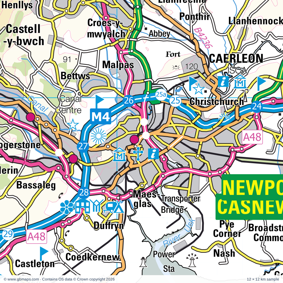
Newport regional road map. Full 60 × 60 km PDF, SVG and Illustrator files, with a free PDF sample.

GBMAPS.COM

Newport Regional Road Map

Call Us Now for Help01751 473136

GREAT BRITAIN ROAD ATLAS · 1:250,000 GB-330-0180

Newport & surrounding area

Explore the full 60 × 60 km Newport regional road map at 1:250,000, covering Risca, Clevedon, Penarth, Caerphilly, Abercarn. Compare the complete coverage below; a detailed PDF sample is available free.

NEWPORT & SURROUNDING AREAREGIONAL ROAD MAP
60 × 60 km · Full map previewDownload the free SVG ↓

INSIDE THE FULL 60 × 60 KM MAP

Explore the Newport map area

1:250,000 cartography

Towns, villages & places

More mapped places (259)

Roads across this sheet

M4, M5, M48, M49, A4, A37, A38, A39, A48, A48(M), A368, A369, A370, A371, A403, A420, A466, A467, A468, A469, A470, A472, A473, A3029

More road numbers

A3033, A4018, A4032, A4042, A4043, A4044, A4046, A4047, A4048, A4049, A4050, A4051, A4054, A4055, A4058, A4059, A4072, A4093, A4102, A4119, A4160, A4161, A4162, A4174, A4176, A4222, A4225, A4226, A4231, A4232, A4233, A4234, A4281, A4810, B3114, B3120, B3122, B3124, B3128, B3129, B3130, B3133, B3134, B3135, B3140, B3151, B3169, B3368, B3371, B3440, B4051, B4052, B4053, B4054, B4055, B4056, B4057, B4064, B4228, B4231, B4235, B4236, B4237, B4239, B4240, B4245, B4246, B4248, B4251, B4252, B4254, B4255, B4256, B4257, B4261, B4262, B4263, B4264, B4265, B4266, B4267, B4273, B4275, B4276, B4278, B4285, B4293, B4294, B4461, B4466, B4467, B4468, B4469, B4471, B4478, B4486, B4487, B4488, B4511, B4512, B4562, B4591, B4595, B4596, B4598, B4600, B4623

Rivers & waterways

Afon Cynon, Afon Ddawan / River Thaw, Afon Rhondda Fach, Ebbw River / Afon Ebwy, Ely River, Floating Harbour, Malpas Brook, Monmouthshire & Brecon Canal, Nant Olwy/ Olway Brook, Nant y Dderwen-deg / Roath Brook, Rhondda River / Afon Rhondda Fawr, Rhymney River / Afon Rhymni

More waterways

River Avon, River Axe, River Kenn, River Taff, River Usk / Afon Wsyg, River Wye, River Wye / Afon Gwy, River Yeo, Sirhowy River

Landmarks & landscape

Abbey Tintern Furnace, Alexander Gallery, Amelia Trust Farm, Animal Farm Adventure Park, At-Bristol,Mayflower & SS Great Britain Historic Ship, Avon Gorge National Nature Reserve, Axbridge Museum, Barry Island Pleasure Park, Barry Rail Centre, Barry Sidings Countryside Park-Heritage Park, Beaupre Castle, Big Pit National Museum of Mining (World Heritage Site), BRECON BEACONS NATIONAL PARK

More named features

Blaenavon Iron Works (World Heritage Site), Rhymney Brewery, Blaise Castle Estate, Blaise Castle Museum, Bleanavon Heritage & Cordell Museum, Blaenavon World Heritage Centre, Blue Reef Aquarium, Brean Down Fort, Brecon Mountain Railway, Bristol Cathedral, Clifton Cathedral, Bristol Zoo, Burrington Ham and Blackdown Common Nature Reserve, Caerleon Roman Fort, Caerphilly Castle, Caisson, Caldicot Castle & Museum, Caldicot Castle Country Park, Cardiff Castle, Castell Coch, Cefn Mably Farm Park, Chapter Arts Centre, Llanover Hall Arts Centre, Chepstow Castle, Chepstow Museum, Chepstow Racecourse, Clevedon Court, Clevedon Craft Centre, Clifton Suspension Bridge, SS Great Britain, Cosmeston Lakes Country Park, Cosmeston Medieval Village, Court Farm Park, Crook Peak and Wavering Down Nature Reserve, Crystal Quest, Cyfartha Museum & Art Gallery, Ynysfach Iron Heritage Centre, Joseph Parry's Cottage, Dewstow Gardens, Doctor Who Experience, Dolebury Warren Nature Reserve, Dyffryn Gardens, Elliot's Colliery Winding House Museum, Fforest Uchaf Horse or Pony Centre, Five Locks Canal Nature Reserve, Flat Holm Nature Reserve, Fonmon Castle, Fourteen Locks Canal Centre, Goytre Wharf, Grand Pier, Greenmeadow Community Farm, Gwent Rural Life Museum, Hartcliffe Community Park Farm, International Helicopter Museum, International Sports Venue, Canoeing & Rafting, Kingsweston Down Nature Reserve, Lancaiach Fawr, Langstone Solar Farm, Llandaff Cathedral, Cardiff Cathedral, Llandegfedd Visitor Centre, Llanerch Vineyard, Llanmelin Wood Hillforts, Llantarnam Abbey, Long Cairn, Makers Guild in Wales-Craft in the Bay, Model House Craft and Design Centre, Museum, Nantgarw China Works, National Indoor Athletics Centre, National Museum & Gallery, Welch Regiment Museum, Butetown History and Arts Centre, Newport Museum & Art Gallery, Noah's Ark Zoo Farm, North Somerset Museum, Oakham Treasures Museum, Offa's Dyke, Parc Cefn Onn Country Park, Parc Cwm Darran Country Park, Parc Cwm Darren, Parc Penalta Country Park, Pen-y-fan Pond Country Park, Perrygrove Miniature Railway, Pontypool & Blaenavon Railway, Pontypool Museum, Pontypridd Museum, Porthkerry Country Park, Puxton Park, Puzzle Wood, Raglan Castle, Rhondda Heritage Park, Roman Amphitheatre, Roman Baths Museum, Roman Legionary Museum, Runstan Chapel (remains of), Ruperra Castle, Sand Point and Middle Hope Nature Reserve, Sirhowy Valley Country Park, Six Bells Mining Monument, St Briavels Castle, St Fagans National History Museum, St Lythans Burial Chamber, St Woolos Cathedral, Techniquest, The Assembly at the Pierhead, Norwegian Church Arts Centre,Dr Who Experience, Motorpoint Arena, Temple Church, The Cheddar Gorge Cheese Company, The Ebbw Vale Works Museum, Tinkinswood Burial Chamber, Tintern Abbey, Tredegar House, Tredegar House Country Park, Tredegar House Gardens, Tropical Bird Garden, Turner House Gallery, Tyntesfield, Usk Castle, Veddw House Garden, Venta Silvrvm Roman Town, Visitor Centre, Warren Mill Farm Park, Welsh Hawking Centre, Weston-Super-Mare Sea Aquarium, Wild Place Project, Windmill Hill City Farm, Woodspring Priory
Local authority & parish coverage

Wholly or partly within the full map rectangle. These boundaries are coverage information, not additional artwork layers.

  • Bath and North East SomersetPartly within
  • Blaenau Gwent - Blaenau GwentPartly within
  • Bro Morgannwg - the Vale of GlamorganPartly within
  • Caerdydd - CardiffWholly within
  • Caerffili - CaerphillyPartly within
  • Casnewydd - NewportWholly within
  • City of BristolPartly within
  • Forest of Dean DistrictPartly within
  • Merthyr Tudful - Merthyr TydfilPartly within
  • North SomersetWholly within
  • Rhondda Cynon Taf - Rhondda Cynon TafPartly within
  • Sir Fynwy - MonmouthshirePartly within
  • SomersetPartly within
  • South GloucestershirePartly within
  • Torfaen - TorfaenPartly within
Wards & electoral divisions 285 areas
  • Ashley Ward (part)
  • Avonmouth & Lawrence Weston Ward
  • Backwell Ward
  • Banwell & Winscombe Ward
  • Bedminster Ward
  • Bishopston & Ashley Down Ward (part)
  • Bishopsworth Ward
  • Blagdon & Churchill Ward
  • Bream Ward (part)
  • Central Ward
  • Charlton & Cribbs Ward (part)
  • Chew Valley Ward (part)
  • Clevedon East Ward
  • Clevedon South Ward
  • Clevedon Walton Ward
  • Clevedon West Ward
  • Clevedon Yeo Ward
  • Clifton Down Ward
  • Clifton Ward
  • Coleford Ward (part)
  • Congresbury & Puxton Ward
  • Cotham Ward
  • Filton Ward (part)
  • Filwood Ward (part)
  • Gordano Valley Ward
  • Hartcliffe & Withywood Ward
  • Henbury & Brentry Ward
  • Hengrove & Whitchurch Park Ward (part)
  • Horfield Ward (part)
  • Hotwells & Harbourside Ward
  • Hutton & Locking Ward
  • Knowle Ward (part)
  • Lawrence Hill Ward (part)
  • Lockleaze Ward (part)
  • Long Ashton Ward
  • Lydney West & Aylburton Ward (part)
  • Mendip Ward (part)
  • Nailsea Golden Valley Ward
  • Nailsea West End Ward
  • Nailsea Yeo Ward
  • Nailsea Youngwood Ward
  • Newland & Sling Ward (part)
  • Patchway Coniston Ward (part)
  • Pill Ward
  • Pilning & Severn Beach Ward
  • Portishead East Ward
  • Portishead North Ward
  • Portishead South Ward
  • Portishead West Ward
  • Publow & Whitchurch Ward (part)
  • Redland Ward
  • Severn Vale Ward (part)
  • Southmead Ward
  • Southville Ward
  • St. Briavels Ward (part)
  • Stoke Bishop Ward
  • Tidenham Ward (part)
  • Westbury-on-Trym & Henleaze Ward
  • Weston-super-Mare Central Ward
  • Weston-super-Mare Hillside Ward
  • Weston-super-Mare Kewstoke Ward
  • Weston-super-Mare Mid Worle Ward
  • Weston-super-Mare Milton Ward
  • Weston-super-Mare North Worle Ward
  • Weston-super-Mare South Ward
  • Weston-super-Mare South Worle Ward
  • Weston-super-Mare Uphill Ward
  • Weston-super-Mare Winterstoke Ward
  • Wick St. Lawrence & St. Georges Ward
  • Windmill Hill Ward (part)
  • Winford Ward
  • Wrington Ward
  • Yatton Ward
  • Aber Valley ED
  • Aberaman ED (part)
  • Aberbargoed and Bargoed ED
  • Abercarn ED
  • Abercynon ED
  • Aberdare East ED (part)
  • Aberdare West and Llwydcoed ED (part)
  • Abersychan ED
  • Abertillery and Six Bells ED
  • Adamsdown ED
  • Allt-yr-yn ED
  • Alway ED
  • Argoed ED
  • Baruc ED
  • Beddau and Tyn-y-nant ED
  • Bedlinog and Trelewis ED
  • Bedwas and Trethomas ED
  • Beechwood ED
  • Bettws ED
  • Bishton and Langstone ED
  • Blackwood ED
  • Blaenavon ED (part)
  • Blaina ED (part)
  • Brent ED (part)
  • Brynna and Llanharan ED (part)
  • Bulwark and Thornwell ED
  • Burnham on Sea North ED (part)
  • Butetown ED
  • Buttrills ED
  • Cadoc ED
  • Caerau ED
  • Caerleon ED
  • Caerwent ED
  • Caldicot Castle ED
  • Caldicot Cross ED
  • Cannington ED (part)
  • Canton ED
  • Castleland ED
  • Cathays ED
  • Cefn Fforest and Pengam ED
  • Cheddar ED (part)
  • Chepstow Castle and Larkfield ED
  • Church Village ED
  • Cilfynydd ED
  • Coed Eva ED
  • Cornerswell ED
  • Court ED
  • Cowbridge ED (part)
  • Croesyceiliog ED
  • Crosskeys ED
  • Crumlin ED
  • Cwm ED
  • Cwmbach ED
  • Cwmtillery ED
  • Cyfarthfa ED (part)
  • Cymer ED
  • Cyncoed ED
  • Darran Valley ED
  • Devauden ED
  • Dewstow ED
  • Dinas Powys ED
  • Dowlais and Pant ED (part)
  • Dyfan ED
  • Ebbw Vale North ED (part)
  • Ebbw Vale South ED
  • Ely ED
  • Fairwater ED
  • Fairwater ED
  • Ferndale and Maerdy ED (part)
  • Gabalfa ED
  • Gaer ED
  • Georgetown ED
  • Gibbonsdown ED
  • Gilfach ED
  • Glyn-coch ED
  • Gobion Fawr ED (part)
  • Goetre Fawr ED (part)
  • Graig ED
  • Graig and Pontypridd West ED
  • Grangetown ED
  • Greenmeadow ED
  • Gurnos ED
  • Hawthorn and Lower Rhydfelen ED
  • Heath ED
  • Hengoed ED
  • Hirwaun, Penderyn and Rhigos ED (part)
  • Illtyd ED
  • King Alfred ED (part)
  • Lisvane and Thornhill ED
  • Llanbadoc and Usk ED
  • Llanbradach ED
  • Llandaff ED
  • Llandaff North ED
  • Llandough ED
  • Llanfoist Fawr and Govilon ED (part)
  • Llanfrechfa and Ponthir ED
  • Llangybi Fawr ED
  • Llanharry ED (part)
  • Llanhilleth ED
  • Llanishen ED
  • Llanrumney ED
  • Llantarnam ED
  • Llantrisant and Talbot Green ED
  • Llantwit Fardre ED
  • Llantwit Major ED (part)
  • Llanwern ED
  • Llanyrafon ED
  • Lliswerry ED
  • Llwyn-y-pia ED (part)
  • Machen and Rudry ED
  • Maesycwmmer ED
  • Magor East with Undy ED
  • Magor West ED
  • Malpas ED
  • Mendip Hills ED (part)
  • Mendip West ED (part)
  • Merthyr Vale ED
  • Mitchel Troy and Trellech United ED (part)
  • Morgan Jones ED
  • Moriah and Pontlottyn ED
  • Mount Pleasant ED
  • Mountain Ash ED
  • Nantyglo ED (part)
  • Nelson ED
  • New Inn ED
  • New Tredegar ED
  • Newbridge ED
  • Panteg ED
  • Park ED
  • Pen-y-graig ED (part)
  • Penmaen ED
  • Penrhiw-ceibr ED
  • Pentwyn ED
  • Pentyrch and St. Fagans ED
  • Penydarren ED
  • Penylan ED
  • Penyrheol ED
  • Peterston-super-Ely ED
  • Pillgwenlly ED
  • Plasnewydd ED
  • Plymouth ED
  • Plymouth ED
  • Pontllanfraith ED
  • Pontnewydd ED
  • Pontnewynydd and Snatchwood ED
  • Pontprennau and Old St. Mellons ED
  • Pontyclun Central ED
  • Pontyclun East ED
  • Pontyclun West ED
  • Pontypool Fawr ED
  • Pontypridd Town ED
  • Porth ED
  • Portskewett ED
  • Radyr ED
  • Raglan ED
  • Rhiwbina ED
  • Rhoose ED
  • Rhydfelen Central ED
  • Ringland ED
  • Risca East ED
  • Risca West ED
  • Riverside ED
  • Rogerstone East ED
  • Rogerstone North ED
  • Rogerstone West ED
  • Rogiet ED
  • Rumney ED
  • Severn ED
  • Shaftesbury ED
  • Shirenewton ED
  • Sirhowy ED (part)
  • Splott ED
  • St. Arvans ED
  • St. Athan ED (part)
  • St. Augustine's ED
  • St. Cattwg ED
  • St. Dials ED
  • St. Julians ED
  • St. Kingsmark ED
  • St. Martins ED
  • St. Nicholas and Llancarfan ED
  • Stanwell ED
  • Stow Hill ED
  • Sully ED
  • Taff's Well ED
  • Ton-teg ED
  • Tonyrefail East ED
  • Tonyrefail West ED (part)
  • Town ED
  • Trallwng ED
  • Trealaw ED (part)
  • Tredegar ED (part)
  • Tredegar Park and Marshfield ED
  • Treforest ED
  • Treharris ED
  • Trevethin and Penygarn ED
  • Trowbridge ED
  • Two Locks ED
  • Twyn Carno ED (part)
  • Tylorstown and Ynyshir ED (part)
  • Upper Cwmbran ED
  • Upper Rhydfelen and Glyn-taf ED
  • Van ED
  • Vaynor ED (part)
  • Victoria ED
  • Wenvoe ED
  • West End ED
  • Whitchurch and Tongwynlais ED
  • Ynysddu ED
  • Ynysybwl ED
  • Ystrad ED (part)
  • Ystrad Mynach ED
Civil parishes & communities 292 areas
  • Abbots Leigh CP
  • Aber Valley Community
  • Aberaman North Community (part)
  • Aberaman South Community (part)
  • Abercarn Community
  • Abercynon Community
  • Aberdare East Community (part)
  • Aberdare West Community (part)
  • Abersychan Community
  • Abertillery Community
  • Adamsdown Community
  • Allt-yr-Yn Community
  • Almondsbury CP (part)
  • Alvington CP (part)
  • Alway Community
  • Argoed Community
  • Aust CP (part)
  • Axbridge CP
  • Aylburton CP (part)
  • Backwell CP
  • Badgworth CP (part)
  • Banwell CP
  • Bargoed Community
  • Barrow Gurney CP
  • Barry Community
  • Bedlinog Community
  • Bedwas, Trethomas and Machen Community
  • Beechwood Community
  • Berrow CP
  • Bettws Community
  • Bishton Community
  • Blackwood Community
  • Blaenavon Community (part)
  • Blagdon CP
  • Bleadon CP
  • Brean CP
  • Brent Knoll CP (part)
  • Brockley CP
  • Burnham Without CP (part)
  • Burnham-on-Sea and Highbridge CP (part)
  • Burrington CP
  • Butcombe CP
  • Butetown Community
  • Caerau Community
  • Caerleon Community
  • Caerphilly Community
  • Caerwent Community
  • Caldicot Community
  • Canton Community
  • Castle Community
  • Cathays Community
  • Cefn Fforest Community
  • Chapel Allerton CP (part)
  • Charlton Hayes CP (part)
  • Cheddar CP (part)
  • Chepstow Community
  • Chew Magna CP (part)
  • Chew Stoke CP
  • Chewton Mendip CP (part)
  • Churchill CP
  • Clapton-in-Gordano CP
  • Cleeve CP
  • Clevedon CP
  • Coedkernew Community
  • Coleford CP (part)
  • Compton Bishop CP
  • Compton Martin CP
  • Congresbury CP
  • Cowbridge with Llanblethian Community (part)
  • Croesyceiliog Community
  • Crosskeys Community
  • Crumlin Community
  • Cwm Community
  • Cwmbach Community
  • Cwmbran Central Community
  • Cyfarthfa Community (part)
  • Cymmer Community
  • Cyncoed Community
  • Darran Valley Community
  • Devauden Community
  • Dinas Powys Community
  • Dowlais Community
  • Dundry CP
  • East Brent CP (part)
  • East Harptree CP
  • Ebbw Vale North Community (part)
  • Ebbw Vale South Community
  • Ely Community
  • Emborough CP (part)
  • Fairwater Community
  • Fairwater Community
  • Ferndale Community (part)
  • Filton CP (part)
  • Flax Bourton CP
  • Gabalfa Community
  • Gaer Community
  • Gelligaer Community
  • Gobion Fawr Community (part)
  • Goetre Fawr Community (part)
  • Goldcliff Community
  • Graig Community
  • Grangetown Community
  • Gurnos Community
  • Heath Community
  • Henllys Community
  • Hewelsfield and Brockweir CP
  • Hinton Blewett CP (part)
  • Hirwaun Community (part)
  • Hutton CP
  • Kenn CP
  • Kewstoke CP
  • Kingston Seymour CP
  • Langstone Community
  • Lisvane Community
  • Liswerry Community
  • Litton CP (part)
  • Llanarth Community (part)
  • Llanbadoc Community
  • Llanbradach and Pwllypant Community
  • Llancarfan Community
  • Llandaff Community
  • Llandaff North Community
  • Llandough Community
  • Llanedeyrn Community
  • Llanfair Community (part)
  • Llanfoist Fawr Community (part)
  • Llangybi Community
  • Llanharan Community (part)
  • Llanharry Community (part)
  • Llanhilleth Community
  • Llanishen Community
  • Llanmaes Community (part)
  • Llanrumney Community
  • Llantarnam Community
  • Llantrisant Community
  • Llantrisant Fawr Community
  • Llantwit Fardre Community
  • Llantwit Major Community (part)
  • Llanvaches Community
  • Llanwern Community
  • Llanyrafon Community
  • Llwydcoed Community (part)
  • Llwyn-y-pia Community (part)
  • Locking CP
  • Long Ashton CP
  • Loxton CP
  • Lympsham CP
  • Maesycwmmer Community
  • Magor with Undy Community
  • Malpas Community
  • Mark CP (part)
  • Marshfield Community
  • Mathern Community
  • Merthyr Vale Community
  • Michaelston-le-Pit and Leckwith Community
  • Michaelstone-y-Fedw Community
  • Mitchel Troy Community (part)
  • Mountain Ash East Community
  • Mountain Ash West Community
  • Nailsea CP
  • Nantyglo and Blaina Community (part)
  • Nash Community
  • Nelson Community
  • Nempnett Thrubwell CP
  • New Inn Community
  • New Tredegar Community
  • Newbridge Community
  • Newland CP (part)
  • Norton Malreward CP (part)
  • Old St. Mellons Community
  • Oldbury-upon-Severn CP (part)
  • Olveston CP (part)
  • Otterhampton CP (part)
  • Pant Community (part)
  • Panteg Community
  • Park Community
  • Patchway CP (part)
  • Pen Tranch Community
  • Pen-y-graig Community (part)
  • Penarth Community
  • Pendoylan Community
  • Pengam Community
  • Penhow Community
  • Penllyn Community (part)
  • Penmaen Community
  • Penrhiw-ceiber Community
  • Pentwyn Community
  • Pentyrch Community
  • Penydarren Community
  • Penylan Community
  • Penyrheol, Trecenydd and Energlyn Community
  • Peterston-super-Ely Community
  • Pill and Easton-in-Gordano CP
  • Pillgwenlly Community
  • Pilning and Severn Beach CP
  • Pont-y-clun Community
  • Pontcanna Community
  • Ponthir Community
  • Pontllanfraith Community
  • Pontnewydd Community
  • Pontprennau Community
  • Pontymoile Community
  • Pontypridd Town Community
  • Portbury CP
  • Porth Community
  • Portishead CP
  • Portskewett Community
  • Priddy CP (part)
  • Puxton CP
  • Radyr and Morganstown Community
  • Raglan Community
  • Redwick Community
  • Rhiwbina Community
  • Rhoose Community
  • Rhymney Community (part)
  • Ringland Community
  • Risca East Community
  • Risca West Community
  • Riverside Community
  • Roath Community
  • Rodney Stoke CP (part)
  • Rogerstone Community
  • Rogiet Community
  • Rudry Community
  • Rumney Community
  • Shaftesbury Community
  • Shipham CP
  • Shirenewton Community
  • Splott Community
  • St. Arvans Community
  • St. Athan Community (part)
  • St. Briavels CP
  • St. Cuthbert Out CP (part)
  • St. Fagans Community
  • St. Georges CP
  • St. Georges-super-Ely Community
  • St. Julians Community
  • St. Nicholas and Bonvilston Community
  • Stanton Drew CP (part)
  • Stow Hill Community
  • Stowey-Sutton CP (part)
  • Sully and Lavernock Community
  • Taffs Well Community
  • Temple Cloud with Cameley CP (part)
  • Thornhill Community
  • Tickenham CP
  • Tidenham CP
  • Tongwynlais Community
  • Tonyrefail Community (part)
  • Town Community
  • Trealaw Community (part)
  • Tredegar Community (part)
  • Tredegar Park Community
  • Trehafod Community
  • Treharris Community
  • Trellech United Community (part)
  • Tremorfa Community
  • Trevethin Community
  • Troed-y-rhiw Community
  • Trowbridge Community
  • Tylorstown Community (part)
  • Ubley CP
  • Upper Cwmbran Community
  • Usk Community
  • Van Community
  • Vaynor Community (part)
  • Victoria Community
  • Walton-in-Gordano CP
  • Weare CP
  • Wedmore CP (part)
  • Welsh St. Donats Community
  • Wentlooge Community
  • Wenvoe Community
  • West Dean CP (part)
  • West Harptree CP
  • Westbury CP (part)
  • Weston-Super-Mare CP
  • Weston-in-Gordano CP
  • Whitchurch CP (part)
  • Whitchurch Community
  • Wick St. Lawrence CP
  • Winford CP
  • Winscombe and Sandford CP
  • Woolaston CP (part)
  • Wraxall and Failand CP
  • Wrington CP
  • Wye Valley Community
  • Yatton CP
  • Ynysddu Community
  • Ynyshir Community
  • Ynysybwl and Coed-y-Cwm Community
  • Ystrad Community (part)

Source: the GBMaps road atlas, OS Boundary-Line and postcode mapping datasets. Source editions are being checked for publication. Unmarked boundary names are wholly within the sheet; “part” means the map edge crosses the area.

Place lists are selected from the map source, not a complete gazetteer. Named features describe the cartography; visitor facilities and opening status are not verified. The free sample covers only 12 × 12 km of this larger sheet.

INSIDE YOUR DOWNLOAD

A proper road map, in useful formats

Road classifications, towns and villages, railways, rivers, landscape detail and tourist symbols, brought together in the GBMaps regional road atlas style.

PDF filePDFSVG fileSVGAdobe Illustrator AI fileAi

PDF for the finished map. SVG and layered Illustrator artwork for adapting colours, adding your own information and preparing designs.

THE FINISHED SHEET

Designed for print and presentation

Map coverage
60 × 60 km
Sample coverage
12 × 12 km
Print layout
A3 landscape · enlarged 1:250k cartography
Sheet furniture
Border, scale bar, key & north arrow

A few useful details

What changes when I select another square?

Select a surrounding square to bring it into the centre and reveal the maps around it. Each square is a different 60 × 60 km map. The preview, free sample and selected download change together. Neighbouring sheets overlap by 30 km so you can choose the coverage that suits you.

Is the free sample a vector map?

The on-page detail is an SVG. The free download is a separate 12 × 12 km PDF with a link to the full map. Please retain its copyright credits and product link when sharing it.

Can I buy a larger combined map?

These downloads are individual ready-made sheets. Contact GBMaps if you need a larger combined area.

FREE PDF SAMPLE

Your free map sample

Your free 12 × 12 km sample includes a link back to this map, so you can return for the full area whenever you need it.

Download free PDF sample ↓

Get your Newport map

Map download bundle

£24.00including VATOne payment

Pay securely

One payment. Your map stays open.

Your map download

Your map files

Preparing your download…

Checking your private download link…

Your map downloads

Already bought a map?

Find the downloads from your purchases.

Enter the email address you used at checkout. We’ll email you a private link to your available map downloads.