Newport regional road map. Full 60 × 60 km PDF, SVG and Illustrator files, with a free PDF sample.

GBMAPS.COM

Newport Regional Road Map

Call Us Now for Help01751 473136

GREAT BRITAIN ROAD ATLAS · 1:250,000 GB-330-0210

Newport & surrounding area

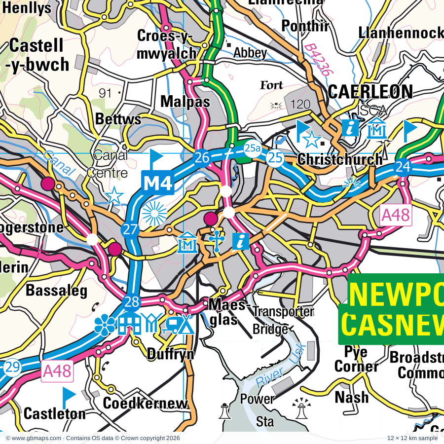
Explore the full 60 × 60 km Newport regional road map at 1:250,000, covering Hereford, Y Fenni, Blaenavon, Abersychan, Pontypool. Compare the complete coverage below; a detailed PDF sample is available free.

NEWPORT & SURROUNDING AREAREGIONAL ROAD MAP
60 × 60 km · Full map previewDownload the free SVG ↓

INSIDE THE FULL 60 × 60 KM MAP

Explore the Newport map area

1:250,000 cartography

Towns, villages & places

More mapped places (325)

Roads across this sheet

M4, M5, M48, M49, A48, A48(M), A403, A438, A465, A466, A467, A468, A469, A470, A472, A473, A4018, A4042, A4043, A4046, A4047, A4048, A4049, A4051

More road numbers

A4054, A4058, A4059, A4072, A4077, A4078, A4079, A4093, A4102, A4119, A4136, A4137, A4143, A4222, A4225, A4232, A4233, A4281, A4810, B4028, B4055, B4064, B4146, B4224, B4226, B4228, B4231, B4233, B4234, B4235, B4236, B4237, B4239, B4240, B4245, B4246, B4248, B4251, B4252, B4254, B4255, B4256, B4257, B4260, B4262, B4263, B4264, B4269, B4273, B4275, B4276, B4278, B4285, B4293, B4299, B4347, B4348, B4349, B4350, B4352, B4399, B4432, B4461, B4471, B4478, B4486, B4487, B4511, B4512, B4520, B4521, B4560, B4562, B4591, B4595, B4596, B4598, B4600, B4601, B4602, B4623, B5448

Rivers & waterways

Afon Cynon, Afon Honddu, Afon Llynfi / Llynfi River, Afon Mynwy / River Monnow, Afon Rhondda Fach, Afon Troddu / River Trothy, Afon Ysgir, Ebbw River / Afon Ebwy, Ely River, Grwyne Fawr, Grwyne Fechan, Honddu

More waterways

Malpas Brook, Monmouthshire & Brecon Canal, Nant Olwy/ Olway Brook, Rhondda River / Afon Rhondda Fawr, Rhymney River / Afon Rhymni, River Dore, River Frome, River Lugg, River Taff, River Usk / Afon Wsyg, River Wye, River Wye / Afon Gwy, Sirhowy River, Taf Fechan

Landmarks & landscape

Abbey Dore, Abbey Dore Court Gardens, Abbey Tintern Furnace, Abergavenny Castle, Abergavenny Museum, Activity Centre, Aneurin Bevan Commemorative Stones, Barry Sidings Countryside Park-Heritage Park, Belmont Abbey, Big Pit National Museum of Mining (World Heritage Site), Bird Attraction, Blaenavon Iron Works (World Heritage Site), Rhymney Brewery, BRECON BEACONS NATIONAL PARK

More named features

Bleanavon Heritage & Cordell Museum, Blaenavon World Heritage Centre, Boughrood Motte, Brecon Cathedral, Brecon Gaer Fort, Brecon Mountain Railway, Bronllys Castle Keep, Broome Farm, CICVCIVM, Caerleon Roman Fort, Caerphilly Castle, Caldicot Castle & Museum, Caldicot Castle Country Park, Cantref Adventure Farm, Castell Coch, Cefn Mably Farm Park, Chepstow Castle, Chepstow Museum, Chepstow Racecourse, Clydach Ironworks, Cyfartha Museum & Art Gallery, Ynysfach Iron Heritage Centre, Joseph Parry's Cottage, Dewsall Court, Dewstow Gardens, Dovecote, Elliot's Colliery Winding House Museum, Fforest Uchaf Horse or Pony Centre, Five Locks Canal Nature Reserve, Fourteen Locks Canal Centre, GWR Museum, Garwnant Vistor Centre, Goodrich Castle, Goodrich Castle Visitor Centre, Goytre Wharf, Greenmeadow Community Farm, Grosmont Castle, Gwent Rural Life Museum, Hen Gwrt Moated Site, Howell Harris Museum, Kentchurch Court, Lancaiach Fawr, Langstone Court, Langstone Solar Farm, Llandegfedd Visitor Centre, Llangorse Multi Activity Centre, Llanmelin Wood Hillforts, Llantarnam Abbey, Llanthony Priory, Llanvihangel Court, Longtown Castle, Malthouse Museum & Art Gallery, Model House Craft and Design Centre, Monmouth Castle, Monnow Valley Arts, Museum, Nantgarw China Works, Naval Temple, Nelson Museum & Local History Centre, Regimental Museum, Newport Museum & Art Gallery, Offa's Dyke, Old House Museum, St John Mediaeval Museum, City Museum, Cider Museum, Parc Brynbach, Parc Cefn Onn Country Park, Parc Cwm Darran Country Park, Parc Cwm Darren, Parc Penalta Country Park, Pen-y-fan Pond Country Park, Penpergwm Lodge, Penyclawdd Court, Perrygrove Miniature Railway, Pontypool & Blaenavon Railway, Pontypool Museum, Pontypridd Museum, Puzzle Wood, Pwll-Y-Wrach Nature Reserve, Raglan Castle, Regimental Museum, County Record Office, Castle Green, Rhondda Heritage Park, Roman Amphitheatre, Roman Baths Museum, Roman Legionary Museum, Rotherwas Chapel, Runstan Chapel (remains of), Ruperra Castle, Shipley Gardens, Sirhowy Valley Country Park, Six Bells Mining Monument, Skenfrith Castle, South Wales Borders Museum, St Briavels Castle, St Woolos Cathedral, Strawberry Cottage Wood Reserve, Sugarloaf Vineyard, The Amazing Hedge Puzzle, Wye Valley Butterfly Zoo, Wye Valley Visitor Centre, The Ebbw Vale Works Museum, The Punchbowl Nature Reserve, The Violette Szabo Museum, Tintern Abbey, Tredegar House, Tredegar House Country Park, Tredegar House Gardens, Tretower Court and Castle, Usk Castle, Veddw House Garden, Venta Silvrvm Roman Town, Visitor Centre, Waterworks Museum, White Castle, Wild Place Project
Local authority & parish coverage

Wholly or partly within the full map rectangle. These boundaries are coverage information, not additional artwork layers.

  • Blaenau Gwent - Blaenau GwentWholly within
  • Bro Morgannwg - the Vale of GlamorganPartly within
  • Caerdydd - CardiffPartly within
  • Caerffili - CaerphillyWholly within
  • Casnewydd - NewportPartly within
  • City of BristolPartly within
  • County of HerefordshirePartly within
  • Forest of Dean DistrictPartly within
  • Merthyr Tudful - Merthyr TydfilPartly within
  • Powys - PowysPartly within
  • Rhondda Cynon Taf - Rhondda Cynon TafPartly within
  • Sir Fynwy - MonmouthshireWholly within
  • South GloucestershirePartly within
  • Torfaen - TorfaenWholly within
Wards & electoral divisions 238 areas
  • Avonmouth & Lawrence Weston Ward (part)
  • Aylestone Hill Ward (part)
  • Backbury Ward (part)
  • Belmont Rural Ward
  • Berry Hill Ward (part)
  • Birch Ward
  • Bream Ward (part)
  • Central Ward (part)
  • Charlton & Cribbs Ward (part)
  • Coleford Ward
  • Credenhill Ward (part)
  • Dinedor Hill Ward
  • Eign Hill Ward (part)
  • Filton Ward (part)
  • Golden Valley North Ward (part)
  • Golden Valley South Ward
  • Greyfriars Ward (part)
  • Hagley Ward (part)
  • Hinton & Hunderton Ward
  • Kerne Bridge Ward (part)
  • Llangarron Ward
  • Lydbrook Ward (part)
  • Lydney West & Aylburton Ward (part)
  • Mitcheldean, Ruardean & Drybrook Ward (part)
  • Newland & Sling Ward
  • Newton Farm Ward
  • Old Gore Ward (part)
  • Patchway Coniston Ward (part)
  • Pilning & Severn Beach Ward (part)
  • Red Hill Ward
  • Ross East Ward (part)
  • Ross North Ward (part)
  • Ross West Ward (part)
  • Saxon Gate Ward
  • Severn Vale Ward (part)
  • St. Briavels Ward (part)
  • Stoney Street Ward (part)
  • Tidenham Ward (part)
  • Tupsley Ward (part)
  • Wormside Ward
  • Aber Valley ED
  • Aberaman ED (part)
  • Aberbargoed and Bargoed ED
  • Abercarn ED
  • Abercynon ED
  • Aberdare East ED (part)
  • Aberdare West and Llwydcoed ED (part)
  • Abersychan ED
  • Abertillery and Six Bells ED
  • Allt-yr-yn ED
  • Alway ED
  • Argoed ED
  • Beaufort ED
  • Beddau and Tyn-y-nant ED
  • Bedlinog and Trelewis ED
  • Bedwas and Trethomas ED
  • Beechwood ED
  • Bettws ED
  • Bishton and Langstone ED
  • Blackwood ED
  • Blaenavon ED
  • Blaina ED
  • Brecon East ED
  • Brecon West ED
  • Bronllys and Felin-fach ED (part)
  • Brynmawr ED
  • Brynna and Llanharan ED (part)
  • Bulwark and Thornwell ED
  • Caerleon ED
  • Caerwent ED
  • Caldicot Castle ED
  • Caldicot Cross ED
  • Cantref ED
  • Cefn Fforest and Pengam ED
  • Chepstow Castle and Larkfield ED
  • Church Village ED
  • Cilfynydd ED
  • Coed Eva ED
  • Crickhowell with Cwmdu and Tretower ED
  • Croesonen ED
  • Croesyceiliog ED
  • Crosskeys ED
  • Crucorney ED
  • Crumlin ED
  • Cwm ED
  • Cwmbach ED
  • Cwmtillery ED
  • Cyfarthfa ED (part)
  • Cymer ED
  • Cyncoed ED (part)
  • Darran Valley ED
  • Devauden ED
  • Dewstow ED
  • Dowlais and Pant ED
  • Drybridge ED
  • Ebbw Vale North ED
  • Ebbw Vale South ED
  • Fairwater ED
  • Ferndale and Maerdy ED (part)
  • Gaer ED
  • Georgetown ED
  • Gilfach ED
  • Glasbury ED (part)
  • Glyn-coch ED
  • Gobion Fawr ED
  • Goetre Fawr ED
  • Graig ED
  • Graig and Pontypridd West ED
  • Greenmeadow ED
  • Grofield ED
  • Gurnos ED
  • Gwernyfed ED (part)
  • Hawthorn and Lower Rhydfelen ED
  • Heath ED (part)
  • Hengoed ED
  • Hirwaun, Penderyn and Rhigos ED (part)
  • Lansdown ED
  • Lisvane and Thornhill ED
  • Llanbadoc and Usk ED
  • Llanbradach ED
  • Llanelly ED
  • Llanfoist Fawr and Govilon ED
  • Llanfrechfa and Ponthir ED
  • Llangattock and Llangynidr ED
  • Llangors with Bwlch ED
  • Llangybi Fawr ED
  • Llanharry ED (part)
  • Llanhilleth ED
  • Llanishen ED
  • Llanrumney ED (part)
  • Llantarnam ED
  • Llantilio Crossenny ED
  • Llantrisant and Talbot Green ED
  • Llantwit Fardre ED
  • Llanwern ED (part)
  • Llanyrafon ED
  • Lliswerry ED
  • Llwyn-y-pia ED (part)
  • Machen and Rudry ED
  • Maesycwmmer ED
  • Magor East with Undy ED
  • Magor West ED
  • Malpas ED
  • Mardy ED
  • Merthyr Vale ED
  • Mitchel Troy and Trellech United ED
  • Morgan Jones ED
  • Moriah and Pontlottyn ED
  • Mount Pleasant ED
  • Mountain Ash ED
  • Nantyglo ED
  • Nelson ED
  • New Inn ED
  • New Tredegar ED
  • Newbridge ED
  • Osbaston ED
  • Overmonnow ED
  • Panteg ED
  • Park ED
  • Park ED
  • Pen Y Fal ED
  • Pen-y-graig ED (part)
  • Penmaen ED
  • Penrhiw-ceibr ED
  • Pentwyn ED (part)
  • Pentyrch and St. Fagans ED (part)
  • Penydarren ED
  • Penyrheol ED
  • Peterston-super-Ely ED (part)
  • Pillgwenlly ED
  • Plymouth ED
  • Pontllanfraith ED
  • Pontnewydd ED
  • Pontnewynydd and Snatchwood ED
  • Pontprennau and Old St. Mellons ED
  • Pontyclun Central ED (part)
  • Pontyclun East ED (part)
  • Pontyclun West ED (part)
  • Pontypool Fawr ED
  • Pontypridd Town ED
  • Porth ED
  • Portskewett ED
  • Radyr ED (part)
  • Raglan ED
  • Rassau and Garnlydan ED
  • Rhiwbina ED
  • Rhydfelen Central ED
  • Ringland ED
  • Risca East ED
  • Risca West ED
  • Rogerstone East ED
  • Rogerstone North ED
  • Rogerstone West ED
  • Rogiet ED
  • Rumney ED (part)
  • Severn ED
  • Shaftesbury ED
  • Shirenewton ED
  • Sirhowy ED
  • St. Arvans ED
  • St. Cattwg ED
  • St. Dials ED
  • St. Julians ED
  • St. Kingsmark ED
  • St. Martins ED
  • Stow Hill ED
  • Taff's Well ED
  • Talgarth ED
  • Talybont-on-Usk ED (part)
  • Ton-teg ED
  • Tonyrefail East ED
  • Tonyrefail West ED (part)
  • Town ED
  • Town ED
  • Trallwng ED
  • Trealaw ED (part)
  • Tredegar ED
  • Tredegar Park and Marshfield ED (part)
  • Treforest ED
  • Treharris ED
  • Trevethin and Penygarn ED
  • Trowbridge ED (part)
  • Two Locks ED
  • Twyn Carno ED
  • Tylorstown and Ynyshir ED (part)
  • Upper Cwmbran ED
  • Upper Rhydfelen and Glyn-taf ED
  • Van ED
  • Vaynor ED
  • Victoria ED
  • West End ED
  • Whitchurch and Tongwynlais ED (part)
  • Wyesham ED
  • Ynysddu ED
  • Ynysybwl ED
  • Yscir with Honddu Isaf and Llanddew ED (part)
  • Ystrad ED (part)
  • Ystrad Mynach ED
Civil parishes & communities 298 areas
  • Abbey Dore CP
  • Aber Valley Community
  • Aberaman North Community (part)
  • Aberaman South Community (part)
  • Abercarn Community
  • Abercynon Community
  • Aberdare East Community (part)
  • Aberdare West Community (part)
  • Abergavenny Community
  • Abersychan Community
  • Abertillery Community
  • Aconbury CP
  • Allensmore CP
  • Allt-yr-Yn Community
  • Almondsbury CP (part)
  • Alvington CP (part)
  • Alway Community
  • Argoed Community
  • Aust CP (part)
  • Aylburton CP (part)
  • Bacton CP
  • Badminton Community
  • Ballingham CP
  • Bargoed Community
  • Bartestree CP (part)
  • Beaufort Community
  • Bedlinog Community
  • Bedwas, Trethomas and Machen Community
  • Beechwood Community
  • Belmont Rural CP
  • Bettws Community
  • Bishton Community
  • Blackwood Community
  • Blaenavon Community
  • Blakemere CP (part)
  • Bolstone CP
  • Brampton Abbotts CP (part)
  • Brecon Community
  • Breinton CP (part)
  • Bridstow CP
  • Brockhampton CP (part)
  • Bronllys Community (part)
  • Brynmawr Community
  • Caerleon Community
  • Caerphilly Community
  • Caerwent Community
  • Caldicot Community
  • Callow CP
  • Cefn Fforest Community
  • Charlton Hayes CP (part)
  • Chepstow Community
  • Clehonger CP
  • Coedkernew Community
  • Coleford CP
  • Craswall CP
  • Crickhowell Community
  • Croesyceiliog Community
  • Crosskeys Community
  • Crucorney Community
  • Crumlin Community
  • Cusop CP (part)
  • Cwm Community
  • Cwmbach Community
  • Cwmbran Central Community
  • Cwmdu and District Community
  • Cyfarthfa Community (part)
  • Cymmer Community
  • Cyncoed Community (part)
  • Darran Valley Community
  • Devauden Community
  • Dewsall CP
  • Dinedor CP
  • Dormington CP (part)
  • Dorstone CP (part)
  • Dowlais Community
  • Dulas CP
  • Eaton Bishop CP (part)
  • Ebbw Vale North Community
  • Ebbw Vale South Community
  • English Bicknor CP (part)
  • Erwood Community (part)
  • Ewyas Harold CP
  • Fairwater Community
  • Felin-Fach Community (part)
  • Ferndale Community (part)
  • Filton CP (part)
  • Fownhope CP (part)
  • Foy CP (part)
  • Gaer Community
  • Ganarew CP
  • Garnlydan Community
  • Garway CP
  • Gelligaer Community
  • Glasbury Community (part)
  • Glyn-Tarell Community (part)
  • Gobion Fawr Community
  • Goetre Fawr Community
  • Goldcliff Community
  • Goodrich CP
  • Grafton CP
  • Graig Community
  • Grosmont Community
  • Gurnos Community
  • Gwernyfed Community (part)
  • Hampton Bishop CP (part)
  • Harewood CP
  • Haywood CP
  • Heath Community (part)
  • Henllys Community
  • Hentland CP
  • Hereford CP (part)
  • Hewelsfield and Brockweir CP
  • Hirwaun Community (part)
  • Holme Lacy CP
  • Honddu Isaf Community
  • How Caple CP (part)
  • Kentchurch CP
  • Kilpeck CP
  • Kings Caple CP
  • Kingstone CP
  • Langstone Community
  • Lisvane Community
  • Liswerry Community
  • Little Birch CP
  • Little Dewchurch CP
  • Llanarth Community
  • Llanbadoc Community
  • Llanbradach and Pwllypant Community
  • Llancillo CP
  • Llanddew Community
  • Llandinabo CP
  • Llanedeyrn Community (part)
  • Llanelly Community
  • Llanfoist Fawr Community
  • Llanfrynach Community (part)
  • Llangarron CP
  • Llangattock Community
  • Llangors Community
  • Llangybi Community
  • Llangynidr Community
  • Llanharan Community (part)
  • Llanharry Community (part)
  • Llanhilleth Community
  • Llanigon Community (part)
  • Llanishen Community
  • Llanrothal CP
  • Llanrumney Community (part)
  • Llantarnam Community
  • Llantilio Pertholey Community
  • Llantrisant Community
  • Llantrisant Fawr Community
  • Llantwit Fardre Community
  • Llanvaches Community
  • Llanveynoe CP
  • Llanwarne CP
  • Llanwern Community
  • Llanyrafon Community
  • Llwydcoed Community (part)
  • Llwyn-y-pia Community (part)
  • Longtown CP
  • Lower Bullingham CP
  • Lugwardine CP (part)
  • Lydbrook CP (part)
  • Madley CP (part)
  • Maesycwmmer Community
  • Magor with Undy Community
  • Malpas Community
  • Marshfield Community
  • Marstow CP
  • Mathern Community
  • Merthyr Cynog Community (part)
  • Merthyr Vale Community
  • Michaelchurch Escley CP
  • Michaelstone-y-Fedw Community
  • Mitchel Troy Community
  • Monmouth Community
  • Mordiford CP (part)
  • Mountain Ash East Community
  • Mountain Ash West Community
  • Much Birch CP
  • Much Dewchurch CP
  • Nantyglo and Blaina Community
  • Nash Community
  • Nelson Community
  • New Inn Community
  • New Tredegar Community
  • Newbridge Community
  • Newland CP
  • Newton CP
  • Old St. Mellons Community
  • Oldbury-upon-Severn CP (part)
  • Olveston CP (part)
  • Orcop CP
  • Pant Community
  • Panteg Community
  • Park Community
  • Patchway CP (part)
  • Pen Tranch Community
  • Pen-y-graig Community (part)
  • Pencoyd CP
  • Pendoylan Community (part)
  • Pengam Community
  • Penhow Community
  • Penmaen Community
  • Penrhiw-ceiber Community
  • Pentwyn Community
  • Pentyrch Community (part)
  • Penydarren Community
  • Penyrheol, Trecenydd and Energlyn Community
  • Peterchurch CP (part)
  • Peterstow CP
  • Pillgwenlly Community
  • Pilning and Severn Beach CP
  • Pont-y-clun Community (part)
  • Ponthir Community
  • Pontllanfraith Community
  • Pontnewydd Community
  • Pontprennau Community
  • Pontymoile Community
  • Pontypridd Town Community
  • Porth Community
  • Portskewett Community
  • Preston on Wye CP (part)
  • Radyr and Morganstown Community (part)
  • Raglan Community
  • Rassau Community
  • Redwick Community (part)
  • Rhiwbina Community
  • Rhymney Community
  • Ringland Community
  • Risca East Community
  • Risca West Community
  • Rogerstone Community
  • Rogiet Community
  • Ross-on-Wye CP (part)
  • Rowlstone CP
  • Ruardean CP (part)
  • Rudry Community
  • Rumney Community (part)
  • Sellack CP
  • Shaftesbury Community
  • Shirenewton Community
  • Skenfrith Community
  • St. Arvans Community
  • St. Briavels CP
  • St. Fagans Community (part)
  • St. Julians Community
  • St. Margarets CP
  • St. Weonards CP
  • Staunton Coleford CP
  • Stoke Edith CP (part)
  • Stow Hill Community
  • Taffs Well Community
  • Talgarth Community
  • Talybont-on-Usk Community
  • The Vale of Grwyney Community
  • Thornhill Community
  • Thruxton CP
  • Tidenham CP
  • Tongwynlais Community
  • Tonyrefail Community (part)
  • Town Community
  • Trealaw Community (part)
  • Tredegar Community
  • Tredegar Park Community
  • Trehafod Community
  • Treharris Community
  • Trellech United Community
  • Tretire with Michaelchurch CP
  • Trevethin Community
  • Troed-y-rhiw Community
  • Trowbridge Community (part)
  • Turnastone CP
  • Tyberton CP (part)
  • Tylorstown Community (part)
  • Upper Cwmbran Community
  • Usk Community
  • Van Community
  • Vaynor Community
  • Victoria Community
  • Vowchurch CP
  • Walford CP (part)
  • Walterstone CP
  • Welsh Bicknor CP (part)
  • Welsh Newton CP
  • Wentlooge Community (part)
  • West Dean CP (part)
  • Whitchurch CP
  • Whitchurch Community (part)
  • Whitecastle Community
  • Woolaston CP (part)
  • Woolhope CP (part)
  • Wye Valley Community
  • Ynysddu Community
  • Ynyshir Community
  • Ynysybwl and Coed-y-Cwm Community
  • Yscir Community (part)
  • Ystrad Community (part)

Source: the GBMaps road atlas, OS Boundary-Line and postcode mapping datasets. Source editions are being checked for publication. Unmarked boundary names are wholly within the sheet; “part” means the map edge crosses the area.

Place lists are selected from the map source, not a complete gazetteer. Named features describe the cartography; visitor facilities and opening status are not verified. The free sample covers only 12 × 12 km of this larger sheet.

INSIDE YOUR DOWNLOAD

A proper road map, in useful formats

Road classifications, towns and villages, railways, rivers, landscape detail and tourist symbols, brought together in the GBMaps regional road atlas style.

PDF filePDFSVG fileSVGAdobe Illustrator AI fileAi

PDF for the finished map. SVG and layered Illustrator artwork for adapting colours, adding your own information and preparing designs.

THE FINISHED SHEET

Designed for print and presentation

Map coverage
60 × 60 km
Sample coverage
12 × 12 km
Print layout
A3 landscape · enlarged 1:250k cartography
Sheet furniture
Border, scale bar, key & north arrow

A few useful details

What changes when I select another square?

Select a surrounding square to bring it into the centre and reveal the maps around it. Each square is a different 60 × 60 km map. The preview, free sample and selected download change together. Neighbouring sheets overlap by 30 km so you can choose the coverage that suits you.

Is the free sample a vector map?

The on-page detail is an SVG. The free download is a separate 12 × 12 km PDF with a link to the full map. Please retain its copyright credits and product link when sharing it.

Can I buy a larger combined map?

These downloads are individual ready-made sheets. Contact GBMaps if you need a larger combined area.

FREE PDF SAMPLE

Your free map sample

Your free 12 × 12 km sample includes a link back to this map, so you can return for the full area whenever you need it.

Download free PDF sample ↓

Get your Newport map

Map download bundle

£24.00including VATOne payment

Pay securely

One payment. Your map stays open.

Your map download

Your map files

Preparing your download…

Checking your private download link…

Your map downloads

Already bought a map?

Find the downloads from your purchases.

Enter the email address you used at checkout. We’ll email you a private link to your available map downloads.