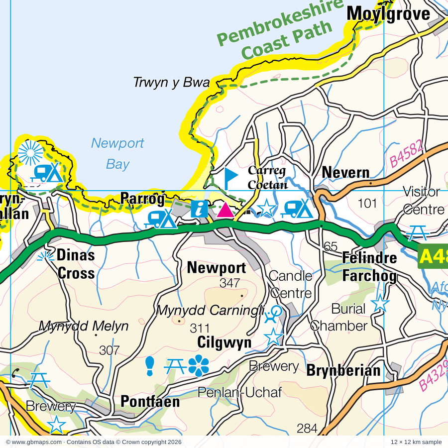
Explore the full 60 × 60 km Newport regional road map at 1:250,000, covering Newport, Aberteifi, Abergwaun, Goodwick, Narberth. Compare the complete coverage below; a detailed PDF sample is available free.
Afon Anghof, Afon Cynin, Afon Cywyn, Afon Dewi Fawr, Afon Duad, Afon Gronw, Afon Nyfer, Afon Taf, Afon Teifi, Eastern Cleddau / Cleddau Ddu, Nant Cynnen, River Solva
More waterways
Western Cleddau
Landmarks & landscape
Blackpool Mill Museum, Bluestone Brewery, Bro Meigan Gardens, Cardigan Heritage Centre, Cardigan Island Coastal Farm Park, Carmarthen Castle, Carreg Coetan, Carreg Coetan Burial Chamber, Castell Henllys (Iron Age Fort), Visitor Centre, Castell Newydd Emlyn Castle, Caws Cenarth Welsh Cheese, Cilgerran Castle, PEMBROKESHIRE COAST NATIONAL PARK
More named features
Curlew Weavers Woollen Mill, Dyfed Shire Horse Centre, Dylan Thomas's Boathouse, Folly Farm, Gwaun Valley Brewery, Hafod Hill Pottery, Haverfordwest Castle & Museum, Haverfordwest Priory (remains of), Internal Fire Museum of Power, Laugharne Castle, Llanlliwe Solar Farm, Llansteffan Castle, Llawhaden Castle, Llys-Y-Fran Reservoir Country Park, Motte and Bailey, Museum of the Welsh Woollen Industry, National Coracle Centre, New Quay Heritage Centre, New Quay Honey Farm, Oakwood Theme Park, CC 2000, Ocean Lab, Old Smithy Craftshop & Heritage Centre, Oriel Myrddin (Arts Centre), Showground, Pembrokeshire Candle Centre, Penlan-Uchaf Garden, Pentre Ifan (Burial Chamber), Picton Castle, Preseli Mohair Centre, Scolton Country Park, Scolton Manor Museum, Solva Woollen Mill, St Dogmaels Abbey, Teifi Valley Railway, Tregwynt Woollen Mill, Visitor Centre, Welsh Wildlife Centre, West Wales Museum of Childhood, Wiston Castle, Wolf's Castle Pottery, Woodturner, Y Felin (Water Mill)
Wholly or partly within the full map rectangle. These boundaries are coverage information, not additional artwork layers.
Sir Benfro - PembrokeshirePartly within
Sir Ceredigion - CeredigionPartly within
Sir Gaerfyrddin - CarmarthenshirePartly within
Wards & electoral divisions 57 areas
Aberporth and Y Ferwig ED
Amroth and Saundersfoot North ED (part)
Beulah and Llangoedmor ED
Boncath and Clydau ED
Bro Gwaun ED
Burton ED (part)
Camrose ED
Carew and Jeffreyston ED (part)
Carmarthen Town North and South ED (part)
Carmarthen Town West ED (part)
Cenarth and Llangeler ED (part)
Cilgerran and Eglwyswrw ED
Crymych and Mynachlog-ddu ED
Cynwyl Elfed ED (part)
Fishguard: North East ED
Fishguard: North West ED
Goodwick ED
Haverfordwest: Castle ED
Haverfordwest: Garth ED
Haverfordwest: Portfield ED
Haverfordwest: Prendergast ED
Haverfordwest: Priory ED
Johnston ED (part)
Kidwelly and St. Ishmael ED (part)
Kilgetty and Begelly ED (part)
Lampeter Velfrey ED (part)
Laugharne Township ED (part)
Letterston ED
Llanboidy ED
Llandyfriog ED (part)
Llandysilio and Llangrannog ED (part)
Llandysul North and Troedyraur ED (part)
Llandysul South ED (part)
Llangwm ED (part)
Llangyndeyrn ED (part)
Llannarth ED (part)
Llanrhian ED (part)
Maenclochog ED
Martletwy ED (part)
Merlin's Bridge ED
Mwldan ED
Narberth: Rural ED (part)
Narberth: Urban ED
New Quay and Llanllwchaearn ED (part)
Newport and Dinas ED
Penbryn ED
Rudbaxton and Spittal ED
Solva ED (part)
St. Clears and Llansteffan ED (part)
St. David's ED (part)
St. Dogmaels ED
St. Ishmael's ED (part)
Teifi ED
The Havens ED
Trelech ED (part)
Whitland ED
Wiston ED
Civil parishes & communities 97 areas
Abernant Community
Aberporth Community
Ambleston Community
Amroth Community (part)
Beulah Community
Boncath Community
Brawdy Community
Bronwydd Community (part)
Camrose Community
Cardigan Community
Carmarthen Community (part)
Cenarth Community
Cilgerran Community
Cilymaenllwyd Community
Clunderwen Community
Clydau Community
Crymych Community
Cwm Gwaun Community
Cynwyl Elfed Community (part)
Dinas Cross Community
Eglwyscummin Community (part)
Eglwyswrw Community
Fishguard and Goodwick Community
Freystrop Community (part)
Haverfordwest Community
Hayscastle Community
Henllanfallteg Community
Hook Community
Jeffreyston Community (part)
Johnston Community (part)
Kilgetty/Begelly Community (part)
Lampeter Velfrey Community (part)
Laugharne Township Community (part)
Letterston Community
Llanarth Community (part)
Llanboidy Community
Llanddewi Velfrey Community
Llanddowror Community (part)
Llandissilio West Community
Llandyfaelog Community (part)
Llandyfriog Community (part)
Llandysiliogogo Community (part)
Llandysul Community (part)
Llangain Community (part)
Llangeler Community (part)
Llangoedmor Community
Llangrannog Community
Llangwm Community (part)
Llangynin Community
Llangynog Community
Llanllwchaiarn Community (part)
Llanpumsaint Community (part)
Llanrhian Community (part)
Llansteffan Community (part)
Llanwinio Community
Llawhaden Community
Maenclochog Community
Manordeifi Community
Marloes and St. Brides Community (part)
Martletwy Community (part)
Mathry Community
Meidrim Community
Merlin's Bridge Community
Mynachlogddu Community
Narberth Community
Nevern Community
New Moat Community
New Quay Community (part)
Newcastle Emlyn Community
Newchurch and Merthyr Community (part)
Newport Community
Nolton and Roch Community
Penbryn Community
Pencaer Community
Pendine Community (part)
Puncheston Community
Rosemarket Community (part)
Rudbaxton Community
Scleddau Community
Solva Community (part)
Spittal Community
St. Clears Community
St. David's Community (part)
St. Dogmaels Community
St. Ishmael Community (part)
St. Ishmael's Community (part)
Templeton Community (part)
The Havens Community
Tiers Cross Community (part)
Trelech Community
Troedyraur Community
Uzmaston, Boulston and Slebech Community
Walwyn's Castle Community (part)
Whitland Community
Wiston Community
Wolfscastle Community
Y Ferwig Community
Source: the GBMaps road atlas, OS Boundary-Line and postcode mapping datasets. Source editions are being checked for publication. Unmarked boundary names are wholly within the sheet; “part” means the map edge crosses the area.
INSIDE YOUR DOWNLOAD
A proper road map, in useful formats
Road classifications, towns and villages, railways, rivers, landscape detail and tourist symbols, brought together in the GBMaps regional road atlas style.
PDF for the finished map. SVG and layered Illustrator artwork for adapting colours, adding your own information and preparing designs.
THE FINISHED SHEET
Designed for print and presentation
Map coverage
60 × 60 km
Sample coverage
12 × 12 km
Print layout
A3 landscape · enlarged 1:250k cartography
Sheet furniture
Border, scale bar, key & north arrow
A few useful details
What changes when I select another square?
Select a surrounding square to bring it into the centre and reveal the maps around it. Each square is a different 60 × 60 km map. The preview, free sample and selected download change together. Neighbouring sheets overlap by 30 km so you can choose the coverage that suits you.
Is the free sample a vector map?
The on-page detail is an SVG. The free download is a separate 12 × 12 km PDF with a link to the full map. Please retain its copyright credits and product link when sharing it.
Can I buy a larger combined map?
These downloads are individual ready-made sheets. Contact GBMaps if you need a larger combined area.