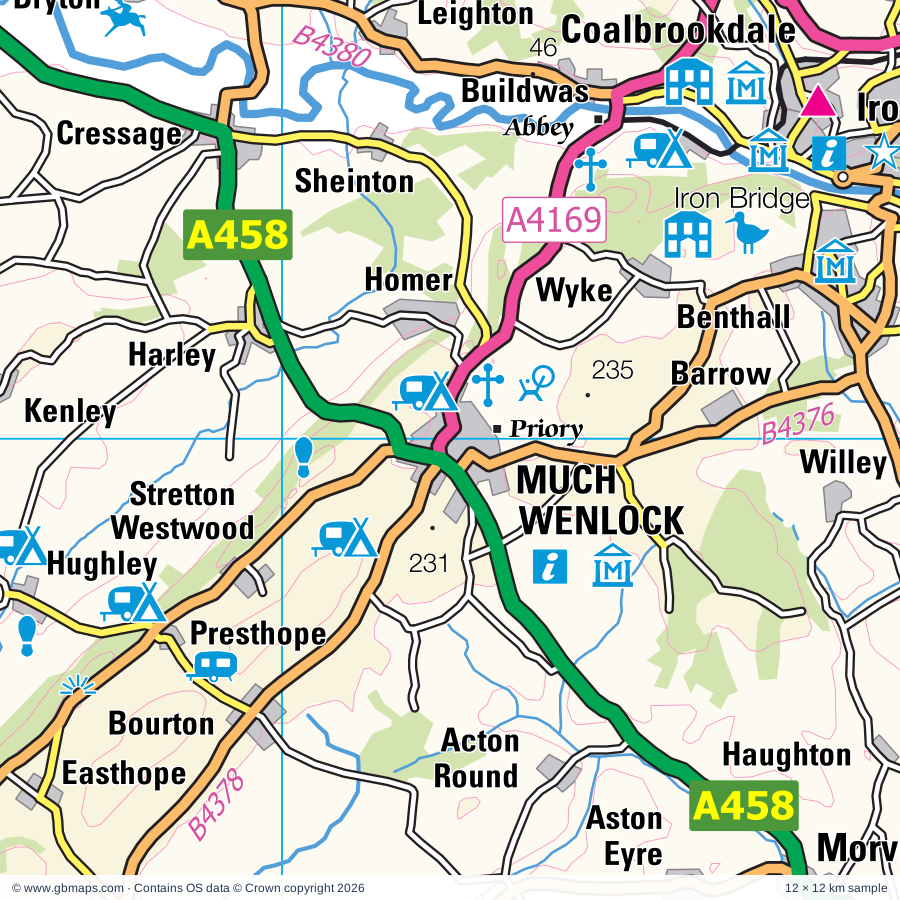
Much Wenlock regional road map. Full 60 × 60 km PDF, SVG and Illustrator files, with a free PDF sample.

GBMAPS.COM

Much Wenlock Regional Road Map

Call Us Now for Help01751 473136

GREAT BRITAIN ROAD ATLAS · 1:250,000 GB-360-0300

Much Wenlock & surrounding area

Explore the full 60 × 60 km Much Wenlock regional road map at 1:250,000, covering Broseley, Telford, Bridgnorth, Ludlow, Wem. Compare the complete coverage below; a detailed PDF sample is available free.

MUCH WENLOCK & SURROUNDING AREAREGIONAL ROAD MAP
60 × 60 km · Full map previewDownload the free SVG ↓

INSIDE THE FULL 60 × 60 KM MAP

Explore the Much Wenlock map area

1:250,000 cartography

Towns, villages & places

More mapped places (397)
  • Barrow
  • Easthope
  • Buildwas
  • Dryton
  • Acton Pigott
  • Cound
  • Brockton
  • Ruckley
  • Benthall
  • Monkhopton
  • Weston
  • Willey
  • Pitchford
  • Donnington
  • Plaish
  • Rushton
  • Frodesley
  • Shipton
  • Morville
  • Haughton
  • Wroxeter
  • Uppington
  • Nordley
  • Aston
  • Gretton
  • Cantlop
  • Berrington
  • Norton
  • Enchmarsh
  • Cardington
  • Atcham
  • Longnor
  • Holdgate
  • Chetton
  • Tasley
  • Little Ryton
  • Great Ryton
  • Broadstone
  • Cross Lane Head
  • Rushbury
  • Wall Bank
  • Condover
  • Walcot
  • Brockton
  • Leebotwood
  • Dorrington
  • Neenton
  • Norton
  • Stockton
  • Tugford
  • Oldbury
  • Stapleton
  • Abdon
  • Kemberton
  • Eaton
  • Allscott
  • Rodington
  • Munslow
  • Ticklerton
  • Woolstaston
  • Bayston Hill
  • Burwarton
  • Heath
  • Glazeley
  • Grindle
  • Swancote
  • Middlehope
  • Eardington
  • Uffington
  • Bouldon
  • Ryton
  • Picklescott
  • Worfield
  • Sleapford
  • Roughton
  • Harton
  • Hatton
  • Haughton
  • Beckbury
  • Quatford
  • Peaton
  • Sidbury
  • Badger
  • Roden
  • Annscroft
  • Longden
  • Shifnal
  • Loughton
  • Wyken
  • Chelmarsh
  • Ackleton
  • Diddlebury
  • Pulverbatch
  • Hilton
  • Poynton
  • Corfton
  • Kynnersley
  • Oaks
  • Walton
  • Crudgington
  • Billingsley
  • Stottesdon
  • Westhope
  • Sutton
  • Hanwood
  • Chesterton
  • Plealey
  • Marshbrook
  • Alcaston
  • Cleedownton
  • Crackleybank
  • Minton
  • Cruckmeole
  • Hampton
  • Quatt
  • Cruckton
  • Waters Upton
  • Farlow
  • Rowton
  • Astley
  • Lilyhurst
  • Ratlinghope
  • Pontesford
  • Seifton
  • Oreton
  • Whittingslow
  • Lea
  • Claverley
  • Lilleshall
  • Habberley
  • Hinton
  • Silvington
  • Ludstone
  • Bridges
  • Tong
  • Pontesbury
  • Culmington
  • Muckleton
  • Cherrington
  • Adeney
  • Albrighton
  • Strefford
  • Shipley
  • Bicton
  • Nox
  • Hadnall
  • Albrighton
  • Shawbury
  • Woolston
  • Highley
  • Tibberton
  • Edge
  • Shoot Hill
  • Asterton
  • Edgebolton
  • Upper Aston
  • Pattingham
  • Wistanstow
  • Tuckhill
  • Catherton
  • Boningale
  • Yockleton
  • Six Ashes
  • Longford
  • Alveley
  • Birdsgreen
  • Shackerley
  • Wentnor
  • Farley
  • Heathton
  • Snailbeach
  • Bitterley
  • Horderley
  • Kinlet
  • Edgmond
  • Leaton
  • Ford
  • Minsterley
  • Woodcote
  • Norton
  • Forton
  • Montford
  • Myndtown
  • Halford
  • Ploxgreen
  • Asterley
  • Fitz
  • Middleton
  • Wagbeach
  • Farden
  • Cardeston
  • Doddington
  • Blymhill
  • Henley
  • Seisdon
  • The Bog
  • Ridgway
  • Merrington
  • Grafton
  • Cleehill
  • Westley
  • Pennerley
  • Norbury
  • Grinshill
  • Harmer Hill
  • Eaton
  • Romsley
  • Brineton
  • Snitton
  • Hints
  • Stretton Heath
  • Peplow
  • Shrawardine
  • Besford
  • Plowden
  • Knowbury
  • Trescott
  • Ensdon
  • Yeaton
  • Howle
  • Moreton
  • Yorton
  • Trysull
  • Edgton
  • Knowle
  • Orslow
  • Onibury
  • Clive
  • Booley
  • Upper Arley
  • Oaken
  • Wootton
  • Bromfield
  • Eyton
  • Linley
  • Hope
  • Ollerton
  • Alderton
  • Westbury
  • Enville
  • Puleston
  • Rowton
  • Forton
  • Pickstock
  • Shelve
  • Walford
  • Coreley
  • Gravels
  • Perton
  • Shatterford
  • Codsall
  • Hopesay
  • Totterton
  • Buttonoak
  • Sambrook
  • Leigh
  • Lower Penn
  • Whitton
  • Lea
  • Milson
  • Myddle
  • More
  • Caynham
  • Marston
  • Wombourne
  • Broome
  • Sutton
  • Worthen
  • Lydham
  • High Onn
  • Swindon
  • Hinstock
  • Vennington
  • Sleap
  • Alberbury
  • Bilbrook
  • Bayton
  • Kingsford
  • Baschurch
  • Nash
  • Ellerton
  • Brockton
  • Trimpley
  • Aston
  • Kinver
  • Meadowtown
  • Wilcott
  • Weston
  • High Heath
  • Nesscliffe
  • Himley
  • Hyssington
  • Kempton
  • Greete
  • Clungunford
  • Stourton
  • Pentre
  • Shelderton
  • Marchamley
  • Overton
  • Burlton
  • Snead
  • Brewood
  • Boraston
  • Wollaston
  • Blakeshall
  • Mill Green
  • Wistanswick
  • Norbury
  • The Marsh
  • Rorrington
  • Mamble
  • Lapley
  • Callow Hill
  • Clunbury
  • Rowley
  • Low Habberley
  • Kinton
  • Binweston
  • Shebdon
  • Stretton
  • Purslow
  • Wolverley
  • Brockton
  • Knighton
  • Colebatch
  • Petton
  • Edgerley
  • Gnosall
  • Twitchen
  • Bliss Gate
  • Noneley
  • Cookley
  • Whittington
  • Caunsall
  • Melverley
  • Crewgreen
  • Hoptonheath
  • Soudley
  • Rock
  • Kinton
  • Loppington
  • Ribbesford
  • Cheswardine
  • Burrington
  • Middletown
  • Mitton
  • Wykey
  • Woodseaves
  • Leintwardine
  • Acton
  • Clunton
  • Elton
  • Whiston
  • Dovaston
  • Adbaston
  • Crosslanes
  • Bradley
  • Criggion
  • Haughton
  • Cockshutt
  • Kinnerley
  • Bagley
  • Bedstone
  • Eardiston
  • Lawnhead
  • Levedale
  • Buckton
  • Walford
  • Churchill
  • Whitecross
  • Knockin
  • Weirbrook
  • Ranton
  • Adforton
  • Haughton
  • Blakedown
  • Clun
  • Wilden
  • Ellenhall
  • Bucknell
  • Grimpo
  • Stone
  • Rednal
  • Pershall
  • Derrington
  • Woolston
  • Letton
  • Shenstone
  • Harvington
  • Hartlebury
  • Chebsey
  • Stowe
  • Maesbury
  • Ball
  • Middleton
  • Rushock

Roads across this sheet

M6, M54, A5, A41, A49, A53, A442, A448, A449, A450, A451, A454, A456, A458, A461, A463, A464, A488, A489, A491, A518, A519, A528, A529

More road numbers

A4025, A4101, A4102, A4110, A4113, A4117, A4169, A4535, A4640, A5013, A5064, A5112, A5124, A5191, A5223, B4161, B4175, B4176, B4178, B4180, B4186, B4188, B4189, B4190, B4193, B4194, B4195, B4196, B4199, B4201, B4202, B4214, B4358, B4361, B4363, B4364, B4365, B4367, B4368, B4369, B4370, B4371, B4373, B4375, B4376, B4378, B4379, B4380, B4383, B4385, B4386, B4387, B4393, B4394, B4396, B4397, B4398, B4473, B4499, B4530, B4537, B4549, B4555, B4579, B5009, B5012, B5026, B5061, B5062, B5063, B5065, B5067, B5314, B5405, B5476, B5477

Rivers & waterways

Borle Brook, Cound Brook, Ledwyche Brook, Montgomery Canal, Rea Brook, River Clun, River Corve, River East Onny, River Onny, River Penk, River Perry, River Rea

More waterways

River Roden, River Severn, River Sow, River Stour, River Teme, River Tern, River Vyrnwy / Afon Efyrnwy, River West Onny, River Worfe, Shropshire Union Canal, Staffordshire & Worcestershire Canal, Stourbridge Canal

Landmarks & landscape

Abbey, Acton Burnell Castle, Acton Scott Working Farm, Aqualate Hall, Arley Estate Arboretum, Attingham, Attingham Park, Aviation Museum, Baggeridge Country Park, Bantock House Museum, Battlefield 1403 Exhibition Centre, Benthall Hall

More named features

Bewdley Museum, Blackstone Meadows Country Park, Blists Hill Victorian Town, Bodenham Arboretum and Earth Centre, Boscobel House, Bridgnorth Castle, Broadfield House Glass Museum, Broseley Pipe Works, Museum of the Gorge, Police Museum, Buildwas Abbey, Bury Ditches, Cantlop Bridge, Carding Mill Valley, Chaddesley Corbett Point to Point Course, Chillington Hall, Clunton Coppice Nature Reserve, Coalbrookdale Museum of Iron, Enginuity, Coalport China Museum, Jackfield Tile Museum, Craft Centre, Daniel's Mill, Darby Houses, David Austin Roses Ltd, Devil's Spittleful Nature Reserve, Dudmaston Hall, Eastridge Wood Cycle Trail, Elton Hall Garden, Eyton on Severn Point to Point Racecourse, Gentleshaw Wildlife Centre, Granville Country Park, Halfpenny Green Vineyard, Hartlebury Castle, Hartlebury Common Nature Reserve, Harvington Hall, Haughmond Abbey, Hawkstone Park and Visitor Centre, Hayford Solar Farm, Highgate Common, Himley Hall, Hodnet Gardens, Holy Austin Rock Houses, Home Farm Attingham, Hoo Farm, Hopton Mountain Bike Trails, House on Crutches Museum, Bishop's Castle Railway Museum, Ironbridge Gorge (World Heritage Site), Ironbridge Gorge Tourist Visitor Centre, Isaak Waltons Cottage & Museum, Kidderminster Railway Museum, Museum of Carpet, Kingsford Country Park, Kinver Edge, Langley Chapel, Leapgate Country Park, Lilleshall Abbey, Ludlow Castle, Ludlow Museum, Ludlow Racecourse, Lyth Hill Country Park, Mark Griffiths Pottery, Merridale Nature Reserve, Mitchell's Fold Stone Circle, Moat House, Moreton Corbet Castle, Museum, Nature Reserve, Nesscliffe Hill Country Park, Northgate Museum, Patshull Hall, Pendeford Mill Nature Reserve, Poles Coppice Nature Reserve, RAF Museum Cosford, Rays Farm Country Matters, Redhouse and Cone Museum, Remains of Bedlam Furnaces, Rowley's House Museum, Coleham Pumping Station, Shropshire Regimental Museum, Shrewsbury Museum & Art Gallery, Rowton Castle, Ruewood Meadow Nature Reserve, Severn Valley Country Park, Severn Valley Country Park (Highley Mine), Severn Valley Railway, Shipton Hall, Shrewsbury Abbey, Shrewsbury Castle, Shropshire Wildlife Centre, Major Art Galleries, Snailbeach Mine, Solar Farm, St Milburga's Priory, Stanmore Country Park, Stokesay Castle, Sunnycroft, Telford Steam Trust, The Bog Visitor Centre, The Engine House Visitor Centre, The Falconry Centre, The Gobbett Rare Breeds Farm, The Ruskin Glass Centre, The Spaceguard Centre, The Stiperstones, The Wernlas Collection, Tudor Crystal, Visitor Centre, Walcot, Walcot Hall Gardens and Aboretum, Wallerton Old Hall Garden, Wenlock Pottery, West Midland Safari & Leisure Park, Westo Wood Fisheries, Weston Park, Weston Park & Deer Park, Whightwick Manor, Whit Lenge Gardens, White Ladies Priory, Wilderhope Manor, Wolverhampton Racecourse, Worcestershire County Museum, Wrockwardine Solar Farm, Wroxeter Roman City, Wroxeter Roman City and Museum, Wroxeter Roman Vineyard, Wyre Valley Visitor Centre, Go Ape Wyre
Local authority & parish coverage

Wholly or partly within the full map rectangle. These boundaries are coverage information, not additional artwork layers.

  • Bromsgrove DistrictPartly within
  • City of Wolverhampton DistrictPartly within
  • County of HerefordshirePartly within
  • Dudley DistrictPartly within
  • Malvern Hills DistrictPartly within
  • Powys - PowysPartly within
  • ShropshirePartly within
  • South Staffordshire DistrictPartly within
  • Stafford DistrictPartly within
  • Telford and WrekinWholly within
  • Wychavon DistrictPartly within
  • Wyre Forest DistrictPartly within
Wards & electoral divisions 155 areas
  • Admaston & Bratton Ward
  • Aggborough & Spennells Ward
  • Amblecote Ward (part)
  • Apley Castle Ward
  • Areley Kings & Riverside Ward (part)
  • Arleston & College Ward
  • Baldwin Ward (part)
  • Bewdley & Rock Ward (part)
  • Bilbrook Ward (part)
  • Bircher Ward (part)
  • Blakebrook & Habberley South Ward
  • Brewood, Coven & Blymhill Ward (part)
  • Brierley Hill & Wordsley South Ward (part)
  • Broadwaters Ward
  • Brockmoor & Pensnett Ward (part)
  • Brookside Ward
  • Church Aston & Lilleshall Ward
  • Codsall Ward
  • Dawley & Aqueduct Ward
  • Dodderhill Ward (part)
  • Donnington Ward
  • Doxey & Castletown Ward (part)
  • Eccleshall Ward (part)
  • Edgmond Ward
  • Ercall Magna Ward
  • Ercall Ward
  • Foley Park & Hoobrook Ward
  • Franche & Habberley North Ward
  • Gnosall & Woodseaves Ward
  • Gornal Ward (part)
  • Graiseley Ward (part)
  • Hadley & Leegomery Ward
  • Hagley West Ward (part)
  • Hartlebury Ward (part)
  • Haygate & Park Ward
  • Himley & Swindon Ward (part)
  • Holmcroft Ward (part)
  • Horsehay & Lightmoor Ward
  • Ironbridge Gorge Ward
  • Ketley Ward
  • Kingswinford North & Wall Heath Ward (part)
  • Kingswinford South Ward (part)
  • Kinver & Enville Ward
  • Lapley, Stretton & Wheaton Aston Ward (part)
  • Lawley Ward
  • Leominster North & Rural Ward (part)
  • Lickhill Ward
  • Lindridge Ward (part)
  • Madeley & Sutton Hill Ward
  • Malinslee & Dawley Bank Ward
  • Merry Hill Ward
  • Mitton Ward (part)
  • Mortimer Ward (part)
  • Muxton Ward
  • Newport East Ward
  • Newport North Ward
  • Newport South Ward
  • Newport West Ward
  • Norton Ward (part)
  • Oakengates & Ketley Bank Ward
  • Offmore & Comberton Ward
  • Overdale & The Rock Ward
  • Oxley Ward (part)
  • Park Ward (part)
  • Pattingham, Trysull, Bobbington & Lower Penn Ward
  • Penkridge North & Acton Trussell Ward (part)
  • Penn Ward (part)
  • Perton East Ward
  • Perton Lakeside Ward
  • Perton Wrottesley Ward
  • Priorslee Ward
  • Rowley Ward (part)
  • Seighford & Church Eaton Ward (part)
  • Shawbirch & Dothill Ward
  • St. Georges Ward
  • St. Peters Ward (part)
  • Tettenhall Regis Ward (part)
  • Tettenhall Wightwick Ward
  • The Nedge Ward
  • Wollaston & Stourbridge Town Ward (part)
  • Wombourne North Ward (part)
  • Wombourne South Ward
  • Woodside Ward
  • Wordsley North Ward (part)
  • Wribbenhall & Arley Ward
  • Wrockwardine Ward
  • Wrockwardine Wood & Trench Ward
  • Wyre Forest Rural Ward (part)
  • Abbey ED
  • Albrighton ED
  • Bagley ED
  • Battlefield ED
  • Bayston Hill ED
  • Belle Vue ED
  • Bicton Heath ED
  • Bishop's Castle ED (part)
  • Bridgnorth Castle ED
  • Bridgnorth East ED
  • Bridgnorth South & Alveley ED
  • Bridgnorth West & Tasley ED
  • Broseley ED
  • Brown Clee ED
  • Burnell ED
  • Castlefields & Ditherington ED
  • Cheswardine ED (part)
  • Chirbury & Worthen ED (part)
  • Churchstoke ED (part)
  • Claverley & Worfield ED
  • Clee ED (part)
  • Cleobury Mortimer ED (part)
  • Clun ED (part)
  • Column & Sutton ED
  • Copthorne ED
  • Corvedale ED
  • Craven Arms ED
  • Harlescott ED
  • Highley ED
  • Hodnet ED (part)
  • Knighton with Beguildy ED (part)
  • Llandrinio ED (part)
  • Llandysilio ED (part)
  • Llangunllo with Norton ED (part)
  • Llanymynech ED (part)
  • Longden ED
  • Loton ED
  • Ludlow East ED
  • Ludlow North ED
  • Ludlow South ED (part)
  • Meole ED
  • Monkmoor ED
  • Much Wenlock ED
  • Oswestry North East ED (part)
  • Oswestry South East ED (part)
  • Oteley & Reabrook ED
  • Porthill ED
  • Quarry & Coton Hill ED
  • Radbrook ED
  • Rea Valley ED
  • Ruyton & Baschurch ED (part)
  • Severn Valley ED
  • Shawbury ED
  • Shifnal North ED
  • Shifnal Rural ED
  • Shifnal South ED
  • St. Martin's ED (part)
  • St. Oswald ED (part)
  • Stottesdon, Kinlet & Hopton Wafers ED
  • Sundorne & Old Heath ED
  • Tern ED
  • The Meres ED (part)
  • The Strettons ED
  • Trelystan and Trewern ED (part)
  • Underdale ED
  • Wem ED (part)
  • Whittington ED (part)
Civil parishes & communities 286 areas
  • Abdon and Heath CP
  • Acton Burnell CP
  • Acton Round CP
  • Acton Scott CP
  • Adbaston CP (part)
  • Adforton CP (part)
  • Alberbury with Cardeston CP
  • Albrighton and Donington CP
  • All Stretton CP
  • Alveley CP
  • Ashford Bowdler CP (part)
  • Ashford Carbonel CP (part)
  • Astley Abbotts CP
  • Astley CP
  • Astley and Dunley CP (part)
  • Aston Botterell CP
  • Aston Eyre CP
  • Atcham CP
  • Aymestrey CP (part)
  • Badger CP
  • Barrow CP
  • Baschurch CP
  • Bausley with Criggion Community (part)
  • Bayston Hill CP
  • Bayton CP
  • Beckbury CP
  • Bedstone CP
  • Berrington CP
  • Bewdley CP
  • Bicton CP
  • Bilbrook CP (part)
  • Billingsley CP
  • Bishop's Castle CP (part)
  • Bitterley CP
  • Blymhill and Weston-under-Lizard CP
  • Bobbington CP
  • Bomere Heath and District CP
  • Boningale CP
  • Boraston CP (part)
  • Bradley CP (part)
  • Brampton Bryan CP (part)
  • Brewood and Coven CP (part)
  • Bridgnorth CP
  • Bromfield CP
  • Broome CP (part)
  • Broseley CP
  • Bucknell CP
  • Buckton and Coxall CP
  • Buildwas CP
  • Burford CP (part)
  • Burrington CP
  • Burwarton CP
  • Cardington CP
  • Caynham CP
  • Chaddesley Corbett CP (part)
  • Chebsey CP (part)
  • Chelmarsh CP
  • Cheswardine CP (part)
  • Chetton CP
  • Chetwynd Aston and Woodcote CP
  • Chetwynd CP
  • Child's Ercall CP
  • Chirbury with Brompton CP (part)
  • Church Aston CP
  • Church Eaton CP
  • Church Preen CP
  • Church Pulverbatch CP
  • Church Stretton CP
  • Churchill and Blakedown CP
  • Churchstoke Community (part)
  • Claverley CP
  • Clee St. Margaret CP
  • Cleobury Mortimer CP
  • Cleobury North CP
  • Clive CP
  • Clun CP (part)
  • Clunbury CP
  • Clungunford CP
  • Cockshutt CP (part)
  • Codsall CP
  • Colebatch CP (part)
  • Condover CP
  • Coppenhall CP (part)
  • Coreley CP
  • Cound CP
  • Craven Arms CP
  • Cressage CP
  • Creswell CP (part)
  • Culmington CP
  • Dawley Hamlets CP
  • Deuxhill CP
  • Diddlebury CP
  • Ditton Priors CP
  • Donnington and Muxton CP
  • Downton CP
  • Doxey CP (part)
  • Dunston CP (part)
  • Eardington CP
  • Easthope CP
  • Eaton-under-Heywood CP
  • Eccleshall CP (part)
  • Edgmond CP
  • Edgton CP
  • Ellenhall CP
  • Ellesmere Rural CP (part)
  • Elmbridge CP (part)
  • Elmley Lovett CP (part)
  • Elton CP (part)
  • Enville CP
  • Ercall Magna CP
  • Eyton upon the Weald Moors CP
  • Farlow CP
  • Ford CP
  • Forton CP
  • Frodesley CP
  • Glazeley CP
  • Gnosall CP
  • Great Dawley CP
  • Great Hanwood CP
  • Great Ness CP
  • Greete CP (part)
  • Grinshill CP
  • Hadley and Leegomery CP
  • Hadnall CP
  • Hagley CP (part)
  • Harley CP
  • Hartlebury CP (part)
  • Haughton CP
  • High Offley CP
  • Highley CP
  • Himley CP (part)
  • Hinstock CP
  • Hodnet CP (part)
  • Hollinswood and Randlay CP
  • Hope Bagot CP
  • Hope Bowdler CP
  • Hopesay CP
  • Hopton Cangeford CP
  • Hopton Castle CP
  • Hopton Wafers CP
  • Hordley CP (part)
  • Hughley CP
  • Hyde Lea CP (part)
  • Kemberton CP
  • Kenley CP
  • Ketley CP
  • Kidderminster CP
  • Kidderminster Foreign CP
  • Kinlet CP
  • Kinnerley CP (part)
  • Kinver CP
  • Knighton Community (part)
  • Knighton on Teme CP (part)
  • Knockin CP
  • Kynnersley CP
  • Lapley, Stretton and Wheaton Aston CP (part)
  • Lawley and Overdale CP
  • Leebotwood CP
  • Leighton and Eaton Constantine CP
  • Leinthall Starkes CP (part)
  • Leintwardine CP
  • Lilleshall CP
  • Lindridge CP (part)
  • Little Hereford CP (part)
  • Little Ness CP
  • Little Wenlock CP
  • Llandrinio Community (part)
  • Llandysilio Community (part)
  • Longden CP
  • Longnor CP
  • Loppington CP (part)
  • Lower Penn CP
  • Ludford CP
  • Ludlow CP
  • Lydbury North CP (part)
  • Lydham CP (part)
  • Madeley CP
  • Mamble CP (part)
  • Melverley CP
  • Middleton Scriven CP
  • Milson CP
  • Minsterley CP
  • Monkhopton CP
  • Montford CP
  • More CP
  • Moreton Corbet and Lee Brockhurst CP
  • Morville CP
  • Much Wenlock CP
  • Munslow CP
  • Myddle, Broughton and Harmer Hill CP
  • Myndtown CP
  • Nash CP (part)
  • Neen Savage CP
  • Neen Sollars CP
  • Neenton CP
  • Newport CP
  • Norbury CP
  • Norbury CP
  • Oakengates CP
  • Onibury CP
  • Oswestry CP (part)
  • Oswestry Rural CP (part)
  • Pattingham and Patshull CP
  • Penkridge CP (part)
  • Perton CP
  • Petton CP
  • Pipe Aston CP
  • Pitchford CP
  • Pontesbury CP
  • Presteigne Community (part)
  • Preston upon the Weald Moors CP
  • Quatt Malvern CP
  • Ranton CP
  • Ratlinghope CP
  • Ribbesford CP
  • Richard's Castle (Shropshire) CP (part)
  • Richards Castle (Hereford) CP (part)
  • Rock CP (part)
  • Rodington CP
  • Romsley CP
  • Ruckley and Langley CP
  • Rudge CP
  • Rushbury CP
  • Rushock CP (part)
  • Ruyton-XI-Towns CP
  • Ryton CP
  • Seighford CP (part)
  • Shawbury CP
  • Sheinton CP
  • Sheriffhales CP
  • Shifnal CP
  • Shipton CP
  • Shrewsbury CP
  • Sibdon Carwood CP
  • Sidbury CP
  • Smethcott CP
  • St. Georges and Priorslee CP
  • Stanton Lacy CP
  • Stanton Long CP
  • Stanton upon Hine Heath CP
  • Stirchley and Brookside CP
  • Stockton CP
  • Stoke St. Milborough CP
  • Stoke upon Tern CP (part)
  • Stone CP
  • Stottesdon CP
  • Stourport-on-Severn CP (part)
  • Stowe CP (part)
  • Sutton Maddock CP
  • Sutton upon Tern CP (part)
  • Swindon CP
  • Tasley CP
  • The Gorge CP
  • Tibberton and Cherrington CP
  • Tong CP
  • Trewern Community (part)
  • Trysull and Seisdon CP
  • Uffington CP
  • Upper Arley CP
  • Upton Cressett CP
  • Upton Magna CP
  • Walford, Letton and Newton CP (part)
  • Waters Upton CP
  • Wellington CP
  • Wem Rural CP (part)
  • Wem Urban CP (part)
  • Wentnor CP
  • West Felton CP
  • Westbury CP (part)
  • Weston-under-Redcastle CP (part)
  • Wheathill CP
  • Whitgreave CP (part)
  • Whittington CP (part)
  • Whitton CP
  • Wigmore CP (part)
  • Willey CP (part)
  • Wistanstow CP
  • Withington CP
  • Wolverley and Cookley CP
  • Wombourne CP (part)
  • Woolstaston CP
  • Worfield CP
  • Worthen with Shelve CP (part)
  • Wrockwardine CP
  • Wrockwardine Wood and Trench CP
  • Wroxeter and Uppington CP

Source: the GBMaps road atlas, OS Boundary-Line and postcode mapping datasets. Source editions are being checked for publication. Unmarked boundary names are wholly within the sheet; “part” means the map edge crosses the area.

Place lists are selected from the map source, not a complete gazetteer. Named features describe the cartography; visitor facilities and opening status are not verified. The free sample covers only 12 × 12 km of this larger sheet.

INSIDE YOUR DOWNLOAD

A proper road map, in useful formats

Road classifications, towns and villages, railways, rivers, landscape detail and tourist symbols, brought together in the GBMaps regional road atlas style.

PDF filePDFSVG fileSVGAdobe Illustrator AI fileAi

PDF for the finished map. SVG and layered Illustrator artwork for adapting colours, adding your own information and preparing designs.

THE FINISHED SHEET

Designed for print and presentation

Map coverage
60 × 60 km
Sample coverage
12 × 12 km
Print layout
A3 landscape · enlarged 1:250k cartography
Sheet furniture
Border, scale bar, key & north arrow

A few useful details

What changes when I select another square?

Select a surrounding square to bring it into the centre and reveal the maps around it. Each square is a different 60 × 60 km map. The preview, free sample and selected download change together. Neighbouring sheets overlap by 30 km so you can choose the coverage that suits you.

Is the free sample a vector map?

The on-page detail is an SVG. The free download is a separate 12 × 12 km PDF with a link to the full map. Please retain its copyright credits and product link when sharing it.

Can I buy a larger combined map?

These downloads are individual ready-made sheets. Contact GBMaps if you need a larger combined area.

FREE PDF SAMPLE

Your free map sample

Your free 12 × 12 km sample includes a link back to this map, so you can return for the full area whenever you need it.

Download free PDF sample ↓

Get your Much Wenlock map

Map download bundle

£24.00including VATOne payment

Pay securely

One payment. Your map stays open.

Your map download

Your map files

Preparing your download…

Checking your private download link…

Your map downloads

Already bought a map?

Find the downloads from your purchases.

Enter the email address you used at checkout. We’ll email you a private link to your available map downloads.