Lynton regional road map. Full 60 × 60 km PDF, SVG and Illustrator files, with a free PDF sample.

GBMAPS.COM

Lynton Regional Road Map

Call Us Now for Help01751 473136

GREAT BRITAIN ROAD ATLAS · 1:250,000 GB-270-0150

Lynton & surrounding area

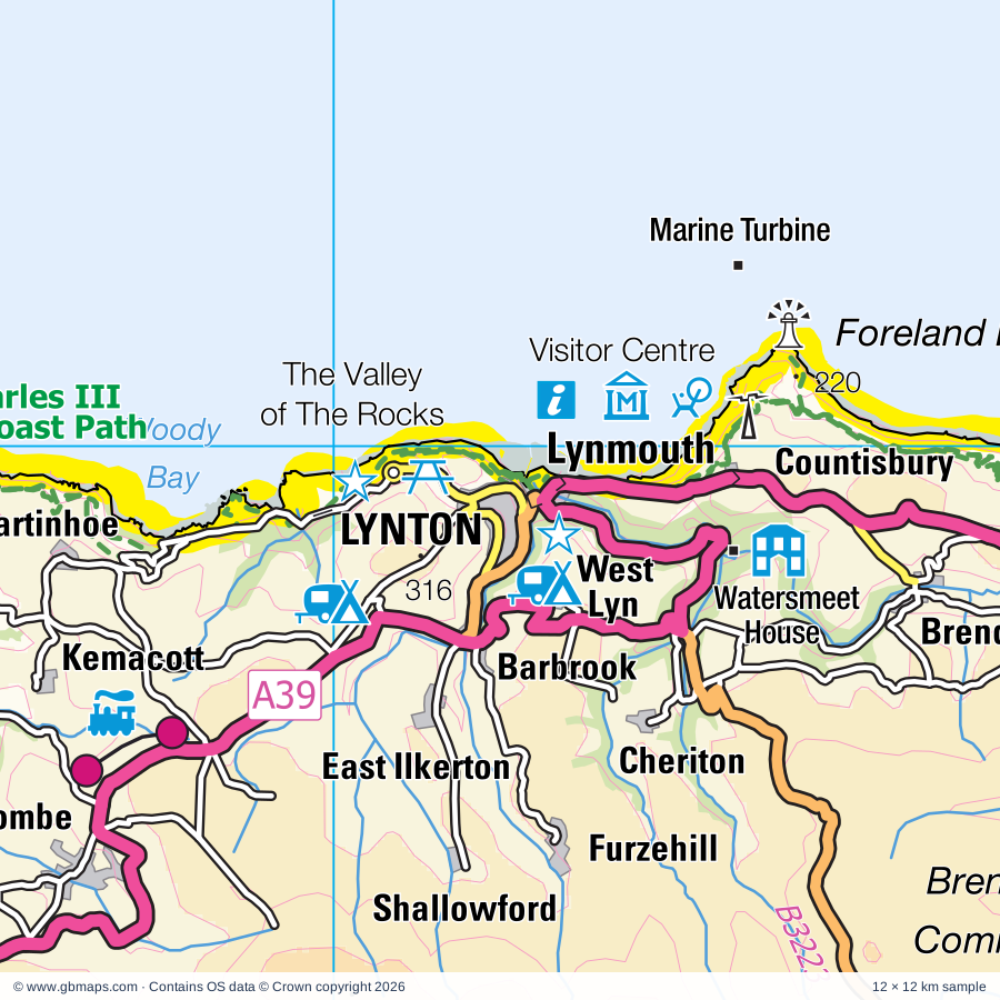
Explore the full 60 × 60 km Lynton regional road map at 1:250,000, covering Lynton, Ilfracombe, Barnstaple, Minehead, Porthcawl. Compare the complete coverage below; a detailed PDF sample is available free.

LYNTON & SURROUNDING AREAREGIONAL ROAD MAP
60 × 60 km · Full map previewDownload the free SVG ↓

INSIDE THE FULL 60 × 60 KM MAP

Explore the Lynton map area

1:250,000 cartography

Towns, villages & places

More mapped places (151)
  • Brendon
  • Blackmoor Gate
  • Challacombe
  • Kentisbury
  • Oare
  • Kentisbury Ford
  • Patchole
  • Knightacott
  • Combe Martin
  • Arlington
  • East Down
  • Simonsbath
  • Clifton
  • Lydcott
  • Loxhore
  • Berrynarbor
  • Benton
  • Brayford
  • High Bray
  • Shirwell
  • Porlock Weir
  • Hele
  • Charles
  • West Porlock
  • Gunn
  • Bittadon
  • Muddiford
  • Heasley Mill
  • Milltown
  • Goodleigh
  • Porlock
  • Exford
  • Kingsheanton
  • Guineaford
  • Marwood
  • Bossington
  • Prixford
  • West Luccombe
  • Lincombe
  • Withypool
  • Allerford
  • Westacott
  • Trimstone
  • Twitchen
  • Landkey
  • Swimbridge
  • Pippacott
  • Halsinger
  • Luccombe
  • Lee
  • Selworthy
  • Filleigh
  • Ashford
  • Lake
  • Knowle
  • Bishop's Tawton
  • Molland
  • Bickington
  • Cobbaton
  • Chivenor
  • Mortehoe
  • Tawstock
  • Woolacombe
  • Hawkridge
  • Wrafton
  • Chittlehampton
  • Cutcombe
  • Winsford
  • Georgeham
  • Fremington
  • Lobb
  • Pickwell
  • Herner
  • Clapworthy
  • Timberscombe
  • Chapelton
  • Saunton
  • Yelland
  • Bickleton
  • Satterleigh
  • Warkleigh
  • Croyde
  • Umberleigh
  • Exton
  • Bridgetown
  • Alswear
  • Ash Mill
  • Mariansleigh
  • Hiscott
  • Atherington
  • Chittlehamholt
  • Romansleigh
  • Marcross
  • Rose Ash
  • Yarnscombe
  • Knowstone
  • Horwood
  • Dunster
  • St Donat's
  • Southerndown
  • Instow
  • Monknash
  • Langridgeford
  • Appledore
  • Broughton
  • Eastleigh
  • Alverdiscott
  • Battleton
  • Roachill
  • Luxborough
  • Westleigh
  • Wick
  • Woodtown
  • Ogmore
  • Tythegston
  • Brushford
  • Merthyr Mawr
  • Bury
  • Huntshaw
  • Llandow
  • Boverton
  • High Bullen
  • Westward Ho!
  • Ewenny
  • Exebridge
  • Llanmaes
  • Sigingstone
  • Corntown
  • Colwinston
  • Landcross
  • Llanmihangel
  • Oakford
  • Oakfordbridge
  • Llysworney
  • Morebath
  • Upton
  • Abbotsham
  • Skilgate
  • Littleham
  • Llandough
  • Treoes
  • Llangan
  • Bampton
  • Penllyn
  • Monkleigh
  • Shillingford
  • Ford
  • Woodtown
  • Fairy Cross
  • Pen-y-lan
  • Llansannor

Roads across this sheet

A39, A48, A361, A377, A386, A388, A396, A399, A473, A3123, A3125, A4106, A4222, A4229, B3137, B3138, B3149, B3190, B3217, B3222, B3223, B3224, B3225, B3226

More road numbers

B3227, B3229, B3230, B3231, B3232, B3233, B3234, B3236, B3343, B3358, B4181, B4265, B4268, B4270, B4524, B4622

Rivers & waterways

Afon Ddawan / River Thaw, Afon Ewenny / Ewenny River, Dane's Brook, Little Dart River, Ogmore River / Afon Ogwr, River Barle, River Bray, River Exe, River Mole, River Taw, River Torridge, River Yeo

Landmarks & landscape

Abbotsham Activity Centre, All Terrain Quads, Arlington Court, Atlantic Outlet Shopping Centre, Atlantis Adventure Park, Bideford Railway Museum, Burton Museum and Art Gallery, Braunton Museum, Broomhill Sculpture Garden, Chambercombe Manor, Chapelgate Pottery, Chittlehampton Pottery, Cobbaton Combat Collection, EXMOOR NATIONAL PARK

More named features

Combe Martin Museum, Combe Martin Wildlife & Dinosaur Park, Coney Beach Amusement Park, Dartington Glass Factory, Dovery Manor Museum, Dunkery Vineyard, Dunster Castle, Dunster Castle and Gardens, Dunster Dolls Museum, Dunster Watermill, Ewenny Priory, Exmoor Falconry & Animal Farm, Exmoor National Park Visitor Centre (Dulverton), Exmoor National Park Visitor Centre (Dunster), Exmoor National Park Visitor Centre (Lynemouth), Lynton and Lynmouth Cliff Railway, Exmoor Zoo, Gallox Bridge, Butter Cross, Yarn Market, Glamorgan Heritage Coast Centre, Hele Mill, Hurscombe Plantation Nature Reserve, Ilfracombe Aquarium, Ilfracombe Museum, Instow Signal Box, Llanblethian Castle, Lyn & Exmoor Museum, Water Power Museum, Lynton and Barnstaple Railway, Marsh Farm Attraction, Marwood Hill Gardens, Mortehoe Cart Linhay, Mounsey Nature Reserve, Museum of Barnstaple & North Devon, Barnstaple Heritage Centre, North Devon Maritime Museum, North Devon Quads, Northam Burrows Country Park, Ogmore Castle, Porlock Visitor Centre, Porthcawl Museum, Quince Honey Farm, Seawatch Centre, Simonsbath Visitor Centre, Solar Farm, South Molton Museum, Tapeley Park Gardens, Tarr Steps, The Big Sheep Family Entertainment Park, The Downes House, The Dunkery and Horner Wood National Nature Reserve, The Mill Adventure Centre, The Valley of The Rocks, Tunnels Beaches, Ilfracombe Arts And Crafts Gallery, Verity statue, Visitor Centre, Watermouth Castle, Watermouth Castle Theme Park, Watersmeet House, West Somerset Railway, West Somerset Rural Life Museum, Woodside Craft Centre, Lyn Valley Arts
Local authority & parish coverage

Wholly or partly within the full map rectangle. These boundaries are coverage information, not additional artwork layers.

  • Bro Morgannwg - the Vale of GlamorganPartly within
  • Mid Devon DistrictPartly within
  • North Devon DistrictPartly within
  • Pen-y-bont ar Ogwr - BridgendPartly within
  • Rhondda Cynon Taf - Rhondda Cynon TafPartly within
  • SomersetPartly within
  • Torridge DistrictPartly within
Wards & electoral divisions 62 areas
  • Appledore Ward
  • Barnstaple Central Ward
  • Barnstaple with Pilton Ward
  • Barnstaple with Westacott Ward
  • Bickington Ward
  • Bideford East Ward
  • Bideford North Ward
  • Bideford South Ward
  • Bideford West Ward
  • Bishop's Nympton Ward (part)
  • Bratton Fleming Ward
  • Braunton East Ward
  • Braunton West & Georgeham Ward
  • Canonsleigh Ward (part)
  • Chittlehampton Ward (part)
  • Chulmleigh Ward (part)
  • Clare & Shuttern Ward (part)
  • Combe Martin Ward
  • Fremington Ward
  • Great Torrington Ward (part)
  • Hartland Ward (part)
  • Heanton Punchardon Ward
  • Ilfracombe East Ward
  • Ilfracombe West Ward
  • Instow Ward
  • Landkey Ward
  • Lynton & Lynmouth Ward
  • Marwood Ward
  • Monkleigh & Putford Ward (part)
  • Mortehoe Ward
  • Newport Ward
  • North Molton Ward
  • Northam Ward
  • Roundswell Ward
  • South Molton Ward
  • Tiverton Lowman Ward (part)
  • Two Rivers & Three Moors Ward (part)
  • Westward Ho! Ward
  • Witheridge Ward (part)
  • Brackla East Central ED (part)
  • Brackla East and Coychurch Lower ED (part)
  • Brackla West Central ED (part)
  • Brackla West ED (part)
  • Bridgend Central ED (part)
  • Bryntirion, laleston and Merthyr Mawr ED (part)
  • Cornelly ED (part)
  • Cowbridge ED (part)
  • Dulverton & Exmoor ED (part)
  • Dunster ED (part)
  • Llandow ED (part)
  • Llanharry ED (part)
  • Llantwit Major ED (part)
  • Minehead ED
  • Newton ED
  • Nottage ED (part)
  • Oldcastle ED
  • Pencoed and Penprysg ED (part)
  • Porthcawl East Central ED
  • Porthcawl West Central ED
  • Rest Bay ED
  • St. Athan ED (part)
  • St. Bride's Major ED
Civil parishes & communities 127 areas
  • Abbotsham CP
  • Alverdiscott CP
  • Alwington CP (part)
  • Arlington CP
  • Ashford CP
  • Atherington CP
  • Bampton CP (part)
  • Barnstaple CP
  • Berrynarbor CP
  • Bideford CP
  • Bishop's Nympton CP
  • Bishop's Tawton CP
  • Bittadon CP
  • Brackla Community (part)
  • Bratton Fleming CP
  • Braunton CP
  • Brayford CP
  • Brendon and Countisbury CP
  • Bridgend Community (part)
  • Brompton Regis CP (part)
  • Brushford CP
  • Buckland Brewer CP (part)
  • Carhampton CP (part)
  • Challacombe CP
  • Chittlehamholt CP (part)
  • Chittlehampton CP
  • Colwinston Community
  • Combe Martin CP
  • Cornelly Community (part)
  • Cowbridge with Llanblethian Community (part)
  • Coychurch Lower Community (part)
  • Cutcombe CP
  • Dulverton CP
  • Dunster CP (part)
  • East Anstey CP
  • East Down CP
  • East and West Buckland CP
  • Ewenny Community
  • Exford CP
  • Exmoor CP
  • Exton CP
  • Filleigh CP
  • Fremington CP
  • Frithelstock CP (part)
  • George Nympton CP
  • Georgeham CP
  • Goodleigh CP
  • Great Torrington CP (part)
  • Heanton Punchardon CP
  • High Bickington CP (part)
  • Horwood, Lovacott and Newton Tracey CP
  • Huntsham CP (part)
  • Huntshaw CP
  • Ilfracombe CP
  • Instow CP
  • Kentisbury CP
  • King's Nympton CP (part)
  • Knowstone CP
  • Laleston Community (part)
  • Landcross CP
  • Landkey CP
  • Littleham CP
  • Llandow Community
  • Llanfair Community (part)
  • Llangan Community (part)
  • Llanharry Community (part)
  • Llanmaes Community (part)
  • Llantwit Major Community (part)
  • Loxhore CP
  • Luccombe CP
  • Luxborough CP (part)
  • Lynton and Lynmouth CP
  • Mariansleigh CP
  • Martinhoe CP
  • Marwood CP
  • Merthyr Mawr Community (part)
  • Meshaw CP (part)
  • Minehead CP
  • Minehead Without CP
  • Molland CP
  • Monkleigh CP
  • Morebath CP
  • Mortehoe CP
  • North Molton CP
  • Northam CP
  • Oakford CP (part)
  • Oare CP
  • Parkham CP (part)
  • Parracombe CP
  • Pencoed Community (part)
  • Penllyn Community (part)
  • Pilton West CP
  • Porlock CP
  • Porthcawl Community (part)
  • Queen's Nympton CP
  • Rackenford CP (part)
  • Romansleigh CP (part)
  • Rose Ash CP (part)
  • Satterleigh and Warkleigh CP
  • Selworthy CP
  • Shirwell CP
  • Skilgate CP (part)
  • South Molton CP
  • St. Athan Community (part)
  • St. Bride's Major Community
  • St. Donats Community
  • St. Giles in the Wood CP (part)
  • Stoke Rivers CP
  • Stoodleigh CP (part)
  • Swimbridge CP
  • Tawstock CP
  • Timberscombe CP
  • Tiverton CP (part)
  • Treborough CP (part)
  • Trentishoe CP
  • Twitchen CP
  • Upton CP (part)
  • Weare Giffard CP
  • West Anstey CP
  • West Down CP
  • Westleigh CP
  • Wick Community
  • Winsford CP
  • Withycombe CP (part)
  • Withypool and Hawkridge CP
  • Wootton Courtenay CP
  • Yarnscombe CP (part)

Source: the GBMaps road atlas, OS Boundary-Line and postcode mapping datasets. Source editions are being checked for publication. Unmarked boundary names are wholly within the sheet; “part” means the map edge crosses the area.

Place lists are selected from the map source, not a complete gazetteer. Named features describe the cartography; visitor facilities and opening status are not verified. The free sample covers only 12 × 12 km of this larger sheet.

INSIDE YOUR DOWNLOAD

A proper road map, in useful formats

Road classifications, towns and villages, railways, rivers, landscape detail and tourist symbols, brought together in the GBMaps regional road atlas style.

PDF filePDFSVG fileSVGAdobe Illustrator AI fileAi

PDF for the finished map. SVG and layered Illustrator artwork for adapting colours, adding your own information and preparing designs.

THE FINISHED SHEET

Designed for print and presentation

Map coverage
60 × 60 km
Sample coverage
12 × 12 km
Print layout
A3 landscape · enlarged 1:250k cartography
Sheet furniture
Border, scale bar, key & north arrow

A few useful details

What changes when I select another square?

Select a surrounding square to bring it into the centre and reveal the maps around it. Each square is a different 60 × 60 km map. The preview, free sample and selected download change together. Neighbouring sheets overlap by 30 km so you can choose the coverage that suits you.

Is the free sample a vector map?

The on-page detail is an SVG. The free download is a separate 12 × 12 km PDF with a link to the full map. Please retain its copyright credits and product link when sharing it.

Can I buy a larger combined map?

These downloads are individual ready-made sheets. Contact GBMaps if you need a larger combined area.

FREE PDF SAMPLE

Your free map sample

Your free 12 × 12 km sample includes a link back to this map, so you can return for the full area whenever you need it.

Download free PDF sample ↓

Get your Lynton map

Map download bundle

£24.00including VATOne payment

Pay securely

One payment. Your map stays open.

Your map download

Your map files

Preparing your download…

Checking your private download link…

Your map downloads

Already bought a map?

Find the downloads from your purchases.

Enter the email address you used at checkout. We’ll email you a private link to your available map downloads.