Knighton regional road map. Full 60 × 60 km PDF, SVG and Illustrator files, with a free PDF sample.

GBMAPS.COM

Knighton Regional Road Map

Call Us Now for Help01751 473136

GREAT BRITAIN ROAD ATLAS · 1:250,000 GB-330-0270

Knighton & surrounding area

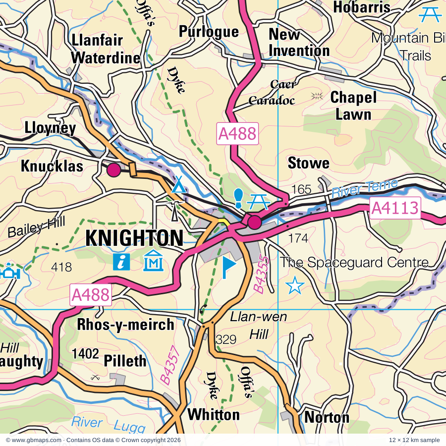
Explore the full 60 × 60 km Knighton regional road map at 1:250,000, covering Knighton, Presteigne, Kington, Ludlow, Leominster. Compare the complete coverage below; a detailed PDF sample is available free.

KNIGHTON & SURROUNDING AREAREGIONAL ROAD MAP
60 × 60 km · Full map previewDownload the free SVG ↓

INSIDE THE FULL 60 × 60 KM MAP

Explore the Knighton map area

1:250,000 cartography

Towns, villages & places

More mapped places (313)
  • Bucknell
  • Cascob
  • Lingen
  • Purlogue
  • Nash
  • Rodd
  • Combe
  • Lloyney
  • Letton
  • Evenjobb
  • Bedstone
  • Kinnerton
  • Llangunllo
  • Rockhill
  • Buckton
  • Byton
  • Walford
  • Knill
  • Bleddfa
  • Adforton
  • Stansbatch
  • Llwyn
  • Titley
  • Clun
  • Hoptonheath
  • Walton
  • Leintwardine
  • Twitchen
  • Clunton
  • Kinton
  • Wigmore
  • Dutlas
  • Old Radnor
  • Shobdon
  • Purslow
  • Burlingjobb
  • Bicton
  • Clunbury
  • Dolyhir
  • Clungunford
  • Shelderton
  • Yatton
  • Newcastle
  • Aymestrey
  • Yardro
  • Quabbs
  • Marston
  • Beguildy
  • Kempton
  • Burrington
  • Mardu
  • Lyonshall
  • Pembridge
  • Lucton
  • Broome
  • Acton
  • Bryn
  • Moorcot
  • Elton
  • Kingswood
  • Brockton
  • Bearwood
  • Hopesay
  • Dolau
  • Gladestry
  • Eardisland
  • Kingsland
  • Huntington
  • Luntley
  • Colebatch
  • Felindre
  • Yarpole
  • Llandegley
  • Mainstone
  • Onibury
  • Cobnash
  • Wootton
  • Lawton
  • Edgton
  • Bircher
  • Hengoed
  • Woonton
  • Haven
  • Almeley
  • Totterton
  • Halford
  • Eyton
  • Ridgway
  • Dilwyn
  • Upcott
  • Orleton
  • Llanbister
  • Plowden
  • Bromfield
  • Eyton
  • Norton
  • Penybont
  • Luston
  • Comberton
  • Lea
  • Monkland
  • Anchor
  • Stretford
  • Horderley
  • Eardisley
  • Wistanstow
  • Overton
  • Kinnersley
  • Sarnesfield
  • Brilley
  • Newchurch
  • Eaton
  • Weobley
  • Llananno
  • Moreton
  • Woolston
  • Fron
  • Crossgates
  • Strefford
  • Myndtown
  • Lydham
  • Ivington
  • Glascwm
  • Brimfield
  • Woofferton
  • Ashton
  • Aulden
  • More
  • Snead
  • Culmington
  • Birley
  • Winforton
  • Willersley
  • Ledgemoor
  • Dol-y-cannau
  • Seifton
  • Sarn
  • Whittingslow
  • Alcaston
  • Asterton
  • Rhydspence
  • Linley
  • Bryngwyn
  • Stockton
  • Pentreheyling
  • Bush Bank
  • Gwystre
  • Norbury
  • Westhope
  • Brierley
  • Letton
  • Churchstoke
  • Kimbolton
  • Hyssington
  • Hundred House
  • Marshbrook
  • Wentnor
  • Minton
  • Merbach
  • Glanmule
  • Moorhampton
  • Abbeycwmhir
  • Corfton
  • Middleton
  • Clifford
  • Yarsop
  • Priory Wood
  • Henley
  • Westhope
  • Rhos-goch
  • Middleton
  • Cregrina
  • Kerry
  • Caynham
  • Wharton
  • Pen-y-Park
  • Yazor
  • Bredwardine
  • Wormsley
  • Diddlebury
  • Canon Pyon
  • Rhulen
  • Dolfor
  • Bronydd
  • Brobury
  • Harton
  • Snitton
  • Hardwicke
  • Hatton
  • Newton
  • Llanyre
  • Leysters
  • The Bage
  • Llanmerewig
  • Nantmel
  • Middlehope
  • Painscastle
  • Howey
  • Whyle
  • Bitterley
  • Llandyssil
  • Peaton
  • Greete
  • The Marsh
  • Crossway
  • Clyro
  • Whitton
  • Ticklerton
  • Knowbury
  • Moccas
  • Bridges
  • Dorstone
  • Eaton
  • Abermule
  • Pudleston
  • Llanbedr
  • Munslow
  • Pentre
  • St Michaels
  • The Bog
  • Ratlinghope
  • Llanllwchaiarn
  • Chirbury
  • Farden
  • Green Lane
  • Brinsop
  • Bouldon
  • Byford
  • Disserth
  • Middleton
  • Risbury
  • Docklow
  • Wellington
  • Oldwood
  • Shelve
  • Grafton
  • Pennerley
  • Burford
  • Bishopstone
  • Mochdre
  • Blakemere
  • Tillington
  • Snodhill
  • Bodenham
  • Cleehill
  • Nash
  • Knowle
  • Gaufron
  • Fron
  • Cleedownton
  • Heath
  • Llanfaredd
  • Garthmyl
  • Llowes
  • Kenchester
  • Hatfield
  • Wall Bank
  • Credenhill
  • Llanelwedd
  • Rushbury
  • Urdimarsh
  • Lulham
  • Tugford
  • Llanigon
  • Burghill
  • Broadstone
  • Aberedw
  • Marden
  • Abdon
  • Aberhafesp
  • Woolstaston
  • Swainshill
  • Alltmawr
  • Pipe and Lyde
  • Picklescott
  • Holdgate
  • Cardington
  • Ciltwrch
  • Brooks
  • Llandinam
  • Gretton
  • Enchmarsh
  • Llanstephan
  • Leebotwood
  • Erwood
  • Shipton
  • Bwlch-y-ffridd
  • Holmer
  • Caersws
  • Crickadarn
  • Plaish
  • Shelwick
  • Tregynon
  • Cilmery
  • Felton
  • Gwenddwr
  • Ullingswick
  • Maesmynis
  • Llanwnog
  • Brockton
  • Easthope
  • Burley Gate
  • Weston
  • Withington
  • Pontdolgoch
  • Lugwardine
  • Hughley
  • Westhide
  • Bartestree
  • Presthope
  • Bourton
  • Shucknall
  • Dormington

Roads across this sheet

A44, A417, A438, A456, A465, A480, A481, A488, A489, A490, A4081, A4103, A4110, A4111, A4112, A4113, A4117, B4204, B4214, B4230, B4348, B4350, B4351, B4352

More road numbers

B4355, B4356, B4357, B4358, B4359, B4360, B4361, B4362, B4364, B4365, B4367, B4368, B4369, B4370, B4371, B4372, B4378, B4383, B4385, B4386, B4388, B4389, B4457, B4519, B4520, B4529, B4530, B4567, B4568, B4569, B4594, B5477

Rivers & waterways

Afon Carno, Afon Marteg, Afon Trannon, Chwerfri, Duhonw, Honddu, Irfon, Ledwyche Brook, Letton Lake, Montgomery Canal, River Arrow, River Clun

More waterways

River Corve, River Dore, River Dulas, River East Onny, River Frome, River Ithon, River Lugg, River Onny, River Rhiw / Afon Rhiw, River Severn, River Teme, River West Onny, River Wye, River Wye / Afon Gwy

Landmarks & landscape

Acton Scott Working Farm, Arthur's Stone, Berrington Hall, Bircher Common, Broadfields Vineyards, Brobury Garden, Brook Street Pottery, Bryans Ground Gardens, Builth Castle, Burfabog Nature Reserve, Burford House Garden, Burton Court, BRECON BEACONS NATIONAL PARK

More named features

Bury Ditches, Carding Mill Valley, Clun Castle, Clun Museum, Clunton Coppice Nature Reserve, Croft Castle, Dolforwyn Castle, Dunkerton's Cider Mill, Elton Hall Garden, Erwood Station Craft Centre, Glansevern Hall, Hereford Cathedral, Hereford Racecourse, Hergest Croft Gardens, Hopton Mountain Bike Trails, House on Crutches Museum, Bishop's Castle Railway Museum, Judge's Lodging, Kington Museum, Leominster Folk Museum, Ludlow Castle, Ludlow Museum, Ludlow Racecourse, Mark Griffiths Pottery, Mitchell's Fold Stone Circle, Mocca's Court, Montgomery Castle, Mortimer's Cross Water Mill, Newtown Textile Museum, Robert Owen Museum, Oaker Wood, Offa's Dyke Centre, Oriel Davies Gallery, Queenswood Country Park, Radnorshire Museum, National Cycle Museum (Collection), The Signal Box Museum, Roundton Hill, Royal Welsh Showground, Shipton Hall, Shobdon Arches Visitor Centre, Shortwood Family Farm, Stockton Bury Gardens, Stokesay Castle, Taste for Adventure, Tenbury Wells Museum, The Bog Visitor Centre, The Old Bell Museum, The Pleck Cheese Dairy, The Small Breeds Farm Park, The Spaceguard Centre, The Stiperstones, The Thomas Shop, The Weir, The Wernlas Collection, Upper Cefn-suran, Van Kampen Gardens, Walcot, Walcot Hall Gardens and Aboretum, Water-break-its-neck, Weobley Museum, Westonbury Mill, Wigmore Castle, Wilderhope Manor, Withybeds and Wents Meadow
Local authority & parish coverage

Wholly or partly within the full map rectangle. These boundaries are coverage information, not additional artwork layers.

  • County of HerefordshirePartly within
  • Malvern Hills DistrictPartly within
  • Powys - PowysPartly within
  • ShropshirePartly within
Wards & electoral divisions 77 areas
  • Arrow Ward
  • Aylestone Hill Ward (part)
  • Backbury Ward (part)
  • Bircher Ward
  • Bobblestock Ward
  • Castle Ward
  • Central Ward (part)
  • College Ward
  • Credenhill Ward (part)
  • Eign Hill Ward (part)
  • Golden Valley North Ward (part)
  • Greyfriars Ward (part)
  • Hagley Ward (part)
  • Hampton Ward (part)
  • Holmer Ward
  • Kings Acre Ward
  • Kington Ward
  • Leominster East Ward
  • Leominster North & Rural Ward
  • Leominster South Ward
  • Leominster West Ward
  • Mortimer Ward
  • Queenswood Ward
  • Stoney Street Ward (part)
  • Sutton Walls Ward
  • Tenbury Ward (part)
  • Three Crosses Ward (part)
  • Tupsley Ward (part)
  • Weobley Ward
  • Whitecross Ward
  • Widemarsh Ward
  • Berriew and Castle Caereinion ED (part)
  • Bishop's Castle ED (part)
  • Bronllys and Felin-fach ED (part)
  • Brown Clee ED (part)
  • Builth ED
  • Burnell ED (part)
  • Caersws ED (part)
  • Chirbury & Worthen ED (part)
  • Churchstoke ED
  • Clee ED (part)
  • Cleobury Mortimer ED (part)
  • Clun ED
  • Corvedale ED (part)
  • Craven Arms ED
  • Disserth and Trecoed with Newbridge ED
  • Dolforwyn ED
  • Forden and Montgomery ED (part)
  • Glasbury ED (part)
  • Gwernyfed ED (part)
  • Hay ED
  • Ithon Valley ED
  • Kerry ED
  • Knighton with Beguildy ED
  • Llanafanfawr with Garth ED (part)
  • Llanbrynmair ED (part)
  • Llandinam with Dolfor ED (part)
  • Llandrindod North ED
  • Llandrindod South ED
  • Llanelwedd ED
  • Llangunllo with Norton ED
  • Llanyre with Nantmel ED (part)
  • Ludlow East ED
  • Ludlow North ED
  • Ludlow South ED
  • Much Wenlock ED (part)
  • Newtown Central and South ED
  • Newtown East ED
  • Newtown North ED
  • Newtown West ED
  • Old Radnor ED
  • Presteigne ED
  • Rhiwcynon ED (part)
  • Severn Valley ED (part)
  • Stottesdon, Kinlet & Hopton Wafers ED (part)
  • The Strettons ED
  • Yscir with Honddu Isaf and Llanddew ED (part)
Civil parishes & communities 256 areas
  • Abbey Cwmhir Community (part)
  • Abdon and Heath CP
  • Aberedw Community
  • Aberhafesp Community
  • Abermule with Llandyssil Community
  • Acton Scott CP
  • Adforton CP
  • All Stretton CP
  • Almeley CP
  • Ashford Bowdler CP
  • Ashford Carbonel CP
  • Aymestrey CP
  • Bartestree CP (part)
  • Bedstone CP
  • Beguildy Community
  • Berriew Community (part)
  • Bettws-y-Crwyn CP
  • Betws Cedewain Community
  • Birley with Upper Hill CP
  • Bishop's Castle CP
  • Bishopstone CP
  • Bitterley CP (part)
  • Blakemere CP (part)
  • Bockleton CP (part)
  • Bodenham CP
  • Brampton Bryan CP
  • Bredwardine CP
  • Breinton CP (part)
  • Bridge Sollers CP
  • Brilley CP
  • Brimfield CP
  • Brinsop and Wormsley CP
  • Brobury with Monnington on Wye CP
  • Bromfield CP
  • Bronllys Community (part)
  • Bucknell CP
  • Buckton and Coxall CP
  • Builth Community
  • Burford CP (part)
  • Burghill CP
  • Burrington CP
  • Burwarton CP (part)
  • Byford CP
  • Byton CP
  • Caersws Community (part)
  • Canon Pyon CP
  • Cardington CP
  • Caynham CP
  • Chirbury with Brompton CP (part)
  • Church Preen CP
  • Church Pulverbatch CP (part)
  • Church Stretton CP
  • Churchstoke Community
  • Cilmery Community (part)
  • Clee St. Margaret CP
  • Cleobury North CP (part)
  • Clifford CP
  • Clun CP
  • Clunbury CP
  • Clungunford CP
  • Clyro Community
  • Colebatch CP
  • Combe CP
  • Coreley CP (part)
  • Cound CP (part)
  • Craven Arms CP
  • Credenhill CP
  • Croft and Yarpole CP
  • Culmington CP
  • Cusop CP (part)
  • Diddlebury CP
  • Dilwyn CP
  • Dinmore CP
  • Disserth and Trecoed Community
  • Ditton Priors CP (part)
  • Docklow and Hampton Wafer CP
  • Dormington CP (part)
  • Dorstone CP (part)
  • Downton CP
  • Duhonw Community (part)
  • Dwyriw Community (part)
  • Eardisland CP
  • Eardisley CP
  • Easthope CP
  • Eaton Bishop CP (part)
  • Eaton-under-Heywood CP
  • Edgton CP
  • Elton CP
  • Erwood Community (part)
  • Eye, Moreton and Ashton CP
  • Eyton CP
  • Felin-Fach Community (part)
  • Felton CP
  • Ford and Stoke Prior CP
  • Forden with Leighton and Trelystan Community (part)
  • Frodesley CP (part)
  • Gladestry Community
  • Glasbury Community (part)
  • Glascwm Community
  • Greete CP
  • Grendon Bishop CP (part)
  • Gwernyfed Community (part)
  • Hampton Bishop CP (part)
  • Hampton Charles CP (part)
  • Harley CP (part)
  • Hatfield and Newhampton CP (part)
  • Hay Community
  • Hereford CP (part)
  • Holmer & Shelwick CP
  • Hope Bagot CP
  • Hope Bowdler CP
  • Hope under Dinmore CP
  • Hopesay CP
  • Hopton Cangeford CP
  • Hopton Castle CP
  • Hopton Wafers CP (part)
  • Hughley CP
  • Humber CP
  • Huntington CP
  • Kenchester CP
  • Kenley CP (part)
  • Kerry Community
  • Kimbolton CP
  • King's Pyon CP
  • Kingsland CP
  • Kington CP
  • Kington Rural CP
  • Kinnersley CP
  • Kinsham CP
  • Knighton Community
  • Knill CP
  • Leebotwood CP (part)
  • Leinthall Starkes CP
  • Leintwardine CP
  • Leominster CP
  • Letton CP
  • Leysters CP
  • Lingen CP
  • Little Cowarne CP (part)
  • Little Hereford CP
  • Llanafanfawr Community (part)
  • Llanbadarn Fawr Community
  • Llanbadarn Fynydd Community
  • Llanbister Community
  • Llanddewi Ystradenny Community
  • Llandinam Community (part)
  • Llandrindod Wells Community
  • Llanelwedd Community
  • Llanfair Waterdine CP
  • Llanfihangel Rhydithon Community
  • Llangunllo Community
  • Llanigon Community (part)
  • Llanwrthwl Community (part)
  • Llanyre Community (part)
  • Longnor CP (part)
  • Lower Harpton CP
  • Lucton CP
  • Ludford CP
  • Ludlow CP
  • Lugwardine CP (part)
  • Luston CP
  • Lydbury North CP
  • Lydham CP
  • Lyonshall CP
  • Madley CP (part)
  • Mainstone CP
  • Mansell Gamage CP
  • Mansell Lacy CP
  • Marden CP
  • Merthyr Cynog Community (part)
  • Middleton-on-the-Hill CP
  • Moccas CP
  • Mochdre with Penstrowed Community
  • Monkhopton CP (part)
  • Monkland and Stretford CP
  • Montgomery Community
  • Mordiford CP (part)
  • More CP
  • Moreton Jeffries CP (part)
  • Moreton on Lugg CP
  • Much Cowarne CP (part)
  • Much Wenlock CP (part)
  • Munslow CP
  • Myndtown CP
  • Nantmel Community (part)
  • Nash CP (part)
  • New Radnor Community
  • Newcastle on Clun CP
  • Newton CP
  • Newtown and Llanllwchaiarn Community
  • Norbury CP
  • Norton Canon CP
  • Ocle Pychard CP
  • Old Radnor Community
  • Onibury CP
  • Orleton CP
  • Painscastle Community
  • Pembridge CP
  • Pencombe with Grendon Warren CP (part)
  • Penybont Community
  • Peterchurch CP (part)
  • Pipe Aston CP
  • Pipe and Lyde CP
  • Presteigne Community
  • Preston Wynne CP
  • Preston on Wye CP (part)
  • Pudlestone CP
  • Ratlinghope CP (part)
  • Richard's Castle (Shropshire) CP
  • Richards Castle (Hereford) CP
  • Rodd, Nash and Little Brampton CP
  • Ruckley and Langley CP (part)
  • Rushbury CP
  • Sarnesfield CP
  • Shipton CP
  • Shobdon CP
  • Sibdon Carwood CP
  • Smethcott CP (part)
  • St. Harmon Community (part)
  • Stanton Lacy CP
  • Stanton Long CP (part)
  • Stapleton CP
  • Staunton on Arrow CP
  • Staunton on Wye CP
  • Stoke Edith CP (part)
  • Stoke St. Milborough CP (part)
  • Stowe CP
  • Stretton Sugwas CP
  • Sutton CP
  • Tarrington CP (part)
  • Tenbury CP (part)
  • Thornbury CP (part)
  • Titley CP
  • Trefeglwys Community (part)
  • Tregynon Community (part)
  • Tyberton CP (part)
  • Ullingswick CP (part)
  • Walford, Letton and Newton CP
  • Wellington CP
  • Wentnor CP
  • Weobley CP
  • Westhide CP (part)
  • Weston Beggard CP
  • Wheathill CP (part)
  • Whitney-on-Wye CP
  • Whitton CP
  • Whitton Community
  • Wigmore CP
  • Willersley and Winforton CP
  • Willey CP
  • Wistanstow CP
  • Withington CP
  • Woolstaston CP
  • Worthen with Shelve CP (part)
  • Yarkhill CP (part)
  • Yazor CP

Source: the GBMaps road atlas, OS Boundary-Line and postcode mapping datasets. Source editions are being checked for publication. Unmarked boundary names are wholly within the sheet; “part” means the map edge crosses the area.

Place lists are selected from the map source, not a complete gazetteer. Named features describe the cartography; visitor facilities and opening status are not verified. The free sample covers only 12 × 12 km of this larger sheet.

INSIDE YOUR DOWNLOAD

A proper road map, in useful formats

Road classifications, towns and villages, railways, rivers, landscape detail and tourist symbols, brought together in the GBMaps regional road atlas style.

PDF filePDFSVG fileSVGAdobe Illustrator AI fileAi

PDF for the finished map. SVG and layered Illustrator artwork for adapting colours, adding your own information and preparing designs.

THE FINISHED SHEET

Designed for print and presentation

Map coverage
60 × 60 km
Sample coverage
12 × 12 km
Print layout
A3 landscape · enlarged 1:250k cartography
Sheet furniture
Border, scale bar, key & north arrow

A few useful details

What changes when I select another square?

Select a surrounding square to bring it into the centre and reveal the maps around it. Each square is a different 60 × 60 km map. The preview, free sample and selected download change together. Neighbouring sheets overlap by 30 km so you can choose the coverage that suits you.

Is the free sample a vector map?

The on-page detail is an SVG. The free download is a separate 12 × 12 km PDF with a link to the full map. Please retain its copyright credits and product link when sharing it.

Can I buy a larger combined map?

These downloads are individual ready-made sheets. Contact GBMaps if you need a larger combined area.

FREE PDF SAMPLE

Your free map sample

Your free 12 × 12 km sample includes a link back to this map, so you can return for the full area whenever you need it.

Download free PDF sample ↓

Get your Knighton map

Map download bundle

£24.00including VATOne payment

Pay securely

One payment. Your map stays open.

Your map download

Your map files

Preparing your download…

Checking your private download link…

Your map downloads

Already bought a map?

Find the downloads from your purchases.

Enter the email address you used at checkout. We’ll email you a private link to your available map downloads.