Kingussie regional road map. Full 60 × 60 km PDF, SVG and Illustrator files, with a free PDF sample.

GBMAPS.COM

Kingussie Regional Road Map

Call Us Now for Help01751 473136

GREAT BRITAIN ROAD ATLAS · 1:250,000 GB-270-0810

Kingussie & surrounding area

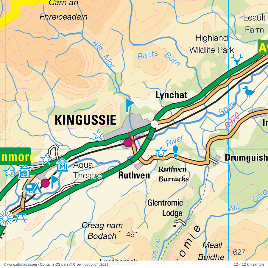
Explore the full 60 × 60 km Kingussie regional road map at 1:250,000, covering Kingussie, Aviemore, Newtonmore, Lynchat, Ruthven. Compare the complete coverage below; a detailed PDF sample is available free.

KINGUSSIE & SURROUNDING AREAREGIONAL ROAD MAP
60 × 60 km · Full map previewDownload the free SVG ↓

INSIDE THE FULL 60 × 60 KM MAP

Explore the Kingussie map area

1:250,000 cartography

Towns, villages & places

  • Kingussie
  • Aviemore
  • Newtonmore
  • Lynchat
  • Ruthven
  • Kincraig
  • Insh
  • Drumguish
  • Speybank
  • Alvie
  • Feshiebridge
  • Balgowan
  • Etteridge
  • Laggan
  • Catlodge
  • Croachy
  • Errogie
  • Gorthleck
More mapped places (39)
  • Crathie
  • Lochgarthside
  • Inverdruie
  • Ault-na-goire
  • Slochd
  • Findhornbridge
  • Avielochan
  • Coylumbridge
  • Torness
  • Tomatin
  • Whitebridge
  • Inverfarigaig
  • Foyers
  • Kinveachy
  • Farr
  • Moy
  • Lochanhully
  • Strone
  • Alltsigh
  • Drumuillie
  • Dores
  • Lewiston
  • Duthil
  • Drumnadrochit
  • Portclair
  • Invermoriston
  • Milton
  • Cullachie
  • Abriachan
  • Daviot
  • Achnaconeran
  • Lochend
  • Levishie
  • Balnain
  • Balbeg
  • Braefield
  • Shenval
  • Eskadale
  • Struy

Roads across this sheet

A95, A831, A833, A938, A939, B851, B852, B861, B862, B970, B9007, B9150, B9152, B9153, B9154

Rivers & waterways

Aberchalder Burn, Abhainn Cro Chlach, Abhainn Ghuilbinn, Allt Ballach, Allt Bhran, Allt Cam Ban, Allt Chomhraig, Allt Coire Iain Oig, Allt Crunachdain, Allt Cuaich, Allt Doe, Allt Garbh Buidhe

More waterways

Allt Gharbh Ghaig, Allt Lorgy, Allt Madagain, Allt Mor, Allt Odhar, Allt Ruadh, Allt Uisg an t-Sidhein, Bruar Water, Bynack Burn, Caledonian Canal, Crom Allt, Duthil Burn, Elrick Burn, Feith Talagain, Funtack Burn, Geldie Burn, Leonach Burn, Moy Burn, Raitts Burn, Rhilean Burn, River Affric, River Beauly, River Calder, River Coiltie, River Dee, River Druie, River Dulnain, River E, River Eidart, River Enrick, River Eskin, River Farigaig, River Farrar, River Fechlin, River Feshie, River Findhorn, River Foyers, River Glass, River Killin, River Luineag, River Mashie, River Moriston, River Nairn, River Ness, River Nethy, River Pattack, River Roy, River Spey, River Tarff, River Tromie, River Truim, Tarf Water, Tomlachlan Burn

Landmarks & landscape

Aberarder House, Aberarder Lodge, Abriachan Gardens and Nursery, Alvie Estates, Auchgourish Gardens and Arboretum, Aviemore Offroad Centre, Caiplich Prehistoric Settlement and Field System, Cairngorm Brewery, Cairngorm Reindeer Centre, Clan MacPherson Museum, Clay Pigeon Shooting, Cluny Castle, CAIRNGORMS NATIONAL PARK

More named features

Coignafearn Lodge, Corriegarth Lodge, Craft Centre, Craigellachie National Nature Reserve, Creag Meagaidh National Nature Reserve, Croila Trekking Centre, The Wildcat Centre, Crubenmore Lodge, Dalmigavie Lodge, Dalwhinnie Distillery, Divach Falls, Dochfour Gardens, Dochfour House, Drynachan Lodge, Duke of Gordon's Monument and Duchess of Gordon's Monument (2 monuments), Dunmaglass Lodge, Experience 4X4, Farr House, Gaick Lodge, Garrogie Lodge, Glenbrein Lodge, Glenfeshie Lodge, Glenmore Lodge, Glenmore Visitor Centre, Glenshero Lodge, Glentromie Lodge, Glentruim House, Highland Wildlife Park, Insh Marshes Nature Reserve, Invereshie House, Inverpattack Lodge, Iona Gallery, Killin Lodge, Knockie Lodge, Kyllachy House, Landmark Forest Theme Park, Leault Farm, Loch Garten Osprey Centre, Loch Ness Centre, The Original Loch Ness Visitor Centre, Loch Ness Clayworks, Loch Ruthven Nature Reserve, Loch an Eilein Visitor Centre, Lochindorb Lodge, Lower Fall, Lynaberack Lodge, Moy Hall, Moy Lodge, Rothiemurchus Estate Visitor Centre, Free Zone Activity Centre, Ruthven Barracks, Santa Claus Land (Theme Park) and Craft Village, Speyside Heather Centre, Statue, Strathmashie House, Strathspey Railway, The Highland Folk Museum, Tomatin Distillery, Tomatin Distillery Visitor Centre, Urquhart Castle, Visitor Centre, Waltzing Waters Aqua Theatre, Waterfalls
Local authority & parish coverage

Wholly or partly within the full map rectangle. These boundaries are coverage information, not additional artwork layers.

  • AberdeenshirePartly within
  • HighlandPartly within
  • MorayPartly within
  • Perth and KinrossPartly within
Wards & electoral divisions 11 areas
  • Aboyne, Upper Deeside and Donside Ward (part)
  • Aird and Loch Ness Ward (part)
  • Badenoch and Strathspey Ward (part)
  • Blairgowrie and Glens Ward (part)
  • Caol and Mallaig Ward (part)
  • Forres Ward (part)
  • Highland Ward (part)
  • Inverness Ness-side Ward (part)
  • Inverness South Ward (part)
  • Nairn and Cawdor Ward (part)
  • Speyside Glenlivet Ward (part)
Civil parishes & communities 0 areas

    Source: the GBMaps road atlas, OS Boundary-Line and postcode mapping datasets. Source editions are being checked for publication. Unmarked boundary names are wholly within the sheet; “part” means the map edge crosses the area.

    Place lists are selected from the map source, not a complete gazetteer. Named features describe the cartography; visitor facilities and opening status are not verified. The free sample covers only 12 × 12 km of this larger sheet.

    INSIDE YOUR DOWNLOAD

    A proper road map, in useful formats

    Road classifications, towns and villages, railways, rivers, landscape detail and tourist symbols, brought together in the GBMaps regional road atlas style.

    PDF filePDFSVG fileSVGAdobe Illustrator AI fileAi

    PDF for the finished map. SVG and layered Illustrator artwork for adapting colours, adding your own information and preparing designs.

    THE FINISHED SHEET

    Designed for print and presentation

    Map coverage
    60 × 60 km
    Sample coverage
    12 × 12 km
    Print layout
    A3 landscape · enlarged 1:250k cartography
    Sheet furniture
    Border, scale bar, key & north arrow

    A few useful details

    What changes when I select another square?

    Select a surrounding square to bring it into the centre and reveal the maps around it. Each square is a different 60 × 60 km map. The preview, free sample and selected download change together. Neighbouring sheets overlap by 30 km so you can choose the coverage that suits you.

    Is the free sample a vector map?

    The on-page detail is an SVG. The free download is a separate 12 × 12 km PDF with a link to the full map. Please retain its copyright credits and product link when sharing it.

    Can I buy a larger combined map?

    These downloads are individual ready-made sheets. Contact GBMaps if you need a larger combined area.

    FREE PDF SAMPLE

    Your free map sample

    Your free 12 × 12 km sample includes a link back to this map, so you can return for the full area whenever you need it.

    Download free PDF sample ↓

    Get your Kingussie map

    Map download bundle

    £24.00including VATOne payment

    Pay securely

    One payment. Your map stays open.

    Your map download

    Your map files

    Preparing your download…

    Checking your private download link…

    Your map downloads

    Already bought a map?

    Find the downloads from your purchases.

    Enter the email address you used at checkout. We’ll email you a private link to your available map downloads.