Inverness regional road map. Full 60 × 60 km PDF, SVG and Illustrator files, with a free PDF sample.

GBMAPS.COM

Inverness Regional Road Map

Call Us Now for Help01751 473136

GREAT BRITAIN ROAD ATLAS · 1:250,000 GB-270-0840

Inverness & surrounding area

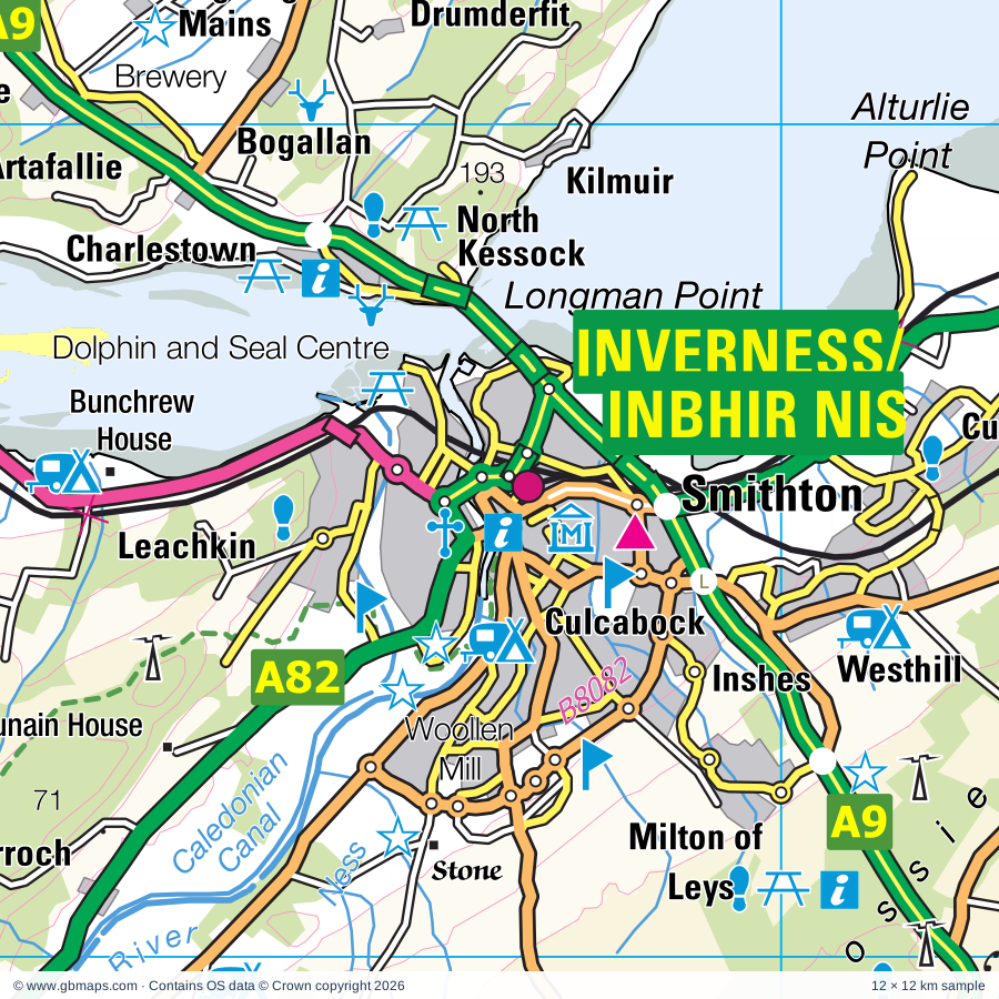
Explore the full 60 × 60 km Inverness regional road map at 1:250,000, covering Inbhir Nis, Fortrose, Dingwall, Invergordon, Aviemore. Compare the complete coverage below; a detailed PDF sample is available free.

INVERNESS & SURROUNDING AREAREGIONAL ROAD MAP
60 × 60 km · Full map previewDownload the free SVG ↓

INSIDE THE FULL 60 × 60 KM MAP

Explore the Inverness map area

1:250,000 cartography

Towns, villages & places

More mapped places (104)
  • Arpafeelie
  • Croy
  • Drumchardine
  • Tomatin
  • Munlochy
  • Redcastle
  • Avoch
  • Abriachan
  • Milton
  • Kirkhill
  • Tore
  • Clephanton
  • Findhornbridge
  • Achindown
  • Lochside
  • Kilcoy
  • Balchraggan
  • Ardersier
  • Torness
  • Cawdor
  • Knockbain
  • Rosemarkie
  • Killen
  • Beauly
  • Windhill
  • Culcharry
  • Raddery
  • Rheindown
  • Kiltarlity
  • Piperhill
  • Balvaird
  • Duncanston
  • Ruilick
  • Strone
  • Ardnagrask
  • Kilmorack
  • Moss-side
  • Culbokie
  • Corntown
  • Culburnie
  • Drumnadrochit
  • Regoul
  • Lewiston
  • Alcaig
  • Errogie
  • Slochd
  • Urray
  • Culbo
  • Milton
  • Maryburgh
  • Ault-na-goire
  • Crask of Aigas
  • Breakachy
  • Littlemill
  • Inverfarigaig
  • Eskadale
  • Davidston
  • Redburn
  • Mountgerald
  • Jemimaville
  • Resolis
  • Marybank
  • Balbeg
  • Kingsteps
  • Balblair
  • Gorthleck
  • Ferness
  • Auldearn
  • Fodderty
  • Foyers
  • Balnain
  • Lochanhully
  • Lochgarthside
  • Evanton
  • Jamestown
  • Duthil
  • Strathpeffer
  • Swordale
  • Achterneed
  • Bottacks
  • Dalmore
  • Contin
  • Struy
  • Kinveachy
  • Nigg Ferry
  • Braefield
  • Shenval
  • Avielochan
  • Whitemire
  • Drumuillie
  • Alltsigh
  • Conicavel
  • Brodie
  • Whitebridge
  • Tarvie
  • Cullachie
  • Dyke
  • Cloddymoss
  • Inverdruie
  • Achnaconeran
  • Coylumbridge
  • Invermoriston
  • Levishie
  • Portclair

Roads across this sheet

A95, A831, A832, A833, A834, A862, A938, A939, B817, B851, B852, B853, B861, B862, B865, B970, B8082, B9006, B9007, B9039, B9090, B9091, B9092, B9101

More road numbers

B9111, B9152, B9153, B9154, B9160, B9161, B9162, B9163, B9164, B9169, B9175, B9176, B9177

Rivers & waterways

Aberchalder Burn, Abhainn Cro Chlach, Allt Dearg, Allt Goibhre, Allt Lorgy, Allt Uisg an t-Sidhein, Allt nan Caorach, Black Water, Caledonian Canal, Dorback Burn, Duthil Burn, Elrick Burn

More waterways

Funtack Burn, Leonach Burn, Moy Burn, Muckle Burn, Rhilean Burn, Riereach Burn, River Affric, River Averon or Alness River, River Beauly, River Coiltie, River Conon, River Druie, River Dulnain, River E, River Enrick, River Eskin, River Farigaig, River Farrar, River Fechlin, River Findhorn, River Foyers, River Glass, River Luineag, River Moriston, River Nairn, River Ness, River Nethy, River Orrin, River Sgitheach, River Spey, Tomlachlan Burn

Landmarks & landscape

Aberarder House, Abriachan Gardens and Nursery, Aigas Dam Fish Pass, Ardclach Bell Tower, Assynt House, Auchgourish Gardens and Arboretum, Aviemore Offroad Centre, Beaufort Castle, Beauly Priory, Ben M Nature Reserve, Black Isle Brewery, Black Isle Wildlife and Country Park, CAIRNGORMS NATIONAL PARK

More named features

Black Rock Gorge, Bogbain Adventure and Heritage Farm, Brodie Castle, Bunchrew House, Caiplich Prehistoric Settlement and Field System, Cairngorm Brewery, Castle, Castle Leod, Castle Stuart, Cawder Castle, Cawdor Castle and Gardens, Clanland and Seal Point Visitor Centre, Clava Cairns, Clay Pigeon Shooting, Coignafearn Lodge, Conon House, Corriegarth Lodge, Craigellachie National Nature Reserve, Croft 7, Cromarty Courthouse Museum, Culbin Forest Nature Reserve, Culloden Battlefield Visitor Centre, Cycle Trail, Dalmigavie Lodge, Dalmore Distillery, Dingwall Town House Museum, Divach Falls, Dochfour Gardens, Dochfour House, Driftwater Weavers, Drynachan Lodge, Dunain House, Dunmaglass Lodge, Eileanach Lodge, Experience 4X4, Farr House, Floral Hall and Visitor Centre, Fort George, Fortrose Cathedral, Foulis Castle, Garrogie Lodge, Geddes House, Glen Ord Distillery, Glenbrein Lodge, Glenferness House, Groam House Museum, Highland Museum of Childhood, Holm Woollen Mill, House of Daviot, Hugh Miller's Cottage, Inchbae Lodge, Invergordon Heritage Centre, Inverness Museum and Art Gallery, Balnain House Museum, Kilravock Castle, Knockagael Boar Stone, Knockie Lodge, Kyllachy House, Landmark Forest Theme Park, Lentran House, Loch Garten Osprey Centre, Loch Ness Centre, The Original Loch Ness Visitor Centre, Loch Ness Clayworks, Loch Ruthven Nature Reserve, Lochindorb Lodge, Lower Fall, McFarquhar's Cave, Moniack Castle, Monument, Motte and Dovecot, Moy Hall, Nature Reserve, Newhall House, Northern Lights Candle Workshop, Other Tourist Attraction, Patchris Corner, Randolph's Leap, Rogie Falls, Roskill House, Rothiemurchus Estate Visitor Centre, Free Zone Activity Centre, Royal Brackla Distillery, Santa Claus Land (Theme Park) and Craft Village, Seaforth Highland Country Estate, Speyside Heather Centre, St Andrews Cathedral, Strathspey Railway, The Highlanders Regimental Museum, The Nairn Museum, Piccolo Printing Museum, Tollie Red Kites, Tomatin Distillery, Tomatin Distillery Visitor Centre, Touchstone Maze, Tower, Urquhart Castle, Visitor Centre, WDCS Dolphin and Seal Centre, Wardlaw Mausoleum, Waterfalls
Local authority & parish coverage

Wholly or partly within the full map rectangle. These boundaries are coverage information, not additional artwork layers.

  • HighlandPartly within
  • MorayPartly within
Wards & electoral divisions 15 areas
  • Aird and Loch Ness Ward (part)
  • Badenoch and Strathspey Ward (part)
  • Black Isle Ward
  • Cromarty Firth Ward (part)
  • Culloden and Ardersier Ward
  • Dingwall and Seaforth Ward
  • Forres Ward (part)
  • Inverness Central Ward
  • Inverness Millburn Ward
  • Inverness Ness-side Ward
  • Inverness South Ward (part)
  • Inverness West Ward
  • Nairn and Cawdor Ward (part)
  • Tain and Easter Ross Ward (part)
  • Wester Ross, Strathpeffer and Lochalsh Ward (part)
Civil parishes & communities 0 areas

    Source: the GBMaps road atlas, OS Boundary-Line and postcode mapping datasets. Source editions are being checked for publication. Unmarked boundary names are wholly within the sheet; “part” means the map edge crosses the area.

    Place lists are selected from the map source, not a complete gazetteer. Named features describe the cartography; visitor facilities and opening status are not verified. The free sample covers only 12 × 12 km of this larger sheet.

    INSIDE YOUR DOWNLOAD

    A proper road map, in useful formats

    Road classifications, towns and villages, railways, rivers, landscape detail and tourist symbols, brought together in the GBMaps regional road atlas style.

    PDF filePDFSVG fileSVGAdobe Illustrator AI fileAi

    PDF for the finished map. SVG and layered Illustrator artwork for adapting colours, adding your own information and preparing designs.

    THE FINISHED SHEET

    Designed for print and presentation

    Map coverage
    60 × 60 km
    Sample coverage
    12 × 12 km
    Print layout
    A3 landscape · enlarged 1:250k cartography
    Sheet furniture
    Border, scale bar, key & north arrow

    A few useful details

    What changes when I select another square?

    Select a surrounding square to bring it into the centre and reveal the maps around it. Each square is a different 60 × 60 km map. The preview, free sample and selected download change together. Neighbouring sheets overlap by 30 km so you can choose the coverage that suits you.

    Is the free sample a vector map?

    The on-page detail is an SVG. The free download is a separate 12 × 12 km PDF with a link to the full map. Please retain its copyright credits and product link when sharing it.

    Can I buy a larger combined map?

    These downloads are individual ready-made sheets. Contact GBMaps if you need a larger combined area.

    FREE PDF SAMPLE

    Your free map sample

    Your free 12 × 12 km sample includes a link back to this map, so you can return for the full area whenever you need it.

    Download free PDF sample ↓

    Get your Inverness map

    Map download bundle

    £24.00including VATOne payment

    Pay securely

    One payment. Your map stays open.

    Your map download

    Your map files

    Preparing your download…

    Checking your private download link…

    Your map downloads

    Already bought a map?

    Find the downloads from your purchases.

    Enter the email address you used at checkout. We’ll email you a private link to your available map downloads.