Ilminster regional road map. Full 60 × 60 km PDF, SVG and Illustrator files, with a free PDF sample.

GBMAPS.COM

Ilminster Regional Road Map

Call Us Now for Help01751 473136

GREAT BRITAIN ROAD ATLAS · 1:250,000 GB-330-0120

Ilminster & surrounding area

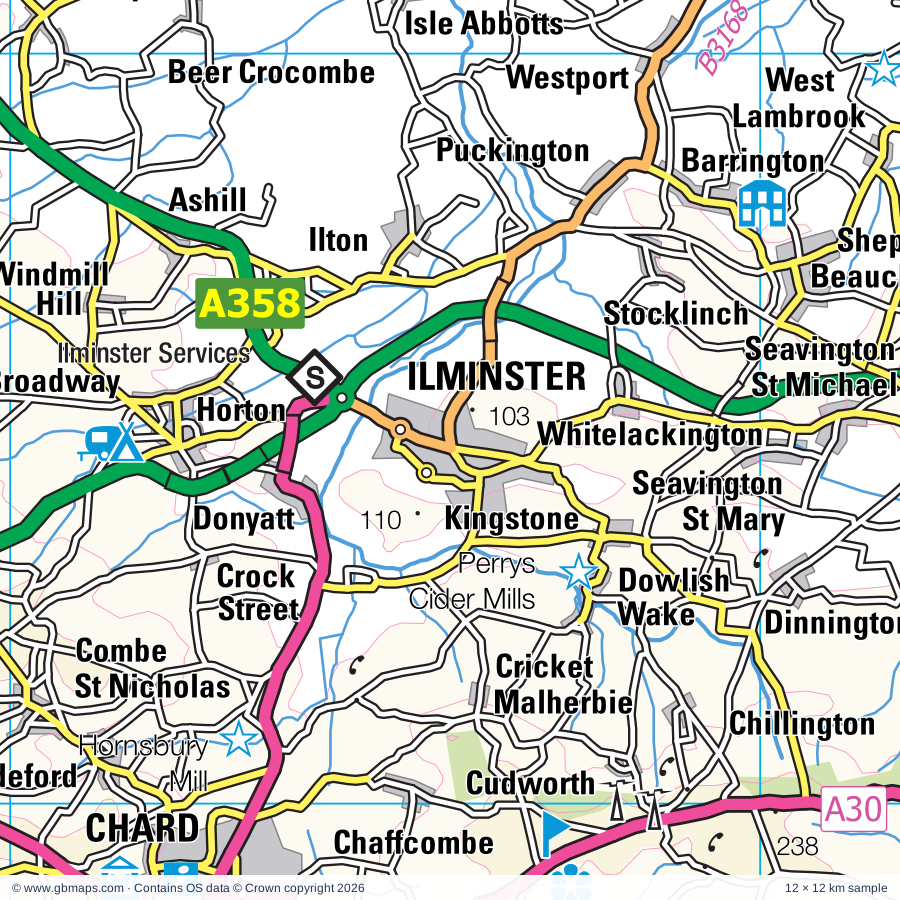
Explore the full 60 × 60 km Ilminster regional road map at 1:250,000, covering Wells, Ilminster, Taunton, Chard, Langport. Compare the complete coverage below; a detailed PDF sample is available free.

ILMINSTER & SURROUNDING AREAREGIONAL ROAD MAP
60 × 60 km · Full map previewDownload the free SVG ↓

INSIDE THE FULL 60 × 60 KM MAP

Explore the Ilminster map area

1:250,000 cartography

Towns, villages & places

More mapped places (367)
  • Cullompton
  • Bridport
  • Watchet
  • Bickenhall
  • Beercrocombe
  • Wrantage
  • Curland
  • Ashill
  • Thurlbear
  • Thornfalcon
  • Broadway
  • Isle Abbotts
  • Ham
  • Knapp
  • Horton
  • Ilton
  • Fivehead
  • Ruishton
  • Corfe
  • Donyatt
  • Bathpool
  • Swell
  • Puckington
  • Pitminster
  • Durston
  • West Lyng
  • Bishopswood
  • Westport
  • Stocklinch
  • Trull
  • Fyfett
  • Lyng
  • Barrington
  • Whitelackington
  • Hedging
  • Hambridge
  • East Lyng
  • Wadeford
  • Whitestaunton
  • Kingstone
  • Thurloxton
  • Athelney
  • Angersleigh
  • Marsh
  • Staplegrove
  • Howley
  • Chaffcombe
  • Rumwell
  • Churchinford
  • Drayton
  • Stathe
  • Churchstanton
  • Burrowbridge
  • Wambrook
  • Cudworth
  • Dinnington
  • Stembridge
  • Chillington
  • Northmoor Green
  • Stapley
  • Yarcombe
  • Fulford
  • Newcott
  • Allerford
  • Pathe
  • Blackmoor
  • Forton
  • Aller
  • Lopen
  • Muchelney
  • Pickney
  • Broomfield
  • Othery
  • Hillfarrance
  • Cushuish
  • Huntworth
  • Ford Street
  • Clayhidon
  • Goathurst
  • Middlezoy
  • Cotford St Luke
  • Wearne
  • Heathfield
  • Coat
  • Winsham
  • Westonzoyland
  • Oake
  • Upottery
  • Chardstock
  • Furley
  • Low Ham
  • Enmore
  • Merriott
  • Nynehead
  • Durleigh
  • Martock
  • Stockland
  • Stapleton
  • Cothelstone
  • Rawridge
  • Tytherleigh
  • High Ham
  • Long Load
  • Hewish
  • Membury
  • Courtway
  • Pitney
  • Wayford
  • Ash
  • Hemyock
  • Long Sutton
  • Chiselborough
  • Clapton
  • Wembdon
  • Halse
  • Wrangway
  • Holditch
  • Westford
  • Witcombe
  • Chedzoy
  • Churchill
  • Henley
  • Thorncombe
  • Abbey
  • Runnington
  • Spaxton
  • Charlynch
  • Luppitt
  • Milverton
  • Beacon
  • Smallridge
  • Seaborough
  • Drimpton
  • Aisholt
  • Moorlinch
  • Stawell
  • Misterton
  • Blackdown
  • Fitzhead
  • Montacute
  • Hawkchurch
  • Tintinhull
  • Dunkeswell
  • Dalwood
  • Greinton
  • Monkton
  • Cannington
  • Bawdrip
  • Nicholashayne
  • Cotleigh
  • Culmstock
  • Pedwell
  • Dunball
  • Birdsmoorgate
  • Odcombe
  • Cossington
  • Burstock
  • Sheldon
  • Catcott
  • Mosterton
  • Ashcott
  • Edington
  • Shapwick
  • Puriton
  • Marshwood
  • Dundon
  • Marshalsea
  • Flaxpool
  • Littleton
  • Tarr
  • Wilmington
  • Kilmington
  • Woolavington
  • Fiddington
  • Broadwindsor
  • Widworthy
  • Ilchester
  • Bathealton
  • Kingsdon
  • Bettiscombe
  • Pitsford Hill
  • Coultings
  • Craddock
  • Combwich
  • Burlescombe
  • Pawlett
  • Appley
  • Walton
  • Offwell
  • Shute
  • Ashill
  • Crowcombe
  • Blackborough
  • Tolland
  • Pilsdon
  • Langley
  • Chedington
  • Willett
  • Otterhampton
  • Appledore
  • Stretcholt
  • Pendomer
  • Limington
  • Westleigh
  • Uffculme
  • Whitford
  • Awliscombe
  • Yeovilton
  • Ashbrittle
  • Stogursey
  • Broadhembury
  • Burtle
  • Smithincott
  • Podimore
  • Kingweston
  • Musbury
  • Waterrow
  • Holford
  • Maundown
  • East Huntspill
  • Huntspill
  • Stringston
  • Butleigh
  • Westhay
  • Steart
  • Shurton
  • Kerswell
  • Northleigh
  • Hockworthy
  • Ashington
  • Kentisbeare
  • Burton
  • Elworthy
  • Bason Bridge
  • Buckerell
  • Corscombe
  • Bridgehampton
  • Stolford
  • Meare
  • Stogumber
  • Chipstable
  • Uplyme
  • Barwick
  • Alstone
  • Dulford
  • Netherbury
  • Clatworthy
  • Farway
  • Bicknoller
  • Charmouth
  • Gittisham
  • Broadoak
  • Ryall
  • Mudford
  • Highbridge
  • Watchfield
  • Lower Cheriton
  • Stoford
  • Kilton
  • Kilve
  • Whitnage
  • Babcary
  • Combpyne
  • Vellow
  • Morcombelake
  • Higher Cheriton
  • Salway Ash
  • Colyford
  • Willand
  • Clayhanger
  • Closworth
  • Southleigh
  • Waytown
  • Payhembury
  • Edgarley
  • Lilstock
  • Westham
  • Mapperton
  • Rousdon
  • Monksilver
  • Baltonsborough
  • Alfington
  • Uplowman
  • Feniton
  • Melplash
  • Mark
  • Southwood
  • Godney
  • Axmouth
  • Edithmead
  • Dottery
  • Trent
  • Mudgley
  • Blackford
  • Petton
  • Adber
  • Chideock
  • Huntsham
  • Symondsbury
  • Plymtree
  • Seatown
  • Halberton
  • Williton
  • Yetminster
  • Hooke
  • Theale
  • Talaton
  • Southway
  • Mutterton
  • Wedmore
  • Fairmile
  • Polsham
  • West Bradley
  • Bradpole
  • Parbrook
  • Rampisham
  • Evershot
  • Lovington
  • Higher Kingcombe
  • Henton
  • Westcott
  • Powerstock
  • Yarley
  • Hornblotton
  • Langford
  • Loders
  • Colebrook
  • Roadwater
  • Coxley
  • Cocklake
  • Sidbury
  • Nettlecombe
  • Harcombe
  • Walditch
  • Washford
  • Wiggaton
  • Wraxall
  • Holywell
  • Treborough
  • Uploders
  • Bilbrook
  • Wookey
  • Whimple
  • Shipton Gorge
  • Rodhuish
  • Easton
  • Chalmington
  • Metcombe
  • Westwood
  • Withycombe
  • Cattistock
  • Askerswell
  • Worminster
  • Chilfrome
  • Pilton
  • Dulcote
  • Blue Anchor
  • Harpford
  • Carhampton
  • Chilcombe
  • Dinder
  • Southerton
  • Rockbeare
  • Croscombe
  • Aylesbeare
  • Cranbrook
  • Farringdon

Roads across this sheet

M5, A30, A35, A37, A38, A39, A356, A358, A359, A361, A371, A372, A373, A375, A378, A3027, A3038, A3052, A3055, A3066, A3087, A3088, A3259, A3807

More road numbers

B3135, B3139, B3140, B3141, B3148, B3151, B3153, B3157, B3161, B3162, B3163, B3164, B3165, B3167, B3168, B3170, B3172, B3174, B3177, B3180, B3181, B3184, B3187, B3188, B3190, B3191, B3224, B3227, B3261, B3339, B3391, B3440

Rivers & waterways

Bridgwater & Taunton Canal, Grand Western Canal, River Axe, River Brit, River Brue, River Cary, River Char, River Clyst, River Culm, River Frome, River Isle, River Otter

More waterways

River Parrett, River Tale, River Tone, River Yarty, River Yeo, Westport Canal (disused), Whitelake

Landmarks & landscape

Abbot's Fish House, Ark Pottery, Ashton Windmill, Avalon Vineyard, Axminster Museum, Ayshford Solar Farm, Barrington Court, Beaminster Museum, Bishop's Palace, Blackbury Camp, Bridport Museum, Broadclyst Energy Farm, EXMOOR NATIONAL PARK

More named features

Burcot Mill, Burrow Farm Gardens, Cadhay House, Chalice Well Gardens, Clapton Watermill, Cleeve Abbey, Coldharbour Mill, Coleridge Cottage, Combe Sydenham Country Park, Cothay Manor, Coxley Vineyard, Crealy Adventure Park, Cricket St Thomas, Cricket St Thomas Lake & Gardens, Daws Castle, Diggerland, Eggardon Rare Breeds Hill Barn Farm, Eles Family Pottery, Escot House and Gardens, Ferne Animal Sanctuary, Fleet Air Arm Museum, Forde Abbey, Forde Abbey and Gardens, Fyne Court Nature Reserve & Visitor Centre, Glastonbury Abbey, Glastonbury Tor-Chalice Well, Glastonbury Tribunal, Grand Western Canal Country Park, Ham Hill Country Park, Hestercombe House Gardens, Holbrook Garden, Honiton Museum, Allhallows Museum of Lace and Local Antiquities, Hornsbury Mill, Hornsbury Mill Museum, Chard Museum, Ilchester Town Museum, Jurassic Coast (World Heritage Site), Langmoor Gardens, Langport & River Parrett Visitor Centre, Llama Trekking, London Cigarette Card Museum, Lower Severalls Garden, Lyme Regis Museum, Lyte's Cary Manor, Mangerton Watermill, Mapperton Gardens, Margery Fish Gardens, Maunsel Canal Centre, Milton Lodge Garden, Montacute House, Montacute TV and Radio Museum, Monument, Moores Dorset Biscuits, Moorlynch Vineyard Crafts, Muchelney Abbey, National Animal Welfare Trust, Otterhead Lakes Nature Reserve, Palmers Brewery Tour, Perrys Cider Mills, Pilton Manor Vineyard, Priest's House, Rich's Farmhouse Cider Farm, Sand, Seaton and District Electric Tramway, Secret World of Wildlife, Sheppy's Cider Farm Centre, Shute Barton, Smeatharpe Stadium, Solar Farm, Somerset Brick and Tile Museum, Admiral Blake Museum, Somerset Cricket Museum, Museum of Somerset, Somerset Guild of Craftsmen, Somerset Rural Life Museum, St Marys Church, Stembridge Tower Mill, Stockland Great Castle, Stoke Sub Hamdon Priory, Taunton Racecourse, Temple of Harmony, The Bakelite Museum, The Gauge Museum, The Marine Aquarium and Cobb History, The Shoe Museum, The Somerset Cider Brandy & Burrow Hill Cider, The Walled Gardens of Cannington, Tintinhull House Gardens, Torre Cider Farm, Town Mill, Treasurer's house, Tropiquaria Wildlife Park, Vellow Pottery, Vigo Wood Nature Reserve, Watchet Boat Museum, The Market House Museum, Wellington Museum, Wellington Park Botanical Gardens, Wells Cathedral, Wells Museum, West Coker Nature Reserve, West Sedgemoor Nature Reserve, West Somerset Railway, West Somerset Railway Museum, Westhay Moor Nature Reserve, Westonzoyland Pumping Station Museum, Willows & Wetlands Visitor Centre, Winterbourne Poor Lot Barrows, Wookey Hole Papermill, Yandles, Yeovil Community Arts Centre, Yeovil County Showground
Local authority & parish coverage

Wholly or partly within the full map rectangle. These boundaries are coverage information, not additional artwork layers.

  • DorsetPartly within
  • East Devon DistrictPartly within
  • Mid Devon DistrictPartly within
  • SomersetPartly within
Wards & electoral divisions 90 areas
  • Axminster Ward
  • Beaminster Ward
  • Beer & Branscombe Ward (part)
  • Bradninch Ward (part)
  • Bridport Ward
  • Broadclyst Ward (part)
  • Budleigh & Raleigh Ward (part)
  • Canonsleigh Ward (part)
  • Chesil Bank Ward (part)
  • Clare & Shuttern Ward (part)
  • Clyst Valley Ward (part)
  • Coly Valley Ward
  • Cranbrook Ward (part)
  • Cullompton Padbrook Ward (part)
  • Cullompton St. Andrews Ward
  • Cullompton Vale Ward (part)
  • Dunkeswell & Otterhead Ward
  • Eggardon Ward (part)
  • Feniton Ward
  • Halberton Ward (part)
  • Honiton St. Michael's Ward
  • Honiton St. Paul's Ward
  • Lower Culm Ward
  • Lyme & Charmouth Ward
  • Marshwood Vale Ward
  • Newbridges Ward
  • Newton Poppleford & Harpford Ward (part)
  • Ottery St. Mary Ward
  • Seaton Ward (part)
  • Sherborne Rural Ward (part)
  • Sidmouth Rural Ward (part)
  • Sidmouth Sidford Ward (part)
  • Tale Vale Ward
  • Tiverton Lowman Ward (part)
  • Trinity Ward (part)
  • Upper Culm Ward
  • West Hill & Aylesbeare Ward (part)
  • Whimple & Rockbeare Ward
  • Winterborne & Broadmayne Ward (part)
  • Woodbury & Lympstone Ward (part)
  • Yarty Ward
  • Yetminster Ward (part)
  • Bishop's Hull & Taunton West ED
  • Blackdown & Neroche ED
  • Brent ED (part)
  • Bridgwater East & Bawdrip ED
  • Bridgwater North & Central ED
  • Bridgwater South ED
  • Bridgwater West ED
  • Brympton ED
  • Burnham on Sea North ED (part)
  • Cannington ED (part)
  • Castle Cary ED (part)
  • Chard North ED
  • Chard South ED
  • Cheddar ED (part)
  • Coker ED
  • Comeytrowe & Trull ED
  • Crewkerne ED
  • Curry Rivel & Langport ED
  • Dulverton & Exmoor ED (part)
  • Dunster ED (part)
  • Glastonbury ED
  • Highbridge & Burnham South ED
  • Huntspill ED
  • Ilminster ED
  • King Alfred ED (part)
  • Lydeard ED
  • Martock ED
  • Mendip Hills ED (part)
  • Mendip South ED (part)
  • Mendip West ED (part)
  • Monkton & North Curry ED
  • North Petherton ED
  • Rowbarton & Staplegrove ED
  • Shepton Mallet ED (part)
  • Somerton ED
  • South Petherton & Islemoor ED
  • Street ED
  • Taunton East ED
  • Taunton North ED
  • Taunton South ED
  • Upper Tone ED
  • Watchet & Stogursey ED
  • Wellington ED
  • Wells ED
  • Yeovil Central ED
  • Yeovil East ED
  • Yeovil South ED
  • Yeovil West ED
Civil parishes & communities 387 areas
  • Alford CP (part)
  • All Saints CP
  • Aller CP
  • Ash CP
  • Ash Priors CP
  • Ashbrittle CP
  • Ashcott CP
  • Ashill CP
  • Askerswell CP
  • Awliscombe CP
  • Axminster CP
  • Axmouth CP (part)
  • Aylesbeare CP (part)
  • Babcary CP
  • Badgworth CP (part)
  • Baltonsborough CP
  • Bampton CP (part)
  • Barrington CP
  • Barton St. David CP
  • Barwick and Stoford CP
  • Bathealton CP
  • Bawdrip CP
  • Beaminster CP
  • Beer CP (part)
  • Beer Hackett CP (part)
  • Beercrocombe CP
  • Bettiscombe CP
  • Bickenhall CP
  • Bicknoller CP
  • Bishop's Hull CP
  • Bishop's Lydeard CP
  • Bradford Abbas CP
  • Bradford-on-Tone CP
  • Bradninch CP (part)
  • Branscombe CP (part)
  • Brent Knoll CP (part)
  • Bridgwater CP
  • Bridgwater Without CP
  • Bridport CP
  • Broad Clyst CP (part)
  • Broadhembury CP
  • Broadway CP
  • Broadwindsor CP
  • Brompton Ralph CP
  • Brompton Regis CP (part)
  • Broomfield CP
  • Brympton CP
  • Buckerell CP
  • Buckland St. Mary CP
  • Burlescombe CP
  • Burnham Without CP (part)
  • Burnham-on-Sea and Highbridge CP (part)
  • Burrowbridge CP
  • Burstock CP
  • Burtle CP
  • Burton Bradstock CP (part)
  • Butleigh CP
  • Cannington CP
  • Carhampton CP (part)
  • Castleton CP (part)
  • Catcott CP
  • Catherston Leweston CP
  • Cattistock CP (part)
  • Chaffcombe CP
  • Chapel Allerton CP (part)
  • Chard Town CP
  • Chardstock CP
  • Charmouth CP
  • Cheddar CP (part)
  • Cheddon Fitzpaine CP
  • Chedington CP
  • Chedzoy CP
  • Chetnole CP (part)
  • Chewton Mendip CP (part)
  • Chideock CP
  • Chilcombe CP (part)
  • Chilfrome CP
  • Chillington CP
  • Chilthorne Domer CP
  • Chilton Cantelo CP
  • Chilton Polden CP
  • Chilton Trinity CP
  • Chipstable CP
  • Chiselborough CP
  • Churchstanton CP
  • Clatworthy CP
  • Clayhanger CP
  • Clayhidon CP
  • Clifton Maybank CP
  • Closworth CP
  • Clyst Honiton CP (part)
  • Clyst Hydon CP
  • Clyst St. Lawrence CP
  • Clyst St. Mary CP (part)
  • Colaton Raleigh CP (part)
  • Colyford CP
  • Colyton CP
  • Combe Florey CP
  • Combe Raleigh CP
  • Combe St. Nicholas CP
  • Combpyne Rousdon CP (part)
  • Compton Dundon CP
  • Compton Valence CP (part)
  • Corfe CP
  • Corscombe CP
  • Cossington CP
  • Cotford St. Luke CP
  • Cothelstone CP
  • Cotleigh CP
  • Cranbrook CP (part)
  • Creech St. Michael CP
  • Crewkerne CP
  • Cricket St. Thomas CP
  • Croscombe CP (part)
  • Crowcombe CP
  • Cudworth CP
  • Cullompton CP (part)
  • Culmstock CP
  • Curland CP
  • Curry Mallet CP
  • Curry Rivel CP
  • Dalwood CP
  • Dinnington CP
  • Ditcheat CP (part)
  • Donyatt CP
  • Dowlish Wake CP
  • Drayton CP
  • Dunkeswell CP
  • Dunster CP (part)
  • Durleigh CP
  • Durston CP
  • East Brent CP (part)
  • East Chelborough CP
  • East Chinnock CP
  • East Coker CP
  • East Huntspill CP
  • East Pennard CP (part)
  • East Quantoxhead CP
  • Edington CP
  • Elworthy CP
  • Emborough CP (part)
  • Enmore CP
  • Evershot CP
  • Farringdon CP (part)
  • Farway CP
  • Feniton CP
  • Fiddington CP
  • Fitzhead CP
  • Fivehead CP
  • Frome St. Quintin CP (part)
  • Frome Vauchurch CP (part)
  • Gittisham CP
  • Glastonbury CP
  • Goathurst CP
  • Godney CP
  • Greinton CP
  • Halberton CP (part)
  • Halse CP
  • Halstock CP
  • Hambridge and Westport CP
  • Hardington Mandeville CP
  • Haselbury Plucknett CP
  • Hatch Beauchamp CP
  • Hawkchurch CP
  • Hemyock CP
  • High Ham CP
  • Hinton St. George CP
  • Hockworthy CP
  • Holcombe Rogus CP
  • Holford CP
  • Honiton CP
  • Hooke CP
  • Horton CP
  • Huish Champflower CP
  • Huish Episcopi CP
  • Huntsham CP (part)
  • Ilchester CP
  • Ilminster CP
  • Ilton CP
  • Isle Abbotts CP
  • Isle Brewers CP
  • Keinton Mandeville CP
  • Kentisbeare CP
  • Kilmington CP
  • Kilve CP
  • Kingsbury Episcopi CP
  • Kingsdon CP
  • Kingston St. Mary CP
  • Kingstone CP
  • Kingweston CP
  • Knowle St. Giles CP
  • LCPs of Axminster and Kilmington
  • Langford Budville CP
  • Langport CP
  • Littlebredy CP (part)
  • Litton Cheney CP (part)
  • Loders CP
  • Long Bredy and Kingston Russell CP (part)
  • Long Load CP
  • Long Sutton CP
  • Lopen CP
  • Lovington CP (part)
  • Luppitt CP
  • Luxborough CP (part)
  • Lydeard St. Lawrence CP
  • Lydford-on-Fosse CP
  • Lyme Regis CP
  • Lyng CP
  • Maiden Newton CP (part)
  • Mapperton CP
  • Mark CP (part)
  • Marshwood CP
  • Marston Magna CP (part)
  • Martock CP
  • Meare CP
  • Melbury Bubb CP (part)
  • Melbury Osmond CP
  • Melbury Sampford CP
  • Membury CP
  • Merriott CP
  • Middlezoy CP
  • Milverton CP
  • Misterton CP
  • Monksilver CP
  • Monkton CP
  • Montacute CP
  • Moorlinch CP
  • Mosterton CP
  • Muchelney CP
  • Mudford CP
  • Musbury CP
  • Nether Compton CP (part)
  • Nether Stowey CP
  • Netherbury CP
  • Nettlecombe CP
  • Newton Poppleford and Harpford CP (part)
  • North Barrow CP (part)
  • North Curry CP
  • North Perrott CP
  • North Petherton CP
  • North Poorton CP
  • North Wootton CP
  • Northleigh CP
  • Norton Fitzwarren CP
  • Norton sub Hamdon CP
  • Nynehead CP
  • Oake CP
  • Odcombe CP
  • Offwell CP
  • Old Cleeve CP
  • Orchard Portman CP
  • Othery CP
  • Otterford CP
  • Otterhampton CP (part)
  • Ottery St. Mary CP
  • Over Compton CP
  • Over Stowey CP
  • Pawlett CP
  • Payhembury CP
  • Pilsdon CP
  • Pilton CP (part)
  • Pitminster CP
  • Pitney CP
  • Plymtree CP
  • Powerstock CP
  • Priddy CP (part)
  • Puckington CP
  • Puriton CP
  • Pylle CP (part)
  • Queen Camel CP (part)
  • Rampisham CP
  • Rimpton CP (part)
  • Rockbeare CP
  • Rodney Stoke CP (part)
  • Ruishton CP
  • Ryme Intrinseca CP
  • Sampford Arundel CP
  • Sampford Brett CP
  • Sampford Peverell CP
  • Seaborough CP
  • Seaton CP (part)
  • Seavington St. Mary CP
  • Seavington St. Michael CP
  • Shapwick CP
  • Sharpham CP
  • Sheldon CP
  • Shepton Beauchamp CP
  • Shepton Mallet CP (part)
  • Shipton Gorge CP
  • Shute CP
  • Sidmouth CP (part)
  • Skilgate CP (part)
  • Somerton CP
  • South Barrow CP (part)
  • South Perrott CP
  • South Petherton CP
  • Southleigh CP
  • Sparkford CP (part)
  • Spaxton CP
  • St. Cuthbert Out CP (part)
  • Stanton St. Gabriel CP
  • Staple Fitzpaine CP
  • Stawell CP
  • Stawley CP
  • Stockland Bristol CP
  • Stockland CP
  • Stocklinch CP
  • Stockwood CP
  • Stogumber CP
  • Stogursey CP
  • Stoke Abbott CP
  • Stoke St. Gregory CP
  • Stoke St. Mary CP
  • Stoke sub Hamdon CP
  • Street CP
  • Stringston CP
  • Swyre CP (part)
  • Symondsbury CP
  • Talaton CP
  • Tatworth and Forton CP
  • Taunton CP
  • The Charltons CP
  • Thorncombe CP
  • Thornfalcon CP
  • Thornford CP (part)
  • Thurloxton CP
  • Tintinhull CP
  • Tiverton CP (part)
  • Tolland CP
  • Toller Fratrum CP
  • Toller Porcorum CP
  • Treborough CP (part)
  • Trent CP (part)
  • Trull CP
  • Uffculme CP
  • Uplowman CP (part)
  • Uplyme CP
  • Upottery CP
  • Upton CP (part)
  • Walton CP
  • Wambrook CP
  • Watchet CP
  • Wayford CP
  • Wedmore CP (part)
  • Wellington CP
  • Wellington Without CP
  • Wells CP
  • Wembdon CP
  • West Bagborough CP
  • West Bradley CP (part)
  • West Buckland CP
  • West Camel CP
  • West Chelborough CP
  • West Coker CP
  • West Compton CP
  • West Crewkerne CP
  • West Hatch CP
  • West Hill CP
  • West Huntspill CP
  • West Monkton CP
  • West Pennard CP
  • West Quantoxhead CP
  • West and Middle Chinnock CP
  • Westbury CP (part)
  • Westonzoyland CP
  • Whimple CP
  • Whitchurch Canonicorum CP
  • Whitelackington CP
  • Whitestaunton CP
  • Widworthy CP
  • Willand CP
  • Williton CP
  • Winsham CP
  • Winterbourne Abbas CP (part)
  • Withycombe CP (part)
  • Wiveliscombe CP
  • Woodbury CP (part)
  • Wookey CP
  • Woolavington CP
  • Wootton Fitzpaine CP
  • Wraxall CP
  • Wynford Eagle CP
  • Yarcombe CP
  • Yeovil CP
  • Yeovil Without CP
  • Yeovilton and District CP
  • Yetminster CP (part)

Source: the GBMaps road atlas, OS Boundary-Line and postcode mapping datasets. Source editions are being checked for publication. Unmarked boundary names are wholly within the sheet; “part” means the map edge crosses the area.

Place lists are selected from the map source, not a complete gazetteer. Named features describe the cartography; visitor facilities and opening status are not verified. The free sample covers only 12 × 12 km of this larger sheet.

INSIDE YOUR DOWNLOAD

A proper road map, in useful formats

Road classifications, towns and villages, railways, rivers, landscape detail and tourist symbols, brought together in the GBMaps regional road atlas style.

PDF filePDFSVG fileSVGAdobe Illustrator AI fileAi

PDF for the finished map. SVG and layered Illustrator artwork for adapting colours, adding your own information and preparing designs.

THE FINISHED SHEET

Designed for print and presentation

Map coverage
60 × 60 km
Sample coverage
12 × 12 km
Print layout
A3 landscape · enlarged 1:250k cartography
Sheet furniture
Border, scale bar, key & north arrow

A few useful details

What changes when I select another square?

Select a surrounding square to bring it into the centre and reveal the maps around it. Each square is a different 60 × 60 km map. The preview, free sample and selected download change together. Neighbouring sheets overlap by 30 km so you can choose the coverage that suits you.

Is the free sample a vector map?

The on-page detail is an SVG. The free download is a separate 12 × 12 km PDF with a link to the full map. Please retain its copyright credits and product link when sharing it.

Can I buy a larger combined map?

These downloads are individual ready-made sheets. Contact GBMaps if you need a larger combined area.

FREE PDF SAMPLE

Your free map sample

Your free 12 × 12 km sample includes a link back to this map, so you can return for the full area whenever you need it.

Download free PDF sample ↓

Get your Ilminster map

Map download bundle

£24.00including VATOne payment

Pay securely

One payment. Your map stays open.

Your map download

Your map files

Preparing your download…

Checking your private download link…

Your map downloads

Already bought a map?

Find the downloads from your purchases.

Enter the email address you used at checkout. We’ll email you a private link to your available map downloads.