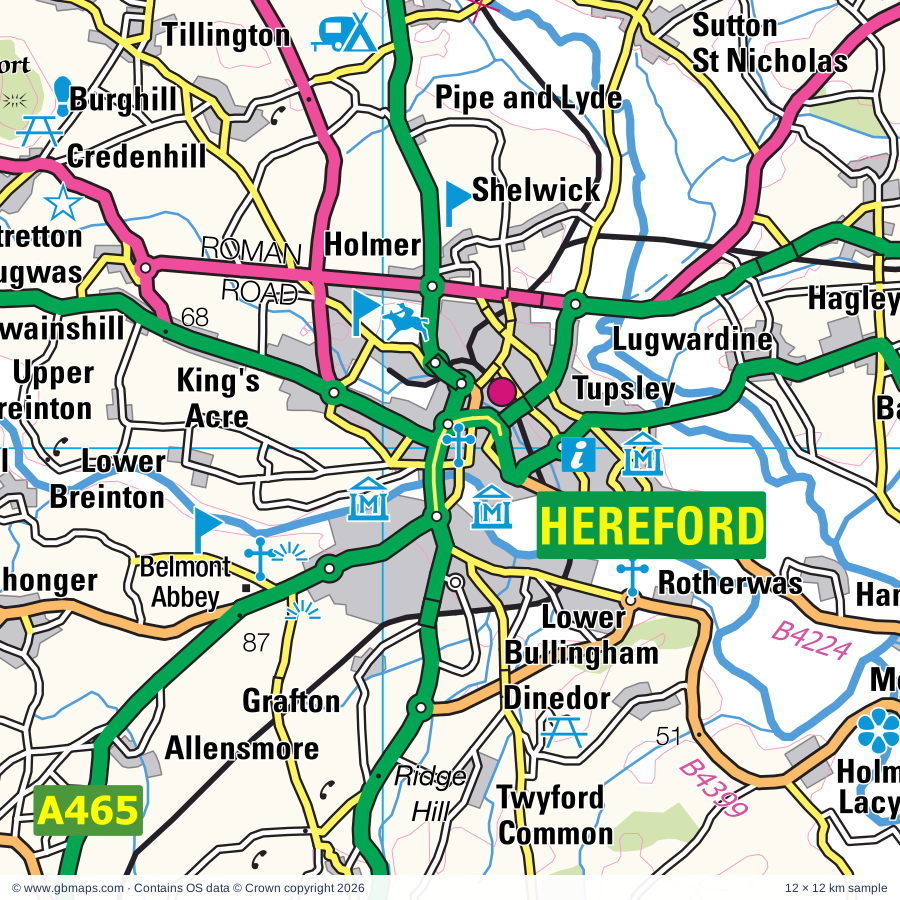
Hereford regional road map. Full 60 × 60 km PDF, SVG and Illustrator files, with a free PDF sample.

GBMAPS.COM

Hereford Regional Road Map

Call Us Now for Help01751 473136

GREAT BRITAIN ROAD ATLAS · 1:250,000 GB-360-0240

Hereford & surrounding area

Explore the full 60 × 60 km Hereford regional road map at 1:250,000, covering Hereford, Worcester, Gloucester, Ledbury, Bromyard. Compare the complete coverage below; a detailed PDF sample is available free.

HEREFORD & SURROUNDING AREAREGIONAL ROAD MAP
60 × 60 km · Full map previewDownload the free SVG ↓

INSIDE THE FULL 60 × 60 KM MAP

Explore the Hereford map area

1:250,000 cartography

Towns, villages & places

More mapped places (373)

Roads across this sheet

M5, M50, A38, A40, A44, A46, A417, A430, A438, A442, A443, A449, A451, A456, A465, A466, A480, A4019, A4025, A4103, A4104, A4110, A4111, A4112

More road numbers

A4133, A4136, A4137, A4151, A4172, A4173, A4301, A4302, A4440, A4536, A4538, B4008, B4024, B4028, B4063, B4072, B4073, B4080, B4084, B4090, B4146, B4194, B4196, B4197, B4202, B4203, B4204, B4205, B4206, B4208, B4209, B4211, B4213, B4214, B4215, B4216, B4218, B4219, B4220, B4221, B4222, B4224, B4226, B4227, B4228, B4230, B4232, B4233, B4234, B4260, B4269, B4293, B4299, B4347, B4348, B4349, B4352, B4355, B4356, B4359, B4360, B4361, B4362, B4399, B4424, B4432, B4457, B4482, B4485, B4503, B4521, B4529, B4550, B4598, B4634, B4636, B4637, B4638, B4639, B4641

Rivers & waterways

Afon Honddu, Afon Mynwy / River Monnow, Afon Troddu / River Trothy, Canal (disused), Coombe Hill Canal (disused), Droitwich Barge Canal, Gloucester & Sharpness Canal, Ledwyche Brook, Letton Lake, Monmouthshire & Brecon Canal, River Arrow, River Avon

More waterways

River Dore, River Frome, River Leadon, River Lodon, River Lugg, River Rea, River Severn, River Teme, River Usk / Afon Wsyg, River Wye, Stroudwater Canal (disused), Worcester & Birmingham Canal

Landmarks & landscape

Abbey Dore, Abbey Dore Court Gardens, Abergavenny Museum, Arthur's Stone, Ashleworth Tithe Barn, Astley Vineyard, Beechenhurst Lodge Visitor Centre, Forest of Dean Sculpture Trail, Belmont Abbey, Berrington Hall, Bevere Vivis Gallery, Bircher Common, Bird Attraction, BRECON BEACONS NATIONAL PARK

More named features

Broadfields Vineyards, Broadmoor Common, Brobury Garden, Broome Farm, Bryans Ground Gardens, Buckholt Wood National Nature Reserve and Cooper's Hill Nature Reserve, Burford House Garden, Burton Court, Butcher's Row House and Folk Museum, Toy Museum, Ledbury Heritage Centre, City Museum & Art Gallery, Beatrix Potter Museum and House of the Tailor of Gloucester, Clives Fruit Farm, Coddington Vineyard, Croft Castle, Croome Park, Cyril Hart Aboretum, Dewsall Court, Dick Whittington Farm Park, Dovecote, Droitwich Spa Heritage Centre, Dunkerton's Cider Mill, Eastnor Castle, Edvin Loach Old Church, Frome Valley Vineyard, GWR Museum, Gateway Museum, Gloucester Cathedral, Goodrich Castle, Goodrich Castle Visitor Centre, Great Witcombe Roman Villa, Greyfriars Gloucester, Blackfriars Gloucester, Grosmont Castle, Harts Barn Craft Centre, Hellens, Hen Gwrt Moated Site, Hereford Cathedral, Hereford Racecourse, Highnam Woods, Historic Gloucester Docks, St James City Farm, The Warehouse Climbing Wall, Hopwell Colliery Mining Museum, How Caple Court Gardens, Jet Age Museum, Kentchurch Court, Kington Museum, Knapp & Papermill Nature Reserve, Kyre Park Gardens, Langstone Court, Leigh Court Barn, Leominster Folk Museum, Little Malvern Court, Littledean Jail, Llanvihangel Court, Longtown Castle, Lower Brockhampton, Lyne Down Cider Factory, Market House Heritage Centre, Mocca's Court, Monk Wood Nature Reserve, Monmouth Castle, Monnow Valley Arts, Mortimer's Cross Water Mill, National Birds of Prey Centre, National Waterways Museum, Gloucester Folk Museum, Soldiers of Gloucestshire, Naval Temple, Nelson Museum & Local History Centre, Regimental Museum, Oaker Wood, Odda's Chapel, Old House Museum, St John Mediaeval Museum, City Museum, Cider Museum, Over Bridge, Painswick Rococo Garden, Penpergwm Lodge, Penyclawdd Court, Prinknash Abbey, Prinknash Bird Park, Prinknash Park, Queenswood Country Park, Ravenshill Nature Reserve, Regimental Museum, County Record Office, Castle Green, Robinswood Country Park, Rotherwas Chapel, Ruardean Garden Pottery, Shipley Gardens, Shobdon Arches Visitor Centre, Shortwood Family Farm, Skenfrith Castle, Spetchley Park Gardens, St Ann's Well, St Anne's Vineyard, St Augustine's Farm, St Mary's Church, Stockton Bury Gardens, Taste for Adventure, Tenbury Wells Museum, Tewkesbury Abbey, Tewkesbury Museum, John Moore Countryside Museum, Little Museum, The Amazing Hedge Puzzle, Wye Valley Butterfly Zoo, Wye Valley Visitor Centre, The Bannut, The Barn Owl Centre, The Bounds Cider Mill, The Commandery, The Elgar Birthplace Museum, The Greyfriars, The Picton Garden & Old Court Nurseries, The Pleck Cheese Dairy, The Time Machine Museum , Cafe & Local History Centre, The Violette Szabo Museum, The Weir, Three Choirs Vineyard, Three Counties Showground, Tithe Barn, Van Kampen Gardens, Visitor Centre, Wallsworth Hall Nature in Art Museum, Warren Farm, Waterworks Museum, Weobley Museum, Westbury Court Garden, Westonbury Mill, White Castle, Wigmore Castle, Withybeds and Wents Meadow, Witley Court, Wobage Farm Craft Workshop, Worcester Cathedral, Worcester City Museum and Art Gallery, Tudor House, Museum of Worcester Porcelain, Worcester Foregate St Museum, The Commandery, Worcester Racecourse, Worcester Woods Country Park
Local authority & parish coverage

Wholly or partly within the full map rectangle. These boundaries are coverage information, not additional artwork layers.

  • County of HerefordshirePartly within
  • Forest of Dean DistrictPartly within
  • Gloucester DistrictWholly within
  • Malvern Hills DistrictPartly within
  • Powys - PowysPartly within
  • ShropshirePartly within
  • Sir Fynwy - MonmouthshirePartly within
  • Stroud DistrictPartly within
  • Tewkesbury DistrictPartly within
  • Worcester DistrictWholly within
  • Wychavon DistrictPartly within
  • Wyre Forest DistrictPartly within
Wards & electoral divisions 176 areas
  • Abbeydale Ward
  • Abbeymead Ward
  • Alfrick, Leigh & Rushwick Ward
  • Arboretum Ward
  • Areley Kings & Riverside Ward (part)
  • Arrow Ward (part)
  • Aylestone Hill Ward
  • Backbury Ward
  • Badgeworth Ward (part)
  • Baldwin Ward (part)
  • Barnards Green Ward
  • Barnwood Ward
  • Barton & Tredworth Ward
  • Battenhall Ward
  • Belmont Rural Ward
  • Berry Hill Ward
  • Bewdley & Rock Ward (part)
  • Birch Ward
  • Bircher Ward (part)
  • Bishops Frome & Cradley Ward
  • Bobblestock Ward
  • Bowbrook Ward (part)
  • Bream Ward (part)
  • Bredon Ward (part)
  • Broadheath Ward
  • Brockworth East Ward (part)
  • Brockworth West Ward
  • Bromyard Bringsty Ward
  • Bromyard West Ward
  • Castle Ward (part)
  • Castlemorton, Welland & Wells Ward
  • Cathedral Ward
  • Central Ward
  • Churchdown Brookfield with Hucclecote Ward
  • Churchdown St. John's Ward
  • Cinderford East Ward
  • Cinderford West Ward
  • Claines Ward
  • Coleford Ward (part)
  • College Ward
  • Coney Hill Ward
  • Credenhill Ward
  • Dinedor Hill Ward
  • Dines Green & Grove Farm Ward
  • Dodderhill Ward (part)
  • Drakes Broughton, Norton & Whittington Ward (part)
  • Droitwich East Ward (part)
  • Droitwich South East Ward (part)
  • Droitwich South West Ward (part)
  • Droitwich West Ward
  • Dymock Ward
  • Eckington Ward (part)
  • Eign Hill Ward
  • Elmbridge Ward
  • Fort Royal Ward
  • Golden Valley North Ward (part)
  • Golden Valley South Ward (part)
  • Grange Ward
  • Great Malvern Ward
  • Greyfriars Ward
  • Hagley Ward
  • Hallow & Holt Ward
  • Hampton Ward
  • Hardwicke Ward (part)
  • Hartlebury Ward (part)
  • Hartpury & Redmarley Ward
  • Highnam with Haw Bridge Ward
  • Hinton & Hunderton Ward
  • Holmer Ward
  • Hope End Ward
  • Hucclecote Ward
  • Innsworth Ward
  • Kempsey Ward
  • Kerne Bridge Ward
  • Kings Acre Ward
  • Kingsholm & Wotton Ward
  • Kingsway Ward
  • Kington Ward (part)
  • Ledbury North Ward
  • Ledbury South Ward
  • Ledbury West Ward
  • Leominster East Ward
  • Leominster North & Rural Ward (part)
  • Leominster South Ward
  • Leominster West Ward
  • Leopard Hill Ward
  • Lindridge Ward (part)
  • Link Ward
  • Llangarron Ward
  • Longdon Ward
  • Longhope & Huntley Ward
  • Longlevens Ward
  • Lower Wick & Pitmaston Ward
  • Lydbrook Ward
  • Martley Ward
  • Matson, Robinswood and White City Ward
  • Mitcheldean, Ruardean & Drybrook Ward
  • Mitton Ward (part)
  • Moreland Ward
  • Mortimer Ward (part)
  • Newent & Taynton Ward
  • Newland & Sling Ward (part)
  • Newnham Ward (part)
  • Newton Farm Ward
  • North Claines & Salwarpe Ward (part)
  • Nunnery Ward
  • Old Gore Ward
  • Ombersley Ward (part)
  • Painswick & Upton Ward (part)
  • Penyard Ward
  • Pickersleigh Ward
  • Podsmead Ward
  • Powick & the Hanleys Ward
  • Quedgeley Fieldcourt Ward
  • Quedgeley Severn Vale Ward
  • Queenswood Ward
  • Rainbow Hill Ward
  • Red Hill Ward
  • Ross East Ward
  • Ross North Ward
  • Ross West Ward
  • Ruspidge Ward (part)
  • Saxon Gate Ward
  • Severn Vale North Ward (part)
  • Severn Vale South Ward (part)
  • Severn Ward (part)
  • St. Clement Ward
  • St. John's Ward
  • St. Nicholas Ward
  • St. Peter's Parish Ward
  • St. Stephen Ward
  • Stoney Street Ward
  • Sutton Walls Ward
  • Tenbury Ward
  • Tewkesbury East Ward (part)
  • Tewkesbury North & Twyning Ward (part)
  • Tewkesbury South Ward (part)
  • Three Crosses Ward
  • Tuffley Ward
  • Tupsley Ward
  • Upper Howsell Ward
  • Upton & Ripple Ward
  • Upton Snodsbury Ward (part)
  • Warndon & Elbury Park Ward
  • Weobley Ward
  • West Ward
  • Westbury-on-Severn Ward
  • Westgate Ward
  • Whitecross Ward
  • Widemarsh Ward
  • Wormside Ward
  • Wyre Forest Rural Ward (part)
  • Clee ED (part)
  • Cleobury Mortimer ED (part)
  • Croesonen ED
  • Crucorney ED (part)
  • Drybridge ED
  • Gobion Fawr ED (part)
  • Goetre Fawr ED (part)
  • Grofield ED (part)
  • Knighton with Beguildy ED (part)
  • Lansdown ED (part)
  • Llanfoist Fawr and Govilon ED (part)
  • Llangunllo with Norton ED (part)
  • Llantilio Crossenny ED
  • Ludlow South ED (part)
  • Mardy ED (part)
  • Mitchel Troy and Trellech United ED (part)
  • Old Radnor ED (part)
  • Osbaston ED
  • Overmonnow ED
  • Park ED (part)
  • Pen Y Fal ED (part)
  • Presteigne ED (part)
  • Town ED
  • Wyesham ED
Civil parishes & communities 423 areas
  • Abberley CP
  • Abbey Dore CP
  • Abergavenny Community (part)
  • Aconbury CP
  • Acton Beauchamp CP
  • Adforton CP (part)
  • Alfrick CP
  • Allensmore CP
  • Almeley CP
  • Arlingham CP (part)
  • Ashford Bowdler CP (part)
  • Ashford Carbonel CP (part)
  • Ashleworth CP
  • Ashperton CP
  • Astley and Dunley CP (part)
  • Aston Ingham CP
  • Avenbury CP
  • Aylton CP
  • Aymestrey CP (part)
  • Bacton CP
  • Badgeworth CP (part)
  • Ballingham CP
  • Bartestree CP
  • Belmont Rural CP
  • Berrow CP
  • Besford CP (part)
  • Birley with Upper Hill CP
  • Birtsmorton CP
  • Bishop's Frome CP
  • Bishopstone CP
  • Blaisdon CP
  • Blakemere CP
  • Bockleton CP
  • Boddington CP (part)
  • Bodenham CP
  • Bolstone CP
  • Boraston CP (part)
  • Bosbury CP
  • Brampton Abbotts CP
  • Brampton Bryan CP (part)
  • Bransford CP
  • Bredenbury CP
  • Bredicot CP (part)
  • Bredon CP (part)
  • Bredwardine CP
  • Breinton CP
  • Bridge Sollers CP
  • Bridstow CP
  • Brimfield CP
  • Brinsop and Wormsley CP
  • Broadwas CP
  • Brobury with Monnington on Wye CP
  • Brockhampton CP
  • Brockhampton CP
  • Brockworth CP (part)
  • Bromesberrow CP
  • Bromyard and Winslow CP
  • Brookthorpe-with-Whaddon CP
  • Burford CP (part)
  • Burghill CP
  • Bushley CP
  • Byford CP
  • Byton CP
  • Callow CP
  • Canon Frome CP
  • Canon Pyon CP
  • Castle Frome CP
  • Castlemorton CP
  • Chaceley CP
  • Churcham CP
  • Churchdown CP
  • Cinderford CP
  • Clehonger CP
  • Clifford CP (part)
  • Clifton upon Teme CP
  • Coddington CP
  • Coleford CP (part)
  • Collington CP
  • Colwall CP
  • Combe CP
  • Corse CP
  • Cotheridge CP
  • Cradley and Storridge CP
  • Cranham CP (part)
  • Craswall CP (part)
  • Credenhill CP
  • Croft and Yarpole CP
  • Croome D'abitot CP
  • Crucorney Community (part)
  • Deerhurst CP
  • Defford CP (part)
  • Dewsall CP
  • Dilwyn CP
  • Dinedor CP
  • Dinmore CP
  • Docklow and Hampton Wafer CP
  • Doddenham CP
  • Dodderhill CP (part)
  • Donnington CP
  • Dormington CP
  • Dorstone CP (part)
  • Doverdale CP
  • Down Hatherley CP
  • Drakes Broughton and Wadborough CP (part)
  • Droitwich Spa CP (part)
  • Drybrook CP
  • Dulas CP
  • Dymock CP
  • Eardisland CP
  • Eardisley CP (part)
  • Earl's Croome CP
  • Eastham CP
  • Eastnor CP
  • Eaton Bishop CP
  • Edvin Loach and Saltmarshe CP
  • Edwyn Ralph CP
  • Eggleton CP
  • Eldersfield CP
  • Elmbridge CP (part)
  • Elmley Lovett CP (part)
  • Elmore CP
  • Elmstone Hardwicke CP (part)
  • Elton CP (part)
  • English Bicknor CP
  • Evesbatch CP
  • Ewyas Harold CP
  • Eye, Moreton and Ashton CP
  • Eyton CP
  • Felton CP
  • Ford and Stoke Prior CP
  • Forthampton CP
  • Fownhope CP
  • Foy CP
  • Fretherne with Saul CP (part)
  • Ganarew CP
  • Garway CP
  • Gobion Fawr Community (part)
  • Goetre Fawr Community (part)
  • Goodrich CP
  • Gorsley and Kilcot CP
  • Grafton CP
  • Great Witcombe CP (part)
  • Great Witley CP
  • Greete CP (part)
  • Grendon Bishop CP
  • Grimley CP
  • Grosmont Community
  • Guarlford CP
  • Hallow CP
  • Hampton Bishop CP
  • Hampton Charles CP
  • Hampton Lovett CP (part)
  • Hanley CP
  • Hanley Castle CP
  • Hardwicke CP
  • Harescombe CP (part)
  • Haresfield CP (part)
  • Harewood CP
  • Hartlebury CP (part)
  • Hartpury CP
  • Hasfield CP
  • Hatfield and Newhampton CP
  • Haywood CP
  • Hentland CP
  • Hereford CP
  • Highnam CP
  • Hill Croome CP
  • Hillhampton CP
  • Hindlip CP (part)
  • Holdfast CP
  • Holme Lacy CP
  • Holmer & Shelwick CP
  • Holt CP
  • Hope Mansell CP
  • Hope under Dinmore CP
  • How Caple CP
  • Hucclecote CP
  • Humber CP
  • Huntley CP
  • Hunts Grove CP
  • Innsworth CP
  • Kempley CP
  • Kempsey CP
  • Kenchester CP
  • Kenswick CP
  • Kentchurch CP
  • Kilpeck CP
  • Kimbolton CP
  • King's Pyon CP
  • Kings Caple CP
  • Kingsland CP
  • Kingstone CP
  • Kington CP (part)
  • Kington Rural CP (part)
  • Kinnersley CP
  • Kinsham CP
  • Knighton Community (part)
  • Knighton on Teme CP (part)
  • Knightwick CP
  • Knill CP (part)
  • Kyre CP
  • Lea CP
  • Ledbury CP
  • Leigh CP
  • Leigh CP
  • Leinthall Starkes CP (part)
  • Leominster CP
  • Letton CP
  • Leysters CP
  • Lindridge CP (part)
  • Lingen CP
  • Linton CP
  • Linton CP
  • Little Birch CP
  • Little Cowarne CP
  • Little Dewchurch CP
  • Little Hereford CP (part)
  • Little Malvern CP
  • Little Marcle CP
  • Little Witley CP
  • Littledean CP
  • Llanarth Community (part)
  • Llancillo CP
  • Llandinabo CP
  • Llanfoist Fawr Community (part)
  • Llangarron CP
  • Llanrothal CP
  • Llantilio Pertholey Community (part)
  • Llanveynoe CP (part)
  • Llanwarne CP
  • Longdon CP
  • Longford CP
  • Longhope CP
  • Longney and Epney CP (part)
  • Longtown CP
  • Lower Broadheath CP
  • Lower Bullingham CP
  • Lower Sapey CP
  • Lucton CP
  • Lugwardine CP
  • Lulsley CP
  • Luston CP
  • Lydbrook CP
  • Lyonshall CP
  • Madley CP
  • Madresfield CP
  • Maisemore CP
  • Malvern CP
  • Malvern Wells CP
  • Mamble CP (part)
  • Mansell Gamage CP
  • Mansell Lacy CP
  • Marden CP
  • Marstow CP
  • Martin Hussingtree CP
  • Martley CP
  • Mathon CP
  • Michaelchurch Escley CP (part)
  • Middleton-on-the-Hill CP
  • Minsterworth CP
  • Miserden CP (part)
  • Mitchel Troy Community (part)
  • Mitcheldean CP
  • Moccas CP
  • Monkland and Stretford CP
  • Monmouth Community
  • Mordiford CP
  • Moreton Jeffries CP
  • Moreton Valence CP (part)
  • Moreton on Lugg CP
  • Much Birch CP
  • Much Cowarne CP
  • Much Dewchurch CP
  • Much Marcle CP
  • Munsley CP
  • Nash CP (part)
  • Newent CP
  • Newland CP
  • Newland CP (part)
  • Newnham CP (part)
  • Newton CP
  • Newton CP
  • North Claines CP
  • Norton CP
  • Norton CP
  • Norton Canon CP
  • Norton Juxta Kempsey CP (part)
  • Ocle Pychard CP
  • Old Radnor Community (part)
  • Ombersley CP
  • Orcop CP
  • Orleton CP
  • Oxenhall CP
  • Painswick CP (part)
  • Pauntley CP
  • Pembridge CP
  • Pencombe with Grendon Warren CP
  • Pencoyd CP
  • Pendock CP
  • Pensax CP
  • Peterchurch CP (part)
  • Peterstow CP
  • Pipe and Lyde CP
  • Pirton CP (part)
  • Pixley CP
  • Powick CP
  • Presteigne Community (part)
  • Preston Wynne CP
  • Preston on Wye CP
  • Pudlestone CP
  • Putley CP
  • Quedgeley CP
  • Queenhill CP
  • Redmarley D'abitot CP
  • Richard's Castle (Shropshire) CP (part)
  • Richards Castle (Hereford) CP (part)
  • Ripple CP
  • Rochford CP
  • Rock CP (part)
  • Rodd, Nash and Little Brampton CP (part)
  • Ross-on-Wye CP
  • Rowlstone CP
  • Ruardean CP
  • Rudford and Highleadon CP
  • Rushock CP (part)
  • Rushwick CP
  • Ruspidge and Soudley CP (part)
  • Salwarpe CP (part)
  • Sandhurst CP
  • Sarnesfield CP
  • Sellack CP
  • Severn Stoke CP
  • Shelsley Beauchamp CP
  • Shelsley Kings CP
  • Shelsley Walsh CP
  • Shobdon CP
  • Shrawley CP
  • Skenfrith Community
  • Sollers Hope CP
  • Spetchley CP (part)
  • St. Margarets CP
  • St. Peter the Great County CP
  • St. Weonards CP
  • Standish CP (part)
  • Stanford Bishop CP
  • Stanford with Orleton CP
  • Stapleton CP
  • Staunton CP
  • Staunton Coleford CP
  • Staunton on Arrow CP
  • Staunton on Wye CP
  • Staverton CP (part)
  • Stockton on Teme CP
  • Stoke Bliss CP
  • Stoke Edith CP
  • Stoke Lacy CP
  • Stoke Orchard CP (part)
  • Stoulton CP (part)
  • Stourport-on-Severn CP (part)
  • Strensham CP (part)
  • Stretton Grandison CP
  • Stretton Sugwas CP
  • Suckley CP
  • Sutton CP
  • Tarrington CP
  • Taynton CP
  • Tedstone Delamere CP
  • Tedstone Wafer CP
  • Tenbury CP
  • Tewkesbury CP (part)
  • Thornbury CP
  • Thruxton CP
  • Tibberton CP
  • Tibberton CP (part)
  • Tirley CP
  • Titley CP
  • Trellech United Community (part)
  • Tretire with Michaelchurch CP
  • Turnastone CP
  • Twigworth CP
  • Twyning CP (part)
  • Tyberton CP
  • Ullingswick CP
  • Upleadon CP
  • Upper Sapey CP
  • Upton Bishop CP
  • Upton St. Leonards CP
  • Upton Warren CP (part)
  • Upton-upon-Severn CP
  • Vowchurch CP
  • Wacton CP
  • Walford CP
  • Walford, Letton and Newton CP (part)
  • Walterstone CP
  • Warndon CP
  • Welland CP
  • Wellington CP
  • Wellington Heath CP
  • Welsh Bicknor CP
  • Welsh Newton CP
  • Weobley CP
  • West Dean CP (part)
  • West Malvern CP
  • Westbury-on-Severn CP
  • Westhide CP
  • Weston Beggard CP
  • Weston under Penyard CP
  • Westwood CP
  • Wheatpieces CP (part)
  • Whitbourne CP
  • Whitchurch CP
  • Whitecastle Community
  • Whittington CP (part)
  • Wichenford CP
  • Wigmore CP (part)
  • Willersley and Winforton CP (part)
  • Willey CP (part)
  • Withington CP
  • Wolferlow CP
  • Woolhope CP
  • Yarkhill CP
  • Yatton CP
  • Yazor CP

Source: the GBMaps road atlas, OS Boundary-Line and postcode mapping datasets. Source editions are being checked for publication. Unmarked boundary names are wholly within the sheet; “part” means the map edge crosses the area.

Place lists are selected from the map source, not a complete gazetteer. Named features describe the cartography; visitor facilities and opening status are not verified. The free sample covers only 12 × 12 km of this larger sheet.

INSIDE YOUR DOWNLOAD

A proper road map, in useful formats

Road classifications, towns and villages, railways, rivers, landscape detail and tourist symbols, brought together in the GBMaps regional road atlas style.

PDF filePDFSVG fileSVGAdobe Illustrator AI fileAi

PDF for the finished map. SVG and layered Illustrator artwork for adapting colours, adding your own information and preparing designs.

THE FINISHED SHEET

Designed for print and presentation

Map coverage
60 × 60 km
Sample coverage
12 × 12 km
Print layout
A3 landscape · enlarged 1:250k cartography
Sheet furniture
Border, scale bar, key & north arrow

A few useful details

What changes when I select another square?

Select a surrounding square to bring it into the centre and reveal the maps around it. Each square is a different 60 × 60 km map. The preview, free sample and selected download change together. Neighbouring sheets overlap by 30 km so you can choose the coverage that suits you.

Is the free sample a vector map?

The on-page detail is an SVG. The free download is a separate 12 × 12 km PDF with a link to the full map. Please retain its copyright credits and product link when sharing it.

Can I buy a larger combined map?

These downloads are individual ready-made sheets. Contact GBMaps if you need a larger combined area.

FREE PDF SAMPLE

Your free map sample

Your free 12 × 12 km sample includes a link back to this map, so you can return for the full area whenever you need it.

Download free PDF sample ↓

Get your Hereford map

Map download bundle

£24.00including VATOne payment

Pay securely

One payment. Your map stays open.

Your map download

Your map files

Preparing your download…

Checking your private download link…

Your map downloads

Already bought a map?

Find the downloads from your purchases.

Enter the email address you used at checkout. We’ll email you a private link to your available map downloads.