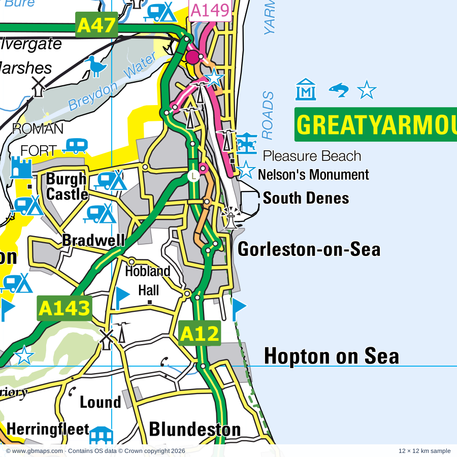
Gorleston-on-Sea regional road map. Full 60 × 60 km PDF, SVG and Illustrator files, with a free PDF sample.

GBMAPS.COM

Gorleston-on-Sea Regional Road Map

Call Us Now for Help01751 473136

GREAT BRITAIN ROAD ATLAS · 1:250,000 GB-660-0300

Gorleston-on-Sea & surrounding area

Explore the full 60 × 60 km Gorleston-on-Sea regional road map at 1:250,000, covering Gorleston-on-Sea, Lowestoft, Beccles, Loddon, Southwold. Compare the complete coverage below; a detailed PDF sample is available free.

GORLESTON-ON-SEA & SURROUNDING AREAREGIONAL ROAD MAP
60 × 60 km · Full map previewDownload the free SVG ↓

INSIDE THE FULL 60 × 60 KM MAP

Explore the Gorleston-on-Sea map area

1:250,000 cartography

Towns, villages & places

More mapped places (153)
  • St Olaves
  • Gisleham
  • Kessingland
  • Wheatacre
  • Barnby
  • Aldeby
  • Mutford
  • Haddiscoe
  • Thorpe
  • North Cove
  • Rushmere
  • Runham
  • California
  • Mautby
  • Henstead
  • Toft Monks
  • Benacre
  • Scratby
  • Reedham
  • Wickhampton
  • Thrigby
  • Worlingham
  • Thurlton
  • Maypole Green
  • Filby
  • Newport
  • Halvergate
  • Freethorpe
  • Covehithe
  • Tunstall
  • Stokesby
  • Wrentham
  • Hemsby
  • Ellough
  • Raveningham
  • Limpenhoe
  • Cuckold's Green
  • Gillingham
  • Southwood
  • Burgh St Margaret
  • Weston
  • Sotterley
  • South Cove
  • Billockby
  • Stockton
  • Hales
  • Rollesby
  • Damgate
  • Winterton-on-Sea
  • Frostenden
  • Geldeston
  • Cantley
  • Acle
  • Ringsfield
  • Clippesby
  • Shadingfield
  • Martham
  • East Somerton
  • Barsham
  • Beighton
  • Langley Street
  • West Somerton
  • Barnaby Green
  • Hassingham
  • Upton
  • Stoven
  • Chedgrave
  • Shipmeadow
  • Ellingham
  • Brampton
  • Reydon
  • Redisham
  • Wangford
  • Buckenham
  • Repps
  • Lingwood
  • Bastwick
  • Uggeshall
  • Sisland
  • Thurne
  • Mettingham
  • Strumpshaw
  • Claxton
  • Broome
  • Mill Common
  • Westhall
  • Mundham
  • Horsey
  • South Walsham
  • Thurton
  • Ditchingham
  • Ashby St Mary
  • Walberswick
  • Stone Street
  • Panxworth
  • Ranworth
  • Ludham
  • High Street
  • Hemblington
  • Seething
  • Rockland St Mary
  • Blofield
  • Brundall
  • Hellington
  • Blythburgh
  • Blyford
  • Surlingham
  • Hedenham
  • Spexhall
  • Earsham
  • Holton
  • Wenhaston
  • Hickling
  • Mells
  • Catfield
  • Waxham
  • Woodbastwick
  • Irstead
  • Wissett
  • Horning
  • Rumburgh
  • Thorington
  • Flixton
  • Sutton
  • Sea Palling
  • Dunwich
  • Salhouse
  • Chediston
  • Bramfield
  • Neatishead
  • Barton Turf
  • Ingham
  • Pennygate
  • Hempstead
  • Walpole
  • Hoveton
  • Lessingham
  • Darsham
  • Eccles on Sea
  • Cookley
  • Ashmanhaugh
  • Metfield Common
  • Whimpwell Green
  • Smallburgh
  • Huntingfield
  • Dilham
  • Cratfield
  • Heveningham
  • Sibton
  • Honing
  • Ubbeston
  • Worstead
  • Crostwight

Roads across this sheet

A12, A47, A143, A144, A145, A146, A149, A1062, A1064, A1095, A1117, A1144, A1145, A1151, A1243, B1062, B1074, B1117, B1123, B1124, B1125, B1126, B1127, B1136

More road numbers

B1140, B1141, B1152, B1159, B1332, B1354, B1370, B1375, B1384, B1385, B1387, B1435, B1437, B1531, B1532

Rivers & waterways

Canal, Hundred Stream, North Walsham & Dilham Canal (disused), River Ant, River Blyth, River Bure, River Chet, River Thurne, River Waveney

Landmarks & landscape

Africa Alive, Alderfen Broad Nature Reserve, Barton Broad Nature Reserve, Beccles & District Museum, Benacre Nature Reserve, Berney Arms Nature Reserve, Bewilderwood, Bigods Castle, Breydon Water Nature Reserve, Britannia Pier and Theatre, Wellington Pier and Theatre, Broadlands Art Centre, Bungay Castle (Bigods Castle), THE BROADS

More named features

Bungay Museum, Burgh Castle, Caister Castle Motor Museum, Caister Nova Scotia Solar Farm, Caister Roman Site, Caister-on-Sea Castle, Carlton Marches Wildlife Centre, Carlton Marshes Nature Reserve, Chediston Hall Solar Farm, Dunwich Museum, East Anglian Transport Museum, East Ruston Old Vicarage Garden, Euroscope, Fairhaven Gardens Trust, Fritton Lake Country World, Great Yarmouth Pleasure Beach, Great Yarmouth Racecourse, Great Yarmouth Sea Life Centre, Hales Hall, Halesworth & District Museum, Halesworth (Holton) Airfield Station 365 Memorial Museum, Hardley Windmill Visitor Centre, Herringfleet Drainage Mill, Hickling Broad National Nature Reserve, Hobland Hall, Horning Parish Staithe (West), Horning Parish Staithe (East), Mississippi Paddle Boat, Horsey Mere Drainage Mill, Horsey Mere Moorings, Hoveton Great Broad Nature Reserve, Hoveton Hall Gardens, How Hill/Reedham Marsh Nature Reserve, Irstead Staithe Moorings, Lowestoft Museum, East Suffolk Maritime Museum, Lowestoft Memorial Museum, ISCA Maritime Museum, Ludham (Womack Staithe), Ludham Bridge Drainage Mill, Maritime Museum, Merrivale Model Village, Mid Yare Nature Reserve, Museum of the Broads, Neatishead Air Defence Radar Museum, Neatishead Moorings, Gay's Staithe Moorings, Nelson's Monument, Norfolk & Suffolk Aviation Museum, Oasis Camel Centre, Old Merchants House Row 117, Row 111 House, Greyfriars Cloisters, Paddy's Lane Barton Moorings, Pettitts Animal Adventure Park, Pleasurewood Hills Family Theme Park, Potter Heigham New Bridge Moorings, ROMAN FORT, Ranworth Broad Nature Reserve, Ranworth Staithe Visitor Centre, Raveningham Gardens, Somerleyton Hall, Southwold Museum, The Amber Museum, Sailor Reading Room, St Olave's Priory, St Olaves Drainage Mill, Stracey Arms Drainage Mill, Strumpshaw Hall Steam Museum, Suffolk Apple Juice and Cider Press, Surlingham Broad Nature Reserve, Sutton (Windmill) Pottery, Sutton Staithe Moorings, Ted Ellis Nature Reserve, Thrigby Hall Wildlife Gardens, Toad Hall Cottage Centre, Toad Hole Cottage, Tollhouse Museum, Elizabethan House Museum, Norfolk Nelson Museum, Time and Tide Museum, Potteries and Herring Smoking Museum, Herring Smoking Museum, Turf Fen Drainage Mill, USAAF 446th Bomb Group War Memorial, Upton Fen Nature Reserve, Visitor Centre, Walberswick Nature Reserve, Waveney River Centre, Waxham Great Barn, West Somerton Moorings, Winterton Dunes Nature Reserve, Wite Slea Moorings, Heigham Sound, Wroxham Barns Craft & Farm Attraction
Local authority & parish coverage

Wholly or partly within the full map rectangle. These boundaries are coverage information, not additional artwork layers.

  • Broadland DistrictPartly within
  • East Suffolk DistrictPartly within
  • Great Yarmouth DistrictWholly within
  • Mid Suffolk DistrictPartly within
  • North Norfolk DistrictPartly within
  • Norwich DistrictPartly within
  • South Norfolk DistrictPartly within
Wards & electoral divisions 55 areas
  • Acle Ward
  • Bacton Ward (part)
  • Beccles & Worlingham Ward
  • Blofield with South Walsham Ward
  • Bradwell North Ward
  • Bradwell South and Hopton Ward
  • Brooke Ward (part)
  • Brundall Ward (part)
  • Bungay & Wainford Ward (part)
  • Burlingham Ward
  • Caister North Ward
  • Caister South Ward
  • Carlton & Whitton Ward
  • Carlton Colville Ward
  • Central And Northgate Ward
  • Claydon Ward
  • Ditchingham & Earsham Ward (part)
  • East Flegg Ward
  • Fleggburgh Ward
  • Framlingham Ward (part)
  • Fressingfield Ward (part)
  • Gorleston Ward
  • Gunton & St. Margarets Ward
  • Halesworth & Blything Ward
  • Happisburgh Ward (part)
  • Harbour & Normanston Ward
  • Hickling Ward
  • Hoveton & Tunstead Ward (part)
  • Kelsale & Yoxford Ward (part)
  • Kessingland Ward
  • Kirkley & Pakefield Ward
  • Loddon & Chedgrave Ward
  • Lothingland Ward
  • Lothingland Ward
  • Magdalen Ward
  • Marshes Ward
  • Nelson Ward
  • North Walsham East Ward (part)
  • Ormesby Ward
  • Oulton Broad Ward
  • Plumstead Ward (part)
  • Rockland Ward (part)
  • Southtown and Cobholm Ward
  • Southwold Ward
  • St. Andrews Ward
  • St. Benet's Ward
  • Stalham Ward
  • Stradbroke & Laxfield Ward (part)
  • Thorpe Hamlet Ward (part)
  • Thurlton Ward
  • West Flegg Ward
  • Worstead Ward (part)
  • Wrentham, Wangford & Westleton Ward (part)
  • Wroxham Ward (part)
  • Yarmouth North Ward
Civil parishes & communities 191 areas
  • Acle CP
  • Aldeby CP
  • All Saints and St. Nicholas, South Elmham CP
  • Alpington CP (part)
  • Ashby St. Mary CP
  • Ashby with Oby CP
  • Ashmanhaugh CP
  • Badingham CP (part)
  • Barnby CP
  • Barsham CP
  • Barton Turf CP
  • Beccles CP
  • Bedingham CP (part)
  • Beighton CP
  • Belaugh CP (part)
  • Belton with Browston CP
  • Benacre CP
  • Bergh Apton CP (part)
  • Blofield CP
  • Blundeston CP
  • Blyford CP
  • Blythburgh CP
  • Bradwell CP
  • Bramerton CP (part)
  • Bramfield CP
  • Brampton with Stoven CP
  • Brooke CP (part)
  • Broome CP
  • Brumstead CP
  • Brundall CP
  • Bungay CP
  • Burgh Castle CP
  • Burgh St. Peter CP
  • Caister-on-Sea CP
  • Cantley, Limpenhoe and Southwood CP
  • Carleton St. Peter CP
  • Carlton Colville CP
  • Catfield CP
  • Chedgrave CP
  • Chediston CP
  • Claxton CP
  • Cookley CP
  • Corton CP
  • Covehithe CP
  • Cratfield CP (part)
  • Darsham CP (part)
  • Dilham CP
  • Ditchingham CP
  • Dunwich CP (part)
  • Earsham CP (part)
  • East Ruston CP (part)
  • Ellingham CP
  • Ellough CP
  • Filby CP
  • Fleggburgh CP
  • Flixton CP (part)
  • Flixton CP
  • Freethorpe CP
  • Fressingfield CP (part)
  • Fritton and St. Olaves CP
  • Frostenden CP
  • Geldeston CP
  • Gillingham CP
  • Gisleham CP
  • Great and Little Plumstead CP (part)
  • Haddiscoe CP
  • Hales CP
  • Halesworth CP
  • Halvergate CP
  • Happisburgh CP (part)
  • Heckingham CP
  • Hedenham CP (part)
  • Hellington CP
  • Hemblington CP
  • Hemsby CP
  • Henstead with Hulver Street CP
  • Heveningham CP
  • Hickling CP
  • Holton CP
  • Holverston CP (part)
  • Honing CP (part)
  • Hopton-on-Sea CP
  • Horning CP
  • Horsey CP
  • Hoveton CP (part)
  • Huntingfield CP
  • Ingham CP
  • Kessingland CP
  • Kirby Cane CP
  • Kirstead CP (part)
  • Langley with Hardley CP
  • Laxfield CP (part)
  • Lessingham CP
  • Lingwood and Burlingham CP
  • Linstead Magna CP
  • Linstead Parva CP
  • Loddon CP
  • Lound CP
  • Lowestoft CP
  • Ludham CP
  • Martham CP
  • Mautby CP
  • Metfield CP (part)
  • Mettingham CP
  • Mundham CP
  • Mutford CP
  • Neatishead CP
  • North Cove CP
  • North Walsham CP (part)
  • Norton Subcourse CP
  • Ormesby St. Margaret with Scratby CP
  • Ormesby St. Michael CP
  • Oulton Broad CP
  • Oulton CP
  • Peasenhall CP (part)
  • Postwick with Witton CP (part)
  • Potter Heigham CP
  • Raveningham CP
  • Redisham CP
  • Reedham CP
  • Repps with Bastwick CP
  • Reydon CP
  • Ringsfield CP
  • Rockland St. Mary CP
  • Rollesby CP
  • Rumburgh CP
  • Rushmere CP
  • Salhouse CP (part)
  • Sea Palling CP
  • Seething CP
  • Shadingfield CP
  • Shipmeadow CP
  • Sibton CP (part)
  • Sisland CP
  • Sloley CP (part)
  • Smallburgh CP
  • Somerleyton, Ashby and Herringfleet CP
  • Somerton CP
  • Sotherton CP
  • Sotterley CP
  • South Cove CP
  • South Walsham CP
  • Southwold CP
  • Spexhall CP
  • St. Andrew, Ilketshall CP
  • St. Cross, South Elmham CP (part)
  • St. James, South Elmham CP
  • St. John, Ilketshall CP
  • St. Lawrence, Ilketshall CP
  • St. Margaret, Ilketshall CP
  • St. Margaret, South Elmham CP
  • St. Mary, South Elmham Otherwise Homersfield CP (part)
  • St. Michael, South Elmham CP
  • St. Peter, South Elmham CP
  • Stalham CP
  • Stockton CP
  • Stokesby with Herringby CP
  • Strumpshaw CP
  • Surlingham CP (part)
  • Sutton CP
  • Thorington CP
  • Thurlton CP
  • Thurne CP
  • Thurton CP
  • Thwaite CP
  • Toft Monks CP
  • Tunstead CP (part)
  • Ubbeston CP
  • Uggeshall CP
  • Upton with Fishley CP
  • Walberswick CP
  • Walpole CP
  • Wangford with Henham CP
  • Wenhaston with Mells Hamlet CP
  • West Caister CP
  • Westhall CP
  • Westleton CP (part)
  • Weston CP
  • Wheatacre CP
  • Willingham St. Mary CP
  • Winterton-on-Sea CP
  • Wissett CP
  • Witton CP (part)
  • Woodbastwick CP
  • Woodton CP (part)
  • Worlingham CP
  • Worstead CP (part)
  • Wrentham CP
  • Wroxham CP (part)
  • Yelverton CP (part)
  • Yoxford CP (part)

Source: the GBMaps road atlas, OS Boundary-Line and postcode mapping datasets. Source editions are being checked for publication. Unmarked boundary names are wholly within the sheet; “part” means the map edge crosses the area.

Place lists are selected from the map source, not a complete gazetteer. Named features describe the cartography; visitor facilities and opening status are not verified. The free sample covers only 12 × 12 km of this larger sheet.

INSIDE YOUR DOWNLOAD

A proper road map, in useful formats

Road classifications, towns and villages, railways, rivers, landscape detail and tourist symbols, brought together in the GBMaps regional road atlas style.

PDF filePDFSVG fileSVGAdobe Illustrator AI fileAi

PDF for the finished map. SVG and layered Illustrator artwork for adapting colours, adding your own information and preparing designs.

THE FINISHED SHEET

Designed for print and presentation

Map coverage
60 × 60 km
Sample coverage
12 × 12 km
Print layout
A3 landscape · enlarged 1:250k cartography
Sheet furniture
Border, scale bar, key & north arrow

A few useful details

What changes when I select another square?

Select a surrounding square to bring it into the centre and reveal the maps around it. Each square is a different 60 × 60 km map. The preview, free sample and selected download change together. Neighbouring sheets overlap by 30 km so you can choose the coverage that suits you.

Is the free sample a vector map?

The on-page detail is an SVG. The free download is a separate 12 × 12 km PDF with a link to the full map. Please retain its copyright credits and product link when sharing it.

Can I buy a larger combined map?

These downloads are individual ready-made sheets. Contact GBMaps if you need a larger combined area.

FREE PDF SAMPLE

Your free map sample

Your free 12 × 12 km sample includes a link back to this map, so you can return for the full area whenever you need it.

Download free PDF sample ↓

Get your Gorleston-on-Sea map

Map download bundle

£24.00including VATOne payment

Pay securely

One payment. Your map stays open.

Your map download

Your map files

Preparing your download…

Checking your private download link…

Your map downloads

Already bought a map?

Find the downloads from your purchases.

Enter the email address you used at checkout. We’ll email you a private link to your available map downloads.