Gloucester regional road map. Full 60 × 60 km PDF, SVG and Illustrator files, with a free PDF sample.

GBMAPS.COM

Gloucester Regional Road Map

Call Us Now for Help01751 473136

GREAT BRITAIN ROAD ATLAS · 1:250,000 GB-390-0210

Gloucester & surrounding area

Explore the full 60 × 60 km Gloucester regional road map at 1:250,000, covering Gloucester, Painswick, Stroud, Minchinhampton, Stonehouse. Compare the complete coverage below; a detailed PDF sample is available free.

GLOUCESTER & SURROUNDING AREAREGIONAL ROAD MAP
60 × 60 km · Full map previewDownload the free SVG ↓

INSIDE THE FULL 60 × 60 KM MAP

Explore the Gloucester map area

1:250,000 cartography

Towns, villages & places

More mapped places (353)

Roads across this sheet

M4, M5, M50, A38, A40, A44, A46, A346, A361, A417, A419, A420, A424, A429, A430, A432, A433, A435, A436, A438, A449, A3102, A4013, A4015

More road numbers

A4019, A4104, A4135, A4136, A4151, A4171, A4172, A4173, A4198, A4259, A4289, A4301, A4302, A4311, A4312, A4313, A4361, B4005, B4006, B4008, B4014, B4019, B4024, B4039, B4040, B4042, B4057, B4058, B4059, B4060, B4061, B4062, B4063, B4066, B4068, B4069, B4070, B4071, B4072, B4073, B4075, B4077, B4078, B4079, B4080, B4081, B4141, B4143, B4192, B4208, B4211, B4213, B4214, B4215, B4216, B4221, B4222, B4224, B4226, B4227, B4231, B4234, B4260, B4289, B4425, B4427, B4461, B4479, B4509, B4534, B4553, B4587, B4632, B4633, B4634, B4641, B4696

Rivers & waterways

Coombe Hill Canal (disused), Gloucester & Sharpness Canal, River Avon, River Churn, River Coln, River Evenlode, River Frome, River Isbourne, River Leach, River Leadon, River Ray, River Severn

More waterways

River Thames or Isis, River Windrush, River Wye, Stroudwater Canal (disused), Thames & Severn Canal (disused)

Landmarks & landscape

Abbey House Gardens, Acorn Smithy, Arlington Row, Ashleworth Tithe Barn, Athelstan Museum, Barnfield Winery and Cider Mill, Batsford Arboretum, Beechenhurst Lodge Visitor Centre, Forest of Dean Sculpture Trail, Belas Knap Long Barrow, Berkeley Castle, Berkley Castle Gardens, Bourton House Garden

More named features

Bredon Pottery, Bredon Tithe Barn, Broadmoor Common, Broadway Tower Country Park, Buckholt Wood National Nature Reserve and Cooper's Hill Nature Reserve, Bugatti Trust Motor Museum, Butcher's Row House and Folk Museum, Toy Museum, Ledbury Heritage Centre, Cattle Country Adventure Park, Charlton Park, Chavenage House, Chedworth Roman Villa, Chedworth Roman Villa (remains of), Cheltenham Museum & Art gallery, Cheltenham Racecourse, Cheltenham Racecourse Hall of Fame, Chiseldon Museum, Cirencester Park Gardens, Cirencester Roman Amphitheatre, City Museum & Art Gallery, Beatrix Potter Museum and House of the Tailor of Gloucester, Coate Water Country Park, Conderton Pottery, Cotswold Falconry Centre, Cotswold Farm Park, Cotswold Water Park, Cotswold Water Park (Ashton Keynes Section), Cotswolds Canal Heritage Centre, Cotswolds Childhood Toy Collection, Craft Centre, Cricklade Museum, Crickley Hill Country Park Visitors Centre, Cyril Hart Aboretum, Dean Forest Railway, Dean Forest Railway Museum, Dean Heritage Centre, Dick Whittington Farm Park, Dr Jenner's House, Dursley Heritage Centre, Eastnor Castle, Frocester Hill, Gatehouse, Gloucester Cathedral, Gloucestershire Warwickshire Railway, Go Ape Forest of Dean, Severnwye Llama Trekking, Great Witcombe Roman Villa, Greyfriars Gloucester, Blackfriars Gloucester, Gustav Holst Birthplace Museum, Hailes Abbey (remains of), Harts Barn Craft Centre, Hellens, Hetty Pegler's Tump, Highnam Woods, Historic Gloucester Docks, St James City Farm, The Warehouse Climbing Wall, Hopwell Colliery Mining Museum, Horton Court, How Caple Court Gardens, Jack Russell Gallery, Jet Age Museum, Keynes Country Park, Kingswood Abbey Gate (ruin), Large Solar Farm, Little Malvern Court, Littledean Jail, Lodge Park, Lydiard Park, Lydney Park House, Lyne Down Cider Factory, Malmesbury Abbey, Market House Heritage Centre, Midger Wood Nature Reserve, Mill Dene Garden, Misarden Park Gardens, Mouldon Hill Country Park, Nagshead Nature Reserve, National Birds of Prey Centre, National Waterways Museum, Gloucester Folk Museum, Soldiers of Gloucestshire, Nature Reserve, Neigh Bridge Country Park, Newark Park, North Meadow National Nature Reserve, Nympsfield Long Barrow, Odda's Chapel, Over Bridge, Painswick Rococo Garden, Prescott Hill Climb Course, Prinknash Abbey, Prinknash Bird Park, Prinknash Park, Purton Museum, ROMAN AMPHITHEATRE, Ravensroost Wood Nature Reserve, Robinswood Country Park, Ruardean Garden Pottery, Sezincote, Sezincote House and Gardens, Snowshill Manor, Solar Farm, Source of the River Thames, St Anne's Vineyard, St Augustine's Farm, St Mary's Church, Stanton country Park, Stanway House, Stanway House & Water Garden, Stow Well, Stroud Museum, The Museum in the Park, Sudeley Castle, Sudeley Castle Gardens, Swindon & Cricklade Railway, Swindon Arts Centre, Swindon Museum and Art Gallery, Richard Jefferies Museum, Steam - Museum of the Great Western Railway, Tetbury Police Museum, Tewkesbury Abbey, Tewkesbury Museum, John Moore Countryside Museum, Little Museum, The Barn Owl Centre, The Bounds Cider Mill, The Dragonfly Maze, The Forest of Dean Model Village, The Model Village, Cotswold Perfumery, Birdland Park and Gardens, The Living Green Centre, Model Railway Exhibition, The Old Mill Museum, Thisledown, Thornbury Museum, Three Choirs Vineyard, Tithe Barn, Tyndale Monument, Uley Long Barrow (Hetty Pegler's Tump), Wallsworth Hall Nature in Art Museum, Wellington Aviation Museum, Westbury Court Garden, Westonbirt Arboretum, Wetmoor Nature Reserve, Wildfowl and Wetlands Trust, Winchcombe Railway Museum, Folk & Police Museum, Wobage Farm Craft Workshop, Woodchester Mansion & Park, Wootton Bassett Museum, World of Mechanical Music Museum, Wotton Heritage Centre, Yate Heritage Centre
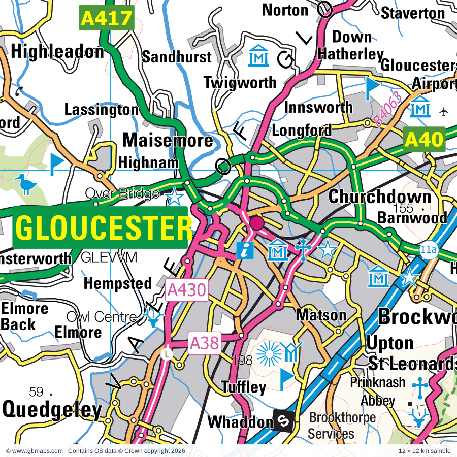
Local authority & parish coverage

Wholly or partly within the full map rectangle. These boundaries are coverage information, not additional artwork layers.

  • Cheltenham DistrictWholly within
  • Cotswold DistrictPartly within
  • County of HerefordshirePartly within
  • Forest of Dean DistrictPartly within
  • Gloucester DistrictWholly within
  • Malvern Hills DistrictPartly within
  • South GloucestershirePartly within
  • Stroud DistrictWholly within
  • SwindonPartly within
  • Tewkesbury DistrictWholly within
  • West Oxfordshire DistrictPartly within
  • WiltshirePartly within
  • Wychavon DistrictPartly within
Wards & electoral divisions 208 areas
  • Abbey Ward
  • Abbeydale Ward
  • Abbeymead Ward
  • All Saints Ward
  • Alvescot and Filkins Ward (part)
  • Amberley and Woodchester Ward
  • Backbury Ward (part)
  • Badbury Park, Eldene & Liden Ward
  • Badgeworth Ward
  • Barnwood Ward
  • Barton & Tredworth Ward
  • Battledown Ward
  • Benhall, the Reddings & Fiddler's Green Ward
  • Berkeley Vale Ward
  • Berry Hill Ward (part)
  • Bisley Ward
  • Blockley Ward (part)
  • Blunsdon Ward
  • Bourton Vale Ward
  • Bourton Village Ward
  • Boyd Valley Ward (part)
  • Bradley Stoke North Ward
  • Bradley Stoke South Ward
  • Bream Ward (part)
  • Bredon Hill Ward (part)
  • Bredon Ward (part)
  • Broadgreen Ward
  • Broadway, Sedgeberrow & Childswickham Ward (part)
  • Brockworth East Ward
  • Brockworth West Ward
  • Cainscross Ward
  • Cam East Ward
  • Cam West Ward
  • Campden & Vale Ward (part)
  • Castlemorton, Welland & Wells Ward (part)
  • Chalford Ward
  • Charfield Ward
  • Charlton & Cribbs Ward (part)
  • Charlton Kings Ward
  • Charlton Park Ward
  • Chedworth & Churn Valley Ward
  • Chesterton Ward
  • Chipping Sodbury & Cotswold Edge Ward (part)
  • Chiseldon & Ridgeway Ward (part)
  • Churchdown Brookfield with Hucclecote Ward
  • Churchdown St. John's Ward
  • Cinderford East Ward
  • Cinderford West Ward
  • Cleeve Grange Ward
  • Cleeve Hill Ward
  • Cleeve St. Michael's Ward
  • Cleeve West Ward
  • Coaley & Uley Ward
  • College Ward
  • Coln Valley Ward (part)
  • Coney Hill Ward
  • Covingham & Nythe Ward
  • Dodington Ward
  • Dursley Ward
  • Dymock Ward
  • Eckington Ward (part)
  • Elmbridge Ward
  • Ermin Ward
  • Fairford North Ward
  • Filton Ward (part)
  • Fosseridge Ward (part)
  • Four Acres Ward
  • Frampton Cotterell Ward (part)
  • Gorse Hill Ward
  • Grange Ward
  • Grumbolds Ash with Avening Ward
  • Hardwicke Ward
  • Hartpury & Redmarley Ward
  • Haydon Wick Ward
  • Hesters Way Ward
  • Highnam with Haw Bridge Ward
  • Highworth Ward (part)
  • Hope End Ward (part)
  • Hucclecote Ward
  • Innsworth Ward
  • Isbourne Ward
  • Kemble Ward
  • Kerne Bridge Ward (part)
  • Kingshill Ward
  • Kingsholm & Wotton Ward
  • Kingsway Ward
  • Kingswood Ward
  • Lansdown Ward
  • Lechlade, Kempsford & Fairford South Ward (part)
  • Leckhampton Ward
  • Ledbury North Ward (part)
  • Ledbury South Ward
  • Ledbury West Ward
  • Longdon Ward
  • Longhope & Huntley Ward
  • Longlevens Ward
  • Lower Stratton Ward
  • Lydbrook Ward (part)
  • Lydiard, Freshbrook & Toothill Ward
  • Lydney East Ward
  • Lydney North Ward
  • Lydney West & Aylburton Ward (part)
  • Matson, Robinswood and White City Ward
  • Minchinhampton Ward
  • Mitcheldean, Ruardean & Drybrook Ward (part)
  • Moreland Ward
  • Moreton West Ward (part)
  • Nailsworth Ward
  • New Mills Ward
  • Newent & Taynton Ward
  • Newnham Ward
  • Northleach Ward (part)
  • Northway Ward
  • Oakley Ward
  • Old Gore Ward (part)
  • Old Town & Lawn Ward
  • Painswick & Upton Ward
  • Park Ward
  • Parks Ward
  • Patchway Coniston Ward (part)
  • Penhill & Pinehurst Ward
  • Penyard Ward
  • Pillowell Ward
  • Pittville Ward
  • Podsmead Ward
  • Prestbury Ward
  • Priory Vale Ward
  • Quedgeley Fieldcourt Ward
  • Quedgeley Severn Vale Ward
  • Queen's Park Ward
  • Randwick, Whiteshill & Ruscombe Ward
  • Rodborough Ward
  • Rodbourne Cheney Ward
  • Rodbourne Ferndale & Western Ward
  • Ross East Ward (part)
  • Ross North Ward (part)
  • Ross West Ward (part)
  • Ruspidge Ward
  • Sandywell Ward
  • Severn Vale North Ward
  • Severn Vale South Ward
  • Severn Vale Ward (part)
  • Severn Ward
  • Shaw & Westlea Ward
  • Shurdington Ward
  • Siddington & Cerney Rural Ward
  • South Cerney Village Ward
  • South Marston Ward (part)
  • Springbank Ward
  • St. Andrews East Ward
  • St. Andrews West & Tadpole Ward
  • St. Briavels Ward (part)
  • St. Mark's Ward
  • St. Michael's Ward
  • St. Paul's Ward
  • St. Peter's Ward
  • Stoke Gifford Ward (part)
  • Stonehouse Ward
  • Stow Ward (part)
  • Stratton Ward
  • Stroud Central Ward
  • Stroud Farmhill & Paganhill Ward
  • Stroud Slade Ward
  • Stroud Trinity Ward
  • Stroud Uplands Ward
  • Stroud Valley Ward
  • Swindon Village Ward
  • Tetbury East & Rural Ward
  • Tetbury Town Ward
  • Tetbury with Upton Ward
  • Tewkesbury East Ward
  • Tewkesbury North & Twyning Ward
  • Tewkesbury South Ward
  • The Ampneys & Hampton Ward
  • The Beeches Ward
  • The Rissingtons Ward (part)
  • The Stanleys Ward
  • Thornbury Ward
  • Three Crosses Ward (part)
  • Thrupp Ward
  • Tidenham Ward (part)
  • Tuffley Ward
  • Up Hatherley Ward
  • Upper Stratton Ward
  • Upton & Ripple Ward (part)
  • Walcot Ward
  • Warden Hill Ward
  • Watermoor Ward
  • Westbury-on-Severn Ward
  • Westgate Ward
  • Winchcombe Ward
  • Winterbourne Ward (part)
  • Wotton-under-Edge Ward
  • Wroughton & Wichelstowe Ward (part)
  • Yate Central Ward
  • Yate North Ward
  • Brinkworth ED (part)
  • By Brook ED (part)
  • Cricklade & Latton ED
  • Kington ED (part)
  • Lyneham ED (part)
  • Malmesbury ED
  • Minety ED
  • Purton ED
  • Royal Wootton Bassett East ED (part)
  • Royal Wootton Bassett North ED
  • Royal Wootton Bassett South & West ED (part)
  • Sherston ED
Civil parishes & communities 403 areas
  • Acton Turville CP (part)
  • Alderley CP
  • Alderton CP
  • Aldsworth CP
  • Alkington CP
  • Almondsbury CP (part)
  • Alveston CP
  • Alvington CP (part)
  • Ampney Crucis CP
  • Ampney St. Mary CP
  • Ampney St. Peter CP
  • Andoversford CP
  • Arlingham CP
  • Ashchurch Rural CP
  • Ashleworth CP
  • Ashley CP
  • Ashton Keynes CP
  • Ashton under Hill CP
  • Aston Ingham CP
  • Aston Somerville CP
  • Aust CP (part)
  • Avening CP
  • Awre CP
  • Aylburton CP (part)
  • Aylton CP
  • Badgeworth CP
  • Badminton CP
  • Bagendon CP
  • Barnsley CP
  • Barrington CP (part)
  • Batsford CP (part)
  • Baunton CP
  • Beckford CP
  • Berkeley CP
  • Berrow CP
  • Beverston CP
  • Bibury CP
  • Birdlip CP
  • Birtsmorton CP
  • Bishop's Cleeve CP
  • Bisley-with-Lypiatt CP
  • Blaisdon CP
  • Blockley CP (part)
  • Blunsdon CP
  • Boddington CP
  • Bourton-on-the-Hill CP (part)
  • Bourton-on-the-Water CP
  • Boxwell with Leighterton CP
  • Bradley Stoke CP
  • Brampton Abbotts CP (part)
  • Braydon CP
  • Bredon CP
  • Bredon's Norton CP (part)
  • Brimpsfield CP
  • Brimscombe and Thrupp CP
  • Brinkworth CP
  • Broad Town CP (part)
  • Broadway CP (part)
  • Broadwell CP (part)
  • Brockhampton CP (part)
  • Brockworth CP
  • Brokenborough CP
  • Bromesberrow CP
  • Brookthorpe-with-Whaddon CP
  • Buckland CP
  • Bushley CP
  • Cainscross CP
  • Cam CP
  • Castle Eaton CP
  • Castlemorton CP
  • Central Swindon North CP
  • Chaceley CP
  • Chalford CP
  • Charfield CP
  • Charlton CP
  • Charlton Hayes CP (part)
  • Charlton Kings CP
  • Chedworth CP
  • Cherington CP
  • Childswickham CP (part)
  • Chipping Campden CP (part)
  • Chiseldon CP (part)
  • Christian Malford CP (part)
  • Churcham CP
  • Churchdown CP
  • Cinderford CP
  • Cirencester CP
  • Clapton CP
  • Coaley CP
  • Coates CP
  • Coberley CP
  • Cold Aston CP
  • Colesbourne CP
  • Coln St. Aldwyns CP
  • Coln St. Dennis CP
  • Colwall CP (part)
  • Compton Abdale CP
  • Conderton CP
  • Condicote CP
  • Corse CP
  • Covingham CP
  • Cowley CP
  • Cranham CP
  • Cricklade CP
  • Cromhall CP
  • Crudwell CP
  • Cutsdean CP
  • Daglingworth CP
  • Dauntsey CP (part)
  • Deerhurst CP
  • Didmarton CP
  • Dodington CP (part)
  • Donnington CP (part)
  • Donnington CP
  • Dormington CP (part)
  • Dowdeswell CP
  • Down Ampney CP
  • Down Hatherley CP
  • Driffield CP
  • Drybrook CP
  • Dumbleton CP
  • Duntisbourne Abbots CP
  • Duntisbourne Rouse CP
  • Dursley CP
  • Dymock CP
  • Eastington CP
  • Eastleach CP (part)
  • Eastnor CP
  • Easton Grey CP
  • Ebrington CP (part)
  • Eckington CP (part)
  • Edgeworth CP
  • Eldersfield CP
  • Elkstone CP
  • Elmley Castle CP (part)
  • Elmore CP
  • Elmstone Hardwicke CP
  • English Bicknor CP (part)
  • Fairford CP
  • Falfield CP
  • Farmington CP
  • Filton CP (part)
  • Forthampton CP
  • Fownhope CP (part)
  • Foy CP (part)
  • Frampton Cotterell CP
  • Frampton on Severn CP
  • Fretherne with Saul CP
  • Frocester CP
  • Gorsley and Kilcot CP
  • Gotherington CP
  • Great Oldbury CP
  • Great Rissington CP (part)
  • Great Somerford CP
  • Great Witcombe CP
  • Gretton CP
  • Grittleton CP (part)
  • Guiting Power CP
  • Ham and Stone CP
  • Hamfallow CP
  • Hampnett CP
  • Hankerton CP
  • Hannington CP
  • Hardwicke CP
  • Harescombe CP
  • Haresfield CP
  • Hartpury CP
  • Hasfield CP
  • Hatherop CP
  • Hawkesbury CP
  • Hawling CP
  • Haydon Wick CP
  • Hazleton CP
  • Highnam CP
  • Highworth CP (part)
  • Hill CP
  • Hillesley and Tresham CP
  • Hinton CP
  • Hinton on the Green CP (part)
  • Holdfast CP
  • Hope Mansell CP
  • Horsley CP
  • Horton CP
  • How Caple CP (part)
  • Hucclecote CP
  • Hullavington CP
  • Huntley CP
  • Hunts Grove CP
  • Icomb CP (part)
  • Inglesham CP (part)
  • Innsworth CP
  • Iron Acton CP
  • Kemble and Ewen CP
  • Kemerton CP (part)
  • Kempley CP
  • Kempsford CP (part)
  • King's Stanley CP
  • Kingscote CP
  • Kingswood CP
  • Latton CP
  • Lea CP
  • Lea and Cleverton CP
  • Lechlade CP (part)
  • Leckhampton with Warden Hill CP
  • Ledbury CP (part)
  • Leigh CP
  • Leigh CP
  • Leonard Stanley CP
  • Liddington CP (part)
  • Linton CP
  • Little Malvern CP (part)
  • Little Marcle CP
  • Little Rissington CP (part)
  • Little Somerford CP
  • Littledean CP
  • Long Newnton CP
  • Longborough CP (part)
  • Longdon CP
  • Longford CP
  • Longhope CP
  • Longney and Epney CP
  • Lower Slaughter CP
  • Luckington CP
  • Lydbrook CP (part)
  • Lydiard Millicent CP
  • Lydiard Tregoze CP (part)
  • Lydney CP
  • Lyneham and Bradenstoke CP (part)
  • Maisemore CP
  • Maiseyhampton CP
  • Malmesbury CP
  • Marston Maisey CP
  • Maugersbury CP (part)
  • Minchinhampton CP
  • Minety CP
  • Minsterworth CP
  • Miserden CP
  • Mitcheldean CP
  • Mordiford CP (part)
  • Moreton Valence CP
  • Moreton-in-Marsh CP (part)
  • Much Marcle CP
  • Munsley CP (part)
  • Nailsworth CP
  • Naunton CP
  • Nettleton CP (part)
  • Newent CP
  • Newnham CP
  • North Cerney CP
  • North Nibley CP
  • Northleach with Eastington CP
  • Northway CP
  • Norton CP
  • Norton CP
  • Notgrove CP
  • Nympsfield CP
  • Nythe, Eldene and Liden CP
  • Oaksey CP
  • Oldbury-upon-Severn CP (part)
  • Olveston CP (part)
  • Overbury CP (part)
  • Owlpen CP
  • Oxenhall CP
  • Oxenton CP
  • Ozleworth CP
  • Painswick CP
  • Patchway CP (part)
  • Pauntley CP
  • Pendock CP
  • Pitchcombe CP
  • Pixley CP (part)
  • Poole Keynes CP
  • Poulton CP
  • Prescott CP
  • Prestbury CP
  • Preston CP
  • Purton CP
  • Putley CP
  • Quedgeley CP
  • Queenhill CP
  • Quenington CP
  • Randwick and Westrip CP
  • Rangeworthy CP
  • Redmarley D'abitot CP
  • Rendcomb CP
  • Ripple CP (part)
  • Rockhampton CP
  • Rodborough CP
  • Rodmarton CP
  • Ross-on-Wye CP (part)
  • Royal Wootton Bassett CP (part)
  • Ruardean CP (part)
  • Rudford and Highleadon CP
  • Ruspidge and Soudley CP
  • Saintbury CP (part)
  • Sandhurst CP
  • Sapperton CP
  • Seagry CP (part)
  • Sedgeberrow CP
  • Sevenhampton CP
  • Sezincote CP (part)
  • Sherborne CP
  • Sherston CP
  • Shipton CP
  • Shipton Moyne CP
  • Shurdington CP
  • Siddington CP
  • Slimbridge CP
  • Snowshill CP
  • Sodbury CP
  • Sollers Hope CP
  • Somerford Keynes CP
  • Sopworth CP
  • South Cerney CP
  • South Marston CP (part)
  • South Swindon CP
  • Southam CP
  • Southrop CP (part)
  • St. Andrews CP
  • St. Paul Malmesbury Without CP
  • Standish CP
  • Stanton CP
  • Stanton Fitzwarren CP
  • Stanton St. Quintin CP (part)
  • Stanway CP
  • Staunton CP
  • Staverton CP
  • Stinchcombe CP
  • Stoke Edith CP (part)
  • Stoke Gifford CP (part)
  • Stoke Lodge and The Common CP
  • Stoke Orchard CP
  • Stonehouse CP
  • Stow-on-the-Wold CP (part)
  • Stratton St. Margaret CP
  • Strensham CP (part)
  • Stroud CP
  • Sudeley CP
  • Swell CP
  • Swindon CP
  • Syde CP
  • Tarrington CP (part)
  • Taynton CP
  • Teddington CP
  • Temple Guiting CP
  • Tetbury CP
  • Tetbury Upton CP
  • Tewkesbury CP
  • Thornbury CP
  • Tibberton CP
  • Tirley CP
  • Tockenham CP (part)
  • Toddington CP
  • Tormarton CP (part)
  • Tortworth CP
  • Turkdean CP
  • Twigworth CP
  • Twyning CP
  • Tytherington and Itchington CP
  • Uckington CP
  • Uley CP
  • Up Hatherley CP
  • Upleadon CP
  • Upper Slaughter CP
  • Upton Bishop CP
  • Upton St. Leonards CP
  • Upton-upon-Severn CP (part)
  • Walford CP (part)
  • Wanborough CP (part)
  • Welland CP (part)
  • Wellington Heath CP (part)
  • Welsh Bicknor CP (part)
  • West Dean CP (part)
  • West Swindon CP
  • Westbury-on-Severn CP
  • Westerleigh and Coalpit Heath CP (part)
  • Weston Subedge CP (part)
  • Weston under Penyard CP
  • Westonbirt with Lasborough CP
  • Westwell CP (part)
  • Wheatpieces CP
  • Whiteshill and Ruscombe CP
  • Whitminster CP
  • Whittington CP
  • Wick Rissington CP (part)
  • Wickwar CP
  • Willersey CP (part)
  • Winchcombe CP
  • Windrush CP (part)
  • Winson CP
  • Winstone CP
  • Winterbourne CP (part)
  • Withington CP
  • Woodchester CP
  • Woodmancote CP
  • Woolaston CP (part)
  • Woolhope CP (part)
  • Wormington CP
  • Wotton-under-Edge CP
  • Wroughton CP (part)
  • Yanworth CP
  • Yate CP
  • Yatton CP

Source: the GBMaps road atlas, OS Boundary-Line and postcode mapping datasets. Source editions are being checked for publication. Unmarked boundary names are wholly within the sheet; “part” means the map edge crosses the area.

Place lists are selected from the map source, not a complete gazetteer. Named features describe the cartography; visitor facilities and opening status are not verified. The free sample covers only 12 × 12 km of this larger sheet.

INSIDE YOUR DOWNLOAD

A proper road map, in useful formats

Road classifications, towns and villages, railways, rivers, landscape detail and tourist symbols, brought together in the GBMaps regional road atlas style.

PDF filePDFSVG fileSVGAdobe Illustrator AI fileAi

PDF for the finished map. SVG and layered Illustrator artwork for adapting colours, adding your own information and preparing designs.

THE FINISHED SHEET

Designed for print and presentation

Map coverage
60 × 60 km
Sample coverage
12 × 12 km
Print layout
A3 landscape · enlarged 1:250k cartography
Sheet furniture
Border, scale bar, key & north arrow

A few useful details

What changes when I select another square?

Select a surrounding square to bring it into the centre and reveal the maps around it. Each square is a different 60 × 60 km map. The preview, free sample and selected download change together. Neighbouring sheets overlap by 30 km so you can choose the coverage that suits you.

Is the free sample a vector map?

The on-page detail is an SVG. The free download is a separate 12 × 12 km PDF with a link to the full map. Please retain its copyright credits and product link when sharing it.

Can I buy a larger combined map?

These downloads are individual ready-made sheets. Contact GBMaps if you need a larger combined area.

FREE PDF SAMPLE

Your free map sample

Your free 12 × 12 km sample includes a link back to this map, so you can return for the full area whenever you need it.

Download free PDF sample ↓

Get your Gloucester map

Map download bundle

£24.00including VATOne payment

Pay securely

One payment. Your map stays open.

Your map download

Your map files

Preparing your download…

Checking your private download link…

Your map downloads

Already bought a map?

Find the downloads from your purchases.

Enter the email address you used at checkout. We’ll email you a private link to your available map downloads.