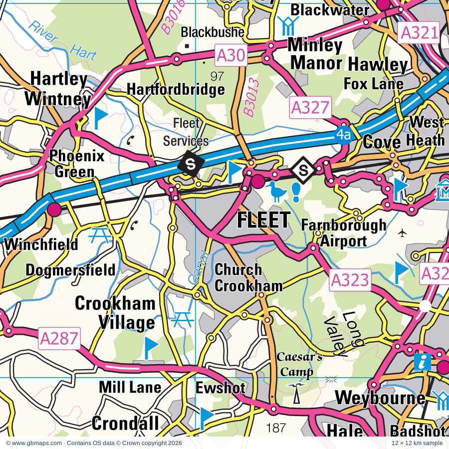
Fleet regional road map. Full 60 × 60 km PDF, SVG and Illustrator files, with a free PDF sample.

GBMAPS.COM

Fleet Regional Road Map

Call Us Now for Help01751 473136

GREAT BRITAIN ROAD ATLAS · 1:250,000 GB-480-0150

Fleet & surrounding area

Explore the full 60 × 60 km Fleet regional road map at 1:250,000, covering Fleet, Farnham, Aldershot, Farnborough, Yateley. Compare the complete coverage below; a detailed PDF sample is available free.

FLEET & SURROUNDING AREAREGIONAL ROAD MAP
60 × 60 km · Full map previewDownload the free SVG ↓

INSIDE THE FULL 60 × 60 KM MAP

Explore the Fleet map area

1:250,000 cartography

Towns, villages & places

More mapped places (319)

Roads across this sheet

M3, M4, M25, A3, A4, A25, A29, A30, A31, A32, A33, A244, A245, A246, A247, A248, A264, A272, A281, A283, A285, A286, A287, A308

More road numbers

A308(M), A312, A315, A317, A318, A319, A320, A321, A322, A323, A324, A325, A327, A328, A329, A329(M), A330, A331, A332, A333, A339, A340, A355, A404(M), A408, A412, A437, A3010, A3011, A3013, A3016, A3032, A3044, A3046, A3050, A3095, A3100, A3290, A4074, A4155, B311, B365, B367, B368, B372, B373, B374, B375, B376, B377, B378, B380, B381, B382, B383, B385, B386, B387, B388, B389, B470, B471, B477, B478, B481, B2039, B2070, B2126, B2127, B2128, B2130, B2131, B2133, B2146, B2177, B2199, B2215, B2234, B3000, B3001, B3002, B3003, B3004, B3005, B3006, B3007, B3008, B3010, B3011, B3012, B3013, B3014, B3015, B3016, B3017, B3018, B3020, B3021, B3022, B3024, B3025, B3026, B3027, B3028, B3029, B3030, B3031, B3032, B3034, B3035, B3046, B3047, B3051, B3121, B3165, B3166, B3175, B3206, B3208, B3270, B3272, B3345, B3348, B3349, B3350, B3366, B3367, B3376, B3377, B3383, B3384, B3400, B3403, B3404, B3405, B3407, B3408, B3411, B3430, B4009, B4446, B4526

Rivers & waterways

Basingstoke Canal, Blackwater River, Colne Brook, Colne River, Desborough Channel, Fray's River, Grand Union Canal, Grand Union Canal (Slough Arm), Holy Brook, Jubilee River, Kennet & Avon Canal, Poyle Channel

More waterways

River Arun, River Colne, River Hart, River Itchen, River Kennet, River Loddon, River Meon, River Mole, River Pang, River Rother, River Slea, River Test, River Thames, River Wey, River Wey Navigation, River Whitewater, Wey & Arun Canal, Wraysbury River

Landmarks & landscape

21 South Street Arts Centre, 4 Kingdoms Adventure Park, Aldermaston Wharf Canal Visitor Centre, Aldershot Military Museum, Army Physical Training Corps Museum, Airborne Forces Museum, Alice Holt Woodland Park Forest Centre, Go Ape Alice Holt, Allen Gallery & Curtis Museum, Ascot Racecourse, Avington Park, Ballards Brewery, Basildon House and Park, Basing House, Basingstoke Canal Visitor Centre, SOUTH DOWNS NATIONAL PARK

More named features

Beale Park Wildlife Park, Bedfont Lakes Country Park, Birdworld, Blackbushe, Braywick Park and Nature Centre, Brickfields Country Park, Brooklands Motoring and Aviation Museum, Mercedes Benz World, Bucklebury Common Nature Reserve, Bucklebury Farm Park, CALLEVA, California Country Park, Calleva Museum, Calleva Roman Town Wall, Calleva Roman Town Amphitheatre, Chertsey Museum, Chilworth Manor, Chobham Common National Nature Reserve, Chreode Pottery, Clandon Park, Cobham Bus Museum, Cowdray, Cowdray Heritage Trust, Cranleigh Arts Centre, Dapdune Wharf, Datchet Watersports, Dinton Pastures Country Park, Dorney Court, Egham Museum, Elmbridge Museum, Englefield Garden, Eton College and Small Museum, Farnborough Air Sciences Trust, Farnham Castle, Farnham Museum, Fishers Farm Park, Fleet Pond Nature Reserve, Frimley Hatches Nature Reserve, Godalming Museum, Great Cockcrow Railway, Guildford, Guildford Cathedral, Guildford Museum, The Undercroft, Haslemere Educational Museum, Hatchlands, Hatchlands Park, Heathland Visitor Centre, Hinton Ampner, Hinton Ampner Garden, Hinton Ampner House, Hogs Back Brewery, Hollycombe Steam Collection, Holme Grange, Horsell Common Nature Walks Nature Reserve, Intech Science Centre, Iping & Stedham Commons Nature Reserve, Itchen Abbas Roman Villa, Itchen Valley Brewery, James Hockey Gallery and Foyer Gallery, Jane Austen's House Museum, Legoland Windsor, Lightwater Country Park, Lockwood Donkey Sanctuary, Lookout Discovery Centre, Go Ape Bracknell, Loseley House, Loseley House and Garden, Lurgashall Winery, Mapledurham House, Mapledurham Watermill, Marwell Wildlife, Meon Pottery, Mid Hants Railway, Milestones Living History Museum, Museum of Berkshire Aviation, Museum of Reading, Blakes Lock Museum, Museum of English Rural Life, National Shooting Centre, Noar Hill Nature Reserve, Odiham Castle, Old Winchester Hill Nature Reserve, Painshill Landscape Garden, Petersfield Museum, Petworth Cottage Museum, Petworth Deer Park, Petworth House, Pierces Solar Farm, Priory, R.E.M.E Museum, RAMC Museum, Riverhouse (The Robert Phillips Gallery), Roman Villa (site of), Rowing Centre, Royal Horticultural Society Garden, Royal Logistic Corps Museum, Runnymede, Rural Life Centre Museum, Second World War Aircraft Preservation Society, Selborne Hill Nature Reserve, Shere Museum, Shortheath Common Nature Reserve, Slough Museum, Spelthorne Museum, Steventon Pottery, Stratfield Saye House, Surrey Heath Museum, Surrey History Centre, Tank Driving Experience, Thatcham Reed Beds, The Grange, The Lightbox, The Living Rainforest, The Long Walk, The Oates Museum/Gilberts Whites House, The Pottery, The Savill Gardens, The Vyne, The Witley Centre, Thorpe Park Theme Park, Trilakes Country Park, Valley Gardens, Valley Vineyards, Virginia Water, Wakeners or Waggoners Wells Beauty Spot, Waverly Abbey (remains of), Wellington Country Park, West Clandon Dragon, West Green House Garden, Whitehill Lane Solar Farm, Wildmoor Heath Nature Reserve, Willis Museum, Windsor Castle, Windsor Great Park Nature Reserve, Windsor Racecourse, Winkworth Arboretum, Witley & Milford Commons Nature Reserve, Yateley Common Country Park

Local authority & parish coverage

Wholly or partly within the full map rectangle. These boundaries are coverage information, not additional artwork layers.

  • Basingstoke and Deane DistrictPartly within
  • Bracknell ForestWholly within
  • BuckinghamshirePartly within
  • Chichester DistrictPartly within
  • East Hampshire DistrictPartly within
  • Eastleigh DistrictPartly within
  • Elmbridge DistrictPartly within
  • Guildford DistrictPartly within
  • Hart DistrictWholly within
  • Hillingdon London BoroPartly within
  • Horsham DistrictPartly within
  • Hounslow London BoroPartly within
  • Mole Valley DistrictPartly within
  • ReadingWholly within
  • Runnymede DistrictWholly within
  • Rushmoor DistrictWholly within
  • SloughPartly within
  • South Oxfordshire DistrictPartly within
  • Spelthorne DistrictPartly within
  • Surrey Heath DistrictWholly within
  • Waverley DistrictPartly within
  • West BerkshirePartly within
  • Winchester DistrictPartly within
  • Windsor and MaidenheadPartly within
  • Woking DistrictWholly within
  • WokinghamPartly within
Wards & electoral divisions 297 areas
  • Abbey Ward
  • Addlestone North Ward
  • Addlestone South Ward
  • Aldermaston Ward
  • Aldershot Park Ward
  • Alfold, Dunsfold & Hascombe Ward
  • Alresford & Itchen Valley Ward (part)
  • Alton Amery Ward
  • Alton Ashdell Ward
  • Alton Eastbrooke Ward
  • Alton Holybourne Ward
  • Alton Westbrooke Ward
  • Alton Whitedown Ward
  • Alton Wooteys Ward
  • Ascot & Sunninghill Ward
  • Ash South Ward
  • Ash Vale Ward
  • Ash Wharf Ward
  • Ashford Common Ward
  • Ashford East Ward
  • Ashford North and Stanwell South Ward
  • Ashford Town Ward
  • Bagshot Ward
  • Barkham & Arborfield Ward
  • Basildon Ward (part)
  • Basing & Upton Grey Ward
  • Battle Ward
  • Bedfont Ward (part)
  • Bellfields & Slyfield Ward
  • Bentworth & Froyle Ward
  • Billingshurst Ward (part)
  • Binfield North & Warfield West Ward
  • Binfield South & Jennett's Park Ward
  • Binsted, Bentley & Selborne Ward
  • Bishop's Waltham Ward (part)
  • Bisley & West End Ward (DET)
  • Blackwater and Hawley Ward
  • Boyn Hill Ward (part)
  • Bradfield Ward
  • Bramley & Wonersh Ward
  • Bramley Ward
  • Bramshott & Liphook Ward
  • Bray Ward
  • Brighton Hill Ward
  • Brookvale & Kings Furlong Ward
  • Bucklebury Ward
  • Bullbrook Ward
  • Bulmershe & Coronation Ward
  • Burghfield & Mortimer Ward
  • Buriton & East Meon Ward (part)
  • Burnham Ward (part)
  • Burpham Ward
  • Byfleet & West Byfleet Ward
  • Canalside Ward
  • Castle Ward
  • Caversham Heights Ward
  • Caversham Ward
  • Central Meon Valley Ward (part)
  • Chalvey Ward (part)
  • Cherrywood Ward
  • Chertsey Riverside Ward
  • Chertsey St. Ann's Ward
  • Chiddingfold Ward
  • Chieveley & Cold Ash Ward (part)
  • Chineham Ward
  • Church Ward
  • Cippenham Manor Ward (part)
  • Cippenham Village Ward (part)
  • Clandon & Horsley Ward (part)
  • Clewer & Dedworth East Ward
  • Clewer & Dedworth West Ward
  • Clewer East Ward
  • Cobham & Downside Ward (part)
  • Colden Common & Twyford Ward (part)
  • Coley Ward
  • Colnbrook & Poyle Ward
  • Cove and Southwood Ward
  • Cox Green Ward (part)
  • Cranleigh East Ward
  • Cranleigh West Ward
  • Crookham East Ward
  • Crookham West and Ewshot Ward
  • Crowthorne Ward
  • Datchet, Horton & Wraysbury Ward
  • Easebourne Ward (part)
  • Easthampstead & Wildridings Ward
  • Eastrop & Grove Ward
  • Egham Hythe Ward
  • Egham Town Ward
  • Elstead & Peper Harow Ward
  • Emmbrook Ward
  • Emmer Green Ward
  • Empress Ward
  • Englefield Green East Ward
  • Englefield Green West Ward
  • Eton & Castle Ward
  • Evendons Ward
  • Evingar Ward (part)
  • Ewhurst & Ellens Green Ward (part)
  • Fair Oak & Horton Heath Ward (part)
  • Farnham Bourne Ward
  • Farnham Castle Ward
  • Farnham Firgrove Ward
  • Farnham Heath End Ward
  • Farnham Moor Park Ward
  • Farnham North West Ward
  • Farnham Rowledge Ward
  • Farnham Weybourne Ward
  • Farnhams & Stoke Poges Ward (part)
  • Feltham North Ward (part)
  • Feltham West Ward (part)
  • Fernhill Ward
  • Fernhurst Ward
  • Finchampstead Ward
  • Fittleworth Ward (part)
  • Fleet Central Ward
  • Fleet East Ward
  • Fleet West Ward
  • Four Marks & Medstead Ward
  • Frimley Green Ward
  • Frimley Ward
  • Froxfield, Sheet & Steep Ward
  • Godalming Binscombe & Charterhouse Ward
  • Godalming Central & Ockford Ward
  • Godalming Farncombe & Catteshall Ward
  • Godalming Holloway Ward
  • Goldsworth Park Ward
  • Goring Ward (part)
  • Grayshott Ward
  • Great Hollands Ward
  • Halliford and Sunbury West Ward (part)
  • Hanworth Park Ward (part)
  • Hanworth Ward
  • Harmans Water & Crown Wood Ward
  • Harting Ward (part)
  • Hartley Wintney Ward
  • Haslemere East Ward
  • Haslemere West Ward
  • Hatch Warren & Beggarwood Ward
  • Hawkedon Ward
  • Hayes Town Ward (part)
  • Headley Ward
  • Heatherside Ward
  • Heathlands Ward
  • Heathrow Villages Ward (part)
  • Herschel Park Ward
  • Hersham Village Ward (part)
  • Hillside Ward
  • Hindhead & Beacon Hill Ward
  • Hoe Valley Ward
  • Hook Ward
  • Horsell Ward
  • Hurley & Walthams Ward (part)
  • Itchingfield, Slinfold & Warnham Ward (part)
  • Iver Ward (part)
  • Katesgrove Ward
  • Kempshott & Buckskin Ward
  • Kentwood Ward
  • Kidmore End & Whitchurch Ward (part)
  • Knaphill Ward
  • Knellwood Ward
  • Laleham and Shepperton Green Ward
  • Langley Foxborough Ward
  • Langley Marish Ward
  • Langley Meads Ward (part)
  • Langley St. Mary's Ward (part)
  • Lightwater Ward
  • Lindford Ward
  • Liss Ward
  • Loddon Ward
  • Longcross, Lyne & Chertsey South Ward
  • Loxwood Ward
  • Maiden Erlegh & Whitegates Ward
  • Manor Park Ward
  • Merrow Ward
  • Mickleham, Westcott & Okewood Ward (part)
  • Midhurst Ward (part)
  • Milford & Witley Ward
  • Mount Hermon Ward
  • Mytchett & Deepcut Ward
  • New Haw Ward
  • Newbury Greenham Ward (part)
  • Norcot Ward
  • Norden Ward
  • Normandy & Pirbright Ward
  • Norreys Ward
  • North Town Ward
  • Oakley & The Candovers Ward
  • Oatlands & Burwood Park Ward (part)
  • Odiham Ward
  • Old Dean Ward
  • Old Windsor Ward
  • Oldfield Ward (part)
  • Onslow Ward
  • Ottershaw Ward
  • Owlsmoor & College Town Ward
  • Pangbourne Ward
  • Park Ward
  • Parkside Ward
  • Petersfield Bell Hill Ward
  • Petersfield Causeway Ward
  • Petersfield Heath Ward
  • Petersfield St. Peter's Ward
  • Petworth Ward (part)
  • Pilgrims Ward
  • Pinkwell Ward (part)
  • Popley Ward
  • Priestwood & Garth Ward
  • Pulborough, Coldwaltham & Amberley Ward (part)
  • Pyrford Ward
  • Redlands Ward
  • Ridgeway Ward (part)
  • Riverside and Laleham Ward
  • Ropley, Hawkley & Hangers Ward
  • Rowhill Ward
  • Rudgwick Ward (part)
  • Sandhurst Ward
  • Send & Lovelace Ward (part)
  • Shalford Ward
  • Shepperton Town Ward (part)
  • Sherborne St. John & Rooksdown Ward
  • Shinfield Ward
  • Slough Central Ward (part)
  • Sonning Common Ward (part)
  • South Ham Ward
  • South Lake Ward
  • Southcote Ward
  • Spencers Wood & Swallowfield Ward
  • St. Bartholomew Ward (part)
  • St. John's Ward
  • St. John's Ward
  • St. Mark's Ward
  • St. Michaels Ward
  • St. Nicolas Ward
  • St. Pauls Ward
  • Staines South Ward
  • Staines Ward
  • Stanwell North Ward
  • Stoke Ward
  • Stoughton North Ward
  • Stoughton South Ward
  • Sunbury Common Ward (part)
  • Sunbury East Ward (part)
  • Sunningdale & Cheapside Ward
  • Swinley Forest Ward
  • Tadley & Pamber Ward
  • Tadley North, Kingsclere & Baughurst Ward (part)
  • Thames Ward
  • Thames Ward (part)
  • Thatcham Central Ward
  • Thatcham Colthrop & Crookham Ward (part)
  • Thatcham North East Ward
  • Thatcham West Ward (part)
  • The Worthys Ward (part)
  • Theale Ward
  • Thorpe Ward
  • Tilehurst & Purley Ward
  • Tilehurst Birch Copse Ward
  • Tilehurst South & Holybrook Ward
  • Tilehurst Ward
  • Tillingbourne Ward (part)
  • Town Centre & The Parks Ward
  • Town Ward
  • Twyford, Ruscombe & Hurst Ward
  • Upper Meon Valley Ward (part)
  • Upton Lea Ward (part)
  • Upton Ward
  • Virginia Water Ward
  • Walton Central Ward (part)
  • Walton South Ward (part)
  • Watchetts Ward
  • Wellington Ward
  • Wescott Ward
  • West Chiltington, Thakeham & Ashington Ward (part)
  • West Drayton Ward (part)
  • West Heath Ward
  • Westborough Ward
  • Western Commons Ward
  • Weybridge Riverside Ward
  • Weybridge St. George's Hill Ward (part)
  • Whitchurch, Overton & Laverstoke Ward (part)
  • Whitegrove Ward
  • Whitehill Chase Ward
  • Whitehill Hogmoor & Greatham Ward
  • Whitehill Pinewood Ward
  • Whitley Ward
  • Windlesham & Chobham Ward
  • Winkfield & Warfield East Ward
  • Winklebury & Manydown Ward
  • Winnersh Ward
  • Wokingham Without Ward
  • Wonston & Micheldever Ward (part)
  • Woodham & Rowtown Ward
  • Worplesdon Ward
  • Yateley East Ward
  • Yateley West Ward
  • Yiewsley Ward (part)
Civil parishes & communities 304 areas
  • Abinger CP (part)
  • Albury CP
  • Aldermaston CP
  • Aldworth CP (part)
  • Alfold CP
  • Alton CP
  • Arborfield and Newland CP
  • Artington CP
  • Ash CP
  • Ashampstead CP
  • Ashford Hill with Headley CP
  • Barkham CP
  • Basildon CP
  • Baughurst CP
  • Beauworth CP
  • Beech CP
  • Beech Hill CP
  • Beenham CP
  • Bentley CP
  • Bentworth CP
  • Bepton CP (part)
  • Bighton CP
  • Billingshurst CP (part)
  • Binfield CP
  • Binfield Heath CP (part)
  • Binsted CP
  • Bishops Sutton CP
  • Bishops Waltham CP (part)
  • Bisley CP (DET)
  • Blackwater and Hawley CP
  • Bracknell CP
  • Bradfield CP
  • Bradley CP
  • Bramdean and Hinton Ampner CP
  • Bramley CP
  • Bramley CP
  • Bramshill CP
  • Bramshott and Liphook CP
  • Bray CP (part)
  • Brimpton CP
  • Bucklebury CP
  • Burghfield CP
  • Buriton CP (part)
  • Burnham CP (part)
  • Candovers CP
  • Charvil CP
  • Chawton CP
  • Cheriton CP
  • Chiddingfold CP
  • Chieveley CP (part)
  • Chilcomb CP (part)
  • Chineham CP
  • Chobham CP
  • Church Crookham CP
  • Churt CP
  • Cliddesden CP
  • Cocking CP (part)
  • Cold Ash CP (part)
  • Colden Common CP (part)
  • Colemore and Priors Dean CP
  • Colnbrook with Poyle CP
  • Compton CP
  • Compton CP (part)
  • Corhampton and Meonstoke CP (part)
  • Cox Green CP (part)
  • Cranleigh CP
  • Crondall CP
  • Crookham Village CP
  • Crowthorne CP
  • Datchet CP
  • Deane CP
  • Dockenfield CP
  • Dogmersfield CP
  • Dorney CP (part)
  • Droxford CP (part)
  • Dummer CP
  • Duncton CP (part)
  • Dunsfold CP
  • Earley CP
  • Easebourne CP (part)
  • East Clandon CP
  • East Horsley CP (part)
  • East Ilsley CP (part)
  • East Lavington CP (part)
  • East Meon CP (part)
  • East Tisted CP
  • Ebernoe CP
  • Ecchinswell, Sydmonton and Bishops Green CP (part)
  • Ellisfield CP
  • Elstead CP
  • Elsted and Treyford CP (part)
  • Elvetham Heath CP
  • Englefield CP
  • Eton CP
  • Eversley CP
  • Ewhurst CP (part)
  • Ewshot CP
  • Exton CP
  • Eye and Dunsden CP
  • Fair Oak and Horton Heath CP (part)
  • Farleigh Wallop CP
  • Farnham CP
  • Farringdon CP
  • Fernhurst CP
  • Finchampstead CP
  • Fittleworth CP (part)
  • Fleet CP
  • Four Marks CP
  • Frensham CP
  • Frilsham CP
  • Froxfield and Privett CP
  • Froyle CP
  • Godalming CP
  • Goring Heath CP (part)
  • Goring-on-Thames CP (part)
  • Graffham CP (part)
  • Grayshott CP
  • Greatham CP
  • Greenham CP (part)
  • Greywell CP
  • Hambledon CP (part)
  • Hambledon CP
  • Hampstead Norreys CP (part)
  • Hannington CP
  • Harpsden CP (part)
  • Harting CP (part)
  • Hartley Wespall CP
  • Hartley Wintney CP
  • Hascombe CP
  • Haslemere CP
  • Hawkley CP
  • Headley CP
  • Heckfield CP
  • Hermitage CP
  • Herriard CP
  • Heyshott CP (part)
  • Holybrook CP
  • Hook CP
  • Horton CP
  • Hurley CP (part)
  • Itchen Stoke and Ovington CP
  • Itchen Valley CP (part)
  • Iver CP (part)
  • Kidmore End CP (part)
  • Kilmiston CP
  • Kings Worthy CP (part)
  • Kingsclere CP (part)
  • Kingsley CP
  • Kirdford CP
  • Langrish CP
  • Lasham CP
  • Laverstoke CP (part)
  • Linch CP
  • Linchmere CP
  • Lindford CP
  • Liss CP
  • Lodsworth CP (part)
  • Long Sutton CP
  • Loxwood CP
  • Lurgashall CP
  • Mapledurham CP
  • Mapledurwell and Up Nately CP
  • Mattingley CP
  • Medstead CP
  • Micheldever CP (part)
  • Midgham CP
  • Midhurst CP (part)
  • Milland CP
  • Monk Sherborne CP
  • Mortimer West End CP
  • Munstead and Tuesley CP
  • New Alresford CP
  • Newnham CP
  • Newton Valence CP
  • Normandy CP
  • North Waltham CP
  • Northchapel CP
  • Northington CP
  • Nutley CP
  • Oakley CP
  • Ockham CP (part)
  • Odiham CP
  • Old Alresford CP
  • Old Basing and Lychpit CP
  • Old Windsor CP
  • Overton CP (part)
  • Owslebury CP (part)
  • Padworth CP
  • Pamber CP
  • Pangbourne CP
  • Peper Harow CP
  • Petersfield CP
  • Petworth CP (part)
  • Pirbright CP
  • Plaistow CP
  • Popham CP
  • Preston Candover CP
  • Pulborough CP (part)
  • Purley on Thames CP
  • Puttenham CP
  • Ripley CP
  • Rogate CP
  • Rooksdown CP
  • Ropley CP
  • Rotherwick CP
  • Rudgwick CP (part)
  • Ruscombe CP
  • Sandhurst CP
  • Seale and Sands CP
  • Selborne CP
  • Send CP
  • Shackleford CP
  • Shalden CP
  • Shalford CP
  • Sheet CP
  • Sherborne St. John CP
  • Shere CP (part)
  • Sherfield Park CP
  • Sherfield on Loddon CP
  • Shinfield CP
  • Shiplake CP (part)
  • Shottesbrooke CP
  • Silchester CP
  • Slinfold CP (part)
  • Sonning CP
  • Sonning Common CP (part)
  • South Warnborough CP
  • St. Martha CP
  • St. Nicholas, Hurst CP
  • Stanford Dingley CP
  • Stedham with Iping CP (part)
  • Steep CP
  • Steventon CP
  • Stopham CP (part)
  • Stratfield Mortimer CP
  • Stratfield Saye CP
  • Stratfield Turgis CP
  • Streatley CP (part)
  • Stroud CP
  • Sulham CP
  • Sulhamstead CP
  • Sunningdale CP
  • Sunninghill and Ascot CP
  • Swallowfield CP
  • Tadley CP
  • Taplow CP (part)
  • Thatcham CP (part)
  • Theale CP
  • Thursley CP
  • Tichborne CP
  • Tidmarsh CP
  • Tilehurst CP
  • Tilford CP
  • Tillington CP (part)
  • Tongham CP
  • Trotton with Chithurst CP
  • Tunworth CP
  • Twyford CP
  • Twyford CP (part)
  • Ufton Nervet CP
  • Upham CP (part)
  • Upton Grey CP
  • Waltham St. Lawrence CP
  • Wanborough CP
  • Warfield CP
  • Wargrave CP (part)
  • Warnford CP
  • Wasing CP
  • West Chiltington CP (part)
  • West Clandon CP
  • West End CP
  • West Horsley CP
  • West Lavington CP (part)
  • West Meon CP (part)
  • West Tisted CP
  • Weston Corbett CP
  • Weston Patrick CP
  • Wexham CP (part)
  • Whitchurch-on-Thames CP
  • White Waltham CP (part)
  • Whitehill CP
  • Wield CP
  • Winchfield CP
  • Windlesham CP
  • Winkfield CP
  • Winnersh CP
  • Winslade CP
  • Wisborough Green CP
  • Wisley CP
  • Witley and Milford CP
  • Wokefield CP
  • Wokingham CP
  • Wokingham Without CP
  • Wonersh CP
  • Wonston CP (part)
  • Woodley CP
  • Woolbeding with Redford CP (part)
  • Woolhampton CP
  • Wootton St. Lawrence with Ramsdell CP
  • Worldham CP
  • Worplesdon CP
  • Wraysbury CP
  • Yateley CP
  • Yattendon CP

Source: the GBMaps road atlas, OS Boundary-Line and postcode mapping datasets. Source editions are being checked for publication. Unmarked boundary names are wholly within the sheet; “part” means the map edge crosses the area.

Place lists are selected from the map source, not a complete gazetteer. Named features describe the cartography; visitor facilities and opening status are not verified. The free sample covers only 12 × 12 km of this larger sheet.

INSIDE YOUR DOWNLOAD

A proper road map, in useful formats

Road classifications, towns and villages, railways, rivers, landscape detail and tourist symbols, brought together in the GBMaps regional road atlas style.

PDF filePDFSVG fileSVGAdobe Illustrator AI fileAi

PDF for the finished map. SVG and layered Illustrator artwork for adapting colours, adding your own information and preparing designs.

THE FINISHED SHEET

Designed for print and presentation

Map coverage
60 × 60 km
Sample coverage
12 × 12 km
Print layout
A3 landscape · enlarged 1:250k cartography
Sheet furniture
Border, scale bar, key & north arrow

A few useful details

What changes when I select another square?

Select a surrounding square to bring it into the centre and reveal the maps around it. Each square is a different 60 × 60 km map. The preview, free sample and selected download change together. Neighbouring sheets overlap by 30 km so you can choose the coverage that suits you.

Is the free sample a vector map?

The on-page detail is an SVG. The free download is a separate 12 × 12 km PDF with a link to the full map. Please retain its copyright credits and product link when sharing it.

Can I buy a larger combined map?

These downloads are individual ready-made sheets. Contact GBMaps if you need a larger combined area.

FREE PDF SAMPLE

Your free map sample

Your free 12 × 12 km sample includes a link back to this map, so you can return for the full area whenever you need it.

Download free PDF sample ↓

Get your Fleet map

Map download bundle

£24.00including VATOne payment

Pay securely

One payment. Your map stays open.

Your map download

Your map files

Preparing your download…

Checking your private download link…

Your map downloads

Already bought a map?

Find the downloads from your purchases.

Enter the email address you used at checkout. We’ll email you a private link to your available map downloads.